ATL: ETA - Post-Tropical - Discussion

Moderator: S2k Moderators

Message
Author
User avatar
Iceresistance
Category 5
Category 5
Posts: 9288
Age: 21
Joined: Sat Oct 10, 2020 9:45 am
Location: Tecumseh, OK/Norman, OK

Re: ATL: INVEST 96L - Discussion

#281 Postby Iceresistance » Sat Oct 31, 2020 11:04 am

Aric Dunn wrote:I have not checked since yesterday..

but I see we are still calling this an open wave.. lol

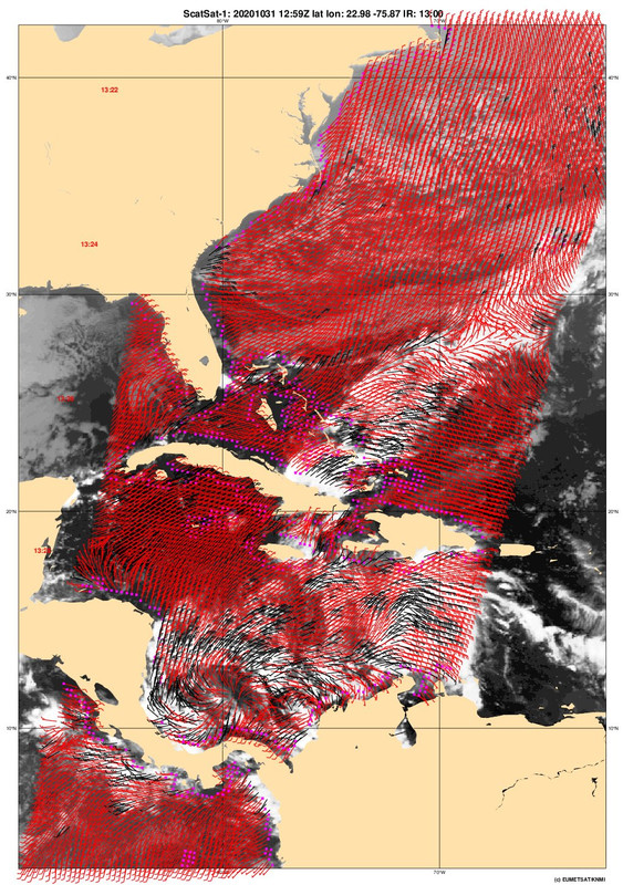
There is a LLC with a possible eye feature/dry slot.
0 likes   
Bill 2015 & Beta 2020

Winter 2020-2021 :cold:

All observations are in Tecumseh, OK unless otherwise noted.

Winter posts are focused mainly for Oklahoma & Texas.

Take any of my forecasts with a grain of salt, refer to the NWS, SPC, and NHC for official information

Never say Never with weather! Because ANYTHING is possible!

Aric Dunn
Category 5
Category 5
Posts: 21238
Age: 42
Joined: Sun Sep 19, 2004 9:58 pm
Location: Ready for the Chase.
Contact:

Re: ATL: INVEST 96L - Discussion

#282 Postby Aric Dunn » Sat Oct 31, 2020 11:08 am

Looks like we are going to get some RI out of this over the next 36 hours...
3 likes   
Note: If I make a post that is brief. Please refer back to previous posts for the analysis or reasoning. I do not re-write/qoute what my initial post said each time.
If there is nothing before... then just ask :)

Space & Atmospheric Physicist, Embry-Riddle Aeronautical University,
I believe the sky is falling...

User avatar
Kazmit
Category 5
Category 5
Posts: 2124
Age: 22
Joined: Mon Jul 25, 2016 8:49 am
Location: Williamsburg, VA / Bermuda

Re: ATL: INVEST 96L - Discussion

#283 Postby Kazmit » Sat Oct 31, 2020 11:13 am

NDG wrote:
Weather Dude wrote:

That's a dry slot... Not an eye


I agree, is just a dry slot within the strong mid level circulation.
If it has a closed LLC is is still west of it.

https://i.imgur.com/h7UAkOn.jpg

It looks like a mid-range TS with that banding...
0 likes   
Igor 2010, Sandy 2012, Fay 2014, Gonzalo 2014, Joaquin 2015, Nicole 2016, Humberto 2019

I am only a tropical weather enthusiast. My predictions are not official and may or may not be backed by sound meteorological data. For official information, please refer to the NHC and NWS products.

Aric Dunn
Category 5
Category 5
Posts: 21238
Age: 42
Joined: Sun Sep 19, 2004 9:58 pm
Location: Ready for the Chase.
Contact:

Re: ATL: INVEST 96L - Discussion

#284 Postby Aric Dunn » Sat Oct 31, 2020 11:16 am

Kazmit wrote:
NDG wrote:
Weather Dude wrote:That's a dry slot... Not an eye


I agree, is just a dry slot within the strong mid level circulation.
If it has a closed LLC is is still west of it.

https://i.imgur.com/h7UAkOn.jpg

It looks like a mid-range TS with that banding...


This is almost certainly Eta.
3 likes   
Note: If I make a post that is brief. Please refer back to previous posts for the analysis or reasoning. I do not re-write/qoute what my initial post said each time.
If there is nothing before... then just ask :)

Space & Atmospheric Physicist, Embry-Riddle Aeronautical University,
I believe the sky is falling...

User avatar
ElectricStorm
Category 5
Category 5
Posts: 5044
Age: 24
Joined: Tue Aug 13, 2019 11:23 pm
Location: Skiatook, OK / Norman, OK

Re: ATL: INVEST 96L - Discussion

#285 Postby ElectricStorm » Sat Oct 31, 2020 11:18 am

Aric Dunn wrote:
Kazmit wrote:
NDG wrote:
I agree, is just a dry slot within the strong mid level circulation.
If it has a closed LLC is is still west of it.

https://i.imgur.com/h7UAkOn.jpg

It looks like a mid-range TS with that banding...


This is almost certainly Eta.

Yeah I'm kinda surprised they didn't upgrade
0 likes   
B.S Meteorology, University of Oklahoma '25

Please refer to the NHC, NWS, or SPC for official information.

User avatar
NDG
S2K Supporter
S2K Supporter
Posts: 15446
Joined: Sun Jul 09, 2006 10:14 pm
Location: Orlando, FL

Re: ATL: INVEST 96L - Discussion

#286 Postby NDG » Sat Oct 31, 2020 11:20 am

I do however think it has a well defined closed circulation, just to the west of the MLC.
The NHC must have taken a well deserved morning off to not upgrade it at 11 AM :wink:

Image
6 likes   

User avatar
aspen
Category 5
Category 5
Posts: 8818
Joined: Sat Oct 12, 2019 7:10 pm
Location: Connecticut, USA

Re: ATL: INVEST 96L - Discussion

#287 Postby aspen » Sat Oct 31, 2020 11:21 am

At this rate, recon is gonna find a 55-60 kt TS when it arrives tomorrow.
2 likes   
Irene '11 Sandy '12 Hermine '16 5/15/2018 Derecho Fay '20 Isaias '20 Elsa '21 Henri '21 Ida '21

I am only a meteorology enthusiast who knows a decent amount about tropical cyclones. Look to the professional mets, the NHC, or your local weather office for the best information.

User avatar
SouthDadeFish
Professional-Met
Professional-Met
Posts: 2835
Joined: Thu Sep 23, 2010 2:54 pm
Location: Miami, FL
Contact:

Re: ATL: INVEST 96L - Discussion

#288 Postby SouthDadeFish » Sat Oct 31, 2020 11:21 am

I can see pretty clear low-level inflow out of the SW and a curved band forming on the south side of the system. Looks like a TC to me...
10 likes   

User avatar
cycloneye
Admin
Admin
Posts: 145293
Age: 68
Joined: Thu Oct 10, 2002 10:54 am
Location: San Juan, Puerto Rico

Re: ATL: INVEST 96L - Discussion

#289 Postby cycloneye » Sat Oct 31, 2020 11:26 am

For the members who are asking when recon will go, I just posted the TCPOD for Sunday and Monday. See the details at the 96L Recon thread
2 likes   
Visit the Caribbean-Central America Weather Thread where you can find at first post web cams,radars
and observations from Caribbean basin members Click Here

Aric Dunn
Category 5
Category 5
Posts: 21238
Age: 42
Joined: Sun Sep 19, 2004 9:58 pm
Location: Ready for the Chase.
Contact:

Re: ATL: INVEST 96L - Discussion

#290 Postby Aric Dunn » Sat Oct 31, 2020 11:28 am

So no recon Until tonorrow.. interesting.

going to have a hurricane by then with an eye and ASCAT showing its not closed lol
11 likes   
Note: If I make a post that is brief. Please refer back to previous posts for the analysis or reasoning. I do not re-write/qoute what my initial post said each time.
If there is nothing before... then just ask :)

Space & Atmospheric Physicist, Embry-Riddle Aeronautical University,
I believe the sky is falling...

Shell Mound
Category 5
Category 5
Posts: 2434
Age: 32
Joined: Thu Sep 07, 2017 3:39 pm
Location: St. Petersburg, FL → Scandinavia

Re: ATL: INVEST 96L - Discussion

#291 Postby Shell Mound » Sat Oct 31, 2020 11:30 am

wxman57 wrote:The requirements for a PTC advisory are that there is a high chance of development (check) AND that the potential storm is within 48 hrs of impacting a coastal region that the NHC warns for (nope). Looks like it will reach the coast of Nicaragua Tuesday evening. Therefore, about the earliest we could expect a PTC advisory would be tomorrow late afternoon. However, if you're curious what the NHC track would look like, it would look just like the consensus model (TVCN):

http://wxman57.com/images/TVCN.JPG

Note that the TVCN indicates a significant slowdown just before landfall. 96L may well loop along the coast of Central America and not move far inland at all.

The current rate of intensification means that 96L (Eta) is less likely to move well inland before stalling, looping offshore, and eventually heading northward.

I’m already thinking this could well become a high-end Cat-4 or even low-end Cat-5 before hitting Cabo Gracias a Dios, stalling, and then entering the GoH.*

*Gulf of Honduras

(At any rate, this won’t weaken much, if at all, due to the brevity of its landfall on the relatively flat, marshy Miskito Coast, near the Nicaragua–Honduras line.)

Don’t be shocked if both Central America and Cuba/Florida face the possibility of multiple Cat-4+ landfalls in association with 96L (future Eta).
3 likes   
CVW / MiamiensisWx / Shell Mound
The posts in this forum are NOT official forecasts and should not be used as such. They are just the opinion of the poster and may or may not be backed by sound meteorological data. They are NOT endorsed by any professional institution or STORM2K. For official information, please refer to products from the NHC and NWS.

User avatar
SFLcane
S2K Supporter
S2K Supporter
Posts: 10163
Age: 47
Joined: Sat Jun 05, 2010 1:44 pm
Location: Lake Worth Florida

Re: ATL: INVEST 96L - Discussion

#292 Postby SFLcane » Sat Oct 31, 2020 11:38 am

Shell Mound wrote:
wxman57 wrote:The requirements for a PTC advisory are that there is a high chance of development (check) AND that the potential storm is within 48 hrs of impacting a coastal region that the NHC warns for (nope). Looks like it will reach the coast of Nicaragua Tuesday evening. Therefore, about the earliest we could expect a PTC advisory would be tomorrow late afternoon. However, if you're curious what the NHC track would look like, it would look just like the consensus model (TVCN):

http://wxman57.com/images/TVCN.JPG

Note that the TVCN indicates a significant slowdown just before landfall. 96L may well loop along the coast of Central America and not move far inland at all.

The current rate of intensification means that 96L (Eta) is less likely to move well inland before stalling, looping offshore, and eventually heading northward.

I’m already thinking this could well become a high-end Cat-4 or even low-end Cat-5 before hitting Cabo Gracias a Dios, stalling, and then entering the GoH.*

*Gulf of Honduras

(At any rate, this won’t weaken much, if at all, due to the brevity of its landfall on the relatively flat, marshy Miskito Coast, near the Nicaragua–Honduras line.)

Don’t be shocked if both Central America and Cuba/Florida face the possibility of multiple Cat-4+ landfalls in association with 96L (future Eta).


You might just be right.
2 likes   

User avatar
SFLcane
S2K Supporter
S2K Supporter
Posts: 10163
Age: 47
Joined: Sat Jun 05, 2010 1:44 pm
Location: Lake Worth Florida

Re: ATL: INVEST 96L - Discussion

#293 Postby SFLcane » Sat Oct 31, 2020 11:47 am

Just a wave axis for now.

Image
0 likes   

Aric Dunn
Category 5
Category 5
Posts: 21238
Age: 42
Joined: Sun Sep 19, 2004 9:58 pm
Location: Ready for the Chase.
Contact:

Re: ATL: INVEST 96L - Discussion

#294 Postby Aric Dunn » Sat Oct 31, 2020 11:49 am

1 likes   
Note: If I make a post that is brief. Please refer back to previous posts for the analysis or reasoning. I do not re-write/qoute what my initial post said each time.
If there is nothing before... then just ask :)

Space & Atmospheric Physicist, Embry-Riddle Aeronautical University,
I believe the sky is falling...

Shell Mound
Category 5
Category 5
Posts: 2434
Age: 32
Joined: Thu Sep 07, 2017 3:39 pm
Location: St. Petersburg, FL → Scandinavia

Re: ATL: INVEST 96L - Discussion

#295 Postby Shell Mound » Sat Oct 31, 2020 11:50 am

Aric Dunn wrote:


Unlikely.

Yes, the circulation is small and is likely being resolved improperly by certain grids. A closed low-level centre may well exist or is about to form shortly.
2 likes   
CVW / MiamiensisWx / Shell Mound
The posts in this forum are NOT official forecasts and should not be used as such. They are just the opinion of the poster and may or may not be backed by sound meteorological data. They are NOT endorsed by any professional institution or STORM2K. For official information, please refer to products from the NHC and NWS.

Aric Dunn
Category 5
Category 5
Posts: 21238
Age: 42
Joined: Sun Sep 19, 2004 9:58 pm
Location: Ready for the Chase.
Contact:

Re: ATL: INVEST 96L - Discussion

#296 Postby Aric Dunn » Sat Oct 31, 2020 12:07 pm

Should be upgraded to Eta. at the very least TD.

Clear as day.

Image

Image
6 likes   
Note: If I make a post that is brief. Please refer back to previous posts for the analysis or reasoning. I do not re-write/qoute what my initial post said each time.
If there is nothing before... then just ask :)

Space & Atmospheric Physicist, Embry-Riddle Aeronautical University,
I believe the sky is falling...

User avatar
NDG
S2K Supporter
S2K Supporter
Posts: 15446
Joined: Sun Jul 09, 2006 10:14 pm
Location: Orlando, FL

Re: ATL: INVEST 96L - Discussion

#297 Postby NDG » Sat Oct 31, 2020 12:26 pm

Aric Dunn wrote:Should be upgraded to Eta. at the very least TD.

Clear as day.

https://i.ibb.co/ZL6zZcC/LABELS-19700101-000000-53.gif

https://i.ibb.co/59xwJsk/Capture.png


I was about to post the same satellite loop, very clearly an LLC, the SW inflow is also seen.
4 likes   

User avatar
wxman57
Moderator-Pro Met
Moderator-Pro Met
Posts: 22978
Age: 67
Joined: Sat Jun 21, 2003 8:06 pm
Location: Houston, TX (southwest)

Re: ATL: INVEST 96L - Discussion

#298 Postby wxman57 » Sat Oct 31, 2020 12:41 pm

Shell Mound wrote:
wxman57 wrote:The requirements for a PTC advisory are that there is a high chance of development (check) AND that the potential storm is within 48 hrs of impacting a coastal region that the NHC warns for (nope). Looks like it will reach the coast of Nicaragua Tuesday evening. Therefore, about the earliest we could expect a PTC advisory would be tomorrow late afternoon. However, if you're curious what the NHC track would look like, it would look just like the consensus model (TVCN):

http://wxman57.com/images/TVCN.JPG

Note that the TVCN indicates a significant slowdown just before landfall. 96L may well loop along the coast of Central America and not move far inland at all.

The current rate of intensification means that 96L (Eta) is less likely to move well inland before stalling, looping offshore, and eventually heading northward.

I’m already thinking this could well become a high-end Cat-4 or even low-end Cat-5 before hitting Cabo Gracias a Dios, stalling, and then entering the GoH.*

*Gulf of Honduras

(At any rate, this won’t weaken much, if at all, due to the brevity of its landfall on the relatively flat, marshy Miskito Coast, near the Nicaragua–Honduras line.)

Don’t be shocked if both Central America and Cuba/Florida face the possibility of multiple Cat-4+ landfalls in association with 96L (future Eta).


Yes, I can plot the TVCN hour-by-hour, as indicated below. I think we (forecasters) all want it to just MOVE INLAND AND DIE! (sorry for shouting) We're all ready for a break. Haven't been able to take any vacation days this summer. Myself, I accrued nearly 40 comp DAYS this summer plus I have 20 vacation days left. We are not allowed to carry either over to 2021. So, die, Eta, die! ;-)

Image
3 likes   

User avatar
cycloneye
Admin
Admin
Posts: 145293
Age: 68
Joined: Thu Oct 10, 2002 10:54 am
Location: San Juan, Puerto Rico

Re: ATL: INVEST 96L - Discussion

#299 Postby cycloneye » Sat Oct 31, 2020 12:49 pm

100%/100%

Tropical Weather Outlook
NWS National Hurricane Center Miami FL
200 PM EDT Sat Oct 31 2020

For the North Atlantic...Caribbean Sea and the Gulf of Mexico:

A vigorous tropical wave located over the central Caribbean Sea
continues to produce organized cloudiness and thunderstorms, and a
tropical depression appears to be forming. If this recent
development trend continues, then advisories will likely be
initiated on this disturbance this afternoon or evening while the
system moves generally westward at about 15 mph toward the western
Caribbean Sea. Interests in Jamaica, Honduras, and Nicaragua should
monitor the progress of this system. Regardless of development,
this disturbance is expected to produce heavy rainfall across
portions of Jamaica and southern Hispaniola through the weekend.
* Formation chance through 48 hours...high...near 100 percent.
* Formation chance through 5 days...high...near 100 percent.

$$
Forecaster Stewart/Berg
4 likes   
Visit the Caribbean-Central America Weather Thread where you can find at first post web cams,radars
and observations from Caribbean basin members Click Here

Wampadawg
Tropical Storm
Tropical Storm
Posts: 238
Joined: Wed Oct 14, 2020 10:28 am
Location: South Texas

Re: ATL: INVEST 96L - Discussion: 2 PM TWO=100%

#300 Postby Wampadawg » Sat Oct 31, 2020 12:56 pm

Has it slowed down?
0 likes   
Harvey,Hanna,Beta,Texas Winter storm2021,Nicholas,Beryl


Return to “2020”

Who is online

Users browsing this forum: No registered users and 6 guests