
ATL: ETA - Models
Moderator: S2k Moderators
Re: ATL: INVEST 96L - Models
0 likes
-
Spacecoast

- Category 2

- Posts: 773
- Joined: Thu Aug 31, 2017 2:03 pm

-
Shell Mound
- Category 5

- Posts: 2432
- Age: 33
- Joined: Thu Sep 07, 2017 3:39 pm
- Location: St. Petersburg, FL → Scandinavia
Re: ATL: INVEST 96L - Models
TheStormExpert wrote:Shell Mound wrote:I don’t think I’ve ever seen such sustained run-to-run consistency by the operational GFS in terms of track and intensity over five cycles. This isn’t a fluke...
Pre-Zeta going NE through Cuba and The Bahamas?
I meant that the GFS has been remarkably consistent over the past four runs and has done so against the ECMWF, the latter of which is failing badly intensity-wise.
0 likes
CVW / MiamiensisWx / Shell Mound
The posts in this forum are NOT official forecasts and should not be used as such. They are just the opinion of the poster and may or may not be backed by sound meteorological data. They are NOT endorsed by any professional institution or STORM2K. For official information, please refer to products from the NHC and NWS.
-
northjaxpro

- S2K Supporter

- Posts: 8900
- Joined: Mon Sep 27, 2010 11:21 am
- Location: Jacksonville, FL
Re: ATL: INVEST 96L - Models
Shell Mound wrote:I don’t think I’ve ever seen such sustained run-to-run consistency by the operational GFS in terms of track and intensity over five cycles. This isn’t a fluke...
100% agree. The GFS has definitely latched onto a solution in that if it materizes, will have HUGE implications
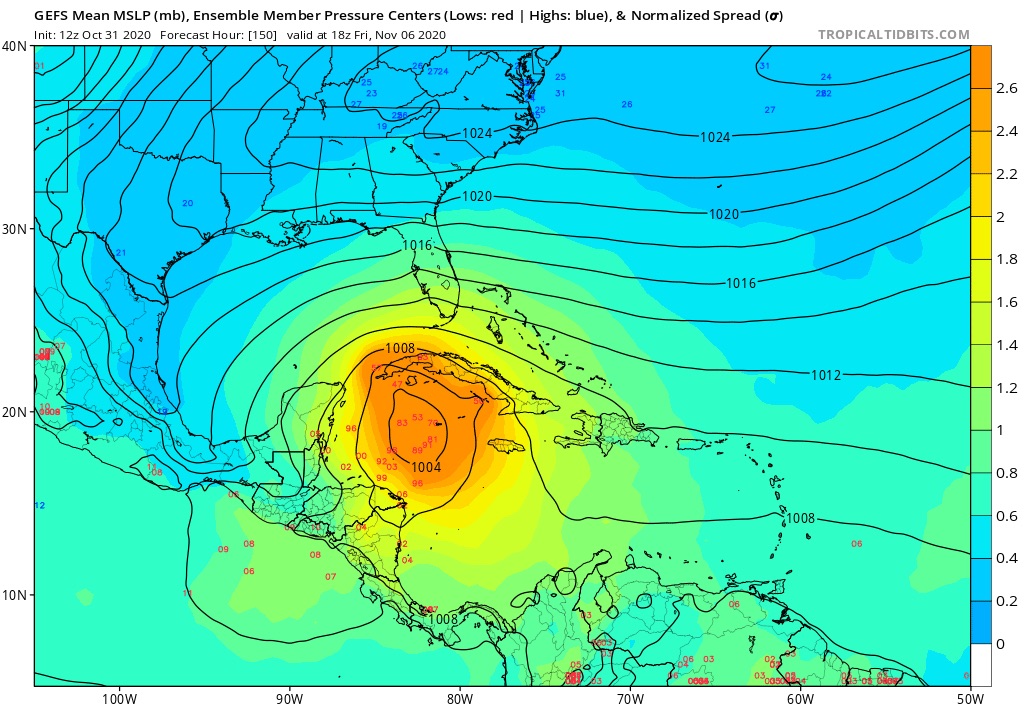
12ZGFS run has Eta making landfall as a major across Apalachee Bay near Steinhatchee in 252 hours.
Last edited by northjaxpro on Sat Oct 31, 2020 11:44 am, edited 2 times in total.
2 likes
NEVER, EVER SAY NEVER in the tropics and weather in general, and most importantly, with life itself!!
________________________________________________________________________________________
Fay 2008 Beryl 2012 Debby 2012 Colin 2016 Hermine 2016 Julia 2016 Matthew 2016 Irma 2017 Dorian 2019
________________________________________________________________________________________
Fay 2008 Beryl 2012 Debby 2012 Colin 2016 Hermine 2016 Julia 2016 Matthew 2016 Irma 2017 Dorian 2019
-
Weatherboy1

- Category 5
- Posts: 1190
- Age: 50
- Joined: Mon Jul 05, 2004 1:50 pm
- Location: Jupiter/Sarasota, FL
Re: ATL: INVEST 96L - Models
The persistence of 4 GFS runs now is interesting... but now we have the Canadian joining the “party” too. That is actually more interesting to me because it signals that the GFS isn’t all alone on an island by itself. Now to see if Euro shifts ...
2 likes
Re: ATL: INVEST 96L - Models
12Z UK moves WSW in N Nic almost all the way into the E PAC before dissipating: so, what 12Z GFS, ICON, UK, and CMC all have in common regardless of what does or doesn’t happen to FL later is that a good portion of Hond, Nic, and possibly Guat/Belize is facing an increasing threat of extreme flooding: any readers there in flood prone areas or in mudslide threatened areas need to be VERY vigilant!! I’m getting deeply concerned.
NEW TROPICAL CYCLONE FORECAST TO DEVELOP AFTER 60 HOURS
FORECAST POSITION AT T+ 60 : 13.8N 81.8W
LEAD CENTRAL MAXIMUM WIND
VERIFYING TIME TIME POSITION PRESSURE (MB) SPEED (KNOTS)
-------------- ---- -------- ------------- -------------
0000UTC 03.11.2020 60 13.8N 81.8W 1003 25
1200UTC 03.11.2020 72 14.2N 83.2W 1002 28
0000UTC 04.11.2020 84 13.8N 84.4W 1001 28
1200UTC 04.11.2020 96 13.2N 87.5W 1005 33
0000UTC 05.11.2020 108 CEASED TRACKING
Last edited by LarryWx on Sat Oct 31, 2020 11:50 am, edited 2 times in total.
3 likes
Personal Forecast Disclaimer:
The posts in this forum are NOT official forecasts and should not be used as such. They are just the opinion of the poster and may or may not be backed by sound meteorological data. They are NOT endorsed by any professional institution or storm2k.org. For official information, please refer to the NHC and NWS products.
The posts in this forum are NOT official forecasts and should not be used as such. They are just the opinion of the poster and may or may not be backed by sound meteorological data. They are NOT endorsed by any professional institution or storm2k.org. For official information, please refer to the NHC and NWS products.
-
Dean4Storms
- S2K Supporter
- Posts: 6358
- Age: 63
- Joined: Sun Aug 31, 2003 1:01 pm
- Location: Miramar Bch. FL
Re: ATL: INVEST 96L - Models
Yea, wouldn't ignore these GFS runs bringing this eventually Northward. It has done reasonably well in eventual western Carib. storm tracks this year where others buried them or even failed to develop them.
3 likes
Re: ATL: INVEST 96L - Models
12z GFS goes all-out regarding US impact. Landfalls in Florida, then goes through the entire east coast: Florida, Georgia, South Carolina, North Carolina, Virginia and now Maryland & Delaware at 270 hours. And might I add that Zeta is still 970 mbar at 270 hours, a full day after landfall.
4 likes
-
Shell Mound
- Category 5
- Posts: 2432
- Age: 33
- Joined: Thu Sep 07, 2017 3:39 pm
- Location: St. Petersburg, FL → Scandinavia
Re: ATL: INVEST 96L - Models
Weatherboy1 wrote:The persistence of 4 GFS runs now is interesting... but now we have the Canadian joining the “party” too. That is actually more interesting to me because it signals that the GFS isn’t all alone on an island by itself. Now to see if Euro shifts ...
Technically, the CMC does take 96L/Eta well inland over the mountainous interior, but does so extremely slowly. At the time of landfall 96L/Eta is barely moving at all.
It wouldn’t take much at all for future runs to show 96L/Eta stalling over the Miskito Coast and moving back offshore instead of heading west toward the mountains.
2 likes
CVW / MiamiensisWx / Shell Mound
The posts in this forum are NOT official forecasts and should not be used as such. They are just the opinion of the poster and may or may not be backed by sound meteorological data. They are NOT endorsed by any professional institution or STORM2K. For official information, please refer to products from the NHC and NWS.

-
cp79
Re: ATL: INVEST 96L - Models
kevin wrote:12z GFS goes all-out regarding US impact. Landfalls in Florida, then goes through the entire east coast: Florida, Georgia, South Carolina, North Carolina, Virginia and now Maryland & Delaware at 270 hours. And might I add that Zeta is still 970 mbar at 270 hours, a full day after landfall.
I just don’t know if the steering is there for a Fla landfall to happen. I’m not saying it can’t happen, but if it were to get picked up, I would think it would move more NE, not N. Or WNw and then NW if HP got a hold of it. But maybe they see something I don’t so we’ll see. Like I said, too early in the game to take any model seriously past 96 hrs. The Euro will be interesting in an hour.
All this said, there is a growing and concerning trend for it clipping CA and staying alive and drifting N. Getting closer to 50/50 of that happening.
0 likes
-
Blown Away

- S2K Supporter
- Posts: 10253
- Joined: Wed May 26, 2004 6:17 am
Re: ATL: INVEST 96L - Models
That’s medium range to boot, Euro and most ensembles as confident the other way into CA. Large disagreement between GFS/Euro kinda unusual even for medium range.
3 likes
Hurricane Eye Experience: David 79, Irene 99, Frances 04, Jeanne 04, Wilma 05… Hurricane Brush Experience: Andrew 92, Erin 95, Floyd 99, Matthew 16, Irma 17, Ian 22, Nicole 22…
-
jlauderdal
- S2K Supporter
- Posts: 7240
- Joined: Wed May 19, 2004 5:46 am
- Location: NE Fort Lauderdale
- Contact:
Re: RE: Re: ATL: INVEST 96L - Models
Sofla deflector shield is going, i will be back to fll tonightTheStormExpert wrote:The 12z GFS is west and slower on approach to Florida when compared to the 06z run. Must be correcting it’s right-bias. Folks anywhere from Texas, Louisiana to Florida better be watching this!
2 likes
-
DESTRUCTION5

- Category 5
- Posts: 4430
- Age: 44
- Joined: Wed Sep 03, 2003 11:25 am
- Location: Stuart, FL
Re: ATL: INVEST 96L - Models
12z Canadian comes north similar to GFS..
2 likes
GATOR NATION IS E V E R Y W H E R E !
Re: ATL: INVEST 96L - Models
Blown Away wrote:
That’s medium range to boot, Euro and most ensembles as confident the other way into CA. Large disagreement between GFS/Euro kinda unusual even for medium range.
Not only that, but even the 12Z GFS/GEFS imply a sig threat to parts of Honduras for extreme flooding and mudslides. It isn’t a black and white choice just between CA flooding and a FL hit. They may both occur and, if so, the FL threat could be from energy that is near the LAs now.
This is a very heavily FL concentrated BB. So, I realize and fully understand that many posts are going to be about FL and nowhere else. So, I (who am not in FL) am trying my best to make sure for the benefit of readers especially in Honduras and Nicaragua but also for those in Guatemala, Belize, and even SE MX that the potential flooding threat to them not be overlooked and instead be prepared for as best possible in case the 12Z consensus is right.
6 likes
Personal Forecast Disclaimer:
The posts in this forum are NOT official forecasts and should not be used as such. They are just the opinion of the poster and may or may not be backed by sound meteorological data. They are NOT endorsed by any professional institution or storm2k.org. For official information, please refer to the NHC and NWS products.
The posts in this forum are NOT official forecasts and should not be used as such. They are just the opinion of the poster and may or may not be backed by sound meteorological data. They are NOT endorsed by any professional institution or storm2k.org. For official information, please refer to the NHC and NWS products.
-
Shell Mound
- Category 5
- Posts: 2432
- Age: 33
- Joined: Thu Sep 07, 2017 3:39 pm
- Location: St. Petersburg, FL → Scandinavia
Re: ATL: INVEST 96L - Models
LarryWx wrote:Blown Away wrote:
That’s medium range to boot, Euro and most ensembles as confident the other way into CA. Large disagreement between GFS/Euro kinda unusual even for medium range.
Not only that, but even the 12Z GFS/GEFS imply a sig threat to parts of Honduras for extreme flooding and mudslides. It isn’t a black and white choice just between CA flooding and a FL hit. They may both occur and, if so, the FL threat could be from energy that is near the LAs now.
I don’t disagree with you at all, but I think the threat to Florida is high from this system alone, and that severe impacts to both CA and FL may occur from 96L.
3 likes
CVW / MiamiensisWx / Shell Mound
The posts in this forum are NOT official forecasts and should not be used as such. They are just the opinion of the poster and may or may not be backed by sound meteorological data. They are NOT endorsed by any professional institution or STORM2K. For official information, please refer to products from the NHC and NWS.
-
Blown Away
- S2K Supporter
- Posts: 10253
- Joined: Wed May 26, 2004 6:17 am
Re: ATL: INVEST 96L - Models
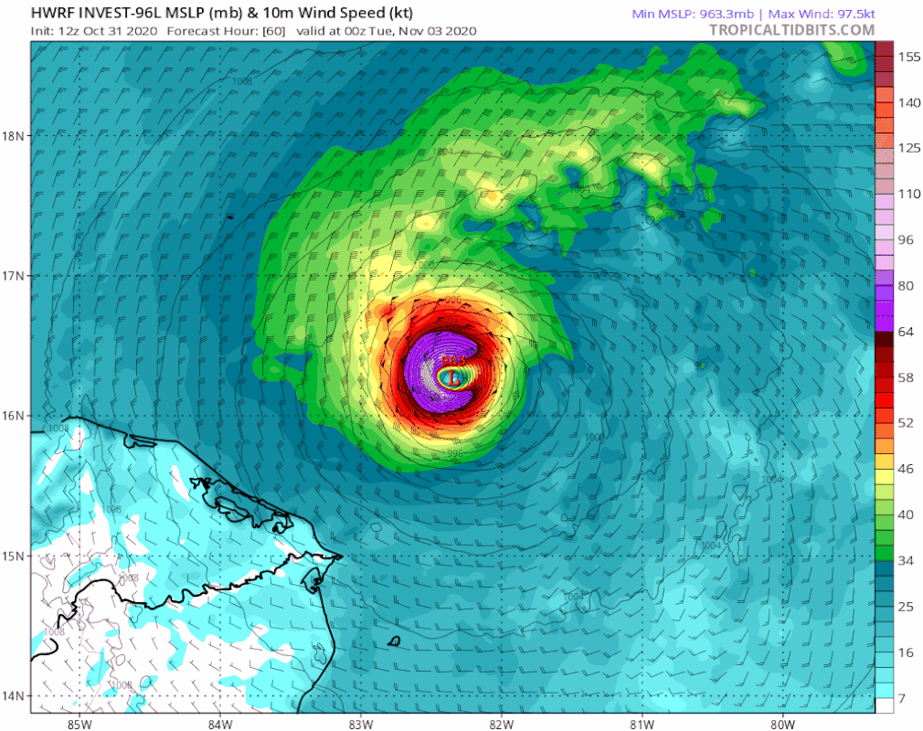
12z HWRF a full degree N shift at @84 hours and skimming Honduras N coast at that point.
0 likes
Hurricane Eye Experience: David 79, Irene 99, Frances 04, Jeanne 04, Wilma 05… Hurricane Brush Experience: Andrew 92, Erin 95, Floyd 99, Matthew 16, Irma 17, Ian 22, Nicole 22…
-
gatorcane

- S2K Supporter
- Posts: 23708
- Age: 48
- Joined: Sun Mar 13, 2005 3:54 pm
- Location: Boca Raton, FL
Re: ATL: INVEST 96L - Models
HWRF landfall in Nicaragua heading inland. I wouldn’t get too “excited“ about the GFS into Florida unless more good models show it. Inland into CA looks likely.
0 likes
-
Blown Away
- S2K Supporter
- Posts: 10253
- Joined: Wed May 26, 2004 6:17 am
Re: ATL: INVEST 96L - Models
gatorcane wrote:HWRF landfall in Nicaragua heading inland. I wouldn’t get too excited about the GFS into Florida unless more good models show it. Inland into CA looks likely.
https://i.postimg.cc/3JpBF8Y7/hwrf-mslp-wind-96-L-fh60-87.gif
Agree, but the 12z was a full degree N and model has trended N a bit the last few runs.
2 likes
Hurricane Eye Experience: David 79, Irene 99, Frances 04, Jeanne 04, Wilma 05… Hurricane Brush Experience: Andrew 92, Erin 95, Floyd 99, Matthew 16, Irma 17, Ian 22, Nicole 22…
-
gatorcane
- S2K Supporter
- Posts: 23708
- Age: 48
- Joined: Sun Mar 13, 2005 3:54 pm
- Location: Boca Raton, FL
Re: ATL: INVEST 96L - Models
Euro dives SW into Honduras/Nicaragua again. The model is very consistent with this.
Last edited by gatorcane on Sat Oct 31, 2020 1:08 pm, edited 1 time in total.
0 likes
Who is online
Users browsing this forum: No registered users and 62 guests