ATL: ETA - Models
Moderator: S2k Moderators
-
supercane4867
- Category 5

- Posts: 4966
- Joined: Wed Nov 14, 2012 10:43 am

Re: ATL: ETA - Models
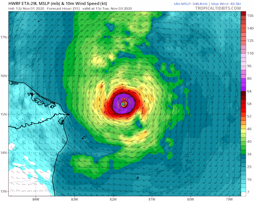
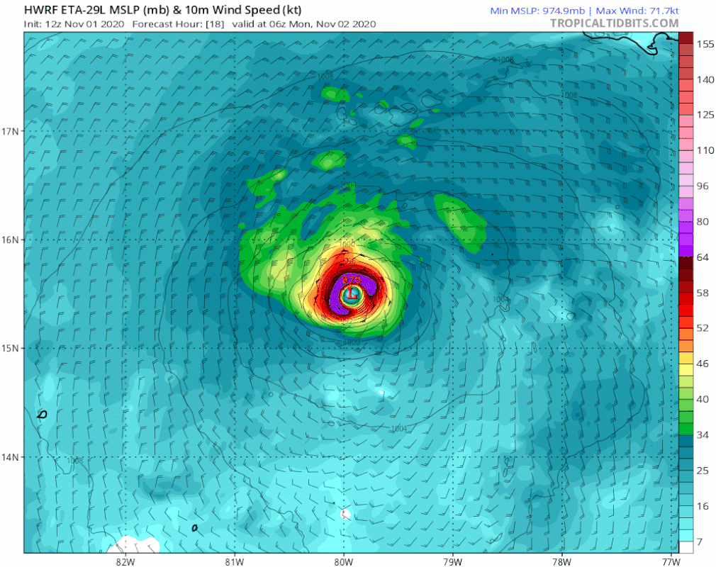
HWRF: 933 mbar NE of Honduras at 66 hours, EWRC beginning.
2 likes
Irene '11 Sandy '12 Hermine '16 5/15/2018 Derecho Fay '20 Isaias '20 Elsa '21 Henri '21 Ida '21
I am only a meteorology enthusiast who knows a decent amount about tropical cyclones. Look to the professional mets, the NHC, or your local weather office for the best information.
I am only a meteorology enthusiast who knows a decent amount about tropical cyclones. Look to the professional mets, the NHC, or your local weather office for the best information.

-
TallahasseeMan
- Tropical Storm

- Posts: 120
- Joined: Sat Aug 01, 2020 1:49 pm
Re: ATL: ETA - Models
At 78hrs this thing is just about to come ashore. Very different from 6z at about the same time.


Sent from my iPhone using Tapatalk
Sent from my iPhone using Tapatalk
2 likes
Direct hit: Francis '04, Jeanne '04, Wilma '05 Hermine '16 Michael '18
Outer bands: Katrina '05 Irma '17
Outer bands: Katrina '05 Irma '17
-
gatorcane

- S2K Supporter

- Posts: 23708
- Age: 48
- Joined: Sun Mar 13, 2005 3:54 pm
- Location: Boca Raton, FL
Re: ATL: ETA - Models
NDG wrote:gatorcane wrote:Shell Mound wrote:The run already is “going nuts” with Eta’s intensity so far. Also, take a look at this!

North turn starts over water by day two!
Looks like it does a full small loop and heading west again at 51 hours towards CA.
https://i.postimg.cc/zvxZcdzn/hwrf-mslp-wind-29-L-fh18-51.gif
You spoke too soon, general NW heading.
Still looks to move into Honduras, strong high over the Gulf to do this. The loop the HWRF does looks suspect.
Last edited by gatorcane on Sun Nov 01, 2020 1:01 pm, edited 4 times in total.
1 likes

Re: ATL: ETA - Models
12z HWRF still landfalls in CA, but way further north in Honduras and very strong due to the extra time it has over water.
0 likes


Re: ATL: ETA - Models
kevin wrote:12z HWRF still landfalls in CA, but way further north in Honduras and very strong due to the extra time it has over water.
Worst case scenario for Honduras as they not only get extremely heavy rain but also a 941 H skirting the N coast. Fortunately, it is a model that often has super wonky runs that are out in left field that often don’t come close to verifying. Let’s hope.
Last edited by LarryWx on Sun Nov 01, 2020 1:03 pm, edited 1 time in total.
0 likes
Personal Forecast Disclaimer:
The posts in this forum are NOT official forecasts and should not be used as such. They are just the opinion of the poster and may or may not be backed by sound meteorological data. They are NOT endorsed by any professional institution or storm2k.org. For official information, please refer to the NHC and NWS products.
The posts in this forum are NOT official forecasts and should not be used as such. They are just the opinion of the poster and may or may not be backed by sound meteorological data. They are NOT endorsed by any professional institution or storm2k.org. For official information, please refer to the NHC and NWS products.
Re: ATL: ETA - Models
aspen wrote:HWRF has a loop offshore of CA and a successful EWRC that leads to even more intensification as Eta heads north. Great news for CA (they don’t get Mitch 2.0), probably bad news for Cuba (might be a strong system at landfall).
I spoke too soon. HWRF track is very similar to Mitch.
0 likes
Irene '11 Sandy '12 Hermine '16 5/15/2018 Derecho Fay '20 Isaias '20 Elsa '21 Henri '21 Ida '21
I am only a meteorology enthusiast who knows a decent amount about tropical cyclones. Look to the professional mets, the NHC, or your local weather office for the best information.
I am only a meteorology enthusiast who knows a decent amount about tropical cyclones. Look to the professional mets, the NHC, or your local weather office for the best information.
-
SFLcane

- S2K Supporter
- Posts: 10281
- Age: 48
- Joined: Sat Jun 05, 2010 1:44 pm
- Location: Lake Worth Florida
Re: ATL: ETA - Models
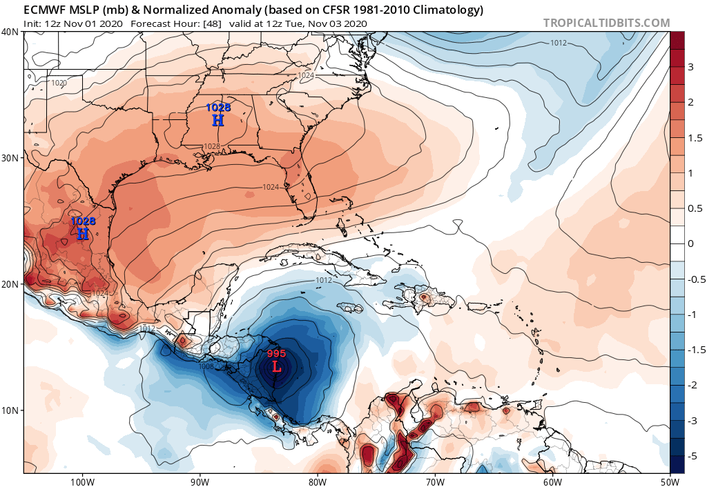
gatorcane wrote:Euro landfalls in Nicaragua in 48 hours at 995MB:
https://i.postimg.cc/3NkjpRc2/ecmwf-mslpa-Norm-watl-3.png
So did the 00z run.
0 likes
-
Shell Mound
- Category 5
- Posts: 2432
- Age: 33
- Joined: Thu Sep 07, 2017 3:39 pm
- Location: St. Petersburg, FL → Scandinavia
Re: ATL: ETA - Models
kevin wrote:12z HWRF still landfalls in CA, but way further north in Honduras and very strong due to the extra time it has over water.
Personally, I’d rely on a blend of the HWRF for short-term intensity and the EPS for synoptics. The projected mid- to upper-air pattern on the EPS in the same timeframe as the HWRF’s projected Honduran impact suggests a strong system would turn northward by that time. The TCVN also suggests that a strong system would begin making a slow but solid northward turn by then. So if Eta were in roughly the same position and featuring roughly the same intensity as on the HWRF, it would only briefly move inland over Honduras before lifting back northward over the Caribbean, or even fail to make landfall on the Central American isthmus at all, but instead impact the Bay Islands and/or the Swan Islands before recoiling from the mainland. In fact, the 12Z HWRF shows only a brief strike on Honduras before northward drift ensues by hour eighty-four.
Last edited by Shell Mound on Sun Nov 01, 2020 1:09 pm, edited 1 time in total.
2 likes
CVW / MiamiensisWx / Shell Mound
The posts in this forum are NOT official forecasts and should not be used as such. They are just the opinion of the poster and may or may not be backed by sound meteorological data. They are NOT endorsed by any professional institution or STORM2K. For official information, please refer to products from the NHC and NWS.
-
TallahasseeMan
- Tropical Storm
- Posts: 120
- Joined: Sat Aug 01, 2020 1:49 pm
Re: ATL: ETA - Models

Back offshore at 84hrs, what a split in the models we currently have.
Sent from my iPhone using Tapatalk
0 likes
Direct hit: Francis '04, Jeanne '04, Wilma '05 Hermine '16 Michael '18
Outer bands: Katrina '05 Irma '17
Outer bands: Katrina '05 Irma '17
-
gatorcane
- S2K Supporter
- Posts: 23708
- Age: 48
- Joined: Sun Mar 13, 2005 3:54 pm
- Location: Boca Raton, FL
Re: ATL: ETA - Models
12Z Euro track through day 5. Looks a lot like the official track and that is deep into CA.
2 likes
-
TheStormExpert
Re: ATL: ETA - Models
If Eta does redevelop in the Gulf of Honduras would it still be called Eta or Theta?
0 likes
-
TheStormExpert
Re: ATL: ETA - Models
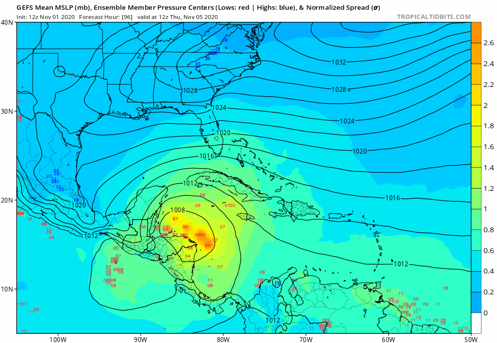
gatorcane wrote:GFS ensembles look weaker to me. Also that is quite a turn to the west near Cuba. The Euro showed it. Wonder if It never makes it out of the Caribbean or ends up well west of Florida?
https://i.postimg.cc/8PfwCYG0/gfs-ememb-lowlocs-watl-fh96-204.gif
I’ve been thinking the same thing all along. Either this never leaves the Caribbean or affects the northern Gulf Coast as a weak entity. Climatology is against us here in Florida.
0 likes
-
supercane4867
- Category 5
- Posts: 4966
- Joined: Wed Nov 14, 2012 10:43 am
Re: ATL: ETA - Models
12z HWRF is a flooding disaster of epic proportions for Central America.
2 likes

Who is online
Users browsing this forum: No registered users and 8 guests