ATL: ETA - Models

Moderator: S2k Moderators

Message
Author
User avatar
Nimbus
Category 5
Category 5
Posts: 5300
Joined: Mon Jul 19, 2004 10:54 am

Re: ATL: ETA - Models

#661 Postby Nimbus » Mon Nov 02, 2020 6:57 am

aspen wrote:930 mbar on the Euro for an Atlantic storm :double:

You really don’t see that a whole lot anymore...


Might make landfall in a relatively low population area but the flooding inland is always a disaster with these strong Central American storms. Maybe with a pinhole sized eye the size of the storm would stay smaller but the official forecast last night mentioned a large gyre over much of the area as this spreads out inland after landfall.
0 likes   

User avatar
SFLcane
S2K Supporter
S2K Supporter
Posts: 10163
Age: 47
Joined: Sat Jun 05, 2010 1:44 pm
Location: Lake Worth Florida

Re: ATL: ETA - Models

#662 Postby SFLcane » Mon Nov 02, 2020 7:05 am

I can see birds inside the eye. :ggreen: :eek:

Image
4 likes   

User avatar
SFLcane
S2K Supporter
S2K Supporter
Posts: 10163
Age: 47
Joined: Sat Jun 05, 2010 1:44 pm
Location: Lake Worth Florida

Re: ATL: ETA - Models

#663 Postby SFLcane » Mon Nov 02, 2020 7:13 am

Hwrf is stronger post CA @ 96hrs.
0 likes   

TheStormExpert

Re: ATL: ETA - Models

#664 Postby TheStormExpert » Mon Nov 02, 2020 7:16 am

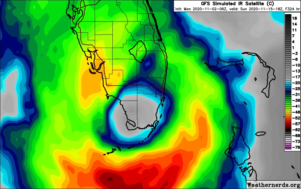
I guess it’s becoming more that there will be a hurricane in the NW Caribbean once Eta re-emerges in the Gulf of Honduras later this week. From there I could see this meandering around the NW Caribbean for a bit. The 06z GFS has a major hitting South Florida beyond 300hrs., been there too many times before to know better.
0 likes   

User avatar
SFLcane
S2K Supporter
S2K Supporter
Posts: 10163
Age: 47
Joined: Sat Jun 05, 2010 1:44 pm
Location: Lake Worth Florida

Re: ATL: ETA - Models

#665 Postby SFLcane » Mon Nov 02, 2020 7:20 am

TheStormExpert wrote:I guess it’s becoming more that there will be a hurricane in the NW Caribbean once Eta re-emerges in the Gulf of Honduras later this week. From there I could see this meandering around the NW Caribbean for a bit. The 06z GFS has a major hitting South Florida beyond 300hrs., been there too many times before to know better.


It’s not just op models there is ensemble support
from the EPS and GEFS.
0 likes   

User avatar
SFLcane
S2K Supporter
S2K Supporter
Posts: 10163
Age: 47
Joined: Sat Jun 05, 2010 1:44 pm
Location: Lake Worth Florida

Re: ATL: ETA - Models

#666 Postby SFLcane » Mon Nov 02, 2020 7:23 am

0 likes   

supercane4867
Category 5
Category 5
Posts: 4966
Joined: Wed Nov 14, 2012 10:43 am

Re: ATL: ETA - Models

#667 Postby supercane4867 » Mon Nov 02, 2020 7:23 am

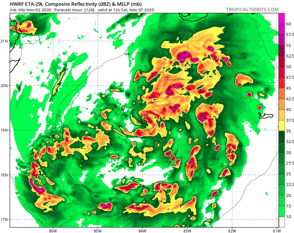
HWRF has an organized TS off the Honduras coast by 114hr. Looks like something that could strengthen very quickly over the deep warm waters of NW Caribbean

Image
0 likes   

User avatar
toad strangler
S2K Supporter
S2K Supporter
Posts: 4543
Joined: Sun Jul 28, 2013 3:09 pm
Location: Earth
Contact:

Re: ATL: ETA - Models

#668 Postby toad strangler » Mon Nov 02, 2020 7:25 am

SFLcane wrote:
TheStormExpert wrote:I guess it’s becoming more that there will be a hurricane in the NW Caribbean once Eta re-emerges in the Gulf of Honduras later this week. From there I could see this meandering around the NW Caribbean for a bit. The 06z GFS has a major hitting South Florida beyond 300hrs., been there too many times before to know better.


It’s not just op models there is ensemble support
from the EPS and GEFS.


A mid November strong 'cane into the FL peninsula. That would be one for the books. The ONLY one for the books.
0 likes   

SootyTern
S2K Supporter
S2K Supporter
Posts: 316
Age: 56
Joined: Sun Sep 05, 2004 5:09 pm
Location: NYC (formerly Homestead, FL)

Re: ATL: ETA - Models

#669 Postby SootyTern » Mon Nov 02, 2020 7:25 am

[quote="SFLcane"]I can see birds inside the eye. :ggreen: :eek:

that would bring Sooty terns over my house for sure
Last edited by SootyTern on Mon Nov 02, 2020 7:26 am, edited 1 time in total.
3 likes   
Disclaimer:
The posts in this forum are NOT official forecasts and should not be used as such. For official information, please refer to the NHC and NWS products.

Gulf Coast: Opal '95 Georges '98 / So Fla: Katrina '05 Wilma '05 Irma '17

TheStormExpert

Re: ATL: ETA - Models

#670 Postby TheStormExpert » Mon Nov 02, 2020 7:26 am

SFLcane wrote:
TheStormExpert wrote:I guess it’s becoming more that there will be a hurricane in the NW Caribbean once Eta re-emerges in the Gulf of Honduras later this week. From there I could see this meandering around the NW Caribbean for a bit. The 06z GFS has a major hitting South Florida beyond 300hrs., been there too many times before to know better.


It’s not just op models there is ensemble support
from the EPS and GEFS.

Still it’s long range and will likely change.
0 likes   

User avatar
SFLcane
S2K Supporter
S2K Supporter
Posts: 10163
Age: 47
Joined: Sat Jun 05, 2010 1:44 pm
Location: Lake Worth Florida

Re: ATL: ETA - Models

#671 Postby SFLcane » Mon Nov 02, 2020 7:27 am

toad strangler wrote:
SFLcane wrote:
TheStormExpert wrote:I guess it’s becoming more that there will be a hurricane in the NW Caribbean once Eta re-emerges in the Gulf of Honduras later this week. From there I could see this meandering around the NW Caribbean for a bit. The 06z GFS has a major hitting South Florida beyond 300hrs., been there too many times before to know better.


It’s not just op models there is ensemble support
from the EPS and GEFS.


A mid November strong 'cane into the FL peninsula. That would be one for the books. The ONLY one for the books.


Hey Toad!

Sure thing I get it but unfortunately the support is there.
0 likes   

User avatar
SFLcane
S2K Supporter
S2K Supporter
Posts: 10163
Age: 47
Joined: Sat Jun 05, 2010 1:44 pm
Location: Lake Worth Florida

Re: ATL: ETA - Models

#672 Postby SFLcane » Mon Nov 02, 2020 7:30 am

TheStormExpert wrote:
SFLcane wrote:
TheStormExpert wrote:I guess it’s becoming more that there will be a hurricane in the NW Caribbean once Eta re-emerges in the Gulf of Honduras later this week. From there I could see this meandering around the NW Caribbean for a bit. The 06z GFS has a major hitting South Florida beyond 300hrs., been there too many times before to know better.


It’s not just op models there is ensemble support
from the EPS and GEFS.

Still it’s long range and will likely change.


Yea let’s Just disregard the euro and gfs ensembles as outliers. :roll: This below is mounting evidence

Image
2 likes   

User avatar
SFLcane
S2K Supporter
S2K Supporter
Posts: 10163
Age: 47
Joined: Sat Jun 05, 2010 1:44 pm
Location: Lake Worth Florida

Re: ATL: ETA - Models

#673 Postby SFLcane » Mon Nov 02, 2020 7:32 am

Hwrf with a rapid deepening system post CA.

Image
0 likes   

User avatar
NDG
S2K Supporter
S2K Supporter
Posts: 15446
Joined: Sun Jul 09, 2006 10:14 pm
Location: Orlando, FL

Re: ATL: ETA - Models

#674 Postby NDG » Mon Nov 02, 2020 7:33 am

06z Euro has Eta slowing down and doing a couple of loop holes at landfall before eventually moving more Inland towards Honduras.

Image
0 likes   

User avatar
toad strangler
S2K Supporter
S2K Supporter
Posts: 4543
Joined: Sun Jul 28, 2013 3:09 pm
Location: Earth
Contact:

Re: ATL: ETA - Models

#675 Postby toad strangler » Mon Nov 02, 2020 7:36 am

SFLcane wrote:
toad strangler wrote:
SFLcane wrote:
It’s not just op models there is ensemble support
from the EPS and GEFS.


A mid November strong 'cane into the FL peninsula. That would be one for the books. The ONLY one for the books.


Hey Toad!

Sure thing I get it but unfortunately the support is there.


I was camping for 5 days and come back to this LOL
Seeing the ensemble support from bot the GEFS and the EPS is eye opening for sure. :eek:
So far out though and such a weird set-up. Will be interesting. Gun to head I'd still bet on a climo scoot out to the S & E fo FL in the end.
0 likes   

User avatar
NDG
S2K Supporter
S2K Supporter
Posts: 15446
Joined: Sun Jul 09, 2006 10:14 pm
Location: Orlando, FL

Re: ATL: ETA - Models

#676 Postby NDG » Mon Nov 02, 2020 7:36 am

Past 5 days is anybody's guess, nothing is written on stone past that range.
2 likes   

AutoPenalti
Category 5
Category 5
Posts: 4030
Age: 29
Joined: Mon Aug 17, 2015 4:16 pm
Location: Ft. Lauderdale, Florida

Re: ATL: ETA - Models

#677 Postby AutoPenalti » Mon Nov 02, 2020 7:48 am

If HWRF still has a core and intensifies this past CA, then I’ll be concerned.
0 likes   
The posts in this forum are NOT official forecasts and should not be used as such. They are just the opinion of the poster and may or may not be backed by sound meteorological data. They are NOT endorsed by any professional institution or STORM2K. For official information, please refer to products from the NHC and NWS.


Model Runs Cheat Sheet:
GFS (5:30 AM/PM, 11:30 AM/PM)
HWRF, GFDL, UKMET, NAVGEM (6:30-8:00 AM/PM, 12:30-2:00 AM/PM)
ECMWF (1:45 AM/PM)

TCVN
is a weighted averaged

User avatar
SFLcane
S2K Supporter
S2K Supporter
Posts: 10163
Age: 47
Joined: Sat Jun 05, 2010 1:44 pm
Location: Lake Worth Florida

Re: ATL: ETA - Models

#678 Postby SFLcane » Mon Nov 02, 2020 7:50 am

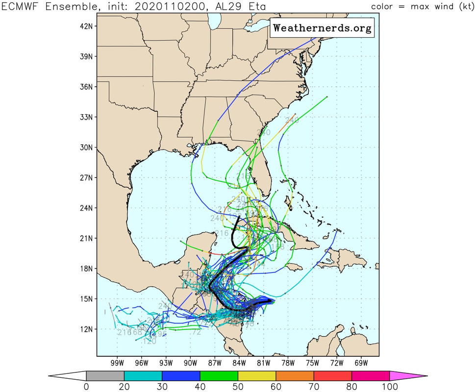
Remember when these ensembles were going to the epac just a few days ago?

Image
2 likes   

User avatar
SFLcane
S2K Supporter
S2K Supporter
Posts: 10163
Age: 47
Joined: Sat Jun 05, 2010 1:44 pm
Location: Lake Worth Florida

Re: ATL: ETA - Models

#679 Postby SFLcane » Mon Nov 02, 2020 8:08 am

Image
1 likes   

User avatar
SFLcane
S2K Supporter
S2K Supporter
Posts: 10163
Age: 47
Joined: Sat Jun 05, 2010 1:44 pm
Location: Lake Worth Florida

Re: ATL: ETA - Models

#680 Postby SFLcane » Mon Nov 02, 2020 8:14 am

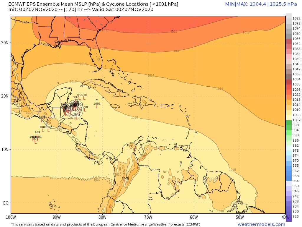
Here is the 06z euro ensembles. Concentration in NW Caribbean just about 100hrs out

Image
0 likes   


Return to “2020”

Who is online

Users browsing this forum: No registered users and 2 guests