ATL: ETA - Models
Moderator: S2k Moderators
-
SouthFLTropics

- Category 5

- Posts: 4258
- Age: 50
- Joined: Thu Aug 14, 2003 8:04 am
- Location: Port St. Lucie, Florida
Re: ATL: ETA - Models
Euro hits the tip of Florida. Euro much slower than the rest...Looks to allow the high to build in more. Probably will curve back into the GOM.
0 likes
Fourth Generation Florida Native
Personal Storm History: David 79, Andrew 92, Erin 95, Floyd 99, Irene 99, Frances 04, Jeanne 04, Wilma 05, Matthew 16, Irma 17, Ian 22, Nicole 22, Milton 24
Personal Storm History: David 79, Andrew 92, Erin 95, Floyd 99, Irene 99, Frances 04, Jeanne 04, Wilma 05, Matthew 16, Irma 17, Ian 22, Nicole 22, Milton 24
-
Hypercane_Kyle

- Category 5
- Posts: 3465
- Joined: Sat Mar 07, 2015 7:58 pm
- Location: Cape Canaveral, FL
Re: ATL: ETA - Models
SouthFLTropics wrote:Euro hits the tip of Florida. Euro much slower than the rest...Looks to allow the high to build in more. Probably will curve back into the GOM.
The Euro is actually the closest to the official track in terms of timing right now.
0 likes
My posts are my own personal opinion, defer to the National Hurricane Center (NHC) and other NOAA products for decision making during hurricane season.
-
Evil Jeremy

- S2K Supporter

- Posts: 5463
- Age: 32
- Joined: Mon Apr 10, 2006 2:10 pm
- Location: Los Angeles, CA
Re: ATL: ETA - Models
NHC might need to make big adjustments to the 4-5 day part of the forecast cone at 4pm based on the 12z models.
In 120 hours, CMC and ICON have this in the FL straits, Navy is almost in the Central Bahamas, GFS at Lake O, HWRF riding up the FL east coast, and the ECMWF on the South side of Cuba. ECMWF is the slow outlier right now.
NHC doesn't like making big shifts, but if the next model suite maintains the pattern from 12z, NHC will need to play catch up re; the forecast timing. All depends how much they weigh ECMWF vs the field... Even splitting the difference needs a chunky shift right now.
0 likes
Frances 04 / Jeanne 04 / Katrina 05 / Wilma 05 / Fay 08 / Debby 12 / Andrea 13 / Colin 16 / Hermine 16 / Matthew 16 / Irma 17

-
gatorcane

- S2K Supporter
- Posts: 23708
- Age: 48
- Joined: Sun Mar 13, 2005 3:54 pm
- Location: Boca Raton, FL
Re: ATL: ETA - Models
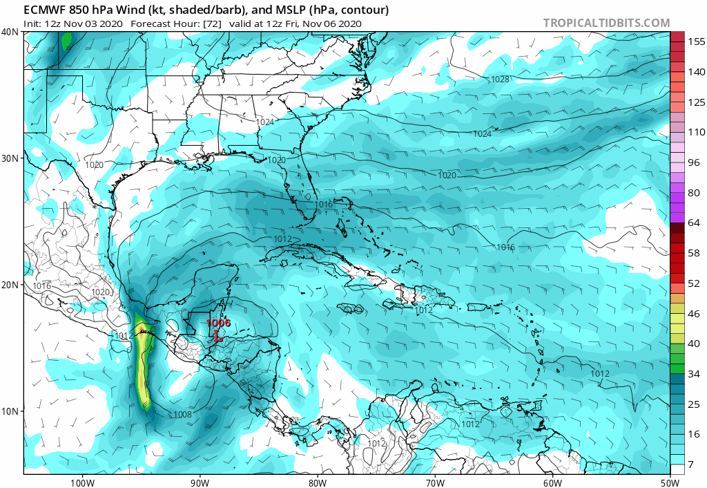
12Z Euro through 168 hours, looks like the Euro is also transitioning to subtropical and weakening as it turns west:
0 likes
-
SFLcane

- S2K Supporter
- Posts: 10281
- Age: 48
- Joined: Sat Jun 05, 2010 1:44 pm
- Location: Lake Worth Florida
Re: ATL: ETA - Models
Some consensus in the 12z guidance some impacts potentially are coming to SFL. Could it be stronger sure depends on what takes place with Eta in CA. The way things have gone this season I’d bet on something stronger but we will see
3 likes
-
Hypercane_Kyle
- Category 5
- Posts: 3465
- Joined: Sat Mar 07, 2015 7:58 pm
- Location: Cape Canaveral, FL
Re: ATL: ETA - Models
12z Euro lookin' pretty unimpressive as far as intensity goes.
0 likes
My posts are my own personal opinion, defer to the National Hurricane Center (NHC) and other NOAA products for decision making during hurricane season.


Re: ATL: ETA - Models
We won't know for sure until it emerges from CA, but the some of the models definitely show some very nasty possibilities for Cuba and the US. Tbh I wouldn't really look at intensity right now. Remember that many of the globals and even non-global models didn't forecast Eta to ever become a major hurricane up until the point that it actually became one. For now, the best we can read from the models is that depending on how Eta emerges from CA there is a risk of reorganization and thus a possible threat for Cuba and the US down the line.
4 likes
-
SFLcane
- S2K Supporter
- Posts: 10281
- Age: 48
- Joined: Sat Jun 05, 2010 1:44 pm
- Location: Lake Worth Florida
Re: ATL: ETA - Models
kevin wrote:We won't know for sure until it emerges from CA, but the some of the models definitely show some very nasty possibilities for Cuba and the US. Tbh I wouldn't really look at intensity right now. Remember that many of the globals and even non-global models didn't forecast Eta to ever become a major hurricane up until the point that it actually became one. For now, the best we can read from the models is that depending on how Eta emerges from CA there is a risk of reorganization and thus a possible threat for Cuba and the US down the line.
Exactly my point missed completely by the euro and gfs. Especially the euro model
3 likes
Re: ATL: ETA - Models
12Z Euro: Eta coming NE into NW FL fairly similarly to Kate of 1985, the only post mid October storm on record to do so I think.
Last edited by LarryWx on Tue Nov 03, 2020 2:01 pm, edited 1 time in total.
0 likes
Personal Forecast Disclaimer:
The posts in this forum are NOT official forecasts and should not be used as such. They are just the opinion of the poster and may or may not be backed by sound meteorological data. They are NOT endorsed by any professional institution or storm2k.org. For official information, please refer to the NHC and NWS products.
The posts in this forum are NOT official forecasts and should not be used as such. They are just the opinion of the poster and may or may not be backed by sound meteorological data. They are NOT endorsed by any professional institution or storm2k.org. For official information, please refer to the NHC and NWS products.

-
p1nheadlarry

- Category 2

- Posts: 672
- Age: 34
- Joined: Wed Jan 29, 2014 2:42 pm
- Location: SR County FL
Re: ATL: ETA - Models
Evil Jeremy wrote:NHC might need to make big adjustments to the 4-5 day part of the forecast cone at 4pm based on the 12z models.
In 120 hours, CMC and ICON have this in the FL straits, Navy is almost in the Central Bahamas, GFS at Lake O, HWRF riding up the FL east coast, and the ECMWF on the South side of Cuba. ECMWF is the slow outlier right now.
NHC doesn't like making big shifts, but if the next model suite maintains the pattern from 12z, NHC will need to play catch up re; the forecast timing. All depends how much they weigh ECMWF vs the field... Even splitting the difference needs a chunky shift right now.
Analogs are not forecasts, but this was the same thing that happened during Joaquin in 2015. Euro was the slow, southward diving outlier, and it was right.
3 likes
--;->#GoNoles--;->.
-
DESTRUCTION5

- Category 5
- Posts: 4430
- Age: 44
- Joined: Wed Sep 03, 2003 11:25 am
- Location: Stuart, FL
Re: ATL: ETA - Models
12z HWRF rakes the whole east coast of FL
0 likes
GATOR NATION IS E V E R Y W H E R E !
-
SouthFLTropics
- Category 5
- Posts: 4258
- Age: 50
- Joined: Thu Aug 14, 2003 8:04 am
- Location: Port St. Lucie, Florida
Re: ATL: ETA - Models
p1nheadlarry wrote:Evil Jeremy wrote:NHC might need to make big adjustments to the 4-5 day part of the forecast cone at 4pm based on the 12z models.
In 120 hours, CMC and ICON have this in the FL straits, Navy is almost in the Central Bahamas, GFS at Lake O, HWRF riding up the FL east coast, and the ECMWF on the South side of Cuba. ECMWF is the slow outlier right now.
NHC doesn't like making big shifts, but if the next model suite maintains the pattern from 12z, NHC will need to play catch up re; the forecast timing. All depends how much they weigh ECMWF vs the field... Even splitting the difference needs a chunky shift right now.
Analogs are not forecasts, but this was the same thing that happened during Joaquin in 2015. Euro was the slow, southward diving outlier, and it was right.
The problem with this is that the Euro of 2020 is not the same Euro from 2015. The 2020 Euro has, for the most part, be atrocious this year. The general consensus from the majority of the models is that something will emerge in the Gulf of Honduras and head NE towards Cuba. What form or shape its in is to be determined. Also, how far Northeast does it go before being turned back West, assuming it does get turned back. It may instead keep going right out into the Atlantic. Too early right now to determine what position or strength that high will be.
2 likes
Fourth Generation Florida Native
Personal Storm History: David 79, Andrew 92, Erin 95, Floyd 99, Irene 99, Frances 04, Jeanne 04, Wilma 05, Matthew 16, Irma 17, Ian 22, Nicole 22, Milton 24
Personal Storm History: David 79, Andrew 92, Erin 95, Floyd 99, Irene 99, Frances 04, Jeanne 04, Wilma 05, Matthew 16, Irma 17, Ian 22, Nicole 22, Milton 24


Re: ATL: ETA - Models
12Z EPS says Kate #2 is a real possibility;

0 likes
Personal Forecast Disclaimer:
The posts in this forum are NOT official forecasts and should not be used as such. They are just the opinion of the poster and may or may not be backed by sound meteorological data. They are NOT endorsed by any professional institution or storm2k.org. For official information, please refer to the NHC and NWS products.
The posts in this forum are NOT official forecasts and should not be used as such. They are just the opinion of the poster and may or may not be backed by sound meteorological data. They are NOT endorsed by any professional institution or storm2k.org. For official information, please refer to the NHC and NWS products.
-
jlauderdal
- S2K Supporter
- Posts: 7240
- Joined: Wed May 19, 2004 5:46 am
- Location: NE Fort Lauderdale
- Contact:


Who is online
Users browsing this forum: No registered users and 10 guests