ATL: ETA - Models
Moderator: S2k Moderators
-
TheStormExpert
-
TheStormExpert
Re: ATL: ETA - Models
boca wrote:If the models are using Eta the circulation is almost in the Pacific so I saw this area WSW of Jamaica this morning look interesting. I wonder if the system that’s forecast to develop in the Gulf of Honduras is something else the models are picking up.
You’d think considering the old circulation is going into the East Pacific and the MLC is forecasted to degenerate into a remnant low today that it would be renamed Theta.
1 likes

Re: ATL: ETA - Models
SFLcane wrote:06z euro only runs to 90hrs..
https://i.postimg.cc/g2P7fTYr/BF8-F633-F-0-BC3-4-A17-A030-D5-B9-BC5-D5946.png
What general direction is it going at the end of the run? Had it begun its westward turn?
0 likes
Andrew (1992), Irene (1999), Frances (2004), Katrina (2005), Wilma (2005), Fay (2008), Irma (2017), Eta (2020), Ian (2022)
-
SFLcane

- S2K Supporter

- Posts: 10281
- Age: 48
- Joined: Sat Jun 05, 2010 1:44 pm
- Location: Lake Worth Florida
Re: ATL: ETA - Models
Nuno wrote:SFLcane wrote:06z euro only runs to 90hrs..
https://i.postimg.cc/g2P7fTYr/BF8-F633-F-0-BC3-4-A17-A030-D5-B9-BC5-D5946.png
What general direction is it going at the end of the run? Had it begun its westward turn?
Appears to be heading NW
0 likes

Re: ATL: ETA - Models
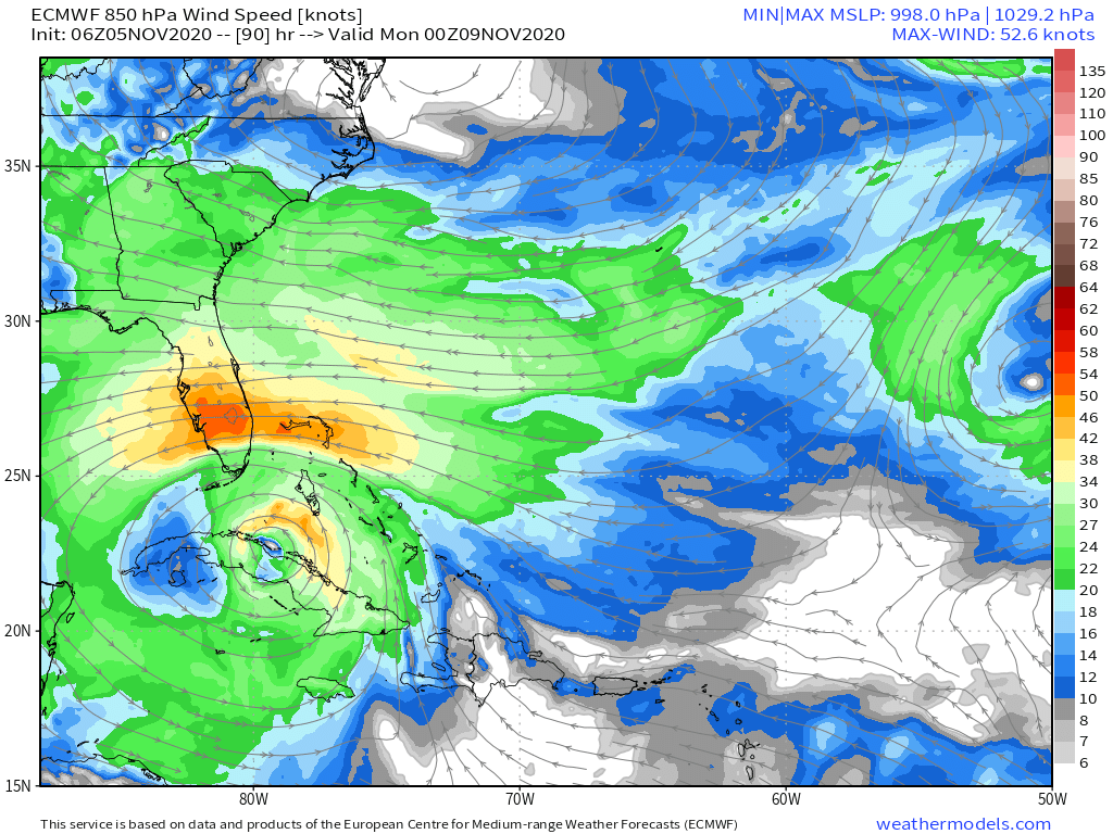
Both the 06z GFS and 00z Euro push Eta through the Florida Straits and have it get down to the Yucatán Channel again. It seems like there’s a continuing westward shift in the track. Maybe it’s possible that Eta spends a longer time in the Caribbean, or it eventually returns after a Cuba landfall.
0 likes
Irene '11 Sandy '12 Hermine '16 5/15/2018 Derecho Fay '20 Isaias '20 Elsa '21 Henri '21 Ida '21
I am only a meteorology enthusiast who knows a decent amount about tropical cyclones. Look to the professional mets, the NHC, or your local weather office for the best information.
I am only a meteorology enthusiast who knows a decent amount about tropical cyclones. Look to the professional mets, the NHC, or your local weather office for the best information.
-
TheStormExpert

-
SFLcane
- S2K Supporter
- Posts: 10281
- Age: 48
- Joined: Sat Jun 05, 2010 1:44 pm
- Location: Lake Worth Florida
Re: ATL: ETA - Models
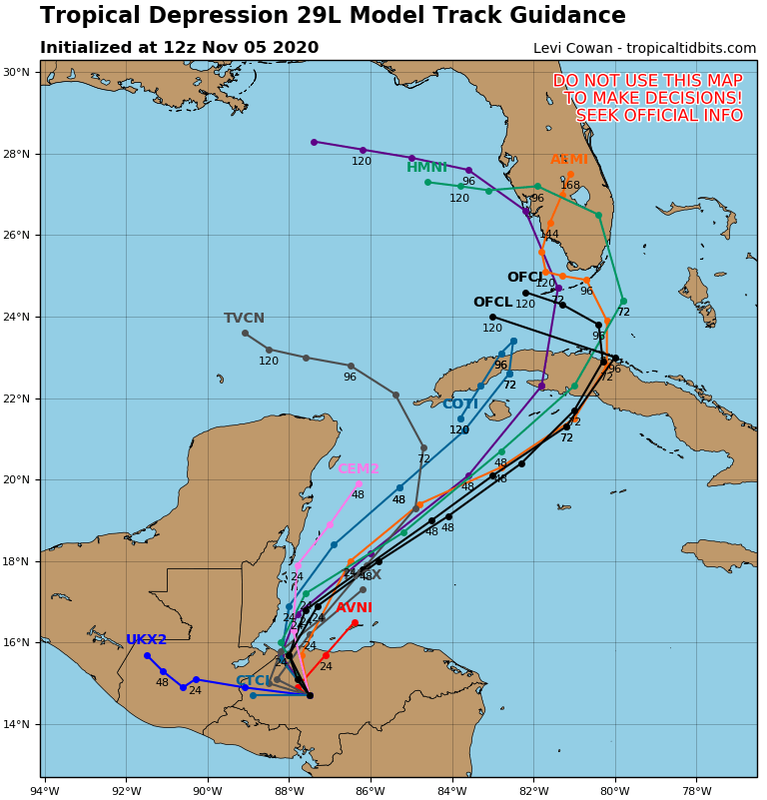
TheStormExpert wrote:12z Track Guidance. TVCN shoots it through the Yucatán Channel.
https://i.imgur.com/BtAwBcz.png
TCVN has been going through there since early 00z yesterday lol + no model shows this.
In a nutshell this morning, slower, and more west / south.
2 likes
-
AutoPenalti
- Category 5

- Posts: 4091
- Age: 29
- Joined: Mon Aug 17, 2015 4:16 pm
- Location: Ft. Lauderdale, Florida
Re: ATL: ETA - Models
TheStormExpert wrote:12z Track Guidance. TVCN shoots it through the Yucatán Channel.
https://i.imgur.com/BtAwBcz.png
That's a massive ridge developing if it does verify.
0 likes
The posts in this forum are NOT official forecasts and should not be used as such. They are just the opinion of the poster and may or may not be backed by sound meteorological data. They are NOT endorsed by any professional institution or STORM2K. For official information, please refer to products from the NHC and NWS.
Model Runs Cheat Sheet:
GFS (5:30 AM/PM, 11:30 AM/PM)
HWRF, GFDL, UKMET, NAVGEM (6:30-8:00 AM/PM, 12:30-2:00 AM/PM)
ECMWF (1:45 AM/PM)
TCVN is a weighted averaged
-
Emmett_Brown

- Category 5
- Posts: 1433
- Joined: Wed Aug 24, 2005 9:10 pm
- Location: Sarasota FL
Re: ATL: ETA - Models
6Z GFS is showing a more favorable upper level environment over the E GOM at about 120 hours. More upper level anticyclonic flow/less shear than previous runs. This matches well with the more active 6Z GEFS ensembles, showing more sub 990mb members in the E GOM in the medium range.
0 likes
-
gatorcane

- S2K Supporter
- Posts: 23708
- Age: 48
- Joined: Sun Mar 13, 2005 3:54 pm
- Location: Boca Raton, FL
Re: ATL: ETA - Models
TVCN WAY west as the west shifts continue, however it will likely be a sheared right-focused system so Florida would be on the dirty side.
0 likes

Re: ATL: ETA - Models
The way this is turning out we will be getting a few showers out of this with a west shift like that.
0 likes
-
TheStormExpert
Re: ATL: ETA - Models
gatorcane wrote:TVCN WAY west as the west shifts continue, however it will likely be a sheared right-focused system so Florida would be on the dirty side.
https://i.postimg.cc/Wz6hk2Qm/29-L-tracks-12z.png
TVCN would be nice but that might be too far west.
Our friend the SE Ridge strikes again!
0 likes
-
SFLcane
- S2K Supporter
- Posts: 10281
- Age: 48
- Joined: Sat Jun 05, 2010 1:44 pm
- Location: Lake Worth Florida
Re: ATL: ETA - Models
gatorcane wrote:TVCN WAY west as the west shifts continue, however it will likely be a sheared right-focused system so Florida would be on the dirty side.
https://i.postimg.cc/Wz6hk2Qm/29-L-tracks-12z.png
Tcvn is not correct. UKMET gets stuck in Central America but that's included in the TVCN average. So it biases it wayyyy west lol
4 likes
-
TheStormExpert
Re: ATL: ETA - Models
boca wrote:The way this is turning out we will be getting a few showers out of this with a west shift like that.
Wind shouldn’t be much of a nuisance on the current NHC track. Still might get a few inches of rain on top of the 20 or so inches we’ve received over the past six weeks.
0 likes
Re: ATL: ETA - Models
COAMPS ens:

0 likes
Personal Forecast Disclaimer:
The posts in this forum are NOT official forecasts and should not be used as such. They are just the opinion of the poster and may or may not be backed by sound meteorological data. They are NOT endorsed by any professional institution or storm2k.org. For official information, please refer to the NHC and NWS products.
The posts in this forum are NOT official forecasts and should not be used as such. They are just the opinion of the poster and may or may not be backed by sound meteorological data. They are NOT endorsed by any professional institution or storm2k.org. For official information, please refer to the NHC and NWS products.
-
Hypercane_Kyle

- Category 5
- Posts: 3465
- Joined: Sat Mar 07, 2015 7:58 pm
- Location: Cape Canaveral, FL
Re: ATL: ETA - Models
Looked like it wanted to mess with Florida, but then it remembered this season's absurd hatred of Louisiana.
0 likes
My posts are my own personal opinion, defer to the National Hurricane Center (NHC) and other NOAA products for decision making during hurricane season.

Re: ATL: ETA - Models
I'm impressed how most Coamp ensemble members are still suggesting Eta regaining brief hurricane intensity prior to Cuba landfall. Given the relative short period of time for genesis and the less then ideal upper level conditions, that kind of surprises me.
0 likes
Andy D
(For official information, please refer to the NHC and NWS products.)
(For official information, please refer to the NHC and NWS products.)
-
AutoPenalti
- Category 5
- Posts: 4091
- Age: 29
- Joined: Mon Aug 17, 2015 4:16 pm
- Location: Ft. Lauderdale, Florida
Re: ATL: ETA - Models
Wow.
0 likes
The posts in this forum are NOT official forecasts and should not be used as such. They are just the opinion of the poster and may or may not be backed by sound meteorological data. They are NOT endorsed by any professional institution or STORM2K. For official information, please refer to products from the NHC and NWS.
Model Runs Cheat Sheet:
GFS (5:30 AM/PM, 11:30 AM/PM)
HWRF, GFDL, UKMET, NAVGEM (6:30-8:00 AM/PM, 12:30-2:00 AM/PM)
ECMWF (1:45 AM/PM)
TCVN is a weighted averaged
Re: ATL: ETA - Models
Hypercane_Kyle wrote:Looked like it wanted to mess with Florida, but then it remembered this season's absurd hatred of Louisiana.
Still, I could see how a closer approach to the Keys might result in a few weak covid-nados from outer bands wrapping around the north side.
0 likes
Andy D
(For official information, please refer to the NHC and NWS products.)
(For official information, please refer to the NHC and NWS products.)
Who is online
Users browsing this forum: No registered users and 7 guests