ATL: ETA - Models

Moderator: S2k Moderators

Message
Author
User avatar
Iceresistance
Category 5
Category 5
Posts: 9288
Age: 21
Joined: Sat Oct 10, 2020 9:45 am
Location: Tecumseh, OK/Norman, OK

Re: ATL: ETA - Models

#1161 Postby Iceresistance » Thu Nov 05, 2020 10:55 am

TheStormExpert wrote:12z Track Guidance. TVCN shoots it through the Yucatán Channel.

https://i.imgur.com/BtAwBcz.png

The closest 7 AM CST Closest NHC track to the models is the OFCI & OFCL
0 likes   
Bill 2015 & Beta 2020

Winter 2020-2021 :cold:

All observations are in Tecumseh, OK unless otherwise noted.

Winter posts are focused mainly for Oklahoma & Texas.

Take any of my forecasts with a grain of salt, refer to the NWS, SPC, and NHC for official information

Never say Never with weather! Because ANYTHING is possible!

User avatar
SFLcane
S2K Supporter
S2K Supporter
Posts: 10163
Age: 47
Joined: Sat Jun 05, 2010 1:44 pm
Location: Lake Worth Florida

Re: ATL: ETA - Models

#1162 Postby SFLcane » Thu Nov 05, 2020 11:02 am

12z Gfs brings this into the upper keys putting SFL into dirty side of what ever develops.
0 likes   

Cat5James
Category 1
Category 1
Posts: 417
Joined: Fri Sep 06, 2019 7:54 pm

Re: ATL: ETA - Models

#1163 Postby Cat5James » Thu Nov 05, 2020 11:02 am

SFLcane wrote:12z Gfs brings this into the upper keys putting SFL into dirty side of what ever develops.

Very heavy rainfall for SE FL Monday afternoon
0 likes   

User avatar
SFLcane
S2K Supporter
S2K Supporter
Posts: 10163
Age: 47
Joined: Sat Jun 05, 2010 1:44 pm
Location: Lake Worth Florida

Re: ATL: ETA - Models

#1164 Postby SFLcane » Thu Nov 05, 2020 11:08 am

Image
0 likes   

AutoPenalti
Category 5
Category 5
Posts: 4030
Age: 29
Joined: Mon Aug 17, 2015 4:16 pm
Location: Ft. Lauderdale, Florida

Re: ATL: ETA - Models

#1165 Postby AutoPenalti » Thu Nov 05, 2020 11:16 am


What is that? 1-2mb stronger?
0 likes   
The posts in this forum are NOT official forecasts and should not be used as such. They are just the opinion of the poster and may or may not be backed by sound meteorological data. They are NOT endorsed by any professional institution or STORM2K. For official information, please refer to products from the NHC and NWS.


Model Runs Cheat Sheet:
GFS (5:30 AM/PM, 11:30 AM/PM)
HWRF, GFDL, UKMET, NAVGEM (6:30-8:00 AM/PM, 12:30-2:00 AM/PM)
ECMWF (1:45 AM/PM)

TCVN
is a weighted averaged

User avatar
gatorcane
S2K Supporter
S2K Supporter
Posts: 23691
Age: 47
Joined: Sun Mar 13, 2005 3:54 pm
Location: Boca Raton, FL

Re: ATL: ETA - Models

#1166 Postby gatorcane » Thu Nov 05, 2020 11:17 am

Heaviest rainfall offshore and over the Bahamas:

Image
0 likes   

User avatar
SFLcane
S2K Supporter
S2K Supporter
Posts: 10163
Age: 47
Joined: Sat Jun 05, 2010 1:44 pm
Location: Lake Worth Florida

Re: ATL: ETA - Models

#1167 Postby SFLcane » Thu Nov 05, 2020 11:18 am

AutoPenalti wrote:

What is that? 1-2mb stronger?


Just looking at track Not intensity by any means. Yes around 995-997mb
0 likes   

Nuno
Category 2
Category 2
Posts: 597
Joined: Fri Aug 30, 2019 8:35 am
Location: Coral Gables, FL

Re: ATL: ETA - Models

#1168 Postby Nuno » Thu Nov 05, 2020 11:20 am

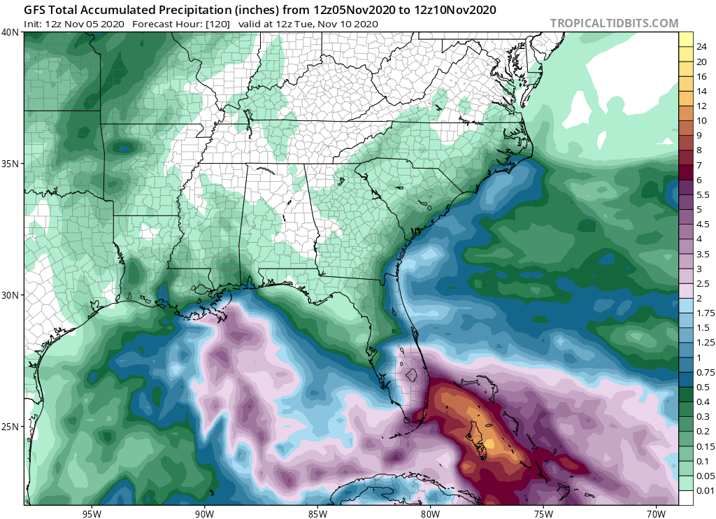
gatorcane wrote:Heaviest rainfall offshore and over the Bahamas:

https://i.postimg.cc/6pzmtgpy/gfs-apcpn-seus-20.png


That would be pretty ugly for Homestead though.
0 likes   
Andrew (1992), Irene (1999), Frances (2004), Katrina (2005), Wilma (2005), Fay (2008), Irma (2017), Eta (2020), Ian (2022)

User avatar
SFLcane
S2K Supporter
S2K Supporter
Posts: 10163
Age: 47
Joined: Sat Jun 05, 2010 1:44 pm
Location: Lake Worth Florida

Re: ATL: ETA - Models

#1169 Postby SFLcane » Thu Nov 05, 2020 11:26 am

Image
0 likes   

User avatar
SFLcane
S2K Supporter
S2K Supporter
Posts: 10163
Age: 47
Joined: Sat Jun 05, 2010 1:44 pm
Location: Lake Worth Florida

Re: ATL: ETA - Models

#1170 Postby SFLcane » Thu Nov 05, 2020 11:34 am

Trend north also on the gem...

Image
0 likes   

User avatar
Spacecoast
Category 2
Category 2
Posts: 758
Joined: Thu Aug 31, 2017 2:03 pm

Re: ATL: ETA - Models

#1171 Postby Spacecoast » Thu Nov 05, 2020 11:43 am

0z ECMF:...
Image
FSU (re-)genesis probability calculations are interesting this a.m.
Image
0 likes   

TheStormExpert

Re: ATL: ETA - Models

#1172 Postby TheStormExpert » Thu Nov 05, 2020 11:48 am


The NAVGEM brings a Cat.2 into Palm Beach.
:na:
0 likes   

User avatar
wxman57
Moderator-Pro Met
Moderator-Pro Met
Posts: 22978
Age: 67
Joined: Sat Jun 21, 2003 8:06 pm
Location: Houston, TX (southwest)

Re: ATL: ETA - Models

#1173 Postby wxman57 » Thu Nov 05, 2020 12:03 pm

Here's a website (Univ. of Albany) that has track and intensity verification for storms.

Eta: http://www.atmos.albany.edu/facstaff/tang/tcguidance/al292020/

Worst models for track are NGX/NOGAPS and the UKMET.

Image

HWRF is the big loser for intensity. EC is best at day 4, but only has one verification point.

Image
3 likes   

User avatar
CyclonicFury
Category 5
Category 5
Posts: 2025
Age: 26
Joined: Sun Jul 02, 2017 12:32 pm
Location: NC
Contact:

Re: ATL: ETA - Models

#1174 Postby CyclonicFury » Thu Nov 05, 2020 12:05 pm

wxman57 wrote:Here's a website (Univ. of Albany) that has track and intensity verification for storms.

Eta: http://www.atmos.albany.edu/facstaff/tang/tcguidance/al292020/

Worst models for track are NGX/NOGAPS and the UKMET.

http://wxman57.com/images/Etatrack.png

HWRF is the big loser for intensity. EC is best at day 4, but only has one verification point.

http://wxman57.com/images/Etaintensity.png

How is the HWRF a big loser for intensity, when it consistently showed Eta becoming a Category 4 hurricane before it formed while the Euro showed only a TS/weak C1?
2 likes   
NCSU B.S. in Meteorology Class of 2021. Tropical weather blogger at http://www.cyclonicfury.com. My forecasts and thoughts are NOT official, for official forecasts please consult the National Hurricane Center.

User avatar
Jr0d
S2K Supporter
S2K Supporter
Posts: 1409
Joined: Tue Aug 27, 2019 10:52 am
Location: Cayo Hueso

Re: ATL: ETA - Models

#1175 Postby Jr0d » Thu Nov 05, 2020 12:06 pm

TheStormExpert wrote:

The NAVGEM brings a Cat.2 into Palm Beach.
:na:


So Palm Beach wont get a direct hit from Eta....j/k sort of....

Tomorrow is ine of the few days I get to sleep in. When I wake up I will either start getting ready, secure loose items, fire up and fuel up the generator and get a few supplies that we dont already have OR not if the evolution of the system keeps it away from the Keys or shows a weak TS that wont be much of a threat.
0 likes   

TheStormExpert

Re: ATL: ETA - Models

#1176 Postby TheStormExpert » Thu Nov 05, 2020 12:09 pm

Jr0d wrote:
TheStormExpert wrote:

The NAVGEM brings a Cat.2 into Palm Beach.
:na:


So Palm Beach wont get a direct hit from Eta....j/k sort of....

Tomorrow is ine of the few days I get to sleep in. When I wake up I will either start getting ready, secure loose items, fire up and fuel up the generator and get a few supplies that we dont already have OR not if the evolution of the system keeps it away from the Keys or shows a weak TS that wont be much of a threat.

Usually when the NAVGEM shows it, it usually never happens.

Where about are you in South Florida?
0 likes   

AutoPenalti
Category 5
Category 5
Posts: 4030
Age: 29
Joined: Mon Aug 17, 2015 4:16 pm
Location: Ft. Lauderdale, Florida

Re: ATL: ETA - Models

#1177 Postby AutoPenalti » Thu Nov 05, 2020 12:13 pm

wxman57 wrote:Here's a website (Univ. of Albany) that has track and intensity verification for storms.

Eta: http://www.atmos.albany.edu/facstaff/tang/tcguidance/al292020/

Worst models for track are NGX/NOGAPS and the UKMET.

http://wxman57.com/images/Etatrack.png

HWRF is the big loser for intensity. EC is best at day 4, but only has one verification point.

http://wxman57.com/images/Etaintensity.png

Am I reading this wrong? HWRF seems to be quite the opposite of big loser. It's not the lowest but it's not the highest either..
0 likes   
The posts in this forum are NOT official forecasts and should not be used as such. They are just the opinion of the poster and may or may not be backed by sound meteorological data. They are NOT endorsed by any professional institution or STORM2K. For official information, please refer to products from the NHC and NWS.


Model Runs Cheat Sheet:
GFS (5:30 AM/PM, 11:30 AM/PM)
HWRF, GFDL, UKMET, NAVGEM (6:30-8:00 AM/PM, 12:30-2:00 AM/PM)
ECMWF (1:45 AM/PM)

TCVN
is a weighted averaged

MJGarrison
Tropical Storm
Tropical Storm
Posts: 146
Joined: Wed Aug 30, 2017 7:26 pm

Re: ATL: ETA - Models

#1178 Postby MJGarrison » Thu Nov 05, 2020 12:22 pm

AutoPenalti wrote:
wxman57 wrote:Here's a website (Univ. of Albany) that has track and intensity verification for storms.

Eta: http://www.atmos.albany.edu/facstaff/tang/tcguidance/al292020/

Worst models for track are NGX/NOGAPS and the UKMET.

http://wxman57.com/images/Etatrack.png

HWRF is the big loser for intensity. EC is best at day 4, but only has one verification point.

http://wxman57.com/images/Etaintensity.png

Am I reading this wrong? HWRF seems to be quite the opposite of big loser. It's not the lowest but it's not the highest either..

Wxman specifically was calling out Day 4


Sent from my iPad using Tapatalk
0 likes   

AutoPenalti
Category 5
Category 5
Posts: 4030
Age: 29
Joined: Mon Aug 17, 2015 4:16 pm
Location: Ft. Lauderdale, Florida

Re: ATL: ETA - Models

#1179 Postby AutoPenalti » Thu Nov 05, 2020 12:25 pm

MJGarrison wrote:
AutoPenalti wrote:
wxman57 wrote:Here's a website (Univ. of Albany) that has track and intensity verification for storms.

Eta: http://www.atmos.albany.edu/facstaff/tang/tcguidance/al292020/

Worst models for track are NGX/NOGAPS and the UKMET.

http://wxman57.com/images/Etatrack.png

HWRF is the big loser for intensity. EC is best at day 4, but only has one verification point.

http://wxman57.com/images/Etaintensity.png

Am I reading this wrong? HWRF seems to be quite the opposite of big loser. It's not the lowest but it's not the highest either..

Wxman specifically was calling out Day 4


Sent from my iPad using Tapatalk

Oh, the way he wrote it out I thought he was saying all 4 days.
0 likes   
The posts in this forum are NOT official forecasts and should not be used as such. They are just the opinion of the poster and may or may not be backed by sound meteorological data. They are NOT endorsed by any professional institution or STORM2K. For official information, please refer to products from the NHC and NWS.


Model Runs Cheat Sheet:
GFS (5:30 AM/PM, 11:30 AM/PM)
HWRF, GFDL, UKMET, NAVGEM (6:30-8:00 AM/PM, 12:30-2:00 AM/PM)
ECMWF (1:45 AM/PM)

TCVN
is a weighted averaged

User avatar
SFLcane
S2K Supporter
S2K Supporter
Posts: 10163
Age: 47
Joined: Sat Jun 05, 2010 1:44 pm
Location: Lake Worth Florida

Re: ATL: ETA - Models

#1180 Postby SFLcane » Thu Nov 05, 2020 12:27 pm

Image
0 likes   


Return to “2020”

Who is online

Users browsing this forum: No registered users and 4 guests