WeatherHoon wrote:This looks like it could catch Florida residents off guard.
It depends. We can handle a weak-moderate TS but anything stronger will catch people off guard.
Moderator: S2k Moderators
WeatherHoon wrote:This looks like it could catch Florida residents off guard.


TheStormExpert wrote:It looks like the sudden turn will happen in 72hrs. So depending on where Eta is then will determine if it makes landfall in Florida or not. The NHC has Eta still directly over Central Cuba in 72hrs. this the turn being further south.


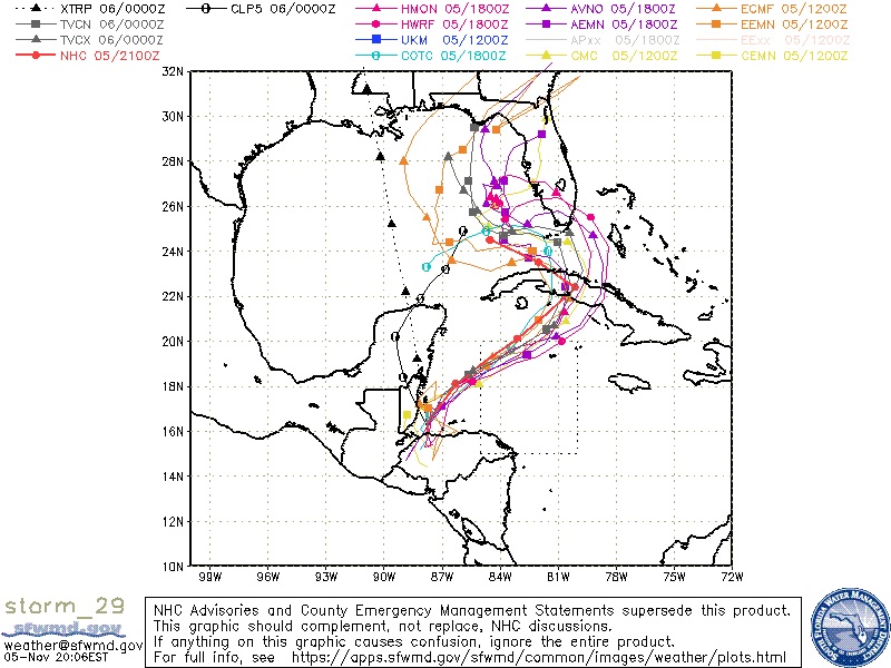
SFLcane wrote:Euro comes north heading NW on 18z!!
https://i.postimg.cc/GmYdnSLL/BAD50-BF3-521-D-47-B0-AFDC-365-C89-DDC585.jpg
Blown Away wrote:SFLcane wrote:Euro comes north heading NW on 18z!!
https://i.postimg.cc/GmYdnSLL/BAD50-BF3-521-D-47-B0-AFDC-365-C89-DDC585.jpg
Uh oh!!! That’s the last domino to fall... SFL Cat 1 may be in sight Sunday..


TheStormExpert wrote:WeatherHoon wrote:This looks like it could catch Florida residents off guard.
It depends. We can handle a weak-moderate TS but anything stronger will catch people off guard.
Weather Dude wrote:TheStormExpert wrote:WeatherHoon wrote:This looks like it could catch Florida residents off guard.
It depends. We can handle a weak-moderate TS but anything stronger will catch people off guard.
Anything can catch people off guard with the amount of rain forecast though
SFLcane wrote:Blown Away wrote:SFLcane wrote:Euro comes north heading NW on 18z!!
https://i.postimg.cc/GmYdnSLL/BAD50-BF3-521-D-47-B0-AFDC-365-C89-DDC585.jpg
Uh oh!!! That’s the last domino to fall... SFL Cat 1 may be in sight Sunday..
Yep here we go!
I will buy gas for the genny tomorrow, track record of that action has been fruitful for a very long timeKen711 wrote:SFLcane wrote:Blown Away wrote:
Uh oh!!! That’s the last domino to fall... SFL Cat 1 may be in sight Sunday..
Yep here we go!
Is the Florida force field that has protected it all season going to come to the rescue again.

jlauderdal wrote:I will buy gas for the genny tomorrow, track record of that action has been fruitful for a very long timeKen711 wrote:SFLcane wrote:
Yep here we go!
Is the Florida force field that has protected it all season going to come to the rescue again.
Frank2 wrote:I would not give the models much in the way confidence right now, because the 12z run showed very little in the way of excitment, but 6 hours later it shows a near-hurricane? Jumping back and forth does nothing or little for forecasters...
Others have said without a identifiable center the model data is of low confidence and I agree - the NHC might mention the change in the next package, but they might not, considering the shear...
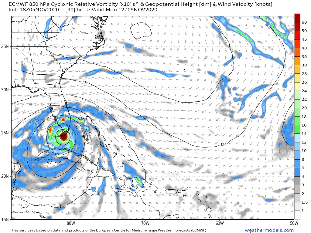
Spacecoast wrote:Levi: (As it it crosses Cuba), "..whether it gets strong, (or not),will depend on where it is in relation to this 'tongue' of dry air."
https://i.ibb.co/ZLb97sF/Capture114g.jpg

MetroMike wrote:Spacecoast wrote:Levi: (As it it crosses Cuba), "..whether it gets strong, (or not),will depend on where it is in relation to this 'tongue' of dry air."
https://i.ibb.co/ZLb97sF/Capture114g.jpg
Where did you see this post from Levi? no video out today or tweets?
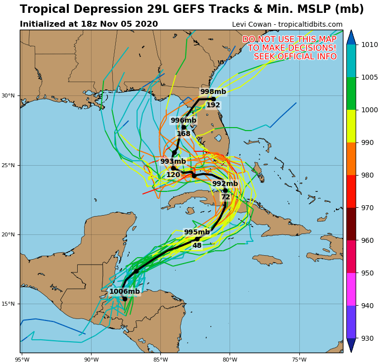
SFLcane wrote:Updated some 00z guidance...SFL you may have a problem
https://i.postimg.cc/RCpB6JXn/828-B1-C50-89-C9-4-CA0-BE88-C5-E78-AA863-C8.jpg
Ah, go ahead and call itAutoPenalti wrote:I’m waiting for 0z.
Then I can call off work on Monday
Users browsing this forum: No registered users and 10 guests

