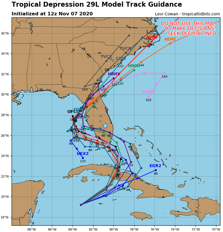
SFLcane wrote:06z gfs 987mb into dade county.
track different than oz though. cross west over to the west coast just offshore barely and riding up coast and second landfall pasco or hernando county to 993mb.
Moderator: S2k Moderators
SFLcane wrote:06z gfs 987mb into dade county.

SFLcane wrote:06z gfs 987mb into dade county.

jlauderdal wrote:SFLcane wrote:06z gfs 987mb into dade county.
its been consistent the last 24 hours....big rains on the way, power will be knocked out
that's what some say, they apparently forgot the difference between a thunderstorm and a tropical system that hangs around for a few days, sofla will be on the NE quadrant too which we haven't seen for a whilecrownweather wrote:jlauderdal wrote:SFLcane wrote:06z gfs 987mb into dade county.
its been consistent the last 24 hours....big rains on the way, power will be knocked out
But, hey it won't be any worse than a normal South Florida thunderstorm, right?
crownweather wrote:jlauderdal wrote:SFLcane wrote:06z gfs 987mb into dade county.
its been consistent the last 24 hours....big rains on the way, power will be knocked out
But, hey it won't be any worse than a normal South Florida thunderstorm, right?
jlauderdal wrote:that's what some say, they apparently forgot the difference between a thunderstorm and a tropical system that hangs around for a few days, sofla will be on the NE quadrant too which we haven't seen for a whilecrownweather wrote:jlauderdal wrote:its been consistent the last 24 hours....big rains on the way, power will be knocked out
But, hey it won't be any worse than a normal South Florida thunderstorm, right?
crownweather wrote:jlauderdal wrote:SFLcane wrote:06z gfs 987mb into dade county.
its been consistent the last 24 hours....big rains on the way, power will be knocked out
But, hey it won't be any worse than a normal South Florida thunderstorm, right?


TheStormExpert wrote:crownweather wrote:jlauderdal wrote:its been consistent the last 24 hours....big rains on the way, power will be knocked out
But, hey it won't be any worse than a normal South Florida thunderstorm, right?
A prolonged afternoon storm. The way some people are on here you’d think a formidable hurricane was bearing down on South Florida.
its not and anyone that says it is doesn't know what they are talking about...I was in zeta last week in NC, lost power in winds under 50, trees were knocked down..furthermore, one big gust in convection will do itWeather Dude wrote:TheStormExpert wrote:crownweather wrote:
But, hey it won't be any worse than a normal South Florida thunderstorm, right?
A prolonged afternoon storm. The way some people are on here you’d think a formidable hurricane was bearing down on South Florida.
I guess I'll just never understand how a 60-70 mph TS that floods many areas and dumps 15-20+ inches of rain is a typical summer storm...

Weather Dude wrote:TheStormExpert wrote:crownweather wrote:
But, hey it won't be any worse than a normal South Florida thunderstorm, right?
A prolonged afternoon storm. The way some people are on here you’d think a formidable hurricane was bearing down on South Florida.
I guess I'll just never understand how a 60-70 mph TS that floods many areas and dumps 15-20+ inches of rain is a typical summer storm...

gatorcane wrote:Weather Dude wrote:TheStormExpert wrote:A prolonged afternoon storm. The way some people are on here you’d think a formidable hurricane was bearing down on South Florida.
I guess I'll just never understand how a 60-70 mph TS that floods many areas and dumps 15-20+ inches of rain is a typical summer storm...
What model is showing that much rain? The GFS which has the storm right over South Florida shows 4-5 inches at most for most of the area but not 15-20 inches.
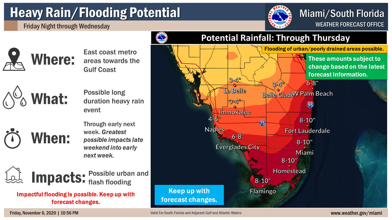
SFLcane wrote:gatorcane wrote:Weather Dude wrote:I guess I'll just never understand how a 60-70 mph TS that floods many areas and dumps 15-20+ inches of rain is a typical summer storm...
What model is showing that much rain? The GFS which has the storm right over South Florida shows 4-5 inches at most for most of the area but not 15-20 inches.
4/5 inches? Folks stick to the official forecast which is near 10 inches.
https://i.postimg.cc/1R7DrvnM/6-F8-F48-F8-C41-F-4-B78-8-DB4-02-ABF0708037.jpg
SFLcane wrote:gatorcane wrote:Weather Dude wrote:I guess I'll just never understand how a 60-70 mph TS that floods many areas and dumps 15-20+ inches of rain is a typical summer storm...
What model is showing that much rain? The GFS which has the storm right over South Florida shows 4-5 inches at most for most of the area but not 15-20 inches.
4/5 inches? Folks PLEASE stick to the official forecast which is near 10 inches instead of following individual model runs every 4-6hrs.
https://i.postimg.cc/1R7DrvnM/6-F8-F48-F8-C41-F-4-B78-8-DB4-02-ABF0708037.jpg
Users browsing this forum: No registered users and 62 guests