ClarCari wrote:NHC now has Iota a Cat.2 to 100mph. Quite the jump from current recon data but understandable as this thing isn’t plateauing anytime soon. Forecast peak remains the same..for now.
The intermediate advisory does not have discussions.
Moderator: S2k Moderators


ClarCari wrote:NHC now has Iota a Cat.2 to 100mph. Quite the jump from current recon data but understandable as this thing isn’t plateauing anytime soon. Forecast peak remains the same..for now.

Ryxn wrote:It's mid-November for Pete's sake. If it can reach that crazy Category 5 past midnight tonight, it would mean there would be a Category 5 closer to DECEMBER than October. That would be some next level stuff. Very 2020 tho...
Iceresistance wrote:ClarCari wrote:NHC now has Iota a Cat.2 to 100mph. Quite the jump from current recon data but understandable as this thing isn’t plateauing anytime soon. Forecast peak remains the same..for now.
The intermediate advisory does not have discussions.
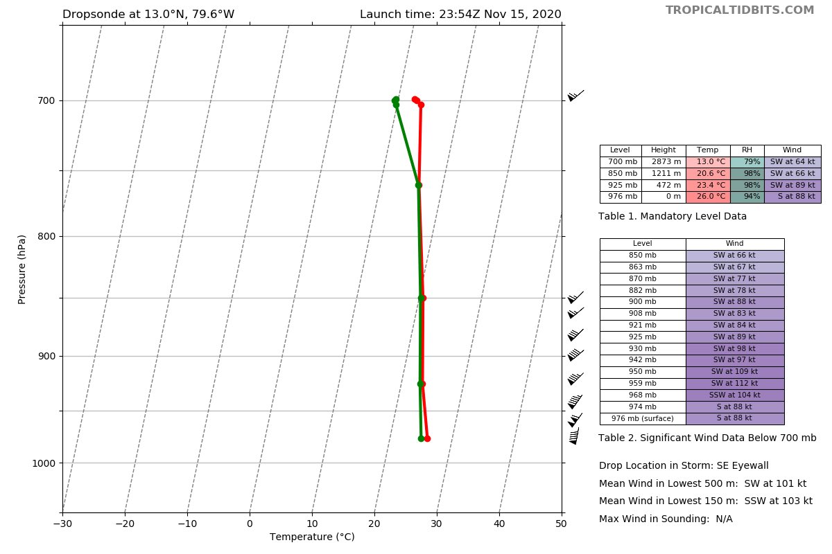
Iceresistance wrote:964 MB
https://www.tropicaltidbits.com/recon/recon_AF305-0431A-IOTA_dropsonde2_20201115-2251.png
hipshot wrote:Iceresistance wrote:964 MB
https://www.tropicaltidbits.com/recon/recon_AF305-0431A-IOTA_dropsonde2_20201115-2251.png
I see these plots all the time, what is the difference between the red and green lines?


Iceresistance wrote:hipshot wrote:Iceresistance wrote:964 MB
https://www.tropicaltidbits.com/recon/recon_AF305-0431A-IOTA_dropsonde2_20201115-2251.png
I see these plots all the time, what is the difference between the red and green lines?
The red lines are the wind speed, & the green lines are the humidity, there are details about it to the right on the data sheet.
kevin wrote:New pass 959.4 mbar, 2.8 mbar drop in about one hour.


NDG wrote:Cunxi Huang wrote:https://twitter.com/wxtrackercody/status/1328128065742934017
This kid has no idea.

NDG wrote:Cunxi Huang wrote:https://twitter.com/wxtrackercody/status/1328128065742934017
This kid has no idea.
Users browsing this forum: No registered users and 107 guests


