Texas Winter 2020-2021

Winter Weather Discussion

Moderator: S2k Moderators

Forum rules

The posts in this forum are NOT official forecast and should not be used as such. They are just the opinion of the poster and may or may not be backed by sound meteorological data. They are NOT endorsed by any professional institution or STORM2K.

Help Support Storm2K
Message
Author
User avatar
TheProfessor
Professional-Met
Professional-Met
Posts: 3506
Age: 28
Joined: Tue Dec 03, 2013 10:56 am
Location: Wichita, Kansas

Re: Texas Winter 2020-2021

#2241 Postby TheProfessor » Fri Jan 22, 2021 12:44 pm

Iceresistance wrote:
TheProfessor wrote:
Iceresistance wrote:
All of this is true, but that sounding is showing if no other storms already went over that area.

Yes, the threat will be lower if there is too much clouds, previous storms, less wind shear, less CAPE & if the area is capped.

But, there is always a chance that the cap breaks & ruptures (When a storm breaks the cap, it can rupture & allow more storms to form, this happened last year when a powerful supercell broke the cap & more storms followed suit afterword) and chances can't be taken with convective activity because they are very unpredictable on how strong they can be & can suddenly change direction.


I'm telling you that the sounding you posted is contaminated, the dewpoint being right on the temperature line near the surface and the temperature inversion both suggests this. The 12z GFS at this moment also shows precipitation over Dallas at that moment. That's what is causing the contamination. This means that we can't really get a good gage on what the sounding you posted is telling us because it's being affected by ongoing precipitation. In this case the rain is causing a temperature inversion, which lessens the parameters for severe weather on a sounding.

If the opposite were true and the sounding wasn't contaminated then the severe weather risk would be minimalized because of the temperature inversion at the surface and weak low level lapse rates (caused by the inversion.).


Oh, I see now

https://s2.gifyu.com/images/gfs_mslp_pcpn_frzn_scus_fh60-60.gif

When a Sounding is looking crazy, double-check the radar to see if it is a contaminated sounding, if it is (Example above), then the true threat is lower. But if it is not, the unthinkable may happen.


No, you can get a crazy sounding without it being contaminated. A contaminated sounding just means that the atmosphere has been contaminated (by rain) and the sounding is usually overly saturated. In Peak spring this may not even result in a temperature inversion, but the low level dewpoint depression will be obvious (and near zero). In the case of peak Spring, having a saturated sounding can still show a more limited event as you typically want midlevel dry air (around the 700mb level) and above during a severe weather even. So in most cases a contaminated sounding will actually result in showing a more limited event than a crazy one. If a contaminated sounding is showing the possibility of a high end event, then it's likely if the sounding wasn't contaminated it would show something even more severe.
2 likes   
An alumnus of The Ohio State University.

Your local National Weather Service office is your best source for weather information.

User avatar
Iceresistance
Category 5
Category 5
Posts: 9288
Age: 21
Joined: Sat Oct 10, 2020 9:45 am
Location: Tecumseh, OK/Norman, OK

Re: Texas Winter 2020-2021

#2242 Postby Iceresistance » Fri Jan 22, 2021 12:47 pm

TheProfessor wrote:
Iceresistance wrote:
TheProfessor wrote:
I'm telling you that the sounding you posted is contaminated, the dewpoint being right on the temperature line near the surface and the temperature inversion both suggests this. The 12z GFS at this moment also shows precipitation over Dallas at that moment. That's what is causing the contamination. This means that we can't really get a good gage on what the sounding you posted is telling us because it's being affected by ongoing precipitation. In this case the rain is causing a temperature inversion, which lessens the parameters for severe weather on a sounding.

If the opposite were true and the sounding wasn't contaminated then the severe weather risk would be minimalized because of the temperature inversion at the surface and weak low level lapse rates (caused by the inversion.).


Oh, I see now

https://s2.gifyu.com/images/gfs_mslp_pcpn_frzn_scus_fh60-60.gif

When a Sounding is looking crazy, double-check the radar to see if it is a contaminated sounding, if it is (Example above), then the true threat is lower. But if it is not, the unthinkable may happen.


No, you can get a crazy sounding without it being contaminated. A contaminated sounding just means that the atmosphere has been contaminated (by rain) and the sounding is usually overly saturated. In Peak spring this may not even result in a temperature inversion, but the low level dewpoint depression will be obvious (and near zero). In the case of peak Spring, having a saturated sounding can still show a more limited event as you typically want midlevel dry air (around the 700mb level) and above during a severe weather even. So in most cases a contaminated sounding will actually result in showing a more limited event than a crazy one. If a contaminated sounding is showing the possibility of a high end event, then it's likely if the sounding wasn't contaminated it would show something even more severe.


True, there were a LOT of crazy soundings in 2019, especially in Oklahoma. And that led to the High Risk in May.
0 likes   
Bill 2015 & Beta 2020

Winter 2020-2021 :cold:

All observations are in Tecumseh, OK unless otherwise noted.

Winter posts are focused mainly for Oklahoma & Texas.

Take any of my forecasts with a grain of salt, refer to the NWS, SPC, and NHC for official information

Never say Never with weather! Because ANYTHING is possible!

Brent
S2K Supporter
S2K Supporter
Posts: 38088
Age: 36
Joined: Sun May 16, 2004 10:30 pm
Location: Tulsa Oklahoma
Contact:

Re: Texas Winter 2020-2021

#2243 Postby Brent » Sat Jan 23, 2021 1:06 am

Winter returns in February? :spam:
Image
3 likes   
#neversummer

User avatar
Cerlin
Category 5
Category 5
Posts: 1182
Age: 23
Joined: Thu Dec 08, 2016 12:06 am
Location: Norman, OK

Re: Texas Winter 2020-2021

#2244 Postby Cerlin » Sat Jan 23, 2021 1:10 am

Brent wrote:Winter returns in February? :spam:
https://i.ibb.co/5FJKvDK/gfs-asnow-scus-55.png

GFS has been showing a cold shot there for a few runs now. Could potentially be a return to winter!
2 likes   
Graduate Meteorology Student at the University of Oklahoma!
All opinions independent of employers and the university.

User avatar
somethingfunny
ChatStaff
ChatStaff
Posts: 3926
Age: 37
Joined: Thu May 31, 2007 10:30 pm
Location: McKinney, Texas

Re: Texas Winter 2020-2021

#2245 Postby somethingfunny » Sat Jan 23, 2021 1:22 am

Anecdotally speaking, our winter snow season really is just the first and second weeks of February. So glad it's coming into range and we at least have a cold dump possible for it
2 likes   
I am not a meteorologist, and any posts made by me are not official forecasts or to be interpreted as being intelligent. These posts are just my opinions and are probably silly opinions.

gpsnowman
S2K Supporter
S2K Supporter
Posts: 3185
Joined: Fri Jan 07, 2011 10:35 am
Location: Grand Prairie Tx

Re: Texas Winter 2020-2021

#2246 Postby gpsnowman » Sat Jan 23, 2021 6:21 am

Nice to see a good sign this early a.m. I'm sure the big snow hole over Oklahoma will fill in quite nicely. :cry:
1 likes   

User avatar
bubba hotep
S2K Supporter
S2K Supporter
Posts: 5837
Joined: Wed Dec 28, 2016 1:00 am
Location: Collin County Texas

Re: Texas Winter 2020-2021

#2247 Postby bubba hotep » Sat Jan 23, 2021 2:46 pm

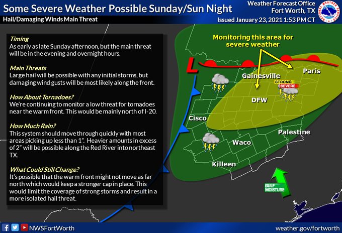
Slight risk for tomorrow mostly for a hail threat.

Image
1 likes   
Winter time post are almost exclusively focused on the DFW area.

User avatar
bubba hotep
S2K Supporter
S2K Supporter
Posts: 5837
Joined: Wed Dec 28, 2016 1:00 am
Location: Collin County Texas

Re: Texas Winter 2020-2021

#2248 Postby bubba hotep » Sat Jan 23, 2021 2:51 pm

Some signs showing up in the longer range ensembles that the Pacific jet retraction / pattern retrograde will be temporary and colder conditions should return to Texas by the 2nd week of February. This is consistent with some of the SSW analogs that showed a significant lag in the cold response over N. America following the SSW event.
5 likes   
Winter time post are almost exclusively focused on the DFW area.

User avatar
vbhoutex
Storm2k Executive
Storm2k Executive
Posts: 29112
Age: 73
Joined: Wed Oct 09, 2002 11:31 pm
Location: Cypress, TX
Contact:

Re: Texas Winter 2020-2021

#2249 Postby vbhoutex » Sat Jan 23, 2021 4:38 pm

Brent wrote:Winter returns in February? :spam:
https://i.ibb.co/5FJKvDK/gfs-asnow-scus-55.png

That snow needs to move a few more counties South for Houston proper to get any. Teaser :froze: :spam:
2 likes   
Skywarn, C.E.R.T.
Please click below to donate to STORM2K to help with the expenses of keeping the site going:
Image

gpsnowman
S2K Supporter
S2K Supporter
Posts: 3185
Joined: Fri Jan 07, 2011 10:35 am
Location: Grand Prairie Tx

Re: Texas Winter 2020-2021

#2250 Postby gpsnowman » Sat Jan 23, 2021 6:07 pm

Winter or not thunderstorms are always great. An overnight event for most but I hope I wake early enough Monday to witness the skinny line.
3 likes   

TexasBreeze
Tropical Depression
Tropical Depression
Posts: 81
Joined: Mon Jul 07, 2014 12:50 pm

Re: Texas Winter 2020-2021

#2251 Postby TexasBreeze » Sat Jan 23, 2021 6:14 pm

Looks like Lake Charles can see what comes from southeast Texas and surrounding areas on the LCH radar again since repairs are finished from Hurricane Laura. Good thing ahead of storm season and the next hurricane season.

https://www.weather.gov/news/012221-lake-charles-radar
3 likes   

User avatar
bubba hotep
S2K Supporter
S2K Supporter
Posts: 5837
Joined: Wed Dec 28, 2016 1:00 am
Location: Collin County Texas

Re: Texas Winter 2020-2021

#2252 Postby bubba hotep » Sat Jan 23, 2021 7:10 pm

Image
1 likes   
Winter time post are almost exclusively focused on the DFW area.

User avatar
bubba hotep
S2K Supporter
S2K Supporter
Posts: 5837
Joined: Wed Dec 28, 2016 1:00 am
Location: Collin County Texas

Re: Texas Winter 2020-2021

#2253 Postby bubba hotep » Sun Jan 24, 2021 9:53 am

bubba hotep wrote:
DonWrk wrote:Go from exciting times to doom and gloom just like that :x Gotta love it.


This isn't getting anyone hyped lol

Image


GEFS and Euro EPS are in pretty good agreement that things won't get as bad as the models were showing last week. In fact, the pattern flips back pretty quickly and I wouldn't be surprised to see some winter wx threats showing up beyond the 7 - 10 day range.

Image
7 likes   
Winter time post are almost exclusively focused on the DFW area.

HockeyTx82
S2K Supporter
S2K Supporter
Posts: 2540
Joined: Tue Oct 27, 2009 11:17 am
Location: Ponder, TX

Re: Texas Winter 2020-2021

#2254 Postby HockeyTx82 » Sun Jan 24, 2021 1:12 pm

Will all this fog hanging around and lack of heating reduce the severe threat later? It's 55 and misting with fog here still right now.
1 likes   
Don't hold me accountable for anything I post on this forum. Leave the real forecasting up to the professionals.

Location: Ponder, TX (all observation posts are this location unless otherwise noted)

gpsnowman
S2K Supporter
S2K Supporter
Posts: 3185
Joined: Fri Jan 07, 2011 10:35 am
Location: Grand Prairie Tx

Re: Texas Winter 2020-2021

#2255 Postby gpsnowman » Sun Jan 24, 2021 1:21 pm

HockeyTx82 wrote:Will all this fog hanging around and lack of heating reduce the severe threat later? It's 55 and misting with fog here still right now.

A warm front is due later this afternoon with the first round of storms. It should start warming up during this time. It's still pretty cool oitside so it will have to warm up quickly. Then a cold front blows in overnight triggering the severe potential.
0 likes   

HockeyTx82
S2K Supporter
S2K Supporter
Posts: 2540
Joined: Tue Oct 27, 2009 11:17 am
Location: Ponder, TX

Re: Texas Winter 2020-2021

#2256 Postby HockeyTx82 » Sun Jan 24, 2021 1:49 pm

gpsnowman wrote:
HockeyTx82 wrote:Will all this fog hanging around and lack of heating reduce the severe threat later? It's 55 and misting with fog here still right now.

A warm front is due later this afternoon with the first round of storms. It should start warming up during this time. It's still pretty cool oitside so it will have to warm up quickly. Then a cold front blows in overnight triggering the severe potential.


Got it, guess just wait and see
0 likes   
Don't hold me accountable for anything I post on this forum. Leave the real forecasting up to the professionals.

Location: Ponder, TX (all observation posts are this location unless otherwise noted)

User avatar
cheezyWXguy
Category 5
Category 5
Posts: 6108
Joined: Mon Feb 13, 2006 12:29 am
Location: Dallas, TX

Re: Texas Winter 2020-2021

#2257 Postby cheezyWXguy » Sun Jan 24, 2021 2:00 pm

The parameter space looks interesting just ahead of the line on hrrr tonight with srh near 400, but it doesn’t do much in terms of producing storms near dfw. Nam isn’t very enthusiastic either, but if the line is potent, I wouldn’t be too surprised to see a qlcs spin up or two somewhere in ntx, probably south of the metro.
1 likes   

User avatar
TheProfessor
Professional-Met
Professional-Met
Posts: 3506
Age: 28
Joined: Tue Dec 03, 2013 10:56 am
Location: Wichita, Kansas

Re: Texas Winter 2020-2021

#2258 Postby TheProfessor » Sun Jan 24, 2021 3:09 pm

SREF SigTor really likes the triple point for this event, could be interesting near the low pressure.
0 likes   
An alumnus of The Ohio State University.

Your local National Weather Service office is your best source for weather information.

HockeyTx82
S2K Supporter
S2K Supporter
Posts: 2540
Joined: Tue Oct 27, 2009 11:17 am
Location: Ponder, TX

Re: Texas Winter 2020-2021

#2259 Postby HockeyTx82 » Sun Jan 24, 2021 3:50 pm

TheProfessor wrote:SREF SigTor really likes the triple point for this event, could be interesting near the low pressure.


Timing and location? What are you seeing exactly?
0 likes   
Don't hold me accountable for anything I post on this forum. Leave the real forecasting up to the professionals.

Location: Ponder, TX (all observation posts are this location unless otherwise noted)

User avatar
TheProfessor
Professional-Met
Professional-Met
Posts: 3506
Age: 28
Joined: Tue Dec 03, 2013 10:56 am
Location: Wichita, Kansas

Re: Texas Winter 2020-2021

#2260 Postby TheProfessor » Sun Jan 24, 2021 3:58 pm

HockeyTx82 wrote:
TheProfessor wrote:SREF SigTor really likes the triple point for this event, could be interesting near the low pressure.


Timing and location? What are you seeing exactly?


If the SREF is to be believed, then the best parameters would be north and west of DFW around midnight through 6 AM. The question is if there will actually be discrete or semi-discrete storms that could take advantage. If the low ends up further south or southeast then everything would shift closer to DFW.
1 likes   
An alumnus of The Ohio State University.

Your local National Weather Service office is your best source for weather information.


Return to “Winter Weather”

Who is online

Users browsing this forum: No registered users and 7 guests