
ATL: ELSA - Post-Tropical - Discussion
Moderator: S2k Moderators
-
AveryTheComrade
- Tropical Depression

- Posts: 76
- Joined: Fri Jul 10, 2020 9:19 pm
Re: ATL: ELSA - Hurricane - Discussion
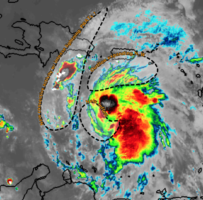
Elsa still seems very decoupled, there's clearly some circulation here but evidently it isn't the center since convection isn't following it. Not sure what's going on.
4 likes
-
Sciencerocks
- Category 5

- Posts: 10186
- Age: 40
- Joined: Thu Jul 06, 2017 1:51 am

-
Shell Mound
- Category 5
- Posts: 2432
- Age: 33
- Joined: Thu Sep 07, 2017 3:39 pm
- Location: St. Petersburg, FL → Scandinavia
Re: ATL: ELSA - Hurricane - Discussion
Sciencerocks wrote:https://imagizer.imageshack.com/img924/9955/9OvoeH.gif
Could the LLC reform closer to the convection (MLC), or are the low-level trades too strong for such an outcome? Outflow is improving on the western side.
https://twitter.com/AndyHazelton/status/1411154801602306054
https://twitter.com/mikeremaley1/status/1411156619786952704
https://twitter.com/cyclonicwx/status/1411157177914511362
https://twitter.com/AndyHazelton/status/1411157564675575808
https://twitter.com/JackKipnis19/status/1411157279211200517
2 likes
CVW / MiamiensisWx / Shell Mound
The posts in this forum are NOT official forecasts and should not be used as such. They are just the opinion of the poster and may or may not be backed by sound meteorological data. They are NOT endorsed by any professional institution or STORM2K. For official information, please refer to products from the NHC and NWS.
-
NXStumpy_Robothing
- Category 1

- Posts: 335
- Age: 25
- Joined: Fri Jun 05, 2020 11:50 pm
- Location: North Georgia
Re: ATL: ELSA - Hurricane - Discussion
AveryTheComrade wrote:Elsa still seems very decoupled, there's clearly some circulation here but evidently it isn't the center since convection isn't following it. Not sure what's going on.
https://cdn.discordapp.com/attachments/619419338151034911/860783659770445844/unknown.png
From what I can tell, I believe that convection is associated with the potent mid-level center, as it matches up with long-range radar reflectivity returns from Puerto Rico. I think the naked circulation to the WNW is the weakening low-level center, which is being ejected in that direction after potentially decoupling with the MLC. Either the convection manages to catch it, or it slowly winds down and is absorbed by the new dominant circulation to the SE. Also, should be noted that I could be way off with this line of thinking, and the next 12 hours prior to recon show the need for me to eat a shoe.
Going to need to watch to see if this convection sustains and begins to rotate, allowing the MLC to burrow to the surface and create a new, vertically stacked center of circulation. If so, then I think more intense model solutions could come into play as Elsa approaches the SW edge of Hispaniola and the Jamaica Channel.
5 likes
Undergraduate Meteorology Student, Georgia Institute of Technology
-
Shell Mound
- Category 5
- Posts: 2432
- Age: 33
- Joined: Thu Sep 07, 2017 3:39 pm
- Location: St. Petersburg, FL → Scandinavia
Re: ATL: ELSA - Hurricane - Discussion
NXStumpy_Robothing wrote:AveryTheComrade wrote:Elsa still seems very decoupled, there's clearly some circulation here but evidently it isn't the center since convection isn't following it. Not sure what's going on.
https://cdn.discordapp.com/attachments/619419338151034911/860783659770445844/unknown.png
From what I can tell, I believe that convection is associated with the potent mid-level center, as it matches up with long-range radar reflectivity returns from Puerto Rico. I think the naked circulation to the WNW is the weakening low-level center, which is being ejected in that direction after potentially decoupling with the MLC. Either the convection manages to catch it, or it slowly winds down and is absorbed by the new dominant circulation to the SE. Also, should be noted that I could be way off with this line of thinking, and the next 12 hours prior to recon show the need for me to eat a shoe.
Going to need to watch to see if this convection sustains and begins to rotate, allowing the MLC to burrow to the surface and create a new, vertically stacked center of circulation. If so, then I think more intense model solutions could come into play as Elsa approaches the SW edge of Hispaniola and the Jamaica Channel.
6 likes
CVW / MiamiensisWx / Shell Mound
The posts in this forum are NOT official forecasts and should not be used as such. They are just the opinion of the poster and may or may not be backed by sound meteorological data. They are NOT endorsed by any professional institution or STORM2K. For official information, please refer to products from the NHC and NWS.

Re: ATL: ELSA - Hurricane - Discussion
Elsa is looking better this past hour in my opinion...but has a long way to go for the 12Z HWRF to verify in less than four hours....
It might be just an illusion and my confirmation bias(believing the HWRF) is clouding my judgement...less than an hour 7ntil the next NHC discussion. I'll be up watching every new satellite image until then.
It might be just an illusion and my confirmation bias(believing the HWRF) is clouding my judgement...less than an hour 7ntil the next NHC discussion. I'll be up watching every new satellite image until then.
4 likes
Re: ATL: ELSA - Hurricane - Discussion
Recon is en route from Homestead. Unfortunately I will be asleep when they get to Elsa.
There is no doubt in my mind Elsa has weakened to a storm....but the NHC will not downgrade until.recon verifies this.
If the current trend continues( deep convection at the core, expanding outflow, ect ..) it will be a hurricane again by the time recon gets there.
Kind of pointless to downgrade based off scanty evidence when the potential to restrengthen quickly is there.
4 likes
-
Shell Mound
- Category 5
- Posts: 2432
- Age: 33
- Joined: Thu Sep 07, 2017 3:39 pm
- Location: St. Petersburg, FL → Scandinavia
Re: ATL: ELSA - Hurricane - Discussion
Shell Mound wrote:NXStumpy_Robothing wrote:AveryTheComrade wrote:Elsa still seems very decoupled, there's clearly some circulation here but evidently it isn't the center since convection isn't following it. Not sure what's going on.
https://cdn.discordapp.com/attachments/619419338151034911/860783659770445844/unknown.png
From what I can tell, I believe that convection is associated with the potent mid-level center, as it matches up with long-range radar reflectivity returns from Puerto Rico. I think the naked circulation to the WNW is the weakening low-level center, which is being ejected in that direction after potentially decoupling with the MLC. Either the convection manages to catch it, or it slowly winds down and is absorbed by the new dominant circulation to the SE. Also, should be noted that I could be way off with this line of thinking, and the next 12 hours prior to recon show the need for me to eat a shoe.
Going to need to watch to see if this convection sustains and begins to rotate, allowing the MLC to burrow to the surface and create a new, vertically stacked center of circulation. If so, then I think more intense model solutions could come into play as Elsa approaches the SW edge of Hispaniola and the Jamaica Channel.
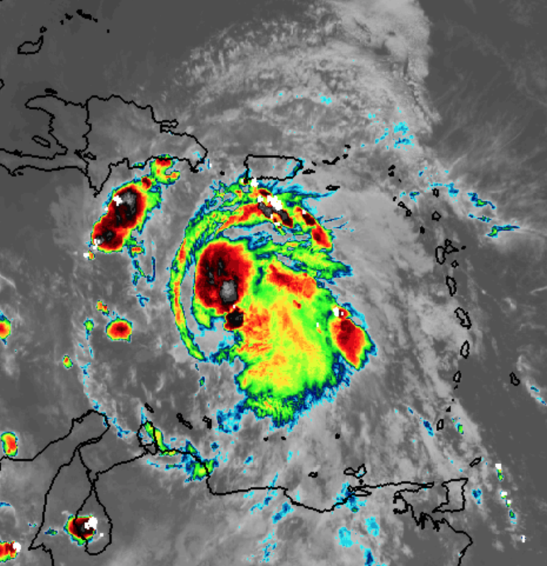
Based on continuing trends, I think a reformation of the centre to the southeast is becoming increasingly plausible. Future packages may adjust MSW upward.
5 likes
CVW / MiamiensisWx / Shell Mound
The posts in this forum are NOT official forecasts and should not be used as such. They are just the opinion of the poster and may or may not be backed by sound meteorological data. They are NOT endorsed by any professional institution or STORM2K. For official information, please refer to products from the NHC and NWS.

Re: ATL: ELSA - Hurricane - Discussion
Shell Mound wrote:Shell Mound wrote:NXStumpy_Robothing wrote:From what I can tell, I believe that convection is associated with the potent mid-level center, as it matches up with long-range radar reflectivity returns from Puerto Rico. I think the naked circulation to the WNW is the weakening low-level center, which is being ejected in that direction after potentially decoupling with the MLC. Either the convection manages to catch it, or it slowly winds down and is absorbed by the new dominant circulation to the SE. Also, should be noted that I could be way off with this line of thinking, and the next 12 hours prior to recon show the need for me to eat a shoe.
Going to need to watch to see if this convection sustains and begins to rotate, allowing the MLC to burrow to the surface and create a new, vertically stacked center of circulation. If so, then I think more intense model solutions could come into play as Elsa approaches the SW edge of Hispaniola and the Jamaica Channel.
https://i.postimg.cc/7YHvPff4/Elsa2021-7.png
https://i.postimg.cc/0yS6Ckqz/Ska-rmavbild-2021-07-03-kl-11-16-56.png
Based on continuing trends, I think a reformation of the centre to the southeast is becoming increasingly plausible. Future packages may adjust MSW upward.
This might be worrisome in terms of long-term intensity right as a centre reformation to the south could help Elsa to prevent land interaction with Hispaniola. Or is the east component of the centre reformation enough to compensate for the southern shift?
1 likes
-
AlphaToOmega
- Category 5
- Posts: 1448
- Joined: Sat Jun 26, 2021 10:51 am
- Location: Somewhere in Massachusetts
Re: ATL: ELSA - Hurricane - Discussion
The big question is the path of Hurricane Elsa. If Elsa dodges the islands, it can intensify. If Elsa interacts with the islands, it will weaken. The NHC acknowledges this in its forecast:
Some mid-level wind shear associated with Elsa's fast forward speed
appears to be affecting the hurricane now. However, since the
cyclone is expected to slow down and move beneath an upper-level
anticyclone later this weekend, it seems likely that the vortex will
become better aligned in the vertical. The big question is will
Elsa be interacting with the mountainous islands of Hispaniola and
Cuba when the environmental winds become conducive for
strengthening. If the cyclone manages to stay south of those
islands, Elsa could have an opportunity to restrengthen. Conversely,
if the storm tracks directly over the islands, weakening would very
likely occur. As a compromise, the NHC intensity forecast shows
little change in strength through tonight, followed by slow
weakening on Sunday and early Monday. Slight restrengthening is
forecast when Elsa moves north of Cuba and across the eastern Gulf
of Mexico. This forecast is a little lower than the previous one in
the short term, but is largely unchanged at the longer forecast
times.
2 likes

Re: ATL: ELSA - Hurricane - Discussion
aspen wrote:I wonder what kind of storm I’ll wake up to tomorrow morning. A recovering hurricane? Decaying slop? Or something like what we’re seeing now?
Decaying slop it is. Seems like the HWRF has finally busted in its usually very accurate short-term forecast.
Last edited by aspen on Sat Jul 03, 2021 5:15 am, edited 1 time in total.
0 likes
Irene '11 Sandy '12 Hermine '16 5/15/2018 Derecho Fay '20 Isaias '20 Elsa '21 Henri '21 Ida '21
I am only a meteorology enthusiast who knows a decent amount about tropical cyclones. Look to the professional mets, the NHC, or your local weather office for the best information.
I am only a meteorology enthusiast who knows a decent amount about tropical cyclones. Look to the professional mets, the NHC, or your local weather office for the best information.
-
HurricaneFrances04
- Category 2

- Posts: 597
- Joined: Mon Jun 25, 2012 8:09 am
- Location: Fort Lauderdale, Florida
Re: ATL: ELSA - Hurricane - Discussion
The center looks completely exposed this morning. Hard to believe the HWRF will come close to verifying.
0 likes
-
Shell Mound
- Category 5
- Posts: 2432
- Age: 33
- Joined: Thu Sep 07, 2017 3:39 pm
- Location: St. Petersburg, FL → Scandinavia
Re: ATL: ELSA - Hurricane - Discussion
xironman wrote:Looks seriously decoupled. Euro win?
The ECMWF, which failed to show Elsa as a hurricane and continues to incorrectly initialise the system, just caved to the GFS et al. and now shows a stronger Elsa tracking into the west coast of peninsular FL. So I wouldn’t call the current setup a “win” for the ECMWF. As for the old LLC, it seems likely to dissipate and reform closer to the convection, given that mid-level shear is evidently decreasing, albeit gradually. Latest imagery indicates that hot towers are continuing to proliferate well to the southeast of the old, exposed LLC. If the centre reforms, the HWRF could still end up the winner in terms of intensity, given a more southerly LLC with more time over water.
1 likes
CVW / MiamiensisWx / Shell Mound
The posts in this forum are NOT official forecasts and should not be used as such. They are just the opinion of the poster and may or may not be backed by sound meteorological data. They are NOT endorsed by any professional institution or STORM2K. For official information, please refer to products from the NHC and NWS.
Re: ATL: ELSA - Hurricane - Discussion
cane5 wrote:I have to say without storm2k and the amazing contributions Hurricane season would be far less predictable. Hard to give thoughts when you see the depth and understanding posters have here measures up to the best of the stock boards I go to.
I am a native of Miami 65 years and there were the famous 3 Hurricanes Donna, Betsy and Cleo all in a row anyone remember those days ?
Yup!
Been there,’seen those!
See my sig line.
0 likes
Cleo - 1964, Betsy - 1965, David - 1979, Andrew - 1992, Charlie (Francis, Ivan, Jeanne) - 2004, Irma - 2017, Ian - 2022, Milton - 2024
Re: ATL: ELSA - Hurricane - Discussion
cane5 wrote:If you live in South Florida I have been watching the weather guy on Channel 6 at 5pm…he is really on the ball when it comes to big storm systems , very impressed.
What’s the call letters?
I can probably find him on their web site.
We used to have a guy like that on the west coast. In fact, he was the FIRST met to make the call that Charley WASNT going to Tampa when he saw that jog to the east. That prompted us to hurry our boarding up.
0 likes
Cleo - 1964, Betsy - 1965, David - 1979, Andrew - 1992, Charlie (Francis, Ivan, Jeanne) - 2004, Irma - 2017, Ian - 2022, Milton - 2024
-
jlauderdal
- S2K Supporter

- Posts: 7240
- Joined: Wed May 19, 2004 5:46 am
- Location: NE Fort Lauderdale
- Contact:
Re: ATL: ELSA - Hurricane - Discussion
xironman wrote:Looks seriously decoupled. Euro win?
The euro was a bust for this system early on, now if you want to start over from today then that's a different discussion
4 likes

Re: ATL: ELSA - Hurricane - Discussion
Wouldn’t be surprised if it opens up to a wave by tomorrow. Starting to remind me of Ericka.
0 likes
-
jlauderdal
- S2K Supporter
- Posts: 7240
- Joined: Wed May 19, 2004 5:46 am
- Location: NE Fort Lauderdale
- Contact:
Re: ATL: ELSA - Hurricane - Discussion
Michele B wrote:cane5 wrote:If you live in South Florida I have been watching the weather guy on Channel 6 at 5pm…he is really on the ball when it comes to big storm systems , very impressed.
What’s the call letters?
I can probably find him on their web site.
We used to have a guy like that on the west coast. In fact, he was the FIRST met to make the call that Charley WASNT going to Tampa when he saw that jog to the east. That prompted us to hurry our boarding up.
John Morales WTVJ Miami
He is excellent with hurricane forecasting, intensity and track and not afraid to call it before NHC does especially when sounding the all-clear
7 likes
-
jlauderdal
- S2K Supporter
- Posts: 7240
- Joined: Wed May 19, 2004 5:46 am
- Location: NE Fort Lauderdale
- Contact:
Re: ATL: ELSA - Hurricane - Discussion
Kat5 wrote:Wouldn’t be surprised if it opens up to a wave by tomorrow. Starting to remind me of Ericka.
But the HWRF has a monster approaching Cuba or at least it did...the HWRF doing the HWRF thing as usual
0 likes
Who is online
Users browsing this forum: No registered users and 20 guests