ATL: ELSA - Post-Tropical - Discussion
Moderator: S2k Moderators

Re: ATL: ELSA - Tropical Storm - Discussion
I think that it is interesting that the 30kt sheer today wasn't there in the gulf yesterday. Levi did say it would hinder intensification but some strengthening could occur. Did the storm somehow increase the knots? Originally it was supposed to be 20kts for today and now it's 30? What happened? Although we can truly be thankful for it thats for sure.
1 likes
Robbielyn McCrary
I know just about enough to sound like I know what I'm talking about sometimes. But for your safety please follow the nhc for truly professional forecasting.
I know just about enough to sound like I know what I'm talking about sometimes. But for your safety please follow the nhc for truly professional forecasting.
-
wxman57

- Moderator-Pro Met

- Posts: 23175
- Age: 68
- Joined: Sat Jun 21, 2003 8:06 pm
- Location: Houston, TX (southwest)
Re: ATL: ELSA - Tropical Storm - Discussion
SE wind 15-20 kts at Marathon Key, not far east of Key West. TS winds don't extend much east of Key West.
1 likes
-
wxman57
- Moderator-Pro Met
- Posts: 23175
- Age: 68
- Joined: Sat Jun 21, 2003 8:06 pm
- Location: Houston, TX (southwest)
Re: ATL: ELSA - Tropical Storm - Discussion
robbielyn wrote:I think that it is interesting that the 30kt sheer today wasn't there in the gulf yesterday. Levi did say it would hinder intensification but some strengthening could occur. Did the storm somehow increase the knots? Originally it was supposed to be 20kts for today and now it's 30? What happened? Although we can truly be thankful for it thats for sure.
SW shear appears to be stronger than predicted. I thought that Elsa would be in the most favorable area of the eastern Gulf (for strengthening) today. Maybe not...
1 likes
-
InfernoFlameCat

- Category 5

- Posts: 2127
- Age: 22
- Joined: Mon Dec 14, 2020 10:52 am
- Location: Buford, GA
Re: ATL: ELSA - Tropical Storm - Discussion
Despite the shear, asymmetric strengthening continues, (it’s harder with destructive shear) due to increasing winds on radar as more powerful winds slowly fill the Mlc and spin down.
1 likes
I am by no means a professional. DO NOT look at my forecasts for official information or make decisions based on what I post.
Goal: to become a registered expert over tropical and subtropical cyclones.
Goal: to become a registered expert over tropical and subtropical cyclones.
Re: ATL: ELSA - Tropical Storm - Discussion
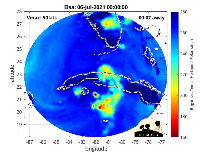
wxman57 wrote:Exposed center appears to be near 24.9N/83W. Getting more separation from the squall to the east.
Is the exposed center a result of shear?...or possibly a center reformation?..good morning btw!
1 likes
-
AlphaToOmega
- Category 5
- Posts: 1448
- Joined: Sat Jun 26, 2021 10:51 am
- Location: Somewhere in Massachusetts
Re: ATL: ELSA - Tropical Storm - Discussion
As we learned, just a few days ago, this system somehow intensifies in unfavorable conditions and weakens in favorable conditions. I would not be surprised if it somehow intensified into a hurricane under 30-knot wind shear.
6 likes

Re: ATL: ELSA - Tropical Storm - Discussion
wxman57 wrote:eastcoastFL wrote:wxman57 wrote:
They are right about in the radius of max winds. Unfortunately, they nor we can separate the TS winds from the center in our graphics. There is probably a small band of TS wind east of the center in that heavy squall area. Looks like max winds are about 40 kts, though one could argue that they could be as high as 45 kts somewhere in that squall.
The only sustained winds I’ve seen so far over 40kts is sand key. They’ve been reporting for over an hour now sustained 40+kt winds
What is Sand Key's ICAO? (the 3-letter station identifier)
Here's a good link to Sand Key C-MAN station.
https://www.wrh.noaa.gov/mesowest/times ... aw=0&w=325
0 likes
-
InfernoFlameCat
- Category 5
- Posts: 2127
- Age: 22
- Joined: Mon Dec 14, 2020 10:52 am
- Location: Buford, GA
Re: ATL: ELSA - Tropical Storm - Discussion
I think Paulette intensified in 50 knot shear into a hurricane so for sure not impossible
2 likes
I am by no means a professional. DO NOT look at my forecasts for official information or make decisions based on what I post.
Goal: to become a registered expert over tropical and subtropical cyclones.
Goal: to become a registered expert over tropical and subtropical cyclones.
-
AlphaToOmega
- Category 5
- Posts: 1448
- Joined: Sat Jun 26, 2021 10:51 am
- Location: Somewhere in Massachusetts
Re: ATL: ELSA - Tropical Storm - Discussion
Parts of Florida could see ~1.5 meters (5 feet) of storm surge.
1 likes
-
wxman57
- Moderator-Pro Met
- Posts: 23175
- Age: 68
- Joined: Sat Jun 21, 2003 8:06 pm
- Location: Houston, TX (southwest)
Re: ATL: ELSA - Tropical Storm - Discussion
NHC still forecasting strengthening today, probably because the Euro was indicating strengthening. Clearly, they don't want the public to lower their guard in case it does strengthen. I have 40-45 kts in my forecast and no strengthening. My forecasts aren't seen by the public, though.
7 likes
-
wxman57
- Moderator-Pro Met
- Posts: 23175
- Age: 68
- Joined: Sat Jun 21, 2003 8:06 pm
- Location: Houston, TX (southwest)
Re: ATL: ELSA - Tropical Storm - Discussion
AlphaToOmega wrote:Parts of Florida could see ~1.5 meters (5 feet) of storm surge.
That would be the extreme. 2-3 ft more likely with onshore flow up to 30-40 kts.
1 likes
-
InfernoFlameCat
- Category 5
- Posts: 2127
- Age: 22
- Joined: Mon Dec 14, 2020 10:52 am
- Location: Buford, GA
Re: ATL: ELSA - Tropical Storm - Discussion
She is definitely intensifying on radar. Through upper/mid level wind intake, is there a name for that? I think it is called Divergence but I am not sure. Earlier I was trying to think of the word in my posts but could not remember.
Last edited by InfernoFlameCat on Tue Jul 06, 2021 9:51 am, edited 1 time in total.
3 likes
I am by no means a professional. DO NOT look at my forecasts for official information or make decisions based on what I post.
Goal: to become a registered expert over tropical and subtropical cyclones.
Goal: to become a registered expert over tropical and subtropical cyclones.
-
Evil Jeremy

- S2K Supporter

- Posts: 5463
- Age: 32
- Joined: Mon Apr 10, 2006 2:10 pm
- Location: Los Angeles, CA
Re: ATL: ELSA - Tropical Storm - Discussion
So the new advisory has Elsa strengthening back from a TD to a TS while still inland (over NC/VA)
Is there precedent for that in that region? This isn’t a Florida/Everglades dynamic.
Is there precedent for that in that region? This isn’t a Florida/Everglades dynamic.
Last edited by Evil Jeremy on Tue Jul 06, 2021 9:51 am, edited 2 times in total.
0 likes
Frances 04 / Jeanne 04 / Katrina 05 / Wilma 05 / Fay 08 / Debby 12 / Andrea 13 / Colin 16 / Hermine 16 / Matthew 16 / Irma 17


Re: ATL: ELSA - Tropical Storm - Discussion
wxman57 wrote:AlphaToOmega wrote:Parts of Florida could see ~1.5 meters (5 feet) of storm surge.
That would be the extreme. 2-3 ft more likely with onshore flow up to 30-40 kts.
If we do get a strong onshore wind into Tampa Bay, 3 to 5 foot surge is very possible. It is very shallow and it doesn't take much to pile it up.
There are a lot of clips on YouTube from TS Eta last year around here, and it was over 50 miles away.
[youtube]https://youtu.be/4xH2LqptCwQ[/youtube]
3 likes

Re: ATL: ELSA - Tropical Storm - Discussion
SE FL is bone dry and I don't see any bands coming this way on the radar. We might get less rain here than we do on a normal summer day. Very light winds as well (10-15 mph).
0 likes
Re: ATL: ELSA - Tropical Storm - Discussion
These videos are the coolest things!
It's especially interesting how the "blob" following along behind just keeps lagging...
Gives the storm a "comma" look, rather than what I call a "buzz-saw."
Interestingly, we've seen that "comma" look before in the previous year.
1 likes
Cleo - 1964, Betsy - 1965, David - 1979, Andrew - 1992, Charlie (Francis, Ivan, Jeanne) - 2004, Irma - 2017, Ian - 2022, Milton - 2024
-
Hypercane_Kyle

- Category 5
- Posts: 3465
- Joined: Sat Mar 07, 2015 7:58 pm
- Location: Cape Canaveral, FL
Re: ATL: ELSA - Tropical Storm - Discussion
Evil Jeremy wrote:So the new advisory has Elsa strengthening back from a TD to a TS while still inland (over NC/VA)
Is there precedent for that in that region? This isn’t a Florida/Everglades dynamic.
Yes, Claudette did exactly this a few days ago.
4 likes
My posts are my own personal opinion, defer to the National Hurricane Center (NHC) and other NOAA products for decision making during hurricane season.
Re: ATL: ELSA - Tropical Storm - Discussion
Red dot is where the NHC 11 AM Advisory estimated the COC to be.

3 likes
-
InfernoFlameCat
- Category 5
- Posts: 2127
- Age: 22
- Joined: Mon Dec 14, 2020 10:52 am
- Location: Buford, GA
Re: ATL: ELSA - Tropical Storm - Discussion
Its common for sheared storms to look like that. Also when a storm begins extropical transition they tend to shape up like that due to baroclinic forcing.Michele B wrote:
These videos are the coolest things!
It's especially interesting how the "blob" following along behind just keeps lagging...
Gives the storm a "comma" look, rather than what I call a "buzz-saw."
Interestingly, we've seen that "comma" look before in the previous year.
1 likes
I am by no means a professional. DO NOT look at my forecasts for official information or make decisions based on what I post.
Goal: to become a registered expert over tropical and subtropical cyclones.
Goal: to become a registered expert over tropical and subtropical cyclones.
Who is online
Users browsing this forum: No registered users and 69 guests