2021 Indicators: SST's / SAL / MSLP / Shear / Steering / Instability / Sat Images
Moderator: S2k Moderators
Forum rules

The posts in this forum are NOT official forecasts and should not be used as such. They are just the opinion of the poster and may or may not be backed by sound meteorological data. They are NOT endorsed by any professional institution or STORM2K. For official information, please refer to products from the National Hurricane Center and National Weather Service.
-
hurricane2025
- Category 1

- Posts: 254
- Joined: Thu Apr 08, 2021 10:36 am
Re: 2021 Indicators: SST's / SAL / MSLP / Shear / Steering / Instability / Sat Images
When was the last time upper Texas coast/SW LA. had a wet pattern in June and July like this?
0 likes
-
AlphaToOmega
- Category 5

- Posts: 1448
- Joined: Sat Jun 26, 2021 10:51 am
- Location: Somewhere in Massachusetts
Re: 2021 Indicators: SST's / SAL / MSLP / Shear / Steering / Instability / Sat Images
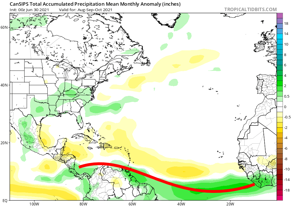
SFLcane wrote:AlphaToOmega wrote:Here is where the ITCZ is likely to be come peak season. Obviously, it is and will be much farther south this year than it was last year.
https://i.postimg.cc/BQ0Q2pYy/itcz.png
Id advise not to use precipitation from climate models to determine potential tropical cyclone tracks. I would take those forecast with caution this season as some of these models are having trouble with Atlantic El Niño and have dry bias. I for one think it probably won’t be a very high number season but more of an impactful year in terms of impacts. I will be ready in SFL as the signs are ominous from looking z500 model output. Just because an area is shaded brown doesn’t mean a tc won’t track through through there.
I have seen how badly precipitation forecasts are when it comes to cyclone tracks, but the ITCZ is not a cyclone track.
2 likes
-
Category5Kaiju

- Category 5
- Posts: 4334
- Joined: Thu Dec 24, 2020 12:45 pm
- Location: Seattle and Phoenix
Re: 2021 Indicators: SST's / SAL / MSLP / Shear / Steering / Instability / Sat Images
Hmmm...
3 likes
Unless explicitly stated, all info in my posts is based on my own opinions and observations. Tropical storms and hurricanes can be extremely dangerous. Refer to an accredited weather research agency or meteorologist if you need to make serious decisions regarding an approaching storm.
-
cycloneye

- Admin

- Posts: 149505
- Age: 69
- Joined: Thu Oct 10, 2002 10:54 am
- Location: San Juan, Puerto Rico
Re: 2021 Indicators: SST's / SAL / MSLP / Shear / Steering / Instability / Sat Images
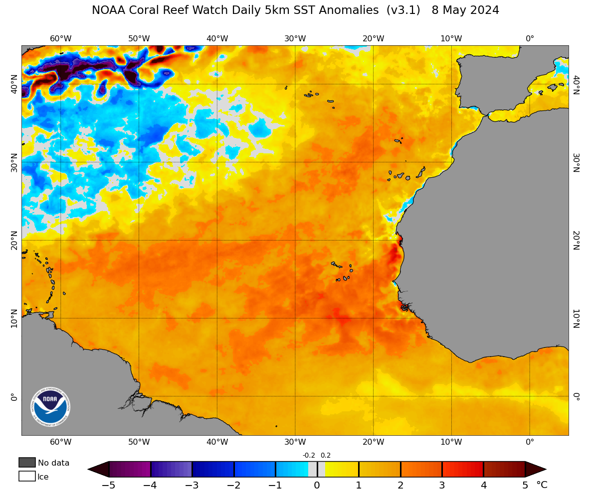
I like better the OISSTv2.

6 likes
Visit the Caribbean-Central America Weather Thread where you can find at first post web cams,radars
and observations from Caribbean basin members Click Here
and observations from Caribbean basin members Click Here
-
toad strangler

- S2K Supporter

- Posts: 4546
- Joined: Sun Jul 28, 2013 3:09 pm
- Location: Earth
- Contact:
Re: 2021 Indicators: SST's / SAL / MSLP / Shear / Steering / Instability / Sat Images
AlphaToOmega wrote:SFLcane wrote:AlphaToOmega wrote:Here is where the ITCZ is likely to be come peak season. Obviously, it is and will be much farther south this year than it was last year.
https://i.postimg.cc/BQ0Q2pYy/itcz.png
Id advise not to use precipitation from climate models to determine potential tropical cyclone tracks. I would take those forecast with caution this season as some of these models are having trouble with Atlantic El Niño and have dry bias. I for one think it probably won’t be a very high number season but more of an impactful year in terms of impacts. I will be ready in SFL as the signs are ominous from looking z500 model output. Just because an area is shaded brown doesn’t mean a tc won’t track through through there.
I have seen how badly precipitation forecasts are when it comes to cyclone tracks, but the ITCZ is not a cyclone track.
Ya, any TC worth it's salt needs to leave the ITCZ umbilical cord. A ITCZ that low (should it verify) combined with recent 500mb long range maps for ASO should have everyone's attention in the SW and overall W part of the basin.
2 likes
My Weather Station
https://www.wunderground.com/dashboard/pws/KFLPORTS603
https://www.wunderground.com/dashboard/pws/KFLPORTS603
-
SFLcane

- S2K Supporter
- Posts: 10281
- Age: 48
- Joined: Sat Jun 05, 2010 1:44 pm
- Location: Lake Worth Florida
Re: 2021 Indicators: SST's / SAL / MSLP / Shear / Steering / Instability / Sat Images
Just give it a few weeks for sleeping giant to wake up.
5 likes
-
AlphaToOmega
- Category 5
- Posts: 1448
- Joined: Sat Jun 26, 2021 10:51 am
- Location: Somewhere in Massachusetts
Re: 2021 Indicators: SST's / SAL / MSLP / Shear / Steering / Instability / Sat Images
I have a strangle feeling that there might be post-season activity is this year. Is it the MJO? Is it the fact that it has been 8 years since the last post-season storm?
0 likes
-
Category5Kaiju
- Category 5
- Posts: 4334
- Joined: Thu Dec 24, 2020 12:45 pm
- Location: Seattle and Phoenix
Re: 2021 Indicators: SST's / SAL / MSLP / Shear / Steering / Instability / Sat Images
Ok so it's somewhat visible on that map too; I think the warmth near the equator is creeping a bit northward (either that or the MDR itself is warming up a bit). The MDR does not seem to be *that* anomalously cool as it was before.
1 likes
Unless explicitly stated, all info in my posts is based on my own opinions and observations. Tropical storms and hurricanes can be extremely dangerous. Refer to an accredited weather research agency or meteorologist if you need to make serious decisions regarding an approaching storm.

Re: 2021 Indicators: SST's / SAL / MSLP / Shear / Steering / Instability / Sat Images
hurricane2025 wrote:When was the last time upper Texas coast/SW LA. had a wet pattern in June and July like this?
Not 100% sure that far west. I did see a video from Ch 4 NOLA the other day that they are already over 60”. If they get just average rainfall the rest of the year it would be 3rd all time. It was a weird and disparate set of years that were in the Top 6 - 1991, 1983, 1961, 1992, 2009, 2004. Nothing notable there in N.O. but Andrew hit near Morgan City in 1992. ‘04 was ‘04. I thought the tv report referenced 1995 as well but that might have only been to this far into the year.
1 likes
-
AnnularCane

- S2K Supporter
- Posts: 2962
- Joined: Thu Jun 08, 2006 9:18 am
- Location: Wytheville, VA
Re: 2021 Indicators: SST's / SAL / MSLP / Shear / Steering / Instability / Sat Images
1 likes
"But it never rained rain. It never snowed snow. And it never blew just wind. It rained things like soup and juice. It snowed mashed potatoes and green peas. And sometimes the wind blew in storms of hamburgers." -- Judi Barrett, Cloudy with a Chance of Meatballs
Re: 2021 Indicators: SST's / SAL / MSLP / Shear / Steering / Instability / Sat Images
AnnularCane wrote::uarrow: Oddly, outside of the white Christmas and the tropics, I seem to remember very little about the weather in 2004. Even local (NOLA at the time) weather, so don't remember it being overly wet. Weird.
Yeah. That was the first Xmas it snowed since the 1950’s. Other events were Ivan part I (windy) and II (more rain). And then Matthew hit Cocodrie the second week of October. We got 6-8” that night too. That was back when we only had 10-15 systems a year. Haha
1 likes
-
AlphaToOmega
- Category 5
- Posts: 1448
- Joined: Sat Jun 26, 2021 10:51 am
- Location: Somewhere in Massachusetts
Re: 2021 Indicators: SST's / SAL / MSLP / Shear / Steering / Instability / Sat Images
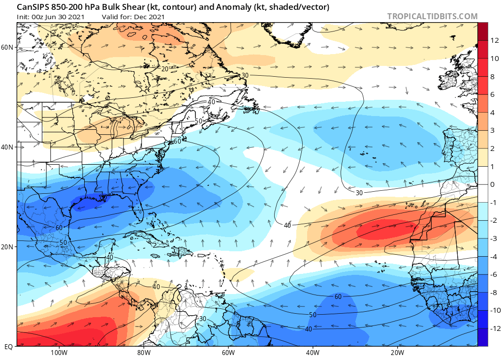
This seems like a favorable mid-latitude pattern for December. The season might not be over by November 30.
0 likes
-
Stormybajan

- Category 1
- Posts: 453
- Joined: Thu May 20, 2021 3:21 pm
- Location: Windward Islands
Re: 2021 Indicators: SST's / SAL / MSLP / Shear / Steering / Instability / Sat Images
Stormybajan wrote:toad strangler wrote:No deviation in anticipated schedule as of yet
http://twitter.com/AndyHazelton/status/1416129137698299904?s=20
Based on this, looks like we may have to wait until August 7th for activity to get going again. Elsa formed July 1st so this will be a massive break..even longer than I first thought
https://twitter.com/AndyHazelton/status/1417084693233741824
2 likes
Sad West Indies and Manchester United fan ⚽️
-
tolakram
- Admin
- Posts: 20186
- Age: 62
- Joined: Sun Aug 27, 2006 8:23 pm
- Location: Florence, KY (name is Mark)
Re: 2021 Indicators: SST's / SAL / MSLP / Shear / Steering / Instability / Sat Images
Second wettest summer in Cincinnati on record. Hurricane seasons for our wettest years are all over the place.

Of the top 5 two had significant hurricanes into Florida. Other than that there doesn't seem to be any correlation with fast or slow seasons.
Of the top 5 two had significant hurricanes into Florida. Other than that there doesn't seem to be any correlation with fast or slow seasons.
0 likes
M a r k
- - - - -
Join us in chat: Storm2K Chatroom Invite. Android and IOS apps also available.
The posts in this forum are NOT official forecasts and should not be used as such. Posts are NOT endorsed by any professional institution or STORM2K.org. For official information and forecasts, please refer to NHC and NWS products.
-
NotSparta

- Professional-Met

- Posts: 1677
- Age: 24
- Joined: Fri Aug 18, 2017 8:24 am
- Location: Naples, FL
- Contact:
Re: 2021 Indicators: SST's / SAL / MSLP / Shear / Steering / Instability / Sat Images
AlphaToOmega wrote:This seems like a favorable mid-latitude pattern for December. The season might not be over by November 30.
https://i.postimg.cc/527Qp43Y/cansips-ashear-atl-6.png
Shear looks high everywhere but yeah perhaps we could see some sort of high-latitude system. Those are always hard to predict though
0 likes
This post was probably an opinion of mine, and in no way is official. Please refer to http://www.hurricanes.gov for official tropical analysis and advisories.
My website, with lots of tropical wx graphics, including satellite and recon: http://cyclonicwx.com
My website, with lots of tropical wx graphics, including satellite and recon: http://cyclonicwx.com
-
toad strangler
- S2K Supporter
- Posts: 4546
- Joined: Sun Jul 28, 2013 3:09 pm
- Location: Earth
- Contact:
Re: 2021 Indicators: SST's / SAL / MSLP / Shear / Steering / Instability / Sat Images
I'm not a believer in preceding seasonal precipitation records wet or dry having anything to do with heightened landfall risks come hurricane season.
1 likes
My Weather Station
https://www.wunderground.com/dashboard/pws/KFLPORTS603
https://www.wunderground.com/dashboard/pws/KFLPORTS603
-
Category5Kaiju
- Category 5
- Posts: 4334
- Joined: Thu Dec 24, 2020 12:45 pm
- Location: Seattle and Phoenix
Re: 2021 Indicators: SST's / SAL / MSLP / Shear / Steering / Instability / Sat Images
tolakram wrote:Second wettest summer in Cincinnati on record. Hurricane seasons for our wettest years are all over the place.
https://i.imgur.com/LhMRmqX.png
Of the top 5 two had significant hurricanes into Florida. Other than that there doesn't seem to be any correlation with fast or slow seasons.
Haha, 2013's in there...but then you look at 1928, 1932, and 1998, and oh snap.
0 likes
Unless explicitly stated, all info in my posts is based on my own opinions and observations. Tropical storms and hurricanes can be extremely dangerous. Refer to an accredited weather research agency or meteorologist if you need to make serious decisions regarding an approaching storm.
-
SconnieCane
- Category 5
- Posts: 1013
- Joined: Thu Aug 02, 2018 5:29 pm
- Location: Madison, WI
Re: 2021 Indicators: SST's / SAL / MSLP / Shear / Steering / Instability / Sat Images
Category5Kaiju wrote:tolakram wrote:Second wettest summer in Cincinnati on record. Hurricane seasons for our wettest years are all over the place.
https://i.imgur.com/LhMRmqX.png
Of the top 5 two had significant hurricanes into Florida. Other than that there doesn't seem to be any correlation with fast or slow seasons.
Haha, 2013's in there...but then you look at 1928, 1932, and 1998, and oh snap.
I think 2013 can pretty much be thrown out as an Atlantic hurricane season analog whenever it pops up, since the thing that caused it to fail was not really part of the usual suite of seasonal "predictors," correct?
2 likes
Who is online
Users browsing this forum: MarioProtVI and 268 guests