2021 Indicators: SST's / SAL / MSLP / Shear / Steering / Instability / Sat Images

This is the general tropical discussion area. Anyone can take their shot at predicting a storms path.

Moderator: S2k Moderators

Forum rules

The posts in this forum are NOT official forecasts and should not be used as such. They are just the opinion of the poster and may or may not be backed by sound meteorological data. They are NOT endorsed by any professional institution or STORM2K. For official information, please refer to products from the National Hurricane Center and National Weather Service.

Help Support Storm2K
Message
Author
AlphaToOmega
Category 5
Category 5
Posts: 1448
Joined: Sat Jun 26, 2021 10:51 am
Location: Somewhere in Massachusetts

Re: 2021 Indicators: SST's / SAL / MSLP / Shear / Steering / Instability / Sat Images

#2041 Postby AlphaToOmega » Sat Jul 31, 2021 6:32 pm

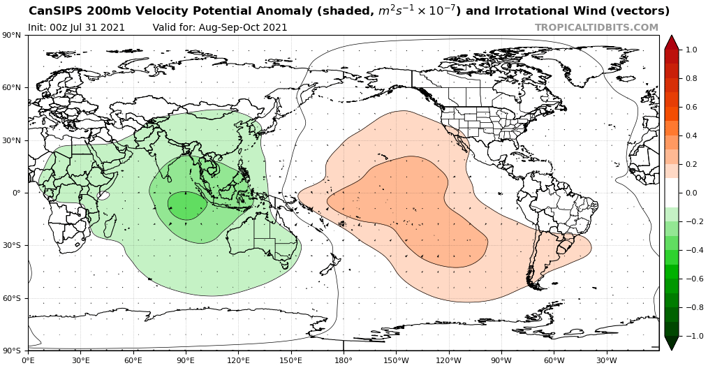
Kingarabian wrote:Even though the MJO signal per RMM was very weak in 2017, it was at least not in the Atlantic inactive phase for the month of August and most of September. That in itself means the MJO is actually playing a role in enhanced TC activity. This will also be true in about 2 weeks from now. In terms of Climo, the MJO is very weak during the summer months and even through September, compared to late fall and early winter. it takes very little MJO amplitude (which is easier to see on hovmollers than RMM during these months) to trigger TCG.

The current MJO event over the Pacific is actually much stronger than normal considering the time of year, and if it ends up in the Atlantic, we should expect a big uptick in activity similar to what we're currently seeing in the EPAC.


This is why I am very bullish for August. The high amplitude of the MJO was shown in June and July: four tropical storms formed in a 20-day period, and then nothing formed. I expect a very active, impactful August.
0 likes   

User avatar
Woofde
Category 1
Category 1
Posts: 480
Joined: Tue Jul 06, 2021 11:33 am

Re: 2021 Indicators: SST's / SAL / MSLP / Shear / Steering / Instability / Sat Images

#2042 Postby Woofde » Sat Jul 31, 2021 6:43 pm

SSTs definitely have warmed up a lot as of recently. The flip side to a calm period is that there are few storms to upwell and use the heat content of the ocean.

It will be interesting to see if this trend continues or if it stops or reverses as we enter a more active period.Image

Sent from my SM-G988U1 using Tapatalk
7 likes   

AlphaToOmega
Category 5
Category 5
Posts: 1448
Joined: Sat Jun 26, 2021 10:51 am
Location: Somewhere in Massachusetts

Re: 2021 Indicators: SST's / SAL / MSLP / Shear / Steering / Instability / Sat Images

#2043 Postby AlphaToOmega » Sat Jul 31, 2021 7:36 pm

The CanSIPS still shows a VP anomaly pattern similar to 2010 and 2020. There is no -VP EPac cell.
Image
6 likes   

User avatar
aspen
Category 5
Category 5
Posts: 8818
Joined: Sat Oct 12, 2019 7:10 pm
Location: Connecticut, USA

Re: 2021 Indicators: SST's / SAL / MSLP / Shear / Steering / Instability / Sat Images

#2044 Postby aspen » Sat Jul 31, 2021 8:36 pm

This phase of EPac activity might give us a hint as to what will happen with the Atlantic starting in a few weeks. While many of these storms are struggling/will struggle due to -ENSO conditions and how close to they are to each other, one thing is clear: the passing MJO has caused a significant spike in TCG in the basin. If the EPac can produce multiple systems like this despite a less favorable base state than the Atlantic, then we could see an activity spike of a similar degree once the MJO has moved basins.

I think it’s possible we could see western development during the early parts of the MJO passage in the August 5-10th range (as tolkram has suggested). Perhaps one of the waves currently in the eastern Atlantic will have lucky timing and arrive in the western part of the basin just as it becomes favorable for genesis and intensification. The CFS hasn’t shown anything like that, but it has proven it cannot catch every single storm, only some of the big ones it seems. Odds are a few slip through the cracks this season too.
5 likes   
Irene '11 Sandy '12 Hermine '16 5/15/2018 Derecho Fay '20 Isaias '20 Elsa '21 Henri '21 Ida '21

I am only a meteorology enthusiast who knows a decent amount about tropical cyclones. Look to the professional mets, the NHC, or your local weather office for the best information.

User avatar
cycloneye
Admin
Admin
Posts: 145327
Age: 68
Joined: Thu Oct 10, 2002 10:54 am
Location: San Juan, Puerto Rico

Re: 2021 Indicators: SST's / SAL / MSLP / Shear / Steering / Instability / Sat Images

#2045 Postby cycloneye » Sat Jul 31, 2021 9:29 pm

0 likes   
Visit the Caribbean-Central America Weather Thread where you can find at first post web cams,radars
and observations from Caribbean basin members Click Here

User avatar
gatorcane
S2K Supporter
S2K Supporter
Posts: 23691
Age: 47
Joined: Sun Mar 13, 2005 3:54 pm
Location: Boca Raton, FL

Re: 2021 Indicators: SST's / SAL / MSLP / Shear / Steering / Instability / Sat Images

#2046 Postby gatorcane » Sat Jul 31, 2021 9:30 pm

A really dry and stable airmass across most of the Atlantic tonight. Here in South Florida, we are experiencing some of this airmass with few clouds and sunny, hot, desert-like conditions. Is very typical for this time of year. Usually by mid August, dry air begins to lose its grip, upper-level winds diminish and the flip switches:

Image
8 likes   

Shell Mound
Category 5
Category 5
Posts: 2434
Age: 32
Joined: Thu Sep 07, 2017 3:39 pm
Location: St. Petersburg, FL → Scandinavia

Re: 2021 Indicators: SST's / SAL / MSLP / Shear / Steering / Instability / Sat Images

#2047 Postby Shell Mound » Sun Aug 01, 2021 2:46 am

0 likes   
CVW / MiamiensisWx / Shell Mound
The posts in this forum are NOT official forecasts and should not be used as such. They are just the opinion of the poster and may or may not be backed by sound meteorological data. They are NOT endorsed by any professional institution or STORM2K. For official information, please refer to products from the NHC and NWS.

Shell Mound
Category 5
Category 5
Posts: 2434
Age: 32
Joined: Thu Sep 07, 2017 3:39 pm
Location: St. Petersburg, FL → Scandinavia

Re: 2021 Indicators: SST's / SAL / MSLP / Shear / Steering / Instability / Sat Images

#2048 Postby Shell Mound » Sun Aug 01, 2021 5:01 am

Kingarabian wrote:The current MJO event over the Pacific is actually much stronger than normal considering the time of year, and if it ends up in the Atlantic, we should expect a big uptick in activity similar to what we're currently seeing in the EPAC.

The EPAC systems are actually performing better than one might expect, considering their proximity to one another during -PMM/-PDO/-ENSO. Perhaps this suggests that the background state is more conducive to TCG in the Pacific than the Atlantic in 2021. Until the MJO shifts into the Atlantic systems will struggle due to sinking air and a strong TUTT. I do think we could see some attempts at brief TCG near West Africa during the second week of August, but anything that forms will dissipate rather quickly as it encounters hostile conditions near the islands. Also, the aforementioned TUTT will tend to undercut the WAR and allow avenues for a stronger system to head northward and miss the CONUS.
0 likes   
CVW / MiamiensisWx / Shell Mound
The posts in this forum are NOT official forecasts and should not be used as such. They are just the opinion of the poster and may or may not be backed by sound meteorological data. They are NOT endorsed by any professional institution or STORM2K. For official information, please refer to products from the NHC and NWS.

AlphaToOmega
Category 5
Category 5
Posts: 1448
Joined: Sat Jun 26, 2021 10:51 am
Location: Somewhere in Massachusetts

Re: 2021 Indicators: SST's / SAL / MSLP / Shear / Steering / Instability / Sat Images

#2049 Postby AlphaToOmega » Sun Aug 01, 2021 5:46 am

Shell Mound wrote:
Kingarabian wrote:The current MJO event over the Pacific is actually much stronger than normal considering the time of year, and if it ends up in the Atlantic, we should expect a big uptick in activity similar to what we're currently seeing in the EPAC.

The EPAC systems are actually performing better than one might expect, considering their proximity to one another during -PMM/-PDO/-ENSO. Perhaps this suggests that the background state is more conducive to TCG in the Pacific than the Atlantic in 2021. Until the MJO shifts into the Atlantic systems will struggle due to sinking air and a strong TUTT. I do think we could see some attempts at brief TCG near West Africa during the second week of August, but anything that forms will dissipate rather quickly as it encounters hostile conditions near the islands. Also, the aforementioned TUTT will tend to undercut the WAR and allow avenues for a stronger system to head northward and miss the CONUS.


Systems are doing worse than expected in the Pacific. There have been multiple instances in which disturbances were expected to develop (at or above 70% chance of development) in the Pacific but never developed. No such thing has happened in the Atlantic yet.
5 likes   

MarioProtVI
Category 4
Category 4
Posts: 935
Age: 24
Joined: Sun Sep 29, 2019 7:33 pm
Location: New Jersey

Re: 2021 Indicators: SST's / SAL / MSLP / Shear / Steering / Instability / Sat Images

#2050 Postby MarioProtVI » Sun Aug 01, 2021 5:47 am

Shell Mound wrote:
Kingarabian wrote:The current MJO event over the Pacific is actually much stronger than normal considering the time of year, and if it ends up in the Atlantic, we should expect a big uptick in activity similar to what we're currently seeing in the EPAC.

The EPAC systems are actually performing better than one might expect, considering their proximity to one another during -PMM/-PDO/-ENSO. Perhaps this suggests that the background state is more conducive to TCG in the Pacific than the Atlantic in 2021. Until the MJO shifts into the Atlantic systems will struggle due to sinking air and a strong TUTT. I do think we could see some attempts at brief TCG near West Africa during the second week of August, but anything that forms will dissipate rather quickly as it encounters hostile conditions near the islands. Also, the aforementioned TUTT will tend to undercut the WAR and allow avenues for a stronger system to head northward and miss the CONUS.

Actually the EPac is struggling considering Hilda stopped intensifying and 09E literally fell flat on its head. That shows the EPac is less favorable then thought IMO, and makes me believe Felicia found more of a sweet spot. Also the latest GFS run has a strong TS in the MDR within the next ten days so that point about storms getting sheared near the coast seems moot.
7 likes   

AlphaToOmega
Category 5
Category 5
Posts: 1448
Joined: Sat Jun 26, 2021 10:51 am
Location: Somewhere in Massachusetts

Re: 2021 Indicators: SST's / SAL / MSLP / Shear / Steering / Instability / Sat Images

#2051 Postby AlphaToOmega » Sun Aug 01, 2021 5:47 am

What is happening with the CanSIPS? Why is the MDR near-average? Is this a new climatology?
Image
1 likes   

Shell Mound
Category 5
Category 5
Posts: 2434
Age: 32
Joined: Thu Sep 07, 2017 3:39 pm
Location: St. Petersburg, FL → Scandinavia

Re: 2021 Indicators: SST's / SAL / MSLP / Shear / Steering / Instability / Sat Images

#2052 Postby Shell Mound » Sun Aug 01, 2021 6:01 am

From the Florida weather thread:

gatorcane wrote:
Patrick99 wrote:Is it just me, or has this been one of the "cooler" SFL summers recently? Obviously it's still hot, but it seems to me that we've seen more breezy and overall cloudy periods than usual.

We haven't seen many of those days with light westerly flow when the temp gets to 95+ in Miami/FLL/WPB before the east coast seabreeze kicks in later PM and all hell breaks loose.

Yes overall this summer has not been one of the hottest summers I can remember. That said the last few weeks have been rather hot but really early morning and late evening haven’t been too bad.

Clearly the Bermuda High has been quite dominant since May and has kept most of the summertime convection inland or along the west coast of the peninsula:

Image

Note that cutoff low along the northwestern Gulf Coast and south-southeasterly flow over most of FL. One can almost envision another Irma- or Elsa-type track:

Image

Overall view of the mid-level (500-mb) regime during the aforementioned timeframe (note the pronounced ridging over and just south of Newfoundland):

Image

A comparison with the H5 pattern during the same timeframe in 2017 shows a similar weakness or cutoff low along the northwestern Gulf Coast:

Image

The major difference is that ridging is farther north thus far in 2021 vs. 2017, so there is more of a chance for impacts farther north along the East Coast.

As an aside, I looked for years that featured TS or stronger tracks similar to Elsa’s that passed within 50 n mi of Steinhatchee, FL, and found the following:

Image

The years were 1853, 1885, 1889, 1902, 1924, 1960, 1996, 2000, and 2013. The above image highlights all MH tracks that occurred in those seasons.

Image

This H5 configuration from late August 1880 looks similar to the H5 pattern since early June 2021 and yielded a strong hurricane impact on eastern FL.
Last edited by Shell Mound on Sun Aug 01, 2021 7:53 am, edited 1 time in total.
1 likes   
CVW / MiamiensisWx / Shell Mound
The posts in this forum are NOT official forecasts and should not be used as such. They are just the opinion of the poster and may or may not be backed by sound meteorological data. They are NOT endorsed by any professional institution or STORM2K. For official information, please refer to products from the NHC and NWS.

User avatar
cycloneye
Admin
Admin
Posts: 145327
Age: 68
Joined: Thu Oct 10, 2002 10:54 am
Location: San Juan, Puerto Rico

Re: 2021 Indicators: SST's / SAL / MSLP / Shear / Steering / Instability / Sat Images

#2053 Postby cycloneye » Sun Aug 01, 2021 7:53 am

1 likes   
Visit the Caribbean-Central America Weather Thread where you can find at first post web cams,radars
and observations from Caribbean basin members Click Here

Shell Mound
Category 5
Category 5
Posts: 2434
Age: 32
Joined: Thu Sep 07, 2017 3:39 pm
Location: St. Petersburg, FL → Scandinavia

Re: 2021 Indicators: SST's / SAL / MSLP / Shear / Steering / Instability / Sat Images

#2054 Postby Shell Mound » Sun Aug 01, 2021 8:13 am

0 likes   
CVW / MiamiensisWx / Shell Mound
The posts in this forum are NOT official forecasts and should not be used as such. They are just the opinion of the poster and may or may not be backed by sound meteorological data. They are NOT endorsed by any professional institution or STORM2K. For official information, please refer to products from the NHC and NWS.

AlphaToOmega
Category 5
Category 5
Posts: 1448
Joined: Sat Jun 26, 2021 10:51 am
Location: Somewhere in Massachusetts

Re: 2021 Indicators: SST's / SAL / MSLP / Shear / Steering / Instability / Sat Images

#2055 Postby AlphaToOmega » Sun Aug 01, 2021 8:22 am

Image
0 likes   

User avatar
Category5Kaiju
Category 5
Category 5
Posts: 4097
Joined: Thu Dec 24, 2020 12:45 pm
Location: Seattle

Re: 2021 Indicators: SST's / SAL / MSLP / Shear / Steering / Instability / Sat Images

#2056 Postby Category5Kaiju » Sun Aug 01, 2021 8:46 am

Shell Mound wrote:
Kingarabian wrote:The current MJO event over the Pacific is actually much stronger than normal considering the time of year, and if it ends up in the Atlantic, we should expect a big uptick in activity similar to what we're currently seeing in the EPAC.

The EPAC systems are actually performing better than one might expect, considering their proximity to one another during -PMM/-PDO/-ENSO. Perhaps this suggests that the background state is more conducive to TCG in the Pacific than the Atlantic in 2021. Until the MJO shifts into the Atlantic systems will struggle due to sinking air and a strong TUTT. I do think we could see some attempts at brief TCG near West Africa during the second week of August, but anything that forms will dissipate rather quickly as it encounters hostile conditions near the islands. Also, the aforementioned TUTT will tend to undercut the WAR and allow avenues for a stronger system to head northward and miss the CONUS.


From my understanding the depression on Hilda’s left was supposed to become a NS soon, and now it is forecast to remain as remnants of a depression. Hilda to the right was getting sheared by the systems around it many times recently. So I am not very sure if saying that the EPAC have been performing better than expected would be a suitable description; in fact, recent years in the EPAC since 2014 (even -ENSO years) typically would have already had at least 2 majors in the basin by August 1st, and so far we have only seen 1.
1 likes   
Unless explicitly stated, all info in my posts is based on my own opinions and observations. Tropical storms and hurricanes can be extremely dangerous. Do not think you can beat Mother Nature. Refer to an accredited weather research agency or meteorologist if you need to make serious decisions regarding an approaching storm.

AlphaToOmega
Category 5
Category 5
Posts: 1448
Joined: Sat Jun 26, 2021 10:51 am
Location: Somewhere in Massachusetts

Re: 2021 Indicators: SST's / SAL / MSLP / Shear / Steering / Instability / Sat Images

#2057 Postby AlphaToOmega » Sun Aug 01, 2021 9:19 am

I believe 1995 is a good analog in terms of steering and landfalls: +NAO, SE Canada ridge, Atlantic Niño, and -ENSO.
0 likes   

Shell Mound
Category 5
Category 5
Posts: 2434
Age: 32
Joined: Thu Sep 07, 2017 3:39 pm
Location: St. Petersburg, FL → Scandinavia

Re: 2021 Indicators: SST's / SAL / MSLP / Shear / Steering / Instability / Sat Images

#2058 Postby Shell Mound » Sun Aug 01, 2021 9:22 am

Image
The MJO’s being in 8/1/2 while entering a lower amplitude would support a retrogressive “blocking” pattern emerging by mid August, favouring potential impacts.
1 likes   
CVW / MiamiensisWx / Shell Mound
The posts in this forum are NOT official forecasts and should not be used as such. They are just the opinion of the poster and may or may not be backed by sound meteorological data. They are NOT endorsed by any professional institution or STORM2K. For official information, please refer to products from the NHC and NWS.

User avatar
Category5Kaiju
Category 5
Category 5
Posts: 4097
Joined: Thu Dec 24, 2020 12:45 pm
Location: Seattle

Re: 2021 Indicators: SST's / SAL / MSLP / Shear / Steering / Instability / Sat Images

#2059 Postby Category5Kaiju » Sun Aug 01, 2021 9:23 am

AlphaToOmega wrote:I believe 1995 is a good analog in terms of steering and landfalls: +NAO, SE Canada ridge, Atlantic Niño, and -ENSO.


I personally think a combination between 1996, 1999, 2004, and 2007 would be a good analog too
1 likes   
Unless explicitly stated, all info in my posts is based on my own opinions and observations. Tropical storms and hurricanes can be extremely dangerous. Do not think you can beat Mother Nature. Refer to an accredited weather research agency or meteorologist if you need to make serious decisions regarding an approaching storm.

User avatar
aspen
Category 5
Category 5
Posts: 8818
Joined: Sat Oct 12, 2019 7:10 pm
Location: Connecticut, USA

Re: 2021 Indicators: SST's / SAL / MSLP / Shear / Steering / Instability / Sat Images

#2060 Postby aspen » Sun Aug 01, 2021 9:28 am

AlphaToOmega wrote:I believe 1995 is a good analog in terms of steering and landfalls: +NAO, SE Canada ridge, Atlantic Niño, and -ENSO.

Perhaps the possible future Fred could be analogous to 1995’s Hurricane Felix. It formed in the far eastern MDR on August 8th — around the same time Fred has been modeled to develop — and remained weak for most of its time in the MDR before it really got going between 20-25N. Felix’s track is similar to the 06z GFS track (although that’s likely to change). I can see future Fred taking a while to get going while it’s stuck in the MDR, before finding better luck further NW in mid-August, just like Felix.

I’m not saying it’s gonna become a Cat 4 though.
0 likes   
Irene '11 Sandy '12 Hermine '16 5/15/2018 Derecho Fay '20 Isaias '20 Elsa '21 Henri '21 Ida '21

I am only a meteorology enthusiast who knows a decent amount about tropical cyclones. Look to the professional mets, the NHC, or your local weather office for the best information.


Return to “Talkin' Tropics”

Who is online

Users browsing this forum: NotSparta and 31 guests