2021 EPAC Season
Moderator: S2k Moderators
Forum rules

The posts in this forum are NOT official forecasts and should not be used as such. They are just the opinion of the poster and may or may not be backed by sound meteorological data. They are NOT endorsed by any professional institution or STORM2K. For official information, please refer to products from the National Hurricane Center and National Weather Service.
-
Yellow Evan

- Professional-Met

- Posts: 16240
- Age: 27
- Joined: Fri Jul 15, 2011 12:48 pm
- Location: Henderson, Nevada/Honolulu, HI
- Contact:
-
Yellow Evan
- Professional-Met
- Posts: 16240
- Age: 27
- Joined: Fri Jul 15, 2011 12:48 pm
- Location: Henderson, Nevada/Honolulu, HI
- Contact:
Re: 2021 EPAC Season


0z ECMWF caving to GFS with regards to long range activity as well as the 30/60 getting absorbed by 90E.
0 likes
-
Yellow Evan
- Professional-Met
- Posts: 16240
- Age: 27
- Joined: Fri Jul 15, 2011 12:48 pm
- Location: Henderson, Nevada/Honolulu, HI
- Contact:
Re: 2021 EPAC Season


12z ECMWF brings the 30/60 back and now on board for something in 10 days.
0 likes
-
Kingarabian

- S2K Supporter

- Posts: 16366
- Joined: Sat Aug 08, 2009 3:06 am
- Location: Honolulu, Hawaii
Re: 2021 EPAC Season
18z GFS has 6 named systems (including TD9 and Hilda) by the end of its run.
0 likes
RIP Kobe Bryant
-
cycloneye

- Admin

- Posts: 149508
- Age: 69
- Joined: Thu Oct 10, 2002 10:54 am
- Location: San Juan, Puerto Rico
Re: 2021 EPAC Season
Showers and thunderstorms associated with a tropical wave located a
few hundred miles off the coast of southern Mexico have become a
little better organized since yesterday. Continued gradual
development of this system is expected during the next several
days, and a tropical depression is likely to form early next week
while it moves west-northwestward at 10 to 15 mph.
* Formation chance through 48 hours...medium...40 percent.
* Formation chance through 5 days...high...70 percent.
0 likes
Visit the Caribbean-Central America Weather Thread where you can find at first post web cams,radars
and observations from Caribbean basin members Click Here
and observations from Caribbean basin members Click Here
-
Yellow Evan
- Professional-Met
- Posts: 16240
- Age: 27
- Joined: Fri Jul 15, 2011 12:48 pm
- Location: Henderson, Nevada/Honolulu, HI
- Contact:
Re: 2021 EPAC Season


18z GFS makes a borderline hurricane out of 40/70, and then 3 systems including 2 majors behind it.
0 likes

-
captainbarbossa19

- Professional-Met
- Posts: 1094
- Age: 27
- Joined: Wed Aug 21, 2019 11:09 pm
- Location: Beaumont, TX
Re: 2021 EPAC Season
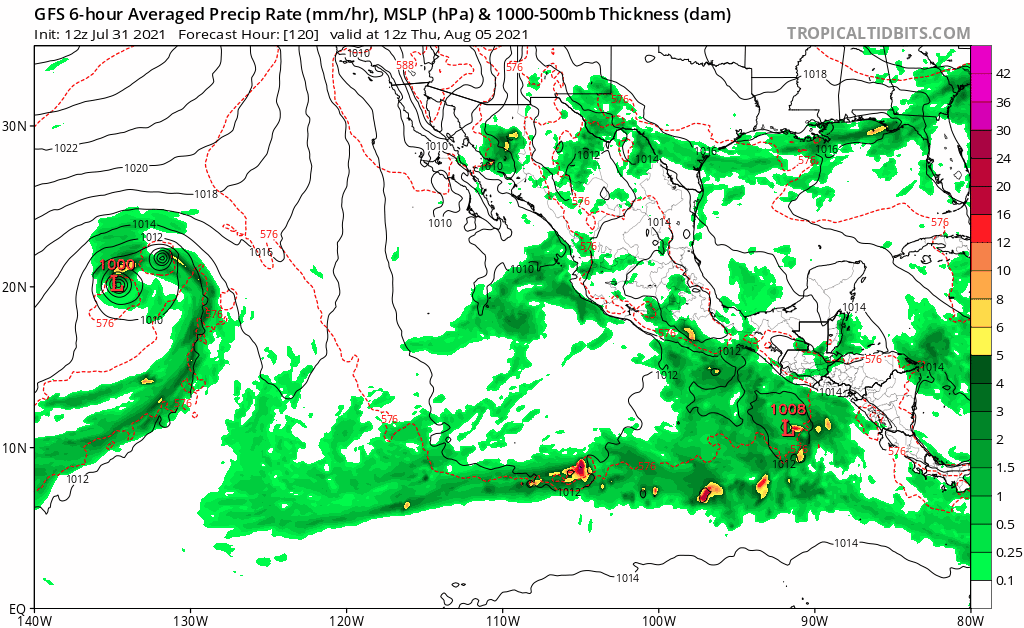
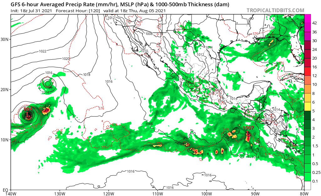
Yellow Evan wrote:https://i.imgur.com/BmN9vNt.png
https://i.imgur.com/bKW4D52.png
https://i.imgur.com/rBCKVTQ.png
18z GFS makes a borderline hurricane out of 40/70, and then 3 systems including 2 majors behind it.
I think the GFS might be too aggressive with these systems. Hilda might become a major though. Also, if the system forms that the GFS shows about a week from now, it could be the last one for a while. I think the Atlantic will probably start to take over at that point (although I will not be surprised if the models do not show this happening).
0 likes
-
cycloneye
- Admin
- Posts: 149508
- Age: 69
- Joined: Thu Oct 10, 2002 10:54 am
- Location: San Juan, Puerto Rico
Re: 2021 EPAC Season
There are 7 systems from start to finish on the 12z GFS run.
0 likes
Visit the Caribbean-Central America Weather Thread where you can find at first post web cams,radars
and observations from Caribbean basin members Click Here
and observations from Caribbean basin members Click Here
-
Yellow Evan
- Professional-Met
- Posts: 16240
- Age: 27
- Joined: Fri Jul 15, 2011 12:48 pm
- Location: Henderson, Nevada/Honolulu, HI
- Contact:
Re: 2021 EPAC Season
captainbarbossa19 wrote:Yellow Evan wrote:https://i.imgur.com/BmN9vNt.png
https://i.imgur.com/bKW4D52.png
https://i.imgur.com/rBCKVTQ.png
18z GFS makes a borderline hurricane out of 40/70, and then 3 systems including 2 majors behind it.
I think the GFS might be too aggressive with these systems. Hilda might become a major though. Also, if the system forms that the GFS shows about a week from now, it could be the last one for a while. I think the Atlantic will probably start to take over at that point (although I will not be surprised if the models do not show this happening).
The GFS is overdoing the -VP setup as I’ve said many times. I’d expect about half as much activity as actually shown.
5 likes
-
Sciencerocks
- Category 5

- Posts: 10186
- Age: 40
- Joined: Thu Jul 06, 2017 1:51 am
-
AlphaToOmega
- Category 5
- Posts: 1448
- Joined: Sat Jun 26, 2021 10:51 am
- Location: Somewhere in Massachusetts

Re: 2021 EPAC Season
The current activity in the EPac is like a multi-car wreck. All three systems are too close to each other, with Hilda dominating over 9E and 91E — systems it might swallow up in a few days. Hilda is also not doing great due to shear. These storms are all too close together for anything but Hilda to be anything of significance over the next few days.
Maybe the system that could form early next week will have better luck, but -ENSO conditions are not kind to EPac systems this year.
Maybe the system that could form early next week will have better luck, but -ENSO conditions are not kind to EPac systems this year.
6 likes
Irene '11 Sandy '12 Hermine '16 5/15/2018 Derecho Fay '20 Isaias '20 Elsa '21 Henri '21 Ida '21
I am only a meteorology enthusiast who knows a decent amount about tropical cyclones. Look to the professional mets, the NHC, or your local weather office for the best information.
I am only a meteorology enthusiast who knows a decent amount about tropical cyclones. Look to the professional mets, the NHC, or your local weather office for the best information.
-
Nancy Smar

- Category 5
- Posts: 1081
- Age: 25
- Joined: Wed Aug 16, 2017 10:03 pm
Re: 2021 EPAC Season
GENESIS015, EP, E, , , , , 76, 2021, DB, O, 2021073112, 9999999999, , 015, , , , GENESIS, , EP762021
0 likes
-
cycloneye
- Admin
- Posts: 149508
- Age: 69
- Joined: Thu Oct 10, 2002 10:54 am
- Location: San Juan, Puerto Rico
Re: 2021 EPAC Season
Nancy Smar wrote:GENESIS015, EP, E, , , , , 76, 2021, DB, O, 2021073112, 9999999999, , 015, , , , GENESIS, , EP762021
92E soon and I envision will be for the powerful hurricane that GFS develops starting on the 5th.
1 likes
Visit the Caribbean-Central America Weather Thread where you can find at first post web cams,radars
and observations from Caribbean basin members Click Here
and observations from Caribbean basin members Click Here
-
Category5Kaiju

- Category 5
- Posts: 4334
- Joined: Thu Dec 24, 2020 12:45 pm
- Location: Seattle and Phoenix
Re: 2021 EPAC Season
So it looks like the TD west of Hilda will not become a storm as projected anymore
0 likes
Unless explicitly stated, all info in my posts is based on my own opinions and observations. Tropical storms and hurricanes can be extremely dangerous. Refer to an accredited weather research agency or meteorologist if you need to make serious decisions regarding an approaching storm.
-
Yellow Evan
- Professional-Met
- Posts: 16240
- Age: 27
- Joined: Fri Jul 15, 2011 12:48 pm
- Location: Henderson, Nevada/Honolulu, HI
- Contact:
Re: 2021 EPAC Season
000
ABPZ30 KNHC 011430
TWSEP
Monthly Tropical Weather Summary
NWS National Hurricane Center Miami FL
800 AM PDT Sun Aug 1 2021
For the eastern North Pacific, east of 140 degrees west longitude:
Four tropical cyclones formed in the month of July in the eastern
Pacific basin. Hurricane Felicia and Tropical Storm Guillermo formed
near the middle of the month, while Hurricane Hilda and Tropical
Depression Nine-E formed near the end of July. None of the cyclones
affected land. Hurricane Felicia rapidly intensified and became a
category 4 hurricane.
The formation of four tropical cyclones, including two hurricanes
and one major hurricane is near the long-term average for July. The
number of named storms (8) in the basin so far in 2021 is above the
long-term average through July (6.3). In terms of Accumulated
Cyclone Energy (ACE), which measures the strength and duration of
tropical storms and hurricanes, the season to date is near the
average of the past 30 years.
Reports on individual cyclones, when completed, are available at
the National Hurricane Center website at:
www.nhc.noaa.gov/data/tcr/index.php?sea ... basin=epac
Summary Table
Name Dates Max Wind (mph)
---------------------------------------------------
TS Andres 9-11 May 40*
TS Blanca 30 May- 4 Jun 60
TS Carlos 12-16 Jun 50
TS Dolores 18-20 Jun 70
H Enrique 25-30 Jun 90
H Felicia 14-20 Jul 145
TS Guillermo 17-20 Jul 60
H Hilda 30 Jul- 85
TD Nine-E 30 Jul- 1 Aug 30
---------------------------------------------------
* Denotes a storm for which the post-storm analysis is complete.
$$
Hurricane Specialist Unit
0 likes
-
Kingarabian
- S2K Supporter
- Posts: 16366
- Joined: Sat Aug 08, 2009 3:06 am
- Location: Honolulu, Hawaii

-
cycloneye
- Admin
- Posts: 149508
- Age: 69
- Joined: Thu Oct 10, 2002 10:54 am
- Location: San Juan, Puerto Rico
Re: 2021 EPAC Season
3 mayors wont verify.
6 likes
Visit the Caribbean-Central America Weather Thread where you can find at first post web cams,radars
and observations from Caribbean basin members Click Here
and observations from Caribbean basin members Click Here
Who is online
Users browsing this forum: No registered users and 194 guests