2021 Indicators: SST's / SAL / MSLP / Shear / Steering / Instability / Sat Images

This is the general tropical discussion area. Anyone can take their shot at predicting a storms path.

Moderator: S2k Moderators

Forum rules

The posts in this forum are NOT official forecasts and should not be used as such. They are just the opinion of the poster and may or may not be backed by sound meteorological data. They are NOT endorsed by any professional institution or STORM2K. For official information, please refer to products from the National Hurricane Center and National Weather Service.

Help Support Storm2K
Message
Author
User avatar
Category5Kaiju
Category 5
Category 5
Posts: 4097
Joined: Thu Dec 24, 2020 12:45 pm
Location: Seattle

Re: 2021 Indicators: SST's / SAL / MSLP / Shear / Steering / Instability / Sat Images

#2241 Postby Category5Kaiju » Thu Aug 05, 2021 12:40 pm

SFLcane wrote:TSR going with 122 ACE seems rather low also reduced there numbers a bit. But they mentioned landfall probability was quite high this season.


Isn't TSR typically one of the most conservative predictors for activity levels?
0 likes   
Unless explicitly stated, all info in my posts is based on my own opinions and observations. Tropical storms and hurricanes can be extremely dangerous. Do not think you can beat Mother Nature. Refer to an accredited weather research agency or meteorologist if you need to make serious decisions regarding an approaching storm.

tolakram
Admin
Admin
Posts: 20009
Age: 62
Joined: Sun Aug 27, 2006 8:23 pm
Location: Florence, KY (name is Mark)

Re: 2021 Indicators: SST's / SAL / MSLP / Shear / Steering / Instability / Sat Images

#2242 Postby tolakram » Thu Aug 05, 2021 1:35 pm

I'm still trying to figure out why Webb thinks it's a good idea to use an adjusted anomaly graph for a predictor. The temperature needed to sustain a tropical cyclone has not changed so moving the shading around is just adding to the confusion. Anyone care to explain what I'm missing?
6 likes   
M a r k
- - - - -
Join us in chat: Storm2K Chatroom Invite. Android and IOS apps also available.

The posts in this forum are NOT official forecasts and should not be used as such. Posts are NOT endorsed by any professional institution or STORM2K.org. For official information and forecasts, please refer to NHC and NWS products.

AlphaToOmega
Category 5
Category 5
Posts: 1448
Joined: Sat Jun 26, 2021 10:51 am
Location: Somewhere in Massachusetts

Re: 2021 Indicators: SST's / SAL / MSLP / Shear / Steering / Instability / Sat Images

#2243 Postby AlphaToOmega » Thu Aug 05, 2021 3:15 pm

Image
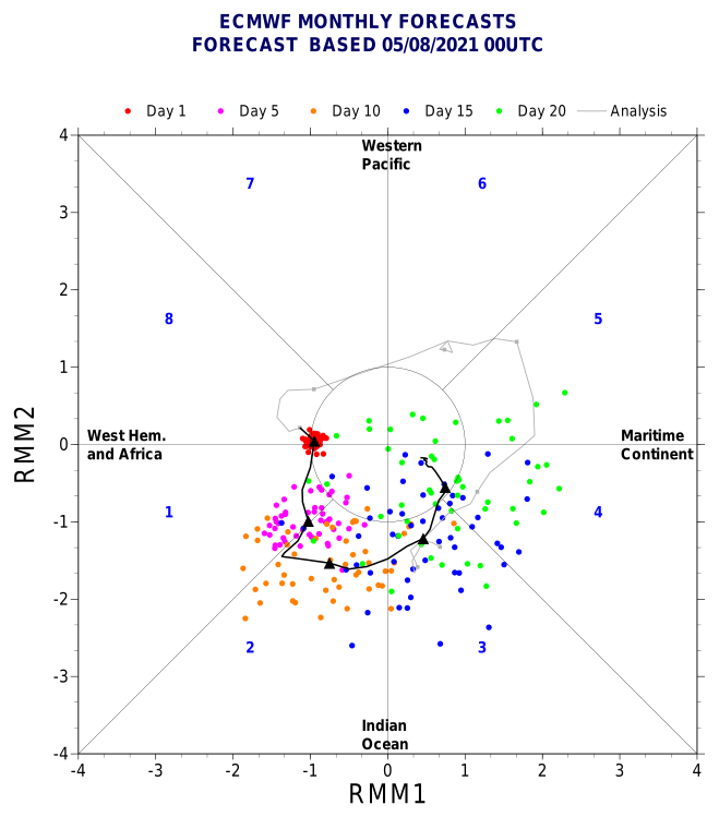
The latest ECMWF MJO forecast shows Phase I by August 6, which should mark the end of the lull period for the Atlantic. Throughout August, the MJO will cycle through Phases II, III, and IV, with Phase IV likely continuing into peak season.
1 likes   

AlphaToOmega
Category 5
Category 5
Posts: 1448
Joined: Sat Jun 26, 2021 10:51 am
Location: Somewhere in Massachusetts

Re: 2021 Indicators: SST's / SAL / MSLP / Shear / Steering / Instability / Sat Images

#2244 Postby AlphaToOmega » Thu Aug 05, 2021 3:18 pm

I have also looked at how IOD relates to hurricane season activity. To my surprise, I could not find a strong correlation. I took the mean of the August, September, and October IOD values to generate an IOD for the peak season. 2020 and 2017 had +IOD during peak season, yet both seasons were hyperactive. 2000 had -IOD during peak season, yet the season was not hyperactive. 2003 was another hyperactive year with +IOD.
0 likes   

hurricane2025
Tropical Storm
Tropical Storm
Posts: 209
Joined: Thu Apr 08, 2021 10:36 am

Re: 2021 Indicators: SST's / SAL / MSLP / Shear / Steering / Instability / Sat Images

#2245 Postby hurricane2025 » Thu Aug 05, 2021 3:23 pm

Big joe all about the gulf I’m newest update
0 likes   

User avatar
captainbarbossa19
Professional-Met
Professional-Met
Posts: 1092
Age: 27
Joined: Wed Aug 21, 2019 11:09 pm
Location: Beaumont, TX

Re: 2021 Indicators: SST's / SAL / MSLP / Shear / Steering / Instability / Sat Images

#2246 Postby captainbarbossa19 » Thu Aug 05, 2021 3:25 pm

AlphaToOmega wrote:https://i.postimg.cc/FzhHzcMt/pdf2svg-worker-commands-5bcd7565f6-7gmw5-6fe5cac1a363ec1525f54343b6cc9fd8-ZFXMm-E.png
The latest ECMWF MJO forecast shows Phase I by August 6, which should mark the end of the lull period for the Atlantic. Throughout August, the MJO will cycle through Phases II, III, and IV, with Phase IV likely continuing into peak season.


August 6 is tomorrow. With 92L emerging off the coast of Africa today, I suspect that the Atlantic is about to take over with activity. It's almost that time folks!
0 likes   

User avatar
Category5Kaiju
Category 5
Category 5
Posts: 4097
Joined: Thu Dec 24, 2020 12:45 pm
Location: Seattle

Re: 2021 Indicators: SST's / SAL / MSLP / Shear / Steering / Instability / Sat Images

#2247 Postby Category5Kaiju » Thu Aug 05, 2021 3:28 pm

captainbarbossa19 wrote:
AlphaToOmega wrote:https://i.postimg.cc/FzhHzcMt/pdf2svg-worker-commands-5bcd7565f6-7gmw5-6fe5cac1a363ec1525f54343b6cc9fd8-ZFXMm-E.png
The latest ECMWF MJO forecast shows Phase I by August 6, which should mark the end of the lull period for the Atlantic. Throughout August, the MJO will cycle through Phases II, III, and IV, with Phase IV likely continuing into peak season.


August 6 is tomorrow. With 92L emerging off the coast of Africa today, I suspect that the Atlantic is about to take over with activity. It's almost that time folks!


Yup, let's just hope Toto doesn't bless the rains too much down there...

But in seriousness though, I would not be surprised if this season is backloaded and we find ourselves tracking storms well into October. I think this developing La Nina will really help the Atlantic in the end.
0 likes   
Unless explicitly stated, all info in my posts is based on my own opinions and observations. Tropical storms and hurricanes can be extremely dangerous. Do not think you can beat Mother Nature. Refer to an accredited weather research agency or meteorologist if you need to make serious decisions regarding an approaching storm.

tolakram
Admin
Admin
Posts: 20009
Age: 62
Joined: Sun Aug 27, 2006 8:23 pm
Location: Florence, KY (name is Mark)

Re: 2021 Indicators: SST's / SAL / MSLP / Shear / Steering / Instability / Sat Images

#2248 Postby tolakram » Thu Aug 05, 2021 3:39 pm

I couple of graphs from CSU's latest forecast.

Image

Image

In these two cases we are very close to hyperactive indicators. Note this is just two indicators they use when making a forecast.
6 likes   
M a r k
- - - - -
Join us in chat: Storm2K Chatroom Invite. Android and IOS apps also available.

The posts in this forum are NOT official forecasts and should not be used as such. Posts are NOT endorsed by any professional institution or STORM2K.org. For official information and forecasts, please refer to NHC and NWS products.

jconsor
Professional-Met
Professional-Met
Posts: 551
Joined: Mon Jun 30, 2008 9:31 pm
Location: Jerusalem, Israel
Contact:

Re: 2021 Indicators: SST's / SAL / MSLP / Shear / Steering / Instability / Sat Images

#2249 Postby jconsor » Thu Aug 05, 2021 3:55 pm

Mark,

I provide some context on Eric Webb's comments here:
 https://twitter.com/yconsor/status/1423377102972276739


To my understanding, the SST anomalies in the tropical Atlantic vs. other *tropical* basins, particularly the eastern/central Pacific and secondarily the Western Indian Ocean, are important in terms of influencing where the main -VP sets up and how unstable the tropical Atlantic ends up being. This of course has a significant impact on tropical cyclone development in the Atlantic.

Here are a few examples to bring out this point. 2019 and 2012 saw slightly above average SSTs in the tropical Atlantic, but these paled in comparison to much warmer than average SSTs in the central/eastern Pacific and western IO. ACE for both years was very close to the 1991-2020 median of 129. In other words, both were basically average in terms of overall tropical activity and below average in terms of MDR activity. 2012 was completely devoid of hurricane activity in the MDR aside from Sandy in October. 2019 had three MDR hurricanes, but both majors (Lorenzo and Dorian) reached peak intensity in the subtropics and the other hurricane (Jerry) was short-lived. Both were "quantity over quality" seasons with many short-lived, weak storms. 2019 had only six of the 18 tropical storms become hurricanes, and three of those hurricanes lasted a day and a half or less. 2012 had only two major hurricanes, with each (Michael and Sandy) only achieving major status for six hours!

On the other hand, 1996 and 1950 saw near to slightly below average SSTs in the tropical Atlantic, but these were warm compared to the colder SSTs in the central/eastern Pacific and western IO. Both were considered extremely active seasons based on the NOAA definition, with ACE of 166 in 1966 and 211 in 1950. Both had numerous MDR hurricanes (six in 1950 and nine in 1996), though in 1950 most of them reached peak intensity in the subtropics. Both were "quality over quantity" seasons with an unusually large % of tropical storms becoming hurricanes and major hurricanes. In 1950 the first seven tropical storms became hurricanes... don't think any other season has done that!

See https://www.cpc.ncep.noaa.gov/products/ ... round.html for 1991-2020 and 1951-2020 median ACE and definitions of "extremely active" seasons.

Note that in each case the SST anomaly maps I have plotted here use a sliding 30 year climatology - for example 1935-1965 for 1950.

Image
Image
Image
Image

tolakram wrote:I'm still trying to figure out why Webb thinks it's a good idea to use an adjusted anomaly graph for a predictor. The temperature needed to sustain a tropical cyclone has not changed so moving the shading around is just adding to the confusion. Anyone care to explain what I'm missing?
13 likes   

AlphaToOmega
Category 5
Category 5
Posts: 1448
Joined: Sat Jun 26, 2021 10:51 am
Location: Somewhere in Massachusetts

Re: 2021 Indicators: SST's / SAL / MSLP / Shear / Steering / Instability / Sat Images

#2250 Postby AlphaToOmega » Thu Aug 05, 2021 4:12 pm

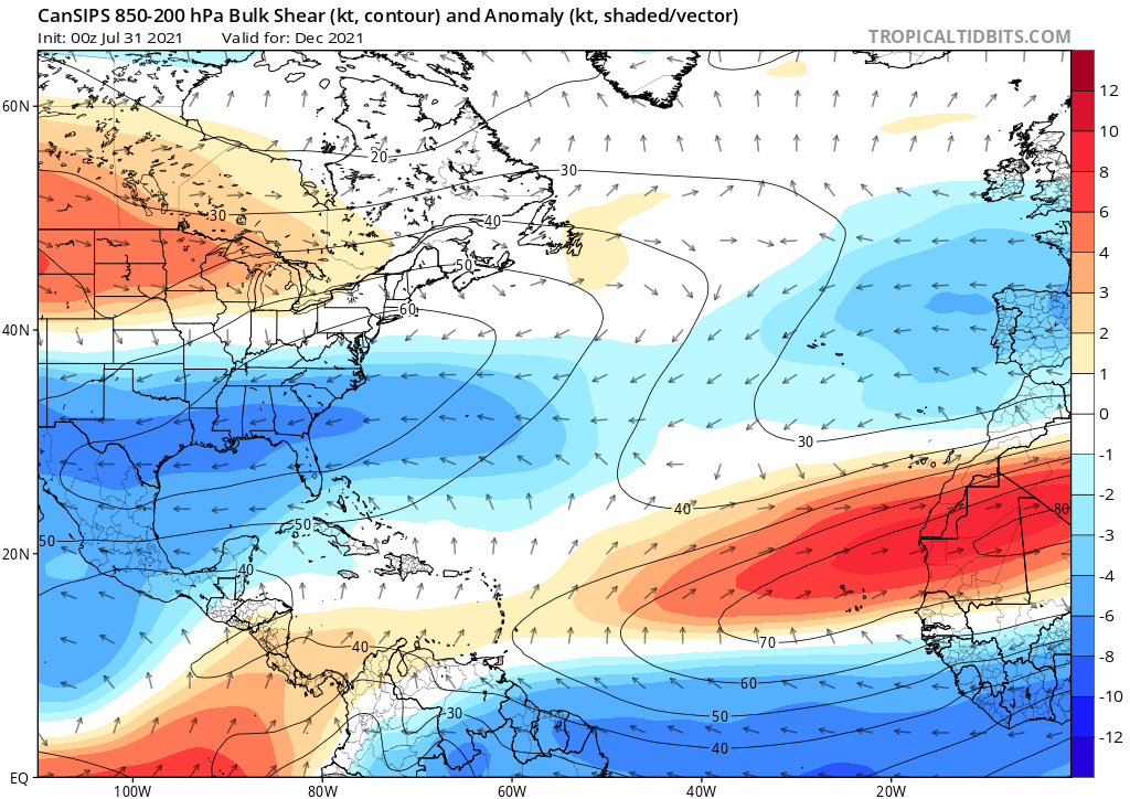
This is a favorable shear pattern for December. Most post-season activity occurs in the subtropics. The most favorable place for development in December is near Iberia. AL201315 as well as Storm Clement, which had the potential to be a tropical cyclone, were in that area. Shear in that area is forecasted to be about 30 knots.
Image
0 likes   

User avatar
toad strangler
S2K Supporter
S2K Supporter
Posts: 4543
Joined: Sun Jul 28, 2013 3:09 pm
Location: Earth
Contact:

Re: 2021 Indicators: SST's / SAL / MSLP / Shear / Steering / Instability / Sat Images

#2251 Postby toad strangler » Thu Aug 05, 2021 4:24 pm

tolakram wrote:I couple of graphs from CSU's latest forecast.

https://i.imgur.com/rJgIEQD.png

https://i.imgur.com/x9Ov9kQ.png

In these two cases we are very close to hyperactive indicators. Note this is just two indicators they use when making a forecast.


Notice in the SST graph that there aren’t any dramatic turns in those arcs so it’s extremely likely the season ends above normal
0 likes   

User avatar
abajan
S2K Supporter
S2K Supporter
Posts: 4231
Joined: Sun Sep 07, 2003 5:10 am
Location: Barbados

Re: 2021 Indicators: SST's / SAL / MSLP / Shear / Steering / Instability / Sat Images

#2252 Postby abajan » Thu Aug 05, 2021 6:48 pm

[youtube]https://youtu.be/53VWPnSFcBM[/youtube]
5 likes   

Shell Mound
Category 5
Category 5
Posts: 2434
Age: 32
Joined: Thu Sep 07, 2017 3:39 pm
Location: St. Petersburg, FL → Scandinavia

Re: 2021 Indicators: SST's / SAL / MSLP / Shear / Steering / Instability / Sat Images

#2253 Postby Shell Mound » Fri Aug 06, 2021 3:17 am

1 likes   
CVW / MiamiensisWx / Shell Mound
The posts in this forum are NOT official forecasts and should not be used as such. They are just the opinion of the poster and may or may not be backed by sound meteorological data. They are NOT endorsed by any professional institution or STORM2K. For official information, please refer to products from the NHC and NWS.

Shell Mound
Category 5
Category 5
Posts: 2434
Age: 32
Joined: Thu Sep 07, 2017 3:39 pm
Location: St. Petersburg, FL → Scandinavia

Re: 2021 Indicators: SST's / SAL / MSLP / Shear / Steering / Instability / Sat Images

#2254 Postby Shell Mound » Fri Aug 06, 2021 5:27 am

The very warm subtropics likely mean that ridging, while strong, will be displaced northward during the peak of the season, allowing troughs to form underneath.

SFLcane wrote:Overnight long range guidance is still meh… interesting the ECMWF seasonal backed off to average. Just to dry and stable right now. It's competing factors Right now La Niña and WAM vs stability plus cooler MDR (relative to the rest).

We will see when it flips.

Some people thought that the Niña and ASW alone would overcome the -AMM/-AMO and EPAC -VP. So far that is not the case. Wxman57's bearish outlook on the MDR will end up being correct for ASO. This goes to show that much more is needed than La Niña and a strong Africa monsoon for an above-average MDR. The fact is that the tropical Atlantic is cooler than the subtropics, so sinking air alone will be sufficient to reduce the prospects of long-trackers in the MDR. A drier Atlantic also means smaller and generally less destructive storms.
0 likes   
CVW / MiamiensisWx / Shell Mound
The posts in this forum are NOT official forecasts and should not be used as such. They are just the opinion of the poster and may or may not be backed by sound meteorological data. They are NOT endorsed by any professional institution or STORM2K. For official information, please refer to products from the NHC and NWS.

User avatar
toad strangler
S2K Supporter
S2K Supporter
Posts: 4543
Joined: Sun Jul 28, 2013 3:09 pm
Location: Earth
Contact:

Re: 2021 Indicators: SST's / SAL / MSLP / Shear / Steering / Instability / Sat Images

#2255 Postby toad strangler » Fri Aug 06, 2021 8:38 am

Shell Mound wrote:The very warm subtropics likely mean that ridging, while strong, will be displaced northward during the peak of the season, allowing troughs to form underneath.

SFLcane wrote:Overnight long range guidance is still meh… interesting the ECMWF seasonal backed off to average. Just to dry and stable right now. It's competing factors Right now La Niña and WAM vs stability plus cooler MDR (relative to the rest).


We will see when it flips.

Some people thought that the Niña and ASW alone would overcome the -AMM/-AMO and EPAC -VP. So far that is not the case. Wxman57's bearish outlook on the MDR will end up being correct for ASO. This goes to show that much more is needed than La Niña and a strong Africa monsoon for an above-average MDR. The fact is that the tropical Atlantic is cooler than the subtropics, so sinking air alone will be sufficient to reduce the prospects of long-trackers in the MDR. A drier Atlantic also means smaller and generally less destructive storms.


It’s August 6th :lol:
9 likes   

Cat5James
Category 1
Category 1
Posts: 417
Joined: Fri Sep 06, 2019 7:54 pm

Re: 2021 Indicators: SST's / SAL / MSLP / Shear / Steering / Instability / Sat Images

#2256 Postby Cat5James » Fri Aug 06, 2021 8:42 am

Shell Mound wrote:The very warm subtropics likely mean that ridging, while strong, will be displaced northward during the peak of the season, allowing troughs to form underneath.

SFLcane wrote:Overnight long range guidance is still meh… interesting the ECMWF seasonal backed off to average. Just to dry and stable right now. It's competing factors Right now La Niña and WAM vs stability plus cooler MDR (relative to the rest).

We will see when it flips.

Some people thought that the Niña and ASW alone would overcome the -AMM/-AMO and EPAC -VP. So far that is not the case. Wxman57's bearish outlook on the MDR will end up being correct for ASO. This goes to show that much more is needed than La Niña and a strong Africa monsoon for an above-average MDR. The fact is that the tropical Atlantic is cooler than the subtropics, so sinking air alone will be sufficient to reduce the prospects of long-trackers in the MDR. A drier Atlantic also means smaller and generally less destructive storms.


"Will end up being correct"... did you just make a definitive statement about September/October on August 6th?
6 likes   

User avatar
Category5Kaiju
Category 5
Category 5
Posts: 4097
Joined: Thu Dec 24, 2020 12:45 pm
Location: Seattle

Re: 2021 Indicators: SST's / SAL / MSLP / Shear / Steering / Instability / Sat Images

#2257 Postby Category5Kaiju » Fri Aug 06, 2021 8:44 am

toad strangler wrote:
Shell Mound wrote:The very warm subtropics likely mean that ridging, while strong, will be displaced northward during the peak of the season, allowing troughs to form underneath.

SFLcane wrote:Overnight long range guidance is still meh… interesting the ECMWF seasonal backed off to average. Just to dry and stable right now. It's competing factors Right now La Niña and WAM vs stability plus cooler MDR (relative to the rest).


We will see when it flips.

Some people thought that the Niña and ASW alone would overcome the -AMM/-AMO and EPAC -VP. So far that is not the case. Wxman57's bearish outlook on the MDR will end up being correct for ASO. This goes to show that much more is needed than La Niña and a strong Africa monsoon for an above-average MDR. The fact is that the tropical Atlantic is cooler than the subtropics, so sinking air alone will be sufficient to reduce the prospects of long-trackers in the MDR. A drier Atlantic also means smaller and generally less destructive storms.


It’s August 6th :lol:


Exactly. How is this year any different from other recent years like 2016, 2017, 2018, and 2019 when on the August 6 timeframe there were rumblings of a less active and not very impactful season? From what I can tell this year has more in favor of it than years like 2016, 2018, and 2019.
4 likes   
Unless explicitly stated, all info in my posts is based on my own opinions and observations. Tropical storms and hurricanes can be extremely dangerous. Do not think you can beat Mother Nature. Refer to an accredited weather research agency or meteorologist if you need to make serious decisions regarding an approaching storm.

tolakram
Admin
Admin
Posts: 20009
Age: 62
Joined: Sun Aug 27, 2006 8:23 pm
Location: Florence, KY (name is Mark)

Re: 2021 Indicators: SST's / SAL / MSLP / Shear / Steering / Instability / Sat Images

#2258 Postby tolakram » Fri Aug 06, 2021 8:45 am

Shell Mound wrote:The very warm subtropics likely mean that ridging, while strong, will be displaced northward during the peak of the season, allowing troughs to form underneath.

SFLcane wrote:Overnight long range guidance is still meh… interesting the ECMWF seasonal backed off to average. Just to dry and stable right now. It's competing factors Right now La Niña and WAM vs stability plus cooler MDR (relative to the rest).

We will see when it flips.

Some people thought that the Niña and ASW alone would overcome the -AMM/-AMO and EPAC -VP. So far that is not the case. Wxman57's bearish outlook on the MDR will end up being correct for ASO. This goes to show that much more is needed than La Niña and a strong Africa monsoon for an above-average MDR. The fact is that the tropical Atlantic is cooler than the subtropics, so sinking air alone will be sufficient to reduce the prospects of long-trackers in the MDR. A drier Atlantic also means smaller and generally less destructive storms.


Save the crows, show some humility. :lol:

I still expect activity to ramp up from west to east, so there's nothing strange about no MDR development until later in my opinion. Maybe it will be another slow MDR year, but if it was that easy to predict forecasting would be much easier, especially forecasts that rely on hindcasting.
8 likes   
M a r k
- - - - -
Join us in chat: Storm2K Chatroom Invite. Android and IOS apps also available.

The posts in this forum are NOT official forecasts and should not be used as such. Posts are NOT endorsed by any professional institution or STORM2K.org. For official information and forecasts, please refer to NHC and NWS products.

Shell Mound
Category 5
Category 5
Posts: 2434
Age: 32
Joined: Thu Sep 07, 2017 3:39 pm
Location: St. Petersburg, FL → Scandinavia

Re: 2021 Indicators: SST's / SAL / MSLP / Shear / Steering / Instability / Sat Images

#2259 Postby Shell Mound » Fri Aug 06, 2021 8:47 am

Cat5James wrote:
Shell Mound wrote:The very warm subtropics likely mean that ridging, while strong, will be displaced northward during the peak of the season, allowing troughs to form underneath.

SFLcane wrote:Overnight long range guidance is still meh… interesting the ECMWF seasonal backed off to average. Just to dry and stable right now. It's competing factors Right now La Niña and WAM vs stability plus cooler MDR (relative to the rest).

We will see when it flips.

Some people thought that the Niña and ASW alone would overcome the -AMM/-AMO and EPAC -VP. So far that is not the case. Wxman57's bearish outlook on the MDR will end up being correct for ASO. This goes to show that much more is needed than La Niña and a strong Africa monsoon for an above-average MDR. The fact is that the tropical Atlantic is cooler than the subtropics, so sinking air alone will be sufficient to reduce the prospects of long-trackers in the MDR. A drier Atlantic also means smaller and generally less destructive storms.


"Will end up being correct"... did you just make a definitive statement about September/October on August 6th?

Wxman57 has a good track record as a professional meteorologist and I appreciate his cautious approach. He has repeatedly started that he does not expect the MDR to favour strong systems this season. In my view, his outlook is sensible, given signs of stability due to the subtropics being warmer than the MDR. We shall see.
2 likes   
CVW / MiamiensisWx / Shell Mound
The posts in this forum are NOT official forecasts and should not be used as such. They are just the opinion of the poster and may or may not be backed by sound meteorological data. They are NOT endorsed by any professional institution or STORM2K. For official information, please refer to products from the NHC and NWS.

AlphaToOmega
Category 5
Category 5
Posts: 1448
Joined: Sat Jun 26, 2021 10:51 am
Location: Somewhere in Massachusetts

Re: 2021 Indicators: SST's / SAL / MSLP / Shear / Steering / Instability / Sat Images

#2260 Postby AlphaToOmega » Fri Aug 06, 2021 9:06 am

Shell Mound wrote:The very warm subtropics likely mean that ridging, while strong, will be displaced northward during the peak of the season, allowing troughs to form underneath.

SFLcane wrote:Overnight long range guidance is still meh… interesting the ECMWF seasonal backed off to average. Just to dry and stable right now. It's competing factors Right now La Niña and WAM vs stability plus cooler MDR (relative to the rest).

We will see when it flips.

Some people thought that the Niña and ASW alone would overcome the -AMM/-AMO and EPAC -VP. So far that is not the case. Wxman57's bearish outlook on the MDR will end up being correct for ASO. This goes to show that much more is needed than La Niña and a strong Africa monsoon for an above-average MDR. The fact is that the tropical Atlantic is cooler than the subtropics, so sinking air alone will be sufficient to reduce the prospects of long-trackers in the MDR. A drier Atlantic also means smaller and generally less destructive storms.


How do you know the AMO was negative for July? From February 2019 to June 2021, the AMO has always been positive; the AMO data for July has not come out yet. Also, the MDR and subtropics have nearly identical SST anomalies (0.43 C for the MDR and 0.432 C for the Atlantic subtropics according to the August 5 OISSTv2.1 analysis). The only reason July was inactive was because of the unfavorable MJO and SAL, which everybody saw coming. The AMM data has not come out for either June or July of this year. However, it should be noted that the AMM was negative for July 2020.

Sources: AMO data and AMM data
6 likes   


Return to “Talkin' Tropics”

Who is online

Users browsing this forum: IsabelaWeather, Steve H. and 38 guests