SFLcane wrote:TSR going with 122 ACE seems rather low also reduced there numbers a bit. But they mentioned landfall probability was quite high this season.
Isn't TSR typically one of the most conservative predictors for activity levels?
Moderator: S2k Moderators


SFLcane wrote:TSR going with 122 ACE seems rather low also reduced there numbers a bit. But they mentioned landfall probability was quite high this season.


AlphaToOmega wrote:https://i.postimg.cc/FzhHzcMt/pdf2svg-worker-commands-5bcd7565f6-7gmw5-6fe5cac1a363ec1525f54343b6cc9fd8-ZFXMm-E.png
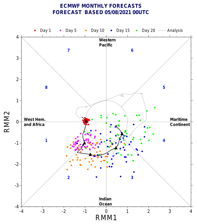
The latest ECMWF MJO forecast shows Phase I by August 6, which should mark the end of the lull period for the Atlantic. Throughout August, the MJO will cycle through Phases II, III, and IV, with Phase IV likely continuing into peak season.
captainbarbossa19 wrote:AlphaToOmega wrote:https://i.postimg.cc/FzhHzcMt/pdf2svg-worker-commands-5bcd7565f6-7gmw5-6fe5cac1a363ec1525f54343b6cc9fd8-ZFXMm-E.png
The latest ECMWF MJO forecast shows Phase I by August 6, which should mark the end of the lull period for the Atlantic. Throughout August, the MJO will cycle through Phases II, III, and IV, with Phase IV likely continuing into peak season.
August 6 is tomorrow. With 92L emerging off the coast of Africa today, I suspect that the Atlantic is about to take over with activity. It's almost that time folks!


tolakram wrote:I'm still trying to figure out why Webb thinks it's a good idea to use an adjusted anomaly graph for a predictor. The temperature needed to sustain a tropical cyclone has not changed so moving the shading around is just adding to the confusion. Anyone care to explain what I'm missing?


tolakram wrote:I couple of graphs from CSU's latest forecast.
https://i.imgur.com/rJgIEQD.png
https://i.imgur.com/x9Ov9kQ.png
In these two cases we are very close to hyperactive indicators. Note this is just two indicators they use when making a forecast.
SFLcane wrote:Overnight long range guidance is still meh… interesting the ECMWF seasonal backed off to average. Just to dry and stable right now. It's competing factors Right now La Niña and WAM vs stability plus cooler MDR (relative to the rest).
We will see when it flips.
Shell Mound wrote:The very warm subtropics likely mean that ridging, while strong, will be displaced northward during the peak of the season, allowing troughs to form underneath.SFLcane wrote:Overnight long range guidance is still meh… interesting the ECMWF seasonal backed off to average. Just to dry and stable right now. It's competing factors Right now La Niña and WAM vs stability plus cooler MDR (relative to the rest).
We will see when it flips.
Some people thought that the Niña and ASW alone would overcome the -AMM/-AMO and EPAC -VP. So far that is not the case. Wxman57's bearish outlook on the MDR will end up being correct for ASO. This goes to show that much more is needed than La Niña and a strong Africa monsoon for an above-average MDR. The fact is that the tropical Atlantic is cooler than the subtropics, so sinking air alone will be sufficient to reduce the prospects of long-trackers in the MDR. A drier Atlantic also means smaller and generally less destructive storms.
toad strangler wrote:Shell Mound wrote:The very warm subtropics likely mean that ridging, while strong, will be displaced northward during the peak of the season, allowing troughs to form underneath.SFLcane wrote:Overnight long range guidance is still meh… interesting the ECMWF seasonal backed off to average. Just to dry and stable right now. It's competing factors Right now La Niña and WAM vs stability plus cooler MDR (relative to the rest).
We will see when it flips.
Some people thought that the Niña and ASW alone would overcome the -AMM/-AMO and EPAC -VP. So far that is not the case. Wxman57's bearish outlook on the MDR will end up being correct for ASO. This goes to show that much more is needed than La Niña and a strong Africa monsoon for an above-average MDR. The fact is that the tropical Atlantic is cooler than the subtropics, so sinking air alone will be sufficient to reduce the prospects of long-trackers in the MDR. A drier Atlantic also means smaller and generally less destructive storms.
It’s August 6th
Shell Mound wrote:The very warm subtropics likely mean that ridging, while strong, will be displaced northward during the peak of the season, allowing troughs to form underneath.SFLcane wrote:Overnight long range guidance is still meh… interesting the ECMWF seasonal backed off to average. Just to dry and stable right now. It's competing factors Right now La Niña and WAM vs stability plus cooler MDR (relative to the rest).
We will see when it flips.
Some people thought that the Niña and ASW alone would overcome the -AMM/-AMO and EPAC -VP. So far that is not the case. Wxman57's bearish outlook on the MDR will end up being correct for ASO. This goes to show that much more is needed than La Niña and a strong Africa monsoon for an above-average MDR. The fact is that the tropical Atlantic is cooler than the subtropics, so sinking air alone will be sufficient to reduce the prospects of long-trackers in the MDR. A drier Atlantic also means smaller and generally less destructive storms.
Cat5James wrote:Shell Mound wrote:The very warm subtropics likely mean that ridging, while strong, will be displaced northward during the peak of the season, allowing troughs to form underneath.SFLcane wrote:Overnight long range guidance is still meh… interesting the ECMWF seasonal backed off to average. Just to dry and stable right now. It's competing factors Right now La Niña and WAM vs stability plus cooler MDR (relative to the rest).
We will see when it flips.
Some people thought that the Niña and ASW alone would overcome the -AMM/-AMO and EPAC -VP. So far that is not the case. Wxman57's bearish outlook on the MDR will end up being correct for ASO. This goes to show that much more is needed than La Niña and a strong Africa monsoon for an above-average MDR. The fact is that the tropical Atlantic is cooler than the subtropics, so sinking air alone will be sufficient to reduce the prospects of long-trackers in the MDR. A drier Atlantic also means smaller and generally less destructive storms.
"Will end up being correct"... did you just make a definitive statement about September/October on August 6th?
Shell Mound wrote:The very warm subtropics likely mean that ridging, while strong, will be displaced northward during the peak of the season, allowing troughs to form underneath.SFLcane wrote:Overnight long range guidance is still meh… interesting the ECMWF seasonal backed off to average. Just to dry and stable right now. It's competing factors Right now La Niña and WAM vs stability plus cooler MDR (relative to the rest).
We will see when it flips.
Some people thought that the Niña and ASW alone would overcome the -AMM/-AMO and EPAC -VP. So far that is not the case. Wxman57's bearish outlook on the MDR will end up being correct for ASO. This goes to show that much more is needed than La Niña and a strong Africa monsoon for an above-average MDR. The fact is that the tropical Atlantic is cooler than the subtropics, so sinking air alone will be sufficient to reduce the prospects of long-trackers in the MDR. A drier Atlantic also means smaller and generally less destructive storms.
Users browsing this forum: Google [Bot], Ulf and 235 guests
