ATL: GRACE - Models
Moderator: S2k Moderators

Re: ATL: GRACE - Models
So the Euro drops Grace and poofs her. I don't even see any remnants.
0 likes
Personal Forecast Disclaimer:
The posts in this forum are NOT official forecast and should not be used as such. They are just the opinion of the poster and may or may not be backed by sound meteorological data. They are NOT endorsed by any professional institution or storm2k.org. For official information, please refer to the NHC and NWS products.
The posts in this forum are NOT official forecast and should not be used as such. They are just the opinion of the poster and may or may not be backed by sound meteorological data. They are NOT endorsed by any professional institution or storm2k.org. For official information, please refer to the NHC and NWS products.
-
AxaltaRacing24
- Category 5

- Posts: 1774
- Age: 25
- Joined: Wed Jul 27, 2016 11:14 am
- Location: Jupiter, FL
Re: ATL: GRACE - Models
AtlanticWind wrote:AxaltaRacing24 wrote:AtlanticWind wrote:I am tending to lean to the Hwrf for path( intensity who knows) because I think Grace is moving more wnw
and is going to clear Hispanola.
We are going to find out real soon who is right.
Just to clarify I dont think its going to clear by as much as the HWRF is showing
Think its going to ride just offshore of the big Island.
But this a close call and definitely would not be suprised if it burys itself in Hispanola.
If you see a reformation N or Puerto Rico, or see it barely clip from the E, watch out. If not, then a GFS scenario comes more into play.
Last edited by AxaltaRacing24 on Sun Aug 15, 2021 1:51 am, edited 1 time in total.
1 likes
-
AtlanticWind

- S2K Supporter

- Posts: 1898
- Age: 67
- Joined: Sun Aug 08, 2004 9:57 pm
- Location: Plantation,Fla
Re: RE: Re: ATL: GRACE - Models
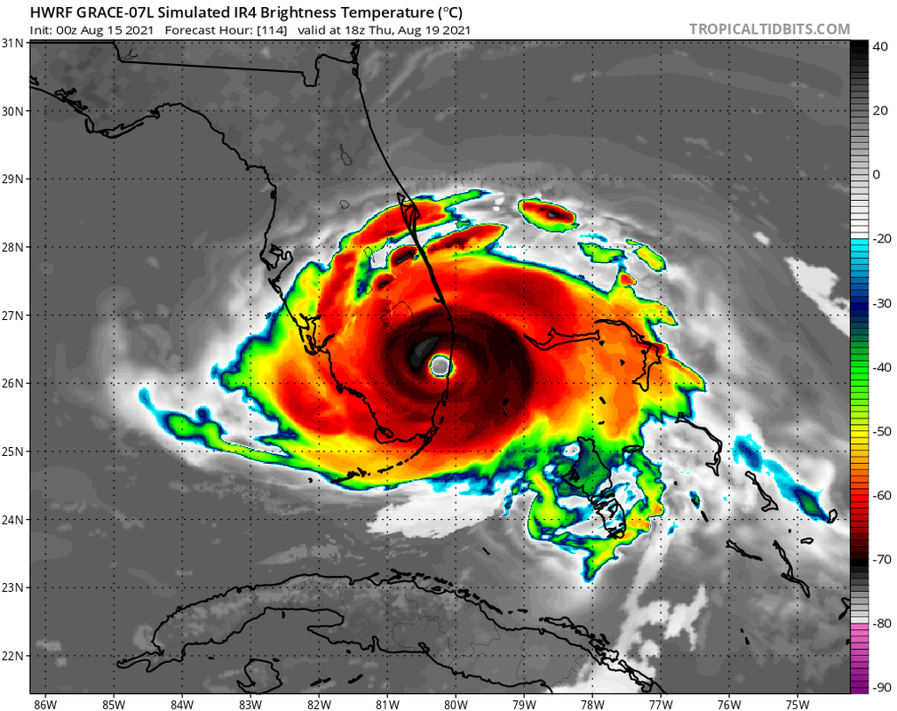
jlauderdal wrote:Its been wrong so many times, it will be right at some point.AxaltaRacing24 wrote:https://i.postimg.cc/qMFrh9h8/hwrf-sat-IR-07-L-20.png
Welp, the HWRF is definitely entertaining.
Hope this is not the time
0 likes

Re: ATL: GRACE - Models
SoupBone wrote:So the Euro drops Grace and poofs her. I don't even see any remnants.
Should you be surprised? It’s the Euro.
1 likes

Re: ATL: GRACE - Models
The global models seem to dissipate or severely weaken Grace due to a meeting with Hispaniola. Now let's see what the hurricane models will do, HMON 06z just started.
0 likes

Re: ATL: GRACE - Models
That ASCAT rules out rapid intensification.
I suppose the big islands might eventually split the system and close off some of the energy to the north.
I suppose the big islands might eventually split the system and close off some of the energy to the north.
0 likes
Re: ATL: GRACE - Models
06z HMON dissipates Grace after a landfall with Hispaniola. Seems like a Hispaniola landfall is becoming increasingly likely. Would be favorable for the US of course, but a horrible scenario for Haiti especially. Just days after the earthquake they would have TS (remnants) to deal with and the latest euro run even brings more than 200 mm of rain to certain parts of the country.
0 likes
Re: ATL: GRACE - Models
06z HWRF however still jumps north of Hispaniola, hurricane at +48 hrs. Tbh I find this a bit too crazy to believe considering the other models, but who knows. This could be quite a run.

2 likes

Re: ATL: GRACE - Models
kevin wrote:06z HWRF however still jumps north of Hispaniola, hurricane at +48 hrs. Tbh I find this a bit too crazy to believe considering the other models, but who knows. This could be quite a run.
https://i.imgur.com/nxjQ4FP.png
In order for that run to verify, we would need to see a significant shift to the NW today and a massive blowup of convection by tonight. This is probably just another popcorn run. The HWRF does have quite the north bias with its tracks.
0 likes
Irene '11 Sandy '12 Hermine '16 5/15/2018 Derecho Fay '20 Isaias '20 Elsa '21 Henri '21 Ida '21
I am only a meteorology enthusiast who knows a decent amount about tropical cyclones. Look to the professional mets, the NHC, or your local weather office for the best information.
I am only a meteorology enthusiast who knows a decent amount about tropical cyclones. Look to the professional mets, the NHC, or your local weather office for the best information.
-
tolakram
- Admin

- Posts: 20186
- Age: 62
- Joined: Sun Aug 27, 2006 8:23 pm
- Location: Florence, KY (name is Mark)
Re: ATL: GRACE - Models
How in the world does the HWRF get this thing moving rapidly NW?
0 likes
M a r k
- - - - -
Join us in chat: Storm2K Chatroom Invite. Android and IOS apps also available.
The posts in this forum are NOT official forecasts and should not be used as such. Posts are NOT endorsed by any professional institution or STORM2K.org. For official information and forecasts, please refer to NHC and NWS products.
-
tolakram
- Admin
- Posts: 20186
- Age: 62
- Joined: Sun Aug 27, 2006 8:23 pm
- Location: Florence, KY (name is Mark)
Re: ATL: GRACE - Models
6z Euro

0 likes
M a r k
- - - - -
Join us in chat: Storm2K Chatroom Invite. Android and IOS apps also available.
The posts in this forum are NOT official forecasts and should not be used as such. Posts are NOT endorsed by any professional institution or STORM2K.org. For official information and forecasts, please refer to NHC and NWS products.
- - - - -
Join us in chat: Storm2K Chatroom Invite. Android and IOS apps also available.
The posts in this forum are NOT official forecasts and should not be used as such. Posts are NOT endorsed by any professional institution or STORM2K.org. For official information and forecasts, please refer to NHC and NWS products.
Re: ATL: GRACE - Models
The 06z HWRF-P run for 96L shows a much more believable outcome for Grace: it remains weak while traveling over the GAs, has a center relocation into the northern coast of Cuba/FL straits, and emerges in the Gulf as a weak TS/TD before intensifying again.
In other words, Laura 2.0
In other words, Laura 2.0
1 likes
Irene '11 Sandy '12 Hermine '16 5/15/2018 Derecho Fay '20 Isaias '20 Elsa '21 Henri '21 Ida '21
I am only a meteorology enthusiast who knows a decent amount about tropical cyclones. Look to the professional mets, the NHC, or your local weather office for the best information.
I am only a meteorology enthusiast who knows a decent amount about tropical cyclones. Look to the professional mets, the NHC, or your local weather office for the best information.
-
Hypercane_Kyle

- Category 5
- Posts: 3465
- Joined: Sat Mar 07, 2015 7:58 pm
- Location: Cape Canaveral, FL
Re: ATL: GRACE - Models

0 likes
My posts are my own personal opinion, defer to the National Hurricane Center (NHC) and other NOAA products for decision making during hurricane season.
Re: ATL: GRACE - Models
Why the crazy eyes, that's a pretty reasonable solution. A minimal system hitting with Texas.
0 likes
Personal Forecast Disclaimer:
The posts in this forum are NOT official forecast and should not be used as such. They are just the opinion of the poster and may or may not be backed by sound meteorological data. They are NOT endorsed by any professional institution or storm2k.org. For official information, please refer to the NHC and NWS products.
The posts in this forum are NOT official forecast and should not be used as such. They are just the opinion of the poster and may or may not be backed by sound meteorological data. They are NOT endorsed by any professional institution or storm2k.org. For official information, please refer to the NHC and NWS products.
-
Hypercane_Kyle
- Category 5
- Posts: 3465
- Joined: Sat Mar 07, 2015 7:58 pm
- Location: Cape Canaveral, FL
Re: ATL: GRACE - Models
SoupBone wrote:
Why the crazy eyes, that's a pretty reasonable solution. A minimal system hitting with Texas.
I wouldn't call that solution "minimal". What the GEFS is showing is that Grace could struggle over Hispaniola & Cuba and still become a potent system in the GOMEX.
1 likes
My posts are my own personal opinion, defer to the National Hurricane Center (NHC) and other NOAA products for decision making during hurricane season.
-
toad strangler

- S2K Supporter
- Posts: 4546
- Joined: Sun Jul 28, 2013 3:09 pm
- Location: Earth
- Contact:
Re: ATL: GRACE - Models
I view any post GA's interaction model output with a whole one pound package of Celtic Sea Salt
2 likes
My Weather Station
https://www.wunderground.com/dashboard/pws/KFLPORTS603
https://www.wunderground.com/dashboard/pws/KFLPORTS603

Re: ATL: GRACE - Models
06z Euro ensembles.
If it tracks north of Cuba chances of getting strong is greater, will have better UL conditions than what Fred had.

If it tracks north of Cuba chances of getting strong is greater, will have better UL conditions than what Fred had.
Last edited by NDG on Sun Aug 15, 2021 8:58 am, edited 1 time in total.
0 likes


Re: ATL: GRACE - Models
NDG wrote:06z Euro ensembles.
If it tracks north of Cuba chances of getting strong is greater, will have better UL conditions than what Fred had.
https://i.imgur.com/1z5L5T4.png
How many models are showing this GOM solution? I think I saw this one and GFS.
0 likes
Re: ATL: GRACE - Models
NDG wrote:06z Euro ensembles.
If it tracks north of Cuba chances of getting strong is greater, will have better UL conditions than what Fred had.
https://i.imgur.com/1z5L5T4.png
Funny that the Euro last night completely lost Grace. And it doesn't have the potent high that the GFS thinks will be in the Gulf.
Last edited by SoupBone on Sun Aug 15, 2021 9:24 am, edited 1 time in total.
0 likes
Personal Forecast Disclaimer:
The posts in this forum are NOT official forecast and should not be used as such. They are just the opinion of the poster and may or may not be backed by sound meteorological data. They are NOT endorsed by any professional institution or storm2k.org. For official information, please refer to the NHC and NWS products.
The posts in this forum are NOT official forecast and should not be used as such. They are just the opinion of the poster and may or may not be backed by sound meteorological data. They are NOT endorsed by any professional institution or storm2k.org. For official information, please refer to the NHC and NWS products.
Who is online
Users browsing this forum: No registered users and 27 guests