
Based on the model runs of the last day, we might be looking at three more storms forming in the next 10 days:
—Ida in the MDR and recurving early (Euro operational and ensembles)
—Julian in the MDR, either recurving like Ida or being far enough south to continue west (Euro/GEFS ensembles and CMC)
—Kate in the WCar and/or Gulf of Mexico from a CAG-like feature (GFS, GEFS/Euro ensembles, CMC)
Six storms in August would be way more than I would’ve anticipated. Seems like the bell is already ringing.
If the 0/20 disturbance doesn’t become Ida, then there won’t be much of a break in the ridge to drag the following wave north. That might be one to watch in the last week of August.
2021 Indicators: SST's / SAL / MSLP / Shear / Steering / Instability / Sat Images
Moderator: S2k Moderators
Forum rules

The posts in this forum are NOT official forecasts and should not be used as such. They are just the opinion of the poster and may or may not be backed by sound meteorological data. They are NOT endorsed by any professional institution or STORM2K. For official information, please refer to products from the National Hurricane Center and National Weather Service.
Re: 2021 Indicators: SST's / SAL / MSLP / Shear / Steering / Instability / Sat Images
5 likes
Irene '11 Sandy '12 Hermine '16 5/15/2018 Derecho Fay '20 Isaias '20 Elsa '21 Henri '21 Ida '21
I am only a meteorology enthusiast who knows a decent amount about tropical cyclones. Look to the professional mets, the NHC, or your local weather office for the best information.
I am only a meteorology enthusiast who knows a decent amount about tropical cyclones. Look to the professional mets, the NHC, or your local weather office for the best information.
-
AlphaToOmega
- Category 5

- Posts: 1448
- Joined: Sat Jun 26, 2021 10:51 am
- Location: Somewhere in Massachusetts
Re: 2021 Indicators: SST's / SAL / MSLP / Shear / Steering / Instability / Sat Images
If we get another 3 storms in August, that puts us at 11 storms. An extremely favorable September and October setup could easily get us over 25 storms by the end of this season.
0 likes
-
CyclonicFury

- Category 5
- Posts: 2035
- Age: 27
- Joined: Sun Jul 02, 2017 12:32 pm
- Location: NC
- Contact:
Re: 2021 Indicators: SST's / SAL / MSLP / Shear / Steering / Instability / Sat Images
AlphaToOmega wrote:If we get another 3 storms in August, that puts us at 11 storms. An extremely favorable September and October setup could easily get us over 25 storms by the end of this season.
Over 25 storms is a stretch. It's going to be very difficult to replicate 2020's record breaking storm numbers. I could see us getting near the end of the naming list though.
1 likes
NCSU B.S. in Meteorology Class of 2021. Tropical weather blogger at http://www.cyclonicfury.com. My forecasts and thoughts are NOT official, for official forecasts please consult the National Hurricane Center.
Re: 2021 Indicators: SST's / SAL / MSLP / Shear / Steering / Instability / Sat Images
CyclonicFury wrote:AlphaToOmega wrote:If we get another 3 storms in August, that puts us at 11 storms. An extremely favorable September and October setup could easily get us over 25 storms by the end of this season.
Over 25 storms is a stretch. It's going to be very difficult to replicate 2020's record breaking storm numbers. I could see us getting near the end of the naming list though.
If we get these 3 additional storms, plus 7 in September and 4 in the rest of the year (the La Niña will probably make the late season more active than normal), we’d hit 22 named storms. 20-25 is a possibility, but over 25 is unlikely unless we get a record-tying rest of the year.
0 likes
Irene '11 Sandy '12 Hermine '16 5/15/2018 Derecho Fay '20 Isaias '20 Elsa '21 Henri '21 Ida '21
I am only a meteorology enthusiast who knows a decent amount about tropical cyclones. Look to the professional mets, the NHC, or your local weather office for the best information.
I am only a meteorology enthusiast who knows a decent amount about tropical cyclones. Look to the professional mets, the NHC, or your local weather office for the best information.
-
CYCLONE MIKE
- Category 5
- Posts: 2183
- Joined: Tue Aug 31, 2004 6:04 pm
- Location: Gonzales, LA
Re: 2021 Indicators: SST's / SAL / MSLP / Shear / Steering / Instability / Sat Images
CyclonicFury wrote:AlphaToOmega wrote:If we get another 3 storms in August, that puts us at 11 storms. An extremely favorable September and October setup could easily get us over 25 storms by the end of this season.
Over 25 storms is a stretch. It's going to be very difficult to replicate 2020's record breaking storm numbers. I could see us getting near the end of the naming list though.
Before I begin to believe there is a minuscule chance we could see anything close to 2020 I want to see 3 more in 10 days. That would be almost as impressive.
0 likes
-
Category5Kaiju

- Category 5
- Posts: 4335
- Joined: Thu Dec 24, 2020 12:45 pm
- Location: Seattle during the summer, Phoenix during the winter
Re: 2021 Indicators: SST's / SAL / MSLP / Shear / Steering / Instability / Sat Images
WiscoWx02 wrote:NotSparta wrote:Shell Mound wrote:I think these two factors will combine to prevent a significant rise in strong activity during climatological the peak of the season. So far the MJO has not helped.
Hmm, I better head to the doctor. Must have imagined a TS and a hurricane in the deep tropics but it seems in reality there has been no deep tropical activity
Definitely cannot ignore Elsa and Grace forming, I agree with that. I do agree with Shellmound however that this could be a backloaded season. Sure we will see plenty of new stuff maybe not the end of this month but September for sure. But I think the real beef is going to be served in October. Been the new trend over the last several years IMO. I would even argue that the peak of last hurricane season was October and November, not September. Not saying September last year wasn't busy cause it was! However, I think October and early November took home the cake on peak activity, with all those major hurricanes. This year and last year are kinda similar as well in terms of present conditions. Just my take on it though.
In many recent years at least since 2011, the strongest hurricane of the season did not occur until after the peak season time of September 10.
1 likes
Unless explicitly stated, all information in my posts is based on my own opinions and observations. Tropical storms and hurricanes can be extremely dangerous. Refer to an accredited weather research agency or meteorologist if you need to make serious decisions regarding an approaching storm.
-
AlphaToOmega
- Category 5
- Posts: 1448
- Joined: Sat Jun 26, 2021 10:51 am
- Location: Somewhere in Massachusetts

Re: 2021 Indicators: SST's / SAL / MSLP / Shear / Steering / Instability / Sat Images
Shell Mound wrote:Teban54 wrote:Shell Mound wrote:If there is still no sign of substantial activity come Dr. Gray’s “bell-ringing” date of 20 August, then I would expect much lower numbers and seasonal ACE.
There was pretty much no substantial activity on August 20 itself and before that date (aside from mostly TS and a few weak/OTS hurricanes) in 2017, 2018, 2019 and 2020, and we all know how those years turned out.
Most hyperactive seasons either had more activity earlier in August or featured a cluster of storms developing within a few days of 20 August (or both). The former:
.........Year............# TS 1–19 AugustThe latter:
- 1969............3
- 1886............2
- 1932............1
- 2003............1
- 2020............2
- 1887............2
- 1950............2
- 2017............3
- 2004............4
- 1995............2
- 1896............4
- 2005............2
- 1933............2
1961 was an exception, in that it did not feature a single NS during August, yet ended up as a hyperactive season nonetheless. September 1961 was quite active.
- 1906: 22 August
- 2010: 21 August
- 1996: 19 August
- 1964: 20 August
- 1999: 18 August
- 1878: 19 August
- 1998: 19 August
- 1926: 20 August
I reiterate: if we do not see a NS on or before 20 August and/or there is no sign of a change by that date, then I would expect a much less active year than forecast.
It's the last advisory before August 20. Since the above post was made on August 8, we have:
- Fred, which went from a remnant low to a high-end TS almost a hurricane all in the Gulf
- Grace, which hit Mexico as a hurricane and is forecast to make another landfall, possibly at a much higher intensity
- Henri, which might have been a brief hurricane and is forecast to officially become one soon, as it traverses the Gulf Stream before impacting an area that rarely sees direct landfalls
- A 0/20 AOI SW of Cabo Verde that some models hint at becoming an OTS CV storm
- Up to three more modeled storms: a Caribbean/Gulf homegrown, a storm of subtropical origin, and another wave behind the 0/20 AOI
Also, while the NHC forecasts do not show this, there's a real possibility that we see at least one major from Grace and Henri.
It's up to the reader to determine how much this post above has busted.
10 likes
TC naming lists: retirements and intensity
Most aggressive Advisory #1's in North Atlantic (cr. kevin for starting the list)
Most aggressive Advisory #1's in North Atlantic (cr. kevin for starting the list)
-
NotSparta

- Professional-Met

- Posts: 1677
- Age: 24
- Joined: Fri Aug 18, 2017 8:24 am
- Location: Naples, FL
- Contact:
Re: 2021 Indicators: SST's / SAL / MSLP / Shear / Steering / Instability / Sat Images
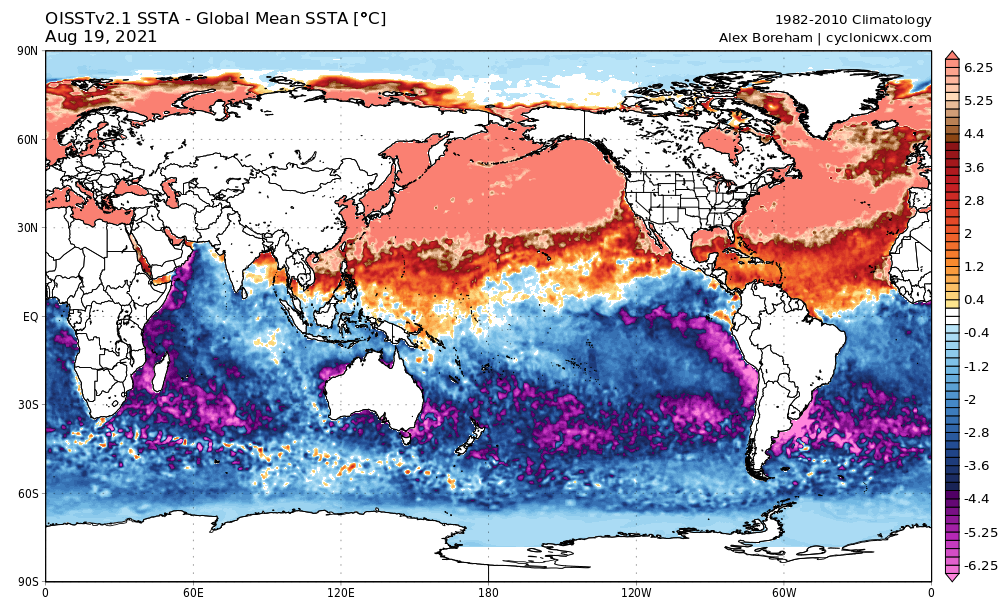
AlphaToOmega wrote:https://i.postimg.cc/NMPKgVbs/sstamean-global.png
LOL, not sure what happened. Unfortunately rather busy today and the next couple days so hopefully that issue sorts itself out tomorrow
0 likes
This post was probably an opinion of mine, and in no way is official. Please refer to http://www.hurricanes.gov for official tropical analysis and advisories.
My website, with lots of tropical wx graphics, including satellite and recon: http://cyclonicwx.com
My website, with lots of tropical wx graphics, including satellite and recon: http://cyclonicwx.com

Re: 2021 Indicators: SST's / SAL / MSLP / Shear / Steering / Instability / Sat Images
AlphaToOmega wrote:If we get another 3 storms in August, that puts us at 11 storms. An extremely favorable September and October setup could easily get us over 25 storms by the end of this season.
That would likely require everything after this point being as active than last year at minimum--we were already at 15 storms just a day or two into September.
0 likes
The above post is not official and should not be used as such. It is the opinion of the poster and may or may not be backed by sound meteorological data. It is not endorsed by any professional institution or storm2k.org. For official information, please refer to the NHC and NWS products.
Re: 2021 Indicators: SST's / SAL / MSLP / Shear / Steering / Instability / Sat Images
aspen wrote:I’m starting to wonder if we’ll have to wait until September for the first sub-990 mbar storm of the season, if the African monsoon remains too strong for development east of 50W and the ridging is positioned in just the right way to put everything on a track into the islands.
Imagine if that little low pressure system near Bermuda with barely any model support ends up as a stronger system than either Fred or Grace lol
Looks like we are going to have two sub 990 MB systems with over a week left in August.
2 likes


Re: 2021 Indicators: SST's / SAL / MSLP / Shear / Steering / Instability / Sat Images
Certainly feels like the bell has been rung. We have two strong TS's that both are likely to become potent hurricanes.psyclone wrote:DING!
0 likes
-
AlphaToOmega
- Category 5
- Posts: 1448
- Joined: Sat Jun 26, 2021 10:51 am
- Location: Somewhere in Massachusetts
Re: 2021 Indicators: SST's / SAL / MSLP / Shear / Steering / Instability / Sat Images
Favorable signal for the rest of the season
The climate models are going to have to bust in a major way if this season is not going to be hyperactive, which is very easy to achieve with this VP anomaly pattern.
The climate models are going to have to bust in a major way if this season is not going to be hyperactive, which is very easy to achieve with this VP anomaly pattern.
0 likes
-
gatorcane

- S2K Supporter

- Posts: 23708
- Age: 48
- Joined: Sun Mar 13, 2005 3:54 pm
- Location: Boca Raton, FL
Re: 2021 Indicators: SST's / SAL / MSLP / Shear / Steering / Instability / Sat Images
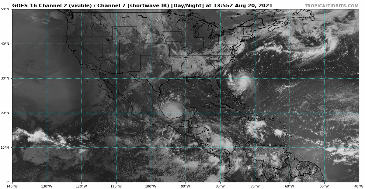
Here we are with the bell ringing on Aug 20th. The MDR Cape Verde region including the Caribbean is a ghost town and looks to be so for at least the next week if the models are correct. The Western Caribbean gets a pass since Grace just went through there. We can see a couple of waves but a lot of dust also keeping a lid on Cape Verde development for now:
5 likes
-
Shell Mound
- Category 5
- Posts: 2432
- Age: 33
- Joined: Thu Sep 07, 2017 3:39 pm
- Location: St. Petersburg, FL → Scandinavia
Re: 2021 Indicators: SST's / SAL / MSLP / Shear / Steering / Instability / Sat Images
Teban54 wrote:Shell Mound wrote:Teban54 wrote:There was pretty much no substantial activity on August 20 itself and before that date (aside from mostly TS and a few weak/OTS hurricanes) in 2017, 2018, 2019 and 2020, and we all know how those years turned out.
Most hyperactive seasons either had more activity earlier in August or featured a cluster of storms developing within a few days of 20 August (or both). The former:
.........Year............# TS 1–19 AugustThe latter:
- 1969............3
- 1886............2
- 1932............1
- 2003............1
- 2020............2
- 1887............2
- 1950............2
- 2017............3
- 2004............4
- 1995............2
- 1896............4
- 2005............2
- 1933............2
...
- 1906: 22 August
- 2010: 21 August
- 1996: 19 August
- 1964: 20 August
- 1999: 18 August
- 1878: 19 August
- 1998: 19 August
- 1926: 20 August
Only Grace has met or exceeded expectations to date. The other systems have mostly underperformed, including Henri. Lots of modelled Category-2+ hurricanes failed to verify in these and other cases. The basin remains too hostile for Category-2+ systems, especially in the deep tropics. So far there is no clear indication that the MDR will become sufficiently favourable to allow for a system to form and attain major-hurricane status between the islands and West Africa, much less become a long-tracking, high-ACE producer. I don’t really care about total NS, given that those numbers tend to be artificially inflated—many “questionable” systems being classified nowadays—and do not really reflect the “intensity” of a season as well as ACE does.
0 likes
CVW / MiamiensisWx / Shell Mound
The posts in this forum are NOT official forecasts and should not be used as such. They are just the opinion of the poster and may or may not be backed by sound meteorological data. They are NOT endorsed by any professional institution or STORM2K. For official information, please refer to products from the NHC and NWS.
-
CyclonicFury
- Category 5
- Posts: 2035
- Age: 27
- Joined: Sun Jul 02, 2017 12:32 pm
- Location: NC
- Contact:
Re: 2021 Indicators: SST's / SAL / MSLP / Shear / Steering / Instability / Sat Images
Shell Mound wrote:Teban54 wrote:Shell Mound wrote:Most hyperactive seasons either had more activity earlier in August or featured a cluster of storms developing within a few days of 20 August (or both). The former:
.........Year............# TS 1–19 AugustThe latter:
- 1969............3
- 1886............2
- 1932............1
- 2003............1
- 2020............2
- 1887............2
- 1950............2
- 2017............3
- 2004............4
- 1995............2
- 1896............4
- 2005............2
- 1933............2
...
- 1906: 22 August
- 2010: 21 August
- 1996: 19 August
- 1964: 20 August
- 1999: 18 August
- 1878: 19 August
- 1998: 19 August
- 1926: 20 August
Only Grace has met or exceeded expectations to date. The other systems have mostly underperformed, including Henri. Lots of modelled Category-2+ hurricanes failed to verify in these and other cases. The basin remains too hostile for Category-2+ systems, especially in the deep tropics. So far there is no clear indication that the MDR will become sufficiently favourable to allow for a system to form and attain major-hurricane status between the islands and West Africa, much less become a long-tracking, high-ACE producer. I don’t really care about total NS, given that those numbers tend to be artificially inflated—many “questionable” systems being classified nowadays—and do not really reflect the “intensity” of a season as well as ACE does.
Grace is expected to become a Category 2 hurricane today.
8 likes
NCSU B.S. in Meteorology Class of 2021. Tropical weather blogger at http://www.cyclonicfury.com. My forecasts and thoughts are NOT official, for official forecasts please consult the National Hurricane Center.
-
captainbarbossa19

- Professional-Met
- Posts: 1094
- Age: 27
- Joined: Wed Aug 21, 2019 11:09 pm
- Location: Beaumont, TX
Re: 2021 Indicators: SST's / SAL / MSLP / Shear / Steering / Instability / Sat Images
Shell Mound wrote:Teban54 wrote:Shell Mound wrote:Most hyperactive seasons either had more activity earlier in August or featured a cluster of storms developing within a few days of 20 August (or both). The former:
.........Year............# TS 1–19 AugustThe latter:
- 1969............3
- 1886............2
- 1932............1
- 2003............1
- 2020............2
- 1887............2
- 1950............2
- 2017............3
- 2004............4
- 1995............2
- 1896............4
- 2005............2
- 1933............2
...
- 1906: 22 August
- 2010: 21 August
- 1996: 19 August
- 1964: 20 August
- 1999: 18 August
- 1878: 19 August
- 1998: 19 August
- 1926: 20 August
Only Grace has met or exceeded expectations to date. The other systems have mostly underperformed, including Henri. Lots of modelled Category-2+ hurricanes failed to verify in these and other cases. The basin remains too hostile for Category-2+ systems, especially in the deep tropics. So far there is no clear indication that the MDR will become sufficiently favourable to allow for a system to form and attain major-hurricane status between the islands and West Africa, much less become a long-tracking, high-ACE producer. I don’t really care about total NS, given that those numbers tend to be artificially inflated—many “questionable” systems being classified nowadays—and do not really reflect the “intensity” of a season as well as ACE does.
Let's revisit this on September 30th. On average, the first major hurricane does not even develop until September.
8 likes
-
MarioProtVI
- Category 5
- Posts: 1034
- Age: 24
- Joined: Sun Sep 29, 2019 7:33 pm
- Location: New Jersey
Re: 2021 Indicators: SST's / SAL / MSLP / Shear / Steering / Instability / Sat Images
Shell Mound wrote:Teban54 wrote:Shell Mound wrote:Most hyperactive seasons either had more activity earlier in August or featured a cluster of storms developing within a few days of 20 August (or both). The former:
.........Year............# TS 1–19 AugustThe latter:
- 1969............3
- 1886............2
- 1932............1
- 2003............1
- 2020............2
- 1887............2
- 1950............2
- 2017............3
- 2004............4
- 1995............2
- 1896............4
- 2005............2
- 1933............2
...
- 1906: 22 August
- 2010: 21 August
- 1996: 19 August
- 1964: 20 August
- 1999: 18 August
- 1878: 19 August
- 1998: 19 August
- 1926: 20 August
Only Grace has met or exceeded expectations to date. The other systems have mostly underperformed, including Henri. Lots of modelled Category-2+ hurricanes failed to verify in these and other cases. The basin remains too hostile for Category-2+ systems, especially in the deep tropics. So far there is no clear indication that the MDR will become sufficiently favourable to allow for a system to form and attain major-hurricane status between the islands and West Africa, much less become a long-tracking, high-ACE producer. I don’t really care about total NS, given that those numbers tend to be artificially inflated—many “questionable” systems being classified nowadays—and do not really reflect the “intensity” of a season as well as ACE does.
What is it with the negative Nancy posts? It’s August 20 and for one Grace is very close to becoming a C2 and the only storms modeled to become C2 besides Grace and Henri were systems that did not have any recon data which makes the HWRF highly overestimate it especially in the MDR/Caribbean. We are just about heading into the peak now and all signs point to an active September. And those “questionable systems” are actually storms that we can now detect because we have better technology - it doesn’t matter how short it lives - if the NHC says it’s a TC it’s a TC. Conditions across the basin can change to a more favorable pattern without warning - look at 2017. I’m sorry but a lot of these posts haven’t verified, such as the one last year about a “wall of shear” in the Caribbean only for late season to produce its most active and most intense season there since 2010 and 2005 with three majors all C3+ (one which was most likely a C5 and one that got close). Sorry bud, 2021 ain’t as -AMO as you think.
10 likes
-
tolakram
- Admin

- Posts: 20186
- Age: 62
- Joined: Sun Aug 27, 2006 8:23 pm
- Location: Florence, KY (name is Mark)
Re: 2021 Indicators: SST's / SAL / MSLP / Shear / Steering / Instability / Sat Images
Shell Mound wrote:Only Grace has met or exceeded expectations to date. The other systems have mostly underperformed, including Henri. Lots of modelled Category-2+ hurricanes failed to verify in these and other cases. The basin remains too hostile for Category-2+ systems, especially in the deep tropics. So far there is no clear indication that the MDR will become sufficiently favourable to allow for a system to form and attain major-hurricane status between the islands and West Africa, much less become a long-tracking, high-ACE producer. I don’t really care about total NS, given that those numbers tend to be artificially inflated—many “questionable” systems being classified nowadays—and do not really reflect the “intensity” of a season as well as ACE does.
I reject the implication of artificially inflated. Totally reject it, and I'm tired, frankly, of not calling people out in the public forums. Technology is updated, storm counts reflect that. It's downright absurd to think 'questionable' storms should not be called storms and instead someone have to think about ... hey Bob, would we have named this 20 years ago? Gosh, if we name this will the media somehow misinterpret things?
ABSURD. I agree storm counts are rather meaningless, but I reject the accusation that these are questionable.
The NHC missions statement makes perfectly clear what their job is.
18 likes
M a r k
- - - - -
Join us in chat: Storm2K Chatroom Invite. Android and IOS apps also available.
The posts in this forum are NOT official forecasts and should not be used as such. Posts are NOT endorsed by any professional institution or STORM2K.org. For official information and forecasts, please refer to NHC and NWS products.
Who is online
Users browsing this forum: No registered users and 419 guests