2021 Global Model Runs Discussion (Out thru day 16)

This is the general tropical discussion area. Anyone can take their shot at predicting a storms path.

Moderator: S2k Moderators

Forum rules

The posts in this forum are NOT official forecasts and should not be used as such. They are just the opinion of the poster and may or may not be backed by sound meteorological data. They are NOT endorsed by any professional institution or STORM2K. For official information, please refer to products from the National Hurricane Center and National Weather Service.

Help Support Storm2K
Message
Author
User avatar
gatorcane
S2K Supporter
S2K Supporter
Posts: 23691
Age: 47
Joined: Sun Mar 13, 2005 3:54 pm
Location: Boca Raton, FL

Re: 2021 Global Model Runs Discussion (Out thru day 16)@

#741 Postby gatorcane » Sat Aug 21, 2021 6:54 am

ForexTidbits wrote:
gatorcane wrote:


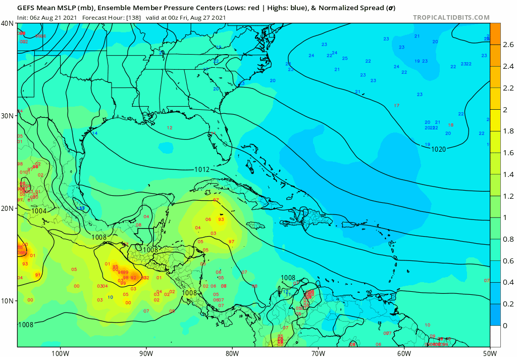
The GEFS looks to have woken up with WCAR/BOC/WGOM development which aligns with the CMC/GEPS/EPS.I don’t buy the GFS Florida storm in fantasy land which looks like more of an October track not to mention an outlier.

https://i.postimg.cc/8CWPmS7J/gfs-ememb-lowlocs-watl-fh138-204.gif


GEFS Ensemble has been very consistent on this idea as well as some ECENS ensemble coming on board on some runs as well. I would prefer following ensemble data as it provides a more broad picture instead of just one model run.


Agreed. The other point is that the GFS Florida storm at 300+ hours is another storm that the model forms after forming a storm which heads into the BOC and landfalls in Mexico like the models are doing. The Florida storm will probably be gone in the next run. Bottom-line: WCAR/BOC/WGOM development looks increasingly possible.
1 likes   

User avatar
aspen
Category 5
Category 5
Posts: 8818
Joined: Sat Oct 12, 2019 7:10 pm
Location: Connecticut, USA

Re: 2021 Global Model Runs Discussion (Out thru day 16)

#742 Postby aspen » Sat Aug 21, 2021 7:12 am

Models don’t really like the 0/20 AOI, but the ensembles suggest the wave behind it will have a better shot. All of the operational and ensemble models show Gulf development next week, and seeing how quickly Grace blew up into a 110 kt major, future Julian will certainly be one to watch. If it remains very broad like some models show, it’ll probably just be a sloppy rainy TS. If it ends up as a regular compact storm, watch out.
0 likes   
Irene '11 Sandy '12 Hermine '16 5/15/2018 Derecho Fay '20 Isaias '20 Elsa '21 Henri '21 Ida '21

I am only a meteorology enthusiast who knows a decent amount about tropical cyclones. Look to the professional mets, the NHC, or your local weather office for the best information.

User avatar
SoupBone
Category 5
Category 5
Posts: 3111
Joined: Tue Sep 20, 2005 5:24 pm

Re: 2021 Global Model Runs Discussion (Out thru day 16)

#743 Postby SoupBone » Sat Aug 21, 2021 10:37 am

Dumb question, but on TropicalTidbits, what settings do I use for the ensembles that can produce a meaningful graphic? I don't see much at the various settings I've tried. Or do I need to look for a paid service?
0 likes   
Personal Forecast Disclaimer:
The posts in this forum are NOT official forecast and should not be used as such. They are just the opinion of the poster and may or may not be backed by sound meteorological data. They are NOT endorsed by any professional institution or storm2k.org. For official information, please refer to the NHC and NWS products.

User avatar
Clearcloudz
Category 2
Category 2
Posts: 540
Joined: Sun Jun 10, 2018 1:46 pm
Location: Rosenberg TX

Re: 2021 Global Model Runs Discussion (Out thru day 16)

#744 Postby Clearcloudz » Sat Aug 21, 2021 10:49 am

SoupBone wrote:Dumb question, but on TropicalTidbits, what settings do I use for the ensembles that can produce a meaningful graphic? I don't see much at the various settings I've tried. Or do I need to look for a paid service?


On the ensemble page click on lower dynamics and then all the way at the bottom is ensemble mlsps.
2 likes   

User avatar
Cpv17
Category 5
Category 5
Posts: 4979
Joined: Wed Dec 07, 2016 2:24 pm
Location: Wharton/El Campo, TX

Re: 2021 Global Model Runs Discussion (Out thru day 16)

#745 Postby Cpv17 » Sat Aug 21, 2021 10:53 am

SoupBone wrote:Dumb question, but on TropicalTidbits, what settings do I use for the ensembles that can produce a meaningful graphic? I don't see much at the various settings I've tried. Or do I need to look for a paid service?


The 6z GEFS isn’t pretty for southeast Texas I can tell you that much. Even has a few strong members into Louisiana. The op is completely different, what gives?
0 likes   

User avatar
cheezyWXguy
Category 5
Category 5
Posts: 6108
Joined: Mon Feb 13, 2006 12:29 am
Location: Dallas, TX

Re: 2021 Global Model Runs Discussion (Out thru day 16)

#746 Postby cheezyWXguy » Sat Aug 21, 2021 10:54 am

Wow, the 6z GEFS ensemble… the strength of some of those members moving into Texas gives me chills. The signal starts in the southern Caribbean in only about 5 days.
2 likes   

User avatar
Clearcloudz
Category 2
Category 2
Posts: 540
Joined: Sun Jun 10, 2018 1:46 pm
Location: Rosenberg TX

Re: 2021 Global Model Runs Discussion (Out thru day 16)

#747 Postby Clearcloudz » Sat Aug 21, 2021 11:18 am


06Z gfs ensemble run.
1 likes   

User avatar
Cpv17
Category 5
Category 5
Posts: 4979
Joined: Wed Dec 07, 2016 2:24 pm
Location: Wharton/El Campo, TX

Re: 2021 Global Model Runs Discussion (Out thru day 16)

#748 Postby Cpv17 » Sat Aug 21, 2021 11:42 am

The 12z ICON looks like it wants to develop something in the central Gulf at the end of its run.
0 likes   

User avatar
SoupBone
Category 5
Category 5
Posts: 3111
Joined: Tue Sep 20, 2005 5:24 pm

Re: 2021 Global Model Runs Discussion (Out thru day 16)

#749 Postby SoupBone » Sat Aug 21, 2021 11:48 am

The GFS has been pretty consistent in sending something into Central Mexico now for at least 5-6 runs.
0 likes   
Personal Forecast Disclaimer:
The posts in this forum are NOT official forecast and should not be used as such. They are just the opinion of the poster and may or may not be backed by sound meteorological data. They are NOT endorsed by any professional institution or storm2k.org. For official information, please refer to the NHC and NWS products.

IcyTundra
Category 5
Category 5
Posts: 1205
Joined: Mon Jun 07, 2021 9:32 pm
Location: Dickinson, Texas

Re: 2021 Global Model Runs Discussion (Out thru day 16)

#750 Postby IcyTundra » Sat Aug 21, 2021 11:54 am

https://imgur.com/a/ZvvDH5A

https://imgur.com/a/xIEgg2V


12Z CMC with a 980 MB hurricane into Matagorda Bay with a massive wind field.
1 likes   

User avatar
Clearcloudz
Category 2
Category 2
Posts: 540
Joined: Sun Jun 10, 2018 1:46 pm
Location: Rosenberg TX

Re: 2021 Global Model Runs Discussion (Out thru day 16)

#751 Postby Clearcloudz » Sat Aug 21, 2021 12:02 pm

IcyTundra wrote:https://imgur.com/a/ZvvDH5A

https://imgur.com/a/xIEgg2V


12Z CMC with a 980 MB hurricane into Matagorda Bay with a massive wind field.


lol that would be a nightmare scenario for Houston and Galveston areas.
0 likes   

User avatar
Cpv17
Category 5
Category 5
Posts: 4979
Joined: Wed Dec 07, 2016 2:24 pm
Location: Wharton/El Campo, TX

Re: 2021 Global Model Runs Discussion (Out thru day 16)

#752 Postby Cpv17 » Sat Aug 21, 2021 12:06 pm

SoupBone wrote:The GFS has been pretty consistent in sending something into Central Mexico now for at least 5-6 runs.


A lot of other guidance suggest something further north.
0 likes   

User avatar
SoupBone
Category 5
Category 5
Posts: 3111
Joined: Tue Sep 20, 2005 5:24 pm

Re: 2021 Global Model Runs Discussion (Out thru day 16)

#753 Postby SoupBone » Sat Aug 21, 2021 12:09 pm

Cpv17 wrote:
SoupBone wrote:The GFS has been pretty consistent in sending something into Central Mexico now for at least 5-6 runs.


A lot of other guidance suggest something further north.


I'm posting about that actual run. It's been the most consistent thus far. Though according to Wxman, it performed very poorly for Grace.
0 likes   
Personal Forecast Disclaimer:
The posts in this forum are NOT official forecast and should not be used as such. They are just the opinion of the poster and may or may not be backed by sound meteorological data. They are NOT endorsed by any professional institution or storm2k.org. For official information, please refer to the NHC and NWS products.

User avatar
SoupBone
Category 5
Category 5
Posts: 3111
Joined: Tue Sep 20, 2005 5:24 pm

Re: 2021 Global Model Runs Discussion (Out thru day 16)

#754 Postby SoupBone » Sat Aug 21, 2021 12:12 pm

The GEFS is sending some energy toward Louisiana, but most are coming toward Mexico and Southern Texas on the 29th. BTW, why are we the only ones posting about this? :lol:
0 likes   
Personal Forecast Disclaimer:
The posts in this forum are NOT official forecast and should not be used as such. They are just the opinion of the poster and may or may not be backed by sound meteorological data. They are NOT endorsed by any professional institution or storm2k.org. For official information, please refer to the NHC and NWS products.

User avatar
Cpv17
Category 5
Category 5
Posts: 4979
Joined: Wed Dec 07, 2016 2:24 pm
Location: Wharton/El Campo, TX

Re: 2021 Global Model Runs Discussion (Out thru day 16)

#755 Postby Cpv17 » Sat Aug 21, 2021 12:21 pm

SoupBone wrote:The GEFS is sending some energy toward Louisiana, but most are coming toward Mexico and Southern Texas on the 29th. BTW, why are we the only ones posting about this? :lol:


Because it’s not an east coast or Florida threat. Not many members on here from Texas it seems like.
1 likes   

User avatar
SoupBone
Category 5
Category 5
Posts: 3111
Joined: Tue Sep 20, 2005 5:24 pm

Re: 2021 Global Model Runs Discussion (Out thru day 16)

#756 Postby SoupBone » Sat Aug 21, 2021 12:25 pm

So what's interesting about the GEFS run is that as the models start to converge on the central Mexico coast on the 29th, they suddenly shift north and look to be heading toward Corpus Christi. Is that a trough digging or something?
0 likes   
Personal Forecast Disclaimer:
The posts in this forum are NOT official forecast and should not be used as such. They are just the opinion of the poster and may or may not be backed by sound meteorological data. They are NOT endorsed by any professional institution or storm2k.org. For official information, please refer to the NHC and NWS products.

User avatar
AnnularCane
S2K Supporter
S2K Supporter
Posts: 2862
Joined: Thu Jun 08, 2006 9:18 am
Location: Wytheville, VA

Re: 2021 Global Model Runs Discussion (Out thru day 16)

#757 Postby AnnularCane » Sat Aug 21, 2021 12:33 pm

Cpv17 wrote:
SoupBone wrote:The GEFS is sending some energy toward Louisiana, but most are coming toward Mexico and Southern Texas on the 29th. BTW, why are we the only ones posting about this? :lol:


Because it’s not an east coast or Florida threat. Not many members on here from Texas it seems like.


There's a thread for Texas weather in USA and Caribbean weather, so there have to be a fair amount of Texans here. Although I don't know how many of them actually live near the coast.
0 likes   
"But it never rained rain. It never snowed snow. And it never blew just wind. It rained things like soup and juice. It snowed mashed potatoes and green peas. And sometimes the wind blew in storms of hamburgers." -- Judi Barrett, Cloudy with a Chance of Meatballs

User avatar
Cpv17
Category 5
Category 5
Posts: 4979
Joined: Wed Dec 07, 2016 2:24 pm
Location: Wharton/El Campo, TX

Re: 2021 Global Model Runs Discussion (Out thru day 16)

#758 Postby Cpv17 » Sat Aug 21, 2021 12:35 pm

AnnularCane wrote:
Cpv17 wrote:
SoupBone wrote:The GEFS is sending some energy toward Louisiana, but most are coming toward Mexico and Southern Texas on the 29th. BTW, why are we the only ones posting about this? :lol:


Because it’s not an east coast or Florida threat. Not many members on here from Texas it seems like.


There's a thread for Texas weather in USA and Caribbean weather, so there have to be a fair amount of Texans here. Although I don't know how many of them actually live near the coast.


Yeah. Most of them are from the DFW area. But yeah there looks to be possibly a trough that could pull it north a bit.
2 likes   

User avatar
SoupBone
Category 5
Category 5
Posts: 3111
Joined: Tue Sep 20, 2005 5:24 pm

Re: 2021 Global Model Runs Discussion (Out thru day 16)

#759 Postby SoupBone » Sat Aug 21, 2021 12:38 pm

Yeah it's odd. It begins heading WNW on the 29th, toward the central Mexican coast, then on the 30th starts to turn more NW, then ends with most members heading toward a Tex/Mex system. It's a slight tug that gets it up there but enough to take it from being a central Mexican threat to possibly a South Texas threat, with maybe a member or two as a Corpus threat.
0 likes   
Personal Forecast Disclaimer:
The posts in this forum are NOT official forecast and should not be used as such. They are just the opinion of the poster and may or may not be backed by sound meteorological data. They are NOT endorsed by any professional institution or storm2k.org. For official information, please refer to the NHC and NWS products.

User avatar
Cpv17
Category 5
Category 5
Posts: 4979
Joined: Wed Dec 07, 2016 2:24 pm
Location: Wharton/El Campo, TX

Re: 2021 Global Model Runs Discussion (Out thru day 16)

#760 Postby Cpv17 » Sat Aug 21, 2021 12:48 pm

SoupBone wrote:Yeah it's odd. It begins heading WNW on the 29th, toward the central Mexican coast, then on the 30th starts to turn more NW, then ends with most members heading toward a Tex/Mex system. It's a slight tug that gets it up there but enough to take it from being a central Mexican threat to possibly a South Texas threat, with maybe a member or two as a Corpus threat.


It’ll change. Long way to go. Louisiana to Mexico needs to pay attention.
0 likes   


Return to “Talkin' Tropics”

Who is online

Users browsing this forum: Google Adsense [Bot], JtSmarts, Stratton23 and 46 guests