12z Euro Ensembles are still allllll over the map. Maybe a tick north when you average them from 6z.
Perhaps the ensembles (and this covers GFS as well) don't have the resolution necessary to determine the small scale steering?
ATL: IDA - Models
Moderator: S2k Moderators
-
lsuhurricane
- Category 1

- Posts: 270
- Joined: Tue Aug 15, 2017 2:53 pm
Re: ATL: INVEST 99L - Models
0 likes
-
SconnieCane
- Category 5

- Posts: 1013
- Joined: Thu Aug 02, 2018 5:29 pm
- Location: Madison, WI
Re: ATL: INVEST 99L - Models
12Z HWRF is basically Ike Pt. 2 (rather like the 0Z was Laura Pt. 2), gargantuan TC that has trouble consolidating an intense core (for some reason it shows this despite lack of land interaction), although it seems to be making progress on that on the last frame and threatening the Galveston/Houston area. 
0 likes
Re: ATL: INVEST 99L - Models
SconnieCane wrote:12Z HWRF is basically Ike Pt. 2 (rather like the 0Z was Laura Pt. 2), gargantuan TC that has trouble consolidating an intense core (for some reason it shows this despite lack of land interaction), although it seems to be making progress on that on the last frame and threatening the Galveston/Houston area.
Yeah I think if the system gets its act together sooner than anticipated (looking at the visible today makes me think it may) the HWRF may go total ballistic later.
0 likes

Re: ATL: INVEST 99L - Models
BobHarlem wrote:SconnieCane wrote:12Z HWRF is basically Ike Pt. 2 (rather like the 0Z was Laura Pt. 2), gargantuan TC that has trouble consolidating an intense core (for some reason it shows this despite lack of land interaction), although it seems to be making progress on that on the last frame and threatening the Galveston/Houston area.
Yeah I think if the system gets its act together sooner than anticipated (looking at the visible today makes me think it may) the HWRF may go total ballistic later.
I dont know about the visible as it has mid level vort to the North and East then I can see a low level to the SW. Needs more consolidation. IMO. the ensembles are jacked up.
0 likes
-
Shell Mound
- Category 5
- Posts: 2432
- Age: 33
- Joined: Thu Sep 07, 2017 3:39 pm
- Location: St. Petersburg, FL → Scandinavia
Re: ATL: INVEST 99L - Models
0 likes
CVW / MiamiensisWx / Shell Mound
The posts in this forum are NOT official forecasts and should not be used as such. They are just the opinion of the poster and may or may not be backed by sound meteorological data. They are NOT endorsed by any professional institution or STORM2K. For official information, please refer to products from the NHC and NWS.
-
ConvergenceZone
.gif)
- Category 5
- Posts: 5241
- Joined: Fri Jul 29, 2005 1:40 am
- Location: Northern California
Re: ATL: INVEST 99L - Models
I had a question, but moving post to the storm thread instead, which is more appropriate...
Last edited by ConvergenceZone on Wed Aug 25, 2021 2:34 pm, edited 1 time in total.
0 likes

Re: ATL: INVEST 99L - Models
So the TVCN (typically used by the NHC) has Houston/Galveston in its sights.

0 likes
Personal Forecast Disclaimer:
The posts in this forum are NOT official forecast and should not be used as such. They are just the opinion of the poster and may or may not be backed by sound meteorological data. They are NOT endorsed by any professional institution or storm2k.org. For official information, please refer to the NHC and NWS products.
The posts in this forum are NOT official forecast and should not be used as such. They are just the opinion of the poster and may or may not be backed by sound meteorological data. They are NOT endorsed by any professional institution or storm2k.org. For official information, please refer to the NHC and NWS products.
Re: ATL: INVEST 99L - Models
SoupBone wrote:So the TVCN (typically used by the NHC) has Houston/Galveston in its sights.
https://i.imgur.com/YgoB8Zc.gif
yes that is the a blend of all the models on that map currently.
0 likes

Re: ATL: INVEST 99L - Models
tolakram wrote:Watch the latest Tropical Tidbits video. Levi talking about the lower area developing and ambiguities as far as center consolidation being higher than normal.
12Z Euro running
https://i.imgur.com/TYTcG41.png
Levi gets a lot of appropriate analysis boiled down into 10 minutes....
Still looks like the models are showing a shotgun pattern of landfall probabilities and the accuracy will improve when they initialize in the western Caribbean in a few runs.
Since yesterday more runs are targeting Louisiana which might mean they expect this to shoot the Yucatan channel and stay over water longer.
And the blocking ridge that will generally track this NW through the gulf hasn't evolved much in the models so that part of the forecast puzzle is firming up.
0 likes

Re: ATL: INVEST 99L - Models
SoupBone wrote:So the TVCN (typically used by the NHC) has Houston/Galveston in its sights.
If this becomes Ida, All I'm saying is I'm getting a scratch off
2 likes
Once I see the REDS and GREENS Converge on a Base Velocity. ... I'm There!!
This is NOT an Official Forecast....Just my Opinion. For official information, please refer to the NHC and NWS products.
HIGHLIGHTS : '13 El Reno Tornado : 2013 Storm Chaser Tour, Joaquin; SC flood event, Matthew '16, Lowcountry Snow storm Jan '18
This is NOT an Official Forecast....Just my Opinion. For official information, please refer to the NHC and NWS products.
HIGHLIGHTS : '13 El Reno Tornado : 2013 Storm Chaser Tour, Joaquin; SC flood event, Matthew '16, Lowcountry Snow storm Jan '18
-
hurricane2025
- Category 1
- Posts: 254
- Joined: Thu Apr 08, 2021 10:36 am
-
captainbarbossa19

- Professional-Met

- Posts: 1094
- Age: 27
- Joined: Wed Aug 21, 2019 11:09 pm
- Location: Beaumont, TX
Re: ATL: INVEST 99L - Models
hurricane2025 wrote:That was in November totally different pattern setup
Yep. The typical late August pattern would most likely support a track much more west. My guess now is somewhere between Lafayette and Matagorda Bay.
1 likes
-
jasons2k

- Storm2k Executive

- Posts: 8290
- Age: 52
- Joined: Wed Jul 06, 2005 12:32 pm
- Location: The Woodlands, TX
Re: ATL: INVEST 99L - Models
captainbarbossa19 wrote:hurricane2025 wrote:That was in November totally different pattern setup
Yep. The typical late August pattern would most likely support a track much more west. My guess now is somewhere between Lafayette and Matagorda Bay.
That is one more factor. Historically, ridges tend to also be stronger in August than in September.
0 likes
Re: ATL: INVEST 99L - Models
captainbarbossa19 wrote:hurricane2025 wrote:That was in November totally different pattern setup
Yep. The typical late August pattern would most likely support a track much more west. My guess now is somewhere between Lafayette and Matagorda Bay.
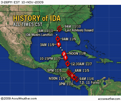
Was not saying the patterns are similar just the fact that there are similarities location wise, if this was a MDR "Ida" then of course it would be silly, just thought it was interesting, well on another note, good to see that in November 2009 we were on "9th" named storm, fast forward twelve years and its third week of August
0 likes
Once I see the REDS and GREENS Converge on a Base Velocity. ... I'm There!!
This is NOT an Official Forecast....Just my Opinion. For official information, please refer to the NHC and NWS products.
HIGHLIGHTS : '13 El Reno Tornado : 2013 Storm Chaser Tour, Joaquin; SC flood event, Matthew '16, Lowcountry Snow storm Jan '18
This is NOT an Official Forecast....Just my Opinion. For official information, please refer to the NHC and NWS products.
HIGHLIGHTS : '13 El Reno Tornado : 2013 Storm Chaser Tour, Joaquin; SC flood event, Matthew '16, Lowcountry Snow storm Jan '18
Re: ATL: INVEST 99L - Models
I'm not sure if this has been stated in previous pages, but a local met here in SETX believes the low is further north than what the NHC charted in the modeling. He did not expand on that, said he would post a full update later. Has anyone else heard this or does anyone know how that would affect a potential track?
0 likes
Re: ATL: INVEST 99L - Models
Senobia wrote:I'm not sure if this has been stated in previous pages, but a local met here in SETX believes the low is further north than what the NHC charted in the modeling. He did not expand on that, said he would post a full update later. Has anyone else heard this or does anyone know how that would affect a potential track?
That's likely the location that the GFS, Euro and others have been using for the center. If the low-level circ gets pulled into that, we're off to the races. No idea though if that MLC wins or not.
0 likes
Personal Forecast Disclaimer:
The posts in this forum are NOT official forecast and should not be used as such. They are just the opinion of the poster and may or may not be backed by sound meteorological data. They are NOT endorsed by any professional institution or storm2k.org. For official information, please refer to the NHC and NWS products.
The posts in this forum are NOT official forecast and should not be used as such. They are just the opinion of the poster and may or may not be backed by sound meteorological data. They are NOT endorsed by any professional institution or storm2k.org. For official information, please refer to the NHC and NWS products.
Re: ATL: INVEST 99L - Models
1 likes
Re: ATL: INVEST 99L - Models
SoupBone wrote:Senobia wrote:I'm not sure if this has been stated in previous pages, but a local met here in SETX believes the low is further north than what the NHC charted in the modeling. He did not expand on that, said he would post a full update later. Has anyone else heard this or does anyone know how that would affect a potential track?
That's likely the location that the GFS, Euro and others have been using for the center. If the low-level circ gets pulled into that, we're off to the races. No idea though if that MLC wins or not.
NHS is further down the wave axis. I never get hung up on a MLC. IMO
0 likes
-
Clearcloudz

- Category 2

- Posts: 540
- Joined: Sun Jun 10, 2018 1:46 pm
- Location: Rosenberg TX
Re: ATL: INVEST 99L - Models
12Z EPS Ensemble

12Z GEFS Ensemble

12Z Canadian GEM Ensemble

12Z GEFS Ensemble
12Z Canadian GEM Ensemble
Last edited by Clearcloudz on Wed Aug 25, 2021 4:25 pm, edited 1 time in total.
0 likes
Re: ATL: INVEST 99L - Models
ICON coming in maybe slightly north of its last run, but barely noticeable at 78 hours.
0 likes
Personal Forecast Disclaimer:
The posts in this forum are NOT official forecast and should not be used as such. They are just the opinion of the poster and may or may not be backed by sound meteorological data. They are NOT endorsed by any professional institution or storm2k.org. For official information, please refer to the NHC and NWS products.
The posts in this forum are NOT official forecast and should not be used as such. They are just the opinion of the poster and may or may not be backed by sound meteorological data. They are NOT endorsed by any professional institution or storm2k.org. For official information, please refer to the NHC and NWS products.
Who is online
Users browsing this forum: No registered users and 5 guests