https://twitter.com/SDBrownWX/status/1299529307161796608
If the forecasts are to verify, this map would become very difficult to discern with Ida covering Harvey and Laura.
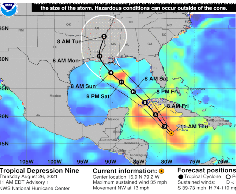
ATL: IDA - Remnants - Discussion
Moderator: S2k Moderators
-
Category5Kaiju

- Category 5

- Posts: 4336
- Joined: Thu Dec 24, 2020 12:45 pm
- Location: Seattle during the summer, Phoenix during the winter
Re: ATL: NINE - Tropical Depression - Discussion
0 likes
Unless explicitly stated, all information in my posts is based on my own opinions and observations. Tropical storms and hurricanes can be extremely dangerous. Refer to an accredited weather research agency or meteorologist if you need to make serious decisions regarding an approaching storm.
-
BensonTCwatcher

- Category 5
- Posts: 1050
- Joined: Sat Aug 28, 2004 10:11 pm
- Location: Southport NC
Re: ATL: NINE - Tropical Depression - Discussion
https://weather.cod.edu/satrad/?parms=subregional-W_Caribbean-truecolor-24-1-100-1&checked=map&colorbar=undefined
The Northern lobe has pretty well decided to close off and this looks like game on but earlier than the previous runs. Getting the recon in there will likely see strong consensus on track today/tonight but intensity could be tough to keep up with (Gulf storm in August High ocean heat content)
The Northern lobe has pretty well decided to close off and this looks like game on but earlier than the previous runs. Getting the recon in there will likely see strong consensus on track today/tonight but intensity could be tough to keep up with (Gulf storm in August High ocean heat content)
0 likes
-
ConvergenceZone
.gif)
- Category 5
- Posts: 5241
- Joined: Fri Jul 29, 2005 1:40 am
- Location: Northern California
Re: ATL: NINE - Tropical Depression - Discussion
Hmm, wonder when the Weather Channel will begin their 24 hour coverage? Not a big fan of the weather channel anymore, but they still have the best hurricane coverage/updates....I don't have comcast anymore which is why I subscribe to the streaming service Frndly during the summer(just to get the weather channel) and then cancel it after hurricane season is over 
3 likes

Re: ATL: NINE - Tropical Depression - Discussion
NDG wrote:X is where they estimate the CoC to be and initiated advisories. Close to the area I have been looking at this morning.
https://i.imgur.com/JDbn8ip.gif
With overall model support being pretty tight for this TD, I'd be pretty confident that NHC has a pretty good handle on track and motion. Having said that, it is this formative stage that often results in tweaked adjustments simply because there yet remains a definitive COC to initialize. While the LLC has been determined to be around 16.9 & 79.2, I get the sense that the LLC may still be a bit stretched north to south. If that might be the case, and given the orientation of convective activity and perhaps MLC slightly north of that point, I could see a "re-adjustment" or center relocation a bit more northward later in the day or this evening. If correct, recon will suggest the potentially broader wind-field and we might see the formative LLC slide a bit more north into and in better alignment with the MLC late today/tonight. If that occurred then I'd guess this would be reflected in this evening's 0Z model runs. Overall track prediction might therefore end up being nudged a little to the right POSSIBLY suggesting an increased landfall risk to the Mobile/Biloxi area.
1 likes
Andy D
(For official information, please refer to the NHC and NWS products.)
(For official information, please refer to the NHC and NWS products.)
-
capNstorms
- Tropical Storm

- Posts: 128
- Age: 33
- Joined: Mon Jun 14, 2021 12:48 pm
- Location: Beaumont, TX
Re: ATL: NINE - Tropical Depression - Discussion
SoupBone wrote:capNstorms wrote:as NINE approaches the GOM, I believe the high is dipping further south and way west forcing this into Texas just my .02c
There's no evidence of this right now so what makes you think this will occur?
using short range pressure pattern models and also observation and history. is this going to turn into a 2004/2005 type season? check the sat this morning look at the coast we have a telegram from mother nature.
https://imgur.com/MqClQ1p
1 likes
-
skyline385

- Category 5
- Posts: 2728
- Age: 35
- Joined: Wed Aug 26, 2020 11:15 pm
- Location: Houston TX
Re: ATL: NINE - Tropical Depression - Discussion
Stronger 12Z GFS with 951mb around NOLA close to landfall
1 likes
-
BensonTCwatcher
- Category 5
- Posts: 1050
- Joined: Sat Aug 28, 2004 10:11 pm
- Location: Southport NC
Re: ATL: NINE - Tropical Depression - Discussion
You can see the northern portion closing off here https://earth.nullschool.net/#current/wind/isobaric/1000hPa/orthographic=-79.19,18.54,2533/loc=-52.988,12.676
Also if your not familiar, click on the menu lower left and select the various height up through 500mb . It appears to be stacking up in earnest ( based on NCEP and GFS which this is derived from)
Also if your not familiar, click on the menu lower left and select the various height up through 500mb . It appears to be stacking up in earnest ( based on NCEP and GFS which this is derived from)
0 likes
-
BigB0882
- S2K Supporter

- Posts: 2292
- Joined: Thu Jul 03, 2003 12:08 am
- Location: Baton Rouge, LA
- Contact:
Re: ATL: NINE - Tropical Depression - Discussion
skyline385 wrote:Stronger 12Z GFS with 951mb around NOLA close to landfall
What direction is the heading? Sorry to ask but most sites are blocked where I work so most images do not show up for me.
0 likes
-
tolakram
- Admin

- Posts: 20186
- Age: 62
- Joined: Sun Aug 27, 2006 8:23 pm
- Location: Florence, KY (name is Mark)
Re: ATL: NINE - Tropical Depression - Discussion
BigB0882 wrote:skyline385 wrote:Stronger 12Z GFS with 951mb around NOLA close to landfall
What direction is the heading? Sorry to ask but most sites are blocked where I work so most images do not show up for me.
Can you see this, and work the controls at the top?
https://www.tropicaltidbits.com/analysis/models/?model=gfs®ion=seus&pkg=mslp_wind&runtime=2021082612&fh=0
0 likes
M a r k
- - - - -
Join us in chat: Storm2K Chatroom Invite. Android and IOS apps also available.
The posts in this forum are NOT official forecasts and should not be used as such. Posts are NOT endorsed by any professional institution or STORM2K.org. For official information and forecasts, please refer to NHC and NWS products.
-
cycloneye

- Admin
- Posts: 149520
- Age: 69
- Joined: Thu Oct 10, 2002 10:54 am
- Location: San Juan, Puerto Rico
Re: ATL: NINE - Tropical Depression - Discussion Update= Recon is delayed
0 likes
Visit the Caribbean-Central America Weather Thread where you can find at first post web cams,radars
and observations from Caribbean basin members Click Here
and observations from Caribbean basin members Click Here
-
AerospaceEng
- Tropical Depression

- Posts: 53
- Joined: Mon Mar 07, 2016 10:34 am
Re: ATL: NINE - Tropical Depression - Discussion Update= Recon is delayed
Yeah, that’s not a good look. Strong signal of a possible major hurricane into NOLA and recon can’t fly?
1 likes

Re: ATL: NINE - Tropical Depression - Discussion Update= Recon is delayed
Not to freak anyone out, but apparently Katrina also blew up over an extremely warm Loop Current.
https://en.m.wikipedia.org/wiki/Meteoro ... height.jpg
At least Ida will have less time between exiting land and going over the Loop Current than Katrina.
https://en.m.wikipedia.org/wiki/Meteoro ... height.jpg
At least Ida will have less time between exiting land and going over the Loop Current than Katrina.
Last edited by aspen on Thu Aug 26, 2021 11:06 am, edited 1 time in total.
8 likes
Irene '11 Sandy '12 Hermine '16 5/15/2018 Derecho Fay '20 Isaias '20 Elsa '21 Henri '21 Ida '21
I am only a meteorology enthusiast who knows a decent amount about tropical cyclones. Look to the professional mets, the NHC, or your local weather office for the best information.
I am only a meteorology enthusiast who knows a decent amount about tropical cyclones. Look to the professional mets, the NHC, or your local weather office for the best information.
Re: ATL: NINE - Tropical Depression - Discussion
chaser1 wrote:NDG wrote:X is where they estimate the CoC to be and initiated advisories. Close to the area I have been looking at this morning.
https://i.imgur.com/JDbn8ip.gif
With overall model support being pretty tight for this TD, I'd be pretty confident that NHC has a pretty good handle on track and motion. Having said that, it is this formative stage that often results in tweaked adjustments simply because there yet remains a definitive COC to initialize. While the LLC has been determined to be around 16.9 & 79.2, I get the sense that the LLC may still be a bit stretched north to south. If that might be the case, and given the orientation of convective activity and perhaps MLC slightly north of that point, I could see a "re-adjustment" or center relocation a bit more northward later in the day or this evening. If correct, recon will suggest the potentially broader wind-field and we might see the formative LLC slide a bit more north into and in better alignment with the MLC late today/tonight. If that occurred then I'd guess this would be reflected in this evening's 0Z model runs. Overall track prediction might therefore end up being nudged a little to the right POSSIBLY suggesting an increased landfall risk to the Mobile/Biloxi area.
With cooler heads prevailing....and after reading discussion number one on TD 9....I agree with you...the information available ATM from the NHC suggests vigilance is in order...points eastward from the current NHC forecast track.....and of course westward... to the Upper Texas coast...
Last edited by underthwx on Thu Aug 26, 2021 11:07 am, edited 1 time in total.
0 likes
-
Shell Mound
- Category 5
- Posts: 2432
- Age: 33
- Joined: Thu Sep 07, 2017 3:39 pm
- Location: St. Petersburg, FL → Scandinavia
Re: ATL: NINE - Tropical Depression - Discussion Update= Recon is delayed
https://twitter.com/DanLeonard_wx/status/1430912848406929410
https://twitter.com/DrKimWood/status/1430918910627352580
https://twitter.com/JackSillin/status/1430924933580918784
https://twitter.com/COweatherman/status/1430924891788693508
https://twitter.com/DrKimWood/status/1430918910627352580
https://twitter.com/JackSillin/status/1430924933580918784
https://twitter.com/COweatherman/status/1430924891788693508
Last edited by Shell Mound on Thu Aug 26, 2021 11:29 am, edited 2 times in total.
0 likes
CVW / MiamiensisWx / Shell Mound
The posts in this forum are NOT official forecasts and should not be used as such. They are just the opinion of the poster and may or may not be backed by sound meteorological data. They are NOT endorsed by any professional institution or STORM2K. For official information, please refer to products from the NHC and NWS.
-
BigB0882
- S2K Supporter
- Posts: 2292
- Joined: Thu Jul 03, 2003 12:08 am
- Location: Baton Rouge, LA
- Contact:
Re: ATL: NINE - Tropical Depression - Discussion
tolakram wrote:BigB0882 wrote:skyline385 wrote:Stronger 12Z GFS with 951mb around NOLA close to landfall
What direction is the heading? Sorry to ask but most sites are blocked where I work so most images do not show up for me.
Can you see this, and work the controls at the top?
https://www.tropicaltidbits.com/analysis/models/?model=gfs®ion=seus&pkg=mslp_wind&runtime=2021082612&fh=0
Thank you, that site is not blocked! Looks like this run of the GFS suggests that it wouldn't take much change in timing to end up hooking earlier and going into the MS/AL coast. That's one thing I will be watching closely for.
0 likes
-
SouthDadeFish

- Professional-Met

- Posts: 2835
- Joined: Thu Sep 23, 2010 2:54 pm
- Location: Miami, FL
- Contact:
-
UTSARoadrunner4
- Category 1

- Posts: 265
- Age: 29
- Joined: Wed Aug 26, 2020 11:19 pm
Re: ATL: NINE - Tropical Depression - Discussion
Isn’t the High supposed to weaken a little bit which would allow for soon-to-be Ida to go at a more NNW or NW direction to Louisiana rather than a WNW or W direction to Texas?
capNstorms wrote:SoupBone wrote:capNstorms wrote:as NINE approaches the GOM, I believe the high is dipping further south and way west forcing this into Texas just my .02c
There's no evidence of this right now so what makes you think this will occur?
using short range pressure pattern models and also observation and history. is this going to turn into a 2004/2005 type season? check the sat this morning look at the coast we have a telegram from mother nature.
https://imgur.com/MqClQ1p
2 likes

Re: ATL: NINE - Tropical Depression - Discussion
...quotes from model thread...but did not want to clutter the forum with non model discussion...
I get that and meant to put a disclaimer in my post addressing the issue. That said, a direct hit on New Orleans would be worse from the overall humanitarian perspective. Other places can take along the gulf coast can take a direct hit much better and with a limited risk of lost lives, however it is still devastating for those who lose their homes.
With the vulnerable population and potential of levees failing, the storm missing New Orleans is a better scenario. Ideally the best outcome(besides a weak storm) would be for it to hit in sparsely populated areas, but again it is still bad for those who get hit.
jlauderdal wrote:Not if you are east or west of NOJr0d wrote:Rgv20 wrote:6zGFS with a nightmare scenario of a land falling hurricane into New Orleans in a little over 3 days...Very little time for preparations.
GFS, CMC and EURO are showing New Orleans hits. Hopefully that changes.
I get that and meant to put a disclaimer in my post addressing the issue. That said, a direct hit on New Orleans would be worse from the overall humanitarian perspective. Other places can take along the gulf coast can take a direct hit much better and with a limited risk of lost lives, however it is still devastating for those who lose their homes.
With the vulnerable population and potential of levees failing, the storm missing New Orleans is a better scenario. Ideally the best outcome(besides a weak storm) would be for it to hit in sparsely populated areas, but again it is still bad for those who get hit.
0 likes
-
Hurrilurker

- Category 2

- Posts: 738
- Joined: Mon Jun 09, 2003 3:32 pm
- Location: San Francisco, CA
Re: ATL: NINE - Tropical Depression - Discussion Update= Recon is delayed
I hope people in the Caymans are paying attention and preparing. They're going to be in for a nasty surprise from a rapidly-strengthening storm.
0 likes
Re: ATL: NINE - Tropical Depression - Discussion Update= Recon is delayed
aspen wrote:Not to freak anyone out, but apparently Katrina also blew up over an extremely warm Loop Current.
https://en.m.wikipedia.org/wiki/Meteoro ... height.jpg
At least Ida will have less time between exiting land and going over the Loop Current than Katrina.
And unfortunately there waters are alot warmer near the coast then katrina went through, so where she weaken, think Ida might keep strengthing all the way to the coast, everyone be safe
1 likes
Who is online
Users browsing this forum: No registered users and 14 guests