ATL: IDA - Models

Moderator: S2k Moderators

Message
Author
sphelps8681
Category 2
Category 2
Posts: 785
Joined: Thu Aug 16, 2007 5:37 pm
Location: Somewhere over the rainbow

Re: ATL: IDA - Models

#801 Postby sphelps8681 » Thu Aug 26, 2021 6:44 pm

Blinhart wrote:I'm waiting to see the models tonight to move back West of Vermillion Bay but not to Calcasieu Pass. I think the models are still trying to zero in on the exact spot of where this is going until it does consolidate completely and decides if it will move through the channel or over Cuba.


What scenario besides the ridge will effect where this goes. What would bring it closer to Texas? Thanks.
0 likes   

Nederlander
S2K Supporter
S2K Supporter
Posts: 1248
Joined: Sat Jul 19, 2008 4:28 pm
Location: Conroe, TX

Re: ATL: IDA - Models

#802 Postby Nederlander » Thu Aug 26, 2021 6:48 pm

sphelps8681 wrote:
Blinhart wrote:I'm waiting to see the models tonight to move back West of Vermillion Bay but not to Calcasieu Pass. I think the models are still trying to zero in on the exact spot of where this is going until it does consolidate completely and decides if it will move through the channel or over Cuba.


What scenario besides the ridge will effect where this goes. What would bring it closer to Texas? Thanks.

Nothing… that is exactly the steering mechanism. Confidence is strong in the NHC track to LA within 3 days.
0 likes   

tolakram
Admin
Admin
Posts: 19990
Age: 61
Joined: Sun Aug 27, 2006 8:23 pm
Location: Florence, KY (name is Mark)

Re: ATL: IDA - Models

#803 Postby tolakram » Thu Aug 26, 2021 6:49 pm

18Z HWRF
Image
0 likes   
M a r k
- - - - -
Join us in chat: Storm2K Chatroom Invite. Android and IOS apps also available.

The posts in this forum are NOT official forecasts and should not be used as such. Posts are NOT endorsed by any professional institution or STORM2K.org. For official information and forecasts, please refer to NHC and NWS products.

PandaCitrus
Category 1
Category 1
Posts: 424
Joined: Mon Sep 04, 2017 2:44 pm

Re: ATL: IDA - Models

#804 Postby PandaCitrus » Thu Aug 26, 2021 7:00 pm

This would be a worse case scenario event for New Orleans, even worse landfall position than Katrina. Hopefully it landfalls where nobody but gators live further west.

Steve wrote:
IcyTundra wrote:18Z GFS Grand Isle, LA landfall 1 PM central time on Sunday.


Looks like the eye will pass right over the Westbank and City of New Orleans.
https://i.imgur.com/iPZ7ggk.png
1 likes   

underthwx
Category 5
Category 5
Posts: 2351
Joined: Sat Jul 30, 2011 2:14 pm
Location: Brazoria County Texas

Re: ATL: IDA - Models

#805 Postby underthwx » Thu Aug 26, 2021 7:03 pm

tolakram wrote:18Z HWRF
https://i.imgur.com/3ce0l2w.png


Is that image generated from recon data?...
0 likes   

tolakram
Admin
Admin
Posts: 19990
Age: 61
Joined: Sun Aug 27, 2006 8:23 pm
Location: Florence, KY (name is Mark)

Re: ATL: IDA - Models

#806 Postby tolakram » Thu Aug 26, 2021 7:05 pm

underthwx wrote:
tolakram wrote:18Z HWRF
https://i.imgur.com/3ce0l2w.png


Is that image generated from recon data?...


Doubt it, the run started right at the time recon reached the system.
0 likes   
M a r k
- - - - -
Join us in chat: Storm2K Chatroom Invite. Android and IOS apps also available.

The posts in this forum are NOT official forecasts and should not be used as such. Posts are NOT endorsed by any professional institution or STORM2K.org. For official information and forecasts, please refer to NHC and NWS products.

rw1984
S2K Supporter
S2K Supporter
Posts: 25
Joined: Fri Aug 17, 2012 5:28 pm

Re: ATL: IDA - Models

#807 Postby rw1984 » Thu Aug 26, 2021 7:29 pm

Will the 0z models this evening have the recon data incorporated?
0 likes   

sphelps8681
Category 2
Category 2
Posts: 785
Joined: Thu Aug 16, 2007 5:37 pm
Location: Somewhere over the rainbow

Re: ATL: IDA - Models

#808 Postby sphelps8681 » Thu Aug 26, 2021 7:30 pm

Nederlander wrote:
sphelps8681 wrote:
Blinhart wrote:I'm waiting to see the models tonight to move back West of Vermillion Bay but not to Calcasieu Pass. I think the models are still trying to zero in on the exact spot of where this is going until it does consolidate completely and decides if it will move through the channel or over Cuba.


What scenario besides the ridge will effect where this goes. What would bring it closer to Texas? Thanks.

Nothing… that is exactly the steering mechanism. Confidence is strong in the NHC track to LA within 3 days.


Not talking a direct hit but more on rain and wind.
0 likes   

User avatar
gatorcane
S2K Supporter
S2K Supporter
Posts: 23689
Age: 47
Joined: Sun Mar 13, 2005 3:54 pm
Location: Boca Raton, FL

Re: ATL: IDA - Models

#809 Postby gatorcane » Thu Aug 26, 2021 7:38 pm

GFS closeup simulated IR: :eek:

Image
1 likes   

User avatar
cycloneye
Admin
Admin
Posts: 143900
Age: 68
Joined: Thu Oct 10, 2002 10:54 am
Location: San Juan, Puerto Rico

Re: ATL: IDA - Models

#810 Postby cycloneye » Thu Aug 26, 2021 7:56 pm

00z Guidance.

Image

Image
1 likes   
Visit the Caribbean-Central America Weather Thread where you can find at first post web cams,radars
and observations from Caribbean basin members Click Here

User avatar
Blinhart
Category 5
Category 5
Posts: 2079
Age: 48
Joined: Thu Sep 08, 2011 3:13 pm
Location: Crowley, La.

Re: ATL: IDA - Models

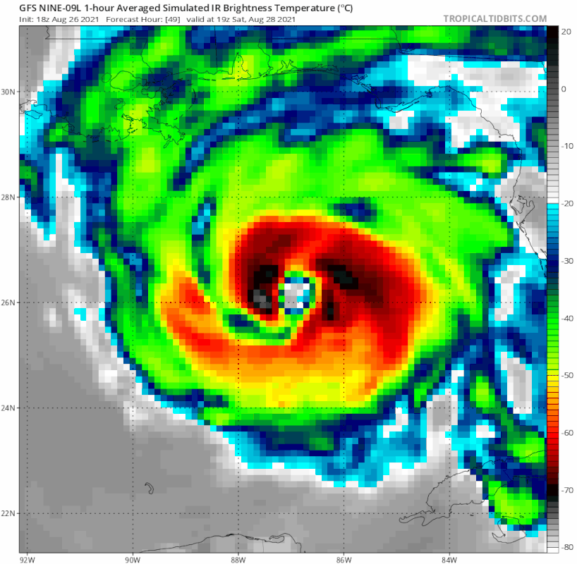
#811 Postby Blinhart » Thu Aug 26, 2021 8:07 pm

Nederlander wrote:
sphelps8681 wrote:
Blinhart wrote:I'm waiting to see the models tonight to move back West of Vermillion Bay but not to Calcasieu Pass. I think the models are still trying to zero in on the exact spot of where this is going until it does consolidate completely and decides if it will move through the channel or over Cuba.


What scenario besides the ridge will effect where this goes. What would bring it closer to Texas? Thanks.

Nothing… that is exactly the steering mechanism. Confidence is strong in the NHC track to LA within 3 days.


I never said it was going to Texas. I said it would move further West from Morgan City to just West of Intracoastal City.
1 likes   
Personal Forecast Disclaimer:
The posts in this forum are NOT official forecast and should not be used as such. They are just the opinion of the poster and may or may not be backed by sound meteorological data. They are NOT endorsed by any professional institution or storm2k.org. For official information, please refer to the NHC and NWS products.

User avatar
PTrackerLA
Category 5
Category 5
Posts: 5276
Age: 41
Joined: Thu Oct 10, 2002 8:40 pm
Location: Lafayette, LA

Re: ATL: IDA - Models

#812 Postby PTrackerLA » Thu Aug 26, 2021 8:33 pm


NHC now east of TVCN, west shift at 10pm upcoming?
0 likes   

User avatar
PTrackerLA
Category 5
Category 5
Posts: 5276
Age: 41
Joined: Thu Oct 10, 2002 8:40 pm
Location: Lafayette, LA

Re: ATL: IDA - Models

#813 Postby PTrackerLA » Thu Aug 26, 2021 8:39 pm

18z Euro ensembles

1 likes   

Sciencerocks
Category 5
Category 5
Posts: 8905
Age: 39
Joined: Thu Jul 06, 2017 1:51 am

Re: ATL: IDA - Models

#814 Postby Sciencerocks » Thu Aug 26, 2021 8:55 pm

cycloneye wrote:00z Guidance.


https://i.imgur.com/iLSVVJJ.png


My thinking is for this to be more like a low to mid end cat2 by landfall. I wouldn't be shocked if it got stronger but chances are it won't be a cat4 or 5.
3 likes   

sphelps8681
Category 2
Category 2
Posts: 785
Joined: Thu Aug 16, 2007 5:37 pm
Location: Somewhere over the rainbow

Re: ATL: IDA - Models

#815 Postby sphelps8681 » Thu Aug 26, 2021 9:21 pm

PTrackerLA wrote:18z Euro ensembles

https://imgur.com/FMTixnL


Looks like models spreading out a bit. Curious how this works out. Extreme E Tx is still in the cone from what I can see.
0 likes   

CrazyC83
Professional-Met
Professional-Met
Posts: 34001
Joined: Tue Mar 07, 2006 11:57 pm
Location: Deep South, for the first time!

Re: ATL: IDA - Models

#816 Postby CrazyC83 » Thu Aug 26, 2021 9:22 pm

PTrackerLA wrote:


NHC now east of TVCN, west shift at 10pm upcoming?


Honestly, I wouldn't make the shift yet. Let's see if it holds up longer before moving the track.
1 likes   

User avatar
Blinhart
Category 5
Category 5
Posts: 2079
Age: 48
Joined: Thu Sep 08, 2011 3:13 pm
Location: Crowley, La.

Re: ATL: IDA - Models

#817 Postby Blinhart » Thu Aug 26, 2021 9:38 pm

Shouldn't new models be rolling right now?
0 likes   
Personal Forecast Disclaimer:
The posts in this forum are NOT official forecast and should not be used as such. They are just the opinion of the poster and may or may not be backed by sound meteorological data. They are NOT endorsed by any professional institution or storm2k.org. For official information, please refer to the NHC and NWS products.

Keldeo1997
Category 2
Category 2
Posts: 637
Joined: Fri Oct 11, 2019 11:35 pm

Re: ATL: IDA - Models

#818 Postby Keldeo1997 » Thu Aug 26, 2021 9:43 pm

2 likes   

User avatar
Steve
S2K Supporter
S2K Supporter
Posts: 9591
Joined: Sat Apr 05, 2003 11:41 pm
Location: Not a state-caster

Re: ATL: IDA - Models

#819 Postby Steve » Thu Aug 26, 2021 9:57 pm

Sciencerocks wrote:
cycloneye wrote:00z Guidance.


https://i.imgur.com/iLSVVJJ.png


My thinking is for this to be more like a low to mid end cat2 by landfall. I wouldn't be shocked if it got stronger but chances are it won't be a cat4 or 5.


Yeah, I think 4 or 5 are unlikely as well if not impossible. Earlier I guessed 70% at Cat 3. Not sure I'm that high anymore - probably more like 40-45%. But since they sample so much stuff now, they may be able to find at least an extended gust into Cat 3 territory over the Gulf. Glad to see an extreme slowdown is probably off the table too. I'm a wuss and not really ready to make a call like I have for the last 25 years on here or CFHC. But I feel like it will landfall between Slidell and Marsh Island with the zoomed in range of Cocodrie to Centerville/Patterson (just west of Morgan City).
1 likes   

jaguars_22
Category 2
Category 2
Posts: 571
Joined: Tue Jun 20, 2017 2:26 pm

Re: ATL: IDA - Models

#820 Postby jaguars_22 » Thu Aug 26, 2021 10:01 pm

Nam shows pressure at 896… omg if that ever happens :)
1 likes   


Return to “2021”

Who is online

Users browsing this forum: No registered users and 38 guests