https://twitter.com/NWSNewOrleans/status/1431786337770905601
ATL: IDA - Remnants - Discussion
Moderator: S2k Moderators
-
tolakram
- Admin

- Posts: 20186
- Age: 62
- Joined: Sun Aug 27, 2006 8:23 pm
- Location: Florence, KY (name is Mark)
Re: ATL: IDA - Hurricane - Discussion
5 likes
M a r k
- - - - -
Join us in chat: Storm2K Chatroom Invite. Android and IOS apps also available.
The posts in this forum are NOT official forecasts and should not be used as such. Posts are NOT endorsed by any professional institution or STORM2K.org. For official information and forecasts, please refer to NHC and NWS products.
-
Hypercane_Kyle

- Category 5

- Posts: 3465
- Joined: Sat Mar 07, 2015 7:58 pm
- Location: Cape Canaveral, FL
Re: ATL: IDA - Hurricane - Discussion
Dropsonde has 113 knots not too far above the surface. Although these are probably gusts, it is indicative that Ida is a solid (and strengthening) Category 2 hurricane.
Last edited by Hypercane_Kyle on Sat Aug 28, 2021 8:13 pm, edited 1 time in total.
7 likes
My posts are my own personal opinion, defer to the National Hurricane Center (NHC) and other NOAA products for decision making during hurricane season.

Re: ATL: IDA - Hurricane - Discussion
Hypercane_Kyle wrote:Highteeld wrote:StormPyrate wrote:I thought they had reported eye closed earlier
Last VDM came through said "open to the south"
Incorrect.Code: Select all
D. Minimum Sea Level Pressure: 967mb (28.56 inHg)
E. Dropsonde Surface Wind at Center: From 130° at 10kts (From the SE at 12mph)
F. Eye Character: Closed
G. Eye Shape & Diameter: Circular with a diameter of 20 nautical miles (23 statute miles)
no, the one previous to that. i should have clarified that
1 likes
Very useful information on the Dvorak Technique --
https://severe.worldweather.wmo.int/TCF ... kBeven.pdf
https://severe.worldweather.wmo.int/TCF ... kBeven.pdf
-
tolakram
- Admin
- Posts: 20186
- Age: 62
- Joined: Sun Aug 27, 2006 8:23 pm
- Location: Florence, KY (name is Mark)
Re: ATL: IDA - Hurricane - Discussion

1 likes
M a r k
- - - - -
Join us in chat: Storm2K Chatroom Invite. Android and IOS apps also available.
The posts in this forum are NOT official forecasts and should not be used as such. Posts are NOT endorsed by any professional institution or STORM2K.org. For official information and forecasts, please refer to NHC and NWS products.
- - - - -
Join us in chat: Storm2K Chatroom Invite. Android and IOS apps also available.
The posts in this forum are NOT official forecasts and should not be used as such. Posts are NOT endorsed by any professional institution or STORM2K.org. For official information and forecasts, please refer to NHC and NWS products.
-
Smurfwicked
- Tropical Storm

- Posts: 164
- Age: 41
- Joined: Mon Sep 03, 2007 7:47 pm
- Location: SETX
Re: ATL: IDA - Hurricane - Discussion
grapealcoholic wrote:Wind field starting to symmetrize
http://tropic.ssec.wisc.edu/real-time/adt/09L-2DWIND.GIF
I'm new to this graphic. I'm assuming the numbers in the bottom left are the distance in miles from center? Also red is peak or max winds? Green is hurricane+ winds? Blue TS+ winds?
1 likes
-
catskillfire51
- S2K Supporter

- Posts: 480
- Age: 39
- Joined: Sun Aug 26, 2012 5:40 pm
- Location: Lake Jackson, TX
Re: ATL: IDA - Hurricane - Discussion
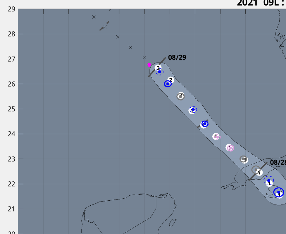
tolakram wrote:https://i.imgur.com/27hnUPX.png
Does the track seem like it missed the eye or is that just a plotting error?
0 likes
-
Hypercane_Kyle
- Category 5
- Posts: 3465
- Joined: Sat Mar 07, 2015 7:58 pm
- Location: Cape Canaveral, FL
Re: ATL: IDA - Hurricane - Discussion
Highteeld wrote:Hypercane_Kyle wrote:Highteeld wrote:Last VDM came through said "open to the south"
Incorrect.Code: Select all
D. Minimum Sea Level Pressure: 967mb (28.56 inHg)
E. Dropsonde Surface Wind at Center: From 130° at 10kts (From the SE at 12mph)
F. Eye Character: Closed
G. Eye Shape & Diameter: Circular with a diameter of 20 nautical miles (23 statute miles)
no, the one previous to that. i should have clarified that
I understand. Sorry for the mixup.
2 likes
My posts are my own personal opinion, defer to the National Hurricane Center (NHC) and other NOAA products for decision making during hurricane season.
Re: ATL: IDA - Hurricane - Discussion
Red is hurricane, green is "50 kts" which is the severe thunderstorm threshold (think, takes down trees) and blue is TS force winds.Smurfwicked wrote:grapealcoholic wrote:Wind field starting to symmetrize
http://tropic.ssec.wisc.edu/real-time/adt/09L-2DWIND.GIF
I'm new to this graphic. I'm assuming the numbers in the bottom left are the distance in miles from center? Also red is peak or max winds? Green is hurricane+ winds? Blue TS+ winds?
4 likes

Re: ATL: IDA - Hurricane - Discussion
RAP forecast at landfall tomorrow afternoon.
No convective inhibition but moving into drier mid-level air.
Not too sure this will be intensifying at landfall.
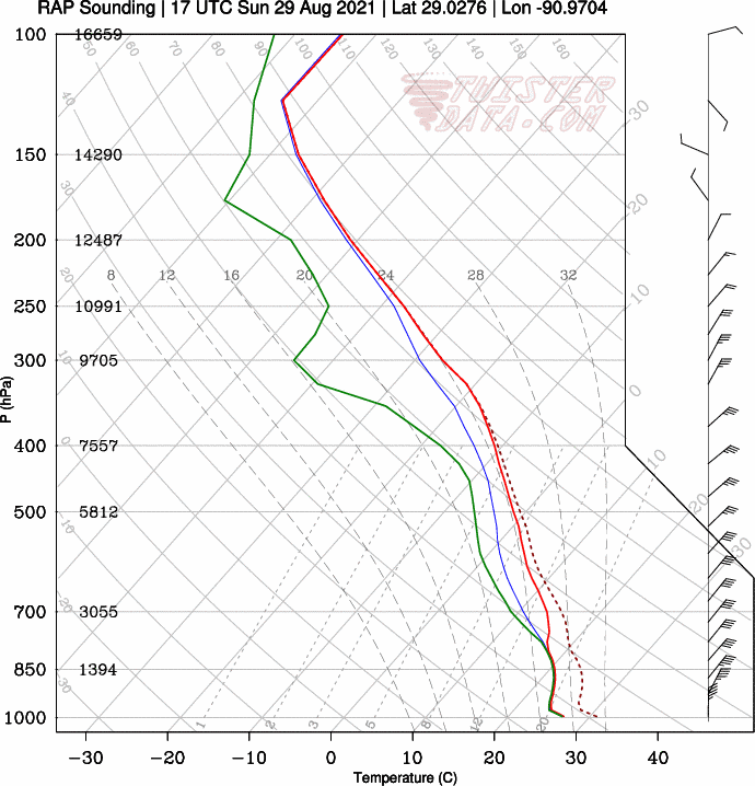
No convective inhibition but moving into drier mid-level air.
Not too sure this will be intensifying at landfall.
5 likes
-
cheezyWXguy

- Category 5
- Posts: 6282
- Joined: Mon Feb 13, 2006 12:29 am
- Location: Dallas, TX
Re: ATL: IDA - Hurricane - Discussion
Really coming together on IR now. Still on track to cat4 in my opinion.
0 likes
-
SEASON_CANCELED

- Category 3

- Posts: 887
- Joined: Mon Jul 06, 2009 5:17 am
- Location: 8 Bit Charlie Sheen
Re: ATL: IDA - Hurricane - Discussion
cheezyWXguy wrote:Really coming together on IR now. Still on track to cat4 in my opinion.
Agreed. Ill even forecast a Cat- 5 . My personal forecast....the waters support it.
We will wake to a nightmare
Just my opinion! Listen to your local Political Critters and the NHC for guidance and as always, see below
The posts in this forum are NOT official forecasts and should not be used as such. They are just the opinion of the poster and may or may not be backed by sound meteorological data. They are NOT endorsed by any professional institution or STORM2K. For official information, please refer to products from the NHC and NWS.
Last edited by SEASON_CANCELED on Sat Aug 28, 2021 8:21 pm, edited 1 time in total.
1 likes
i am a big stupid ugly moron with an ugly face and a big butt and my butt stinks and i like to kiss my own butt
Re: ATL: IDA - Hurricane - Discussion
Really digging that hot tower in the northern eyewall
0 likes
Very useful information on the Dvorak Technique --
https://severe.worldweather.wmo.int/TCF ... kBeven.pdf
https://severe.worldweather.wmo.int/TCF ... kBeven.pdf
-
tropicwatch

- Category 5
- Posts: 3426
- Age: 62
- Joined: Sat Jun 02, 2007 10:01 am
- Location: The Villages, Florida
- Contact:
Re: ATL: IDA - Hurricane - Discussion
Kermit ascending probably headed home. Next Flight AF take off a little after 1am central time.
1 likes
Tropicwatch
Agnes 72', Eloise 75, Elena 85', Kate 85', Charley 86', Florence 88', Beryl 94', Dean 95', Erin 95', Opal 95', Earl 98', Georges 98', Ivan 2004', Arlene 2005', Dennis 2005', Ida 2009' Debby 2012' Irma 2017' Michael 2018'
Agnes 72', Eloise 75, Elena 85', Kate 85', Charley 86', Florence 88', Beryl 94', Dean 95', Erin 95', Opal 95', Earl 98', Georges 98', Ivan 2004', Arlene 2005', Dennis 2005', Ida 2009' Debby 2012' Irma 2017' Michael 2018'
-
SEASON_CANCELED
- Category 3
- Posts: 887
- Joined: Mon Jul 06, 2009 5:17 am
- Location: 8 Bit Charlie Sheen
Re: ATL: IDA - Hurricane - Discussion
Also noteworthy that high tide will be in 10 hours
We dont have that going for us. thats an extra 2 feet
We dont have that going for us. thats an extra 2 feet
1 likes
i am a big stupid ugly moron with an ugly face and a big butt and my butt stinks and i like to kiss my own butt
Re: ATL: IDA - Hurricane - Discussion
Stupid Godfather reference is stupid

3 likes
Very useful information on the Dvorak Technique --
https://severe.worldweather.wmo.int/TCF ... kBeven.pdf
https://severe.worldweather.wmo.int/TCF ... kBeven.pdf

Re: ATL: IDA - Hurricane - Discussion
My guess for Ida’s intensity when I wake up at like 6 tomorrow morning: 954-958mb and 95-100 kt.
3 likes
Irene '11 Sandy '12 Hermine '16 5/15/2018 Derecho Fay '20 Isaias '20 Elsa '21 Henri '21 Ida '21
I am only a meteorology enthusiast who knows a decent amount about tropical cyclones. Look to the professional mets, the NHC, or your local weather office for the best information.
I am only a meteorology enthusiast who knows a decent amount about tropical cyclones. Look to the professional mets, the NHC, or your local weather office for the best information.
-
catskillfire51
- S2K Supporter
- Posts: 480
- Age: 39
- Joined: Sun Aug 26, 2012 5:40 pm
- Location: Lake Jackson, TX
Re: ATL: IDA - Hurricane - Discussion
GCANE wrote:Latest fix is just slightly south of track
[url]https://i.postimg.cc/HxzRpLhp/99L1.png [/url]
I asked Tolakram but it looks the track was south of the eye, do you think that could be a reason why or is it just a plotting error on the chart?
0 likes
-
Nate-Gillson
- Tropical Storm
- Posts: 133
- Age: 40
- Joined: Sun Aug 22, 2004 8:27 pm
- Location: Cedar Rapids, Iowa
Re: ATL: IDA - Hurricane - Discussion
panamatropicwatch wrote:Kermit ascending probably headed home. Next Flight AF take off a little after 1am central time.
Hopefully they won't have any troubles this time unless it's a different plane. Anticipating waking up to a borderline cat 3 unless Ida pulls a fast one.
0 likes
-
SunnyThoughts
- Category 5
- Posts: 2263
- Joined: Wed Jul 09, 2003 12:42 pm
- Location: Pensacola, Florida
Re: ATL: IDA - Hurricane - Discussion
Nate-Gillson wrote:panamatropicwatch wrote:Kermit ascending probably headed home. Next Flight AF take off a little after 1am central time.
Hopefully they won't have any troubles this time unless it's a different plane. Anticipating waking up to a borderline cat 3.
So will be 6 hours before we get another plane inside the storm. With a powerful hurricane gaining strength, this close to the coast. Just wonderful.
2 likes
Who is online
Users browsing this forum: No registered users and 35 guests