ATL: IDA - Remnants - Discussion
Moderator: S2k Moderators
-
cheezyWXguy

- Category 5

- Posts: 6282
- Joined: Mon Feb 13, 2006 12:29 am
- Location: Dallas, TX
Re: ATL: IDA - Hurricane - Discussion
A lot of comments made about 10 hours ago have now aged like milk.
22 likes

Re: ATL: IDA - Hurricane - Discussion
I've been watching Ida for most of today and at some point I will admit I believed she was falling behind schedule in intensity and that maybe she wouldn't reach C4 as forecast. Foolish I know. Mentally eating the biggest of crows at the moment.
Never doubt our top-notch forecasters. Awful situation evolving before our eyes.
Never doubt our top-notch forecasters. Awful situation evolving before our eyes.
Last edited by Landy on Sun Aug 29, 2021 1:42 am, edited 1 time in total.
7 likes
-
Yellow Evan

- Professional-Met

- Posts: 16240
- Age: 27
- Joined: Fri Jul 15, 2011 12:48 pm
- Location: Henderson, Nevada/Honolulu, HI
- Contact:
Re: ATL: IDA - Hurricane - Discussion
TXNT25 KNES 290632
TCSNTL
A. 09L (IDA)
B. 29/0531Z
C. 27.5N
D. 88.7W
E. ONE/GOES-E
F. T5.5/5.5
G. IR/EIR/SWIR
H. REMARKS...AN EYE EMBEDDED WITHIN LG RESULTS IN AN ENO OF 5.0. FOR AN
EYE THAT IS OW AND SURROUNDED BY B, THE EADJ IS +0.5, RESULTING IN A DT
OF 5.5. THE MET IS 6.0 BASED ON A RAPIDLY DEVELOPING TREND IN APPARENT
INTENSITY OVER THE PAST 24 HOURS. THE PT IS ALSO 6.0. THE FT IS BASED
ON THE DT.
I. ADDL POSITIONS
NIL
...HOSLEY
SAB what.
Last edited by Yellow Evan on Sun Aug 29, 2021 1:42 am, edited 1 time in total.
0 likes
-
SEASON_CANCELED

- Category 3

- Posts: 887
- Joined: Mon Jul 06, 2009 5:17 am
- Location: 8 Bit Charlie Sheen
Re: ATL: IDA - Hurricane - Discussion
cheezyWXguy wrote:A lot of comments made about 10 hours ago have now aged like milk.
As they do around here..forecasts are a dime a dozen and usually wrong
Last edited by SEASON_CANCELED on Sun Aug 29, 2021 1:42 am, edited 1 time in total.
0 likes
i am a big stupid ugly moron with an ugly face and a big butt and my butt stinks and i like to kiss my own butt

Re: ATL: IDA - Hurricane - Discussion
Each new frame the storm looks increasingly violent
2 likes
Very useful information on the Dvorak Technique --
https://severe.worldweather.wmo.int/TCF ... kBeven.pdf
https://severe.worldweather.wmo.int/TCF ... kBeven.pdf
-
PavelGaborik
- Tropical Depression

- Posts: 81
- Joined: Thu Oct 06, 2016 11:13 pm
Re: ATL: IDA - Hurricane - Discussion
cheezyWXguy wrote:A lot of comments made about 10 hours ago have now aged like milk.
I wouldn't say so. Just 5-6 hours ago Ida was trending significantly lower then where she was forecast to be intensity wise.
Things can change rapidly in the tropics.
0 likes
-
UTSARoadrunner4
- Category 1

- Posts: 265
- Age: 29
- Joined: Wed Aug 26, 2020 11:19 pm
Re: ATL: IDA - Hurricane - Discussion
I forgot who said it, but someone said not to turn your back on Ida. What’s going on tonight is beyond astounding… 
4 likes


Re: ATL: IDA - Hurricane - Discussion
Highteeld wrote:Each new frame the storm looks increasingly violent
.....And, awfully close to land!
1 likes
Re: ATL: IDA - Hurricane - Discussion
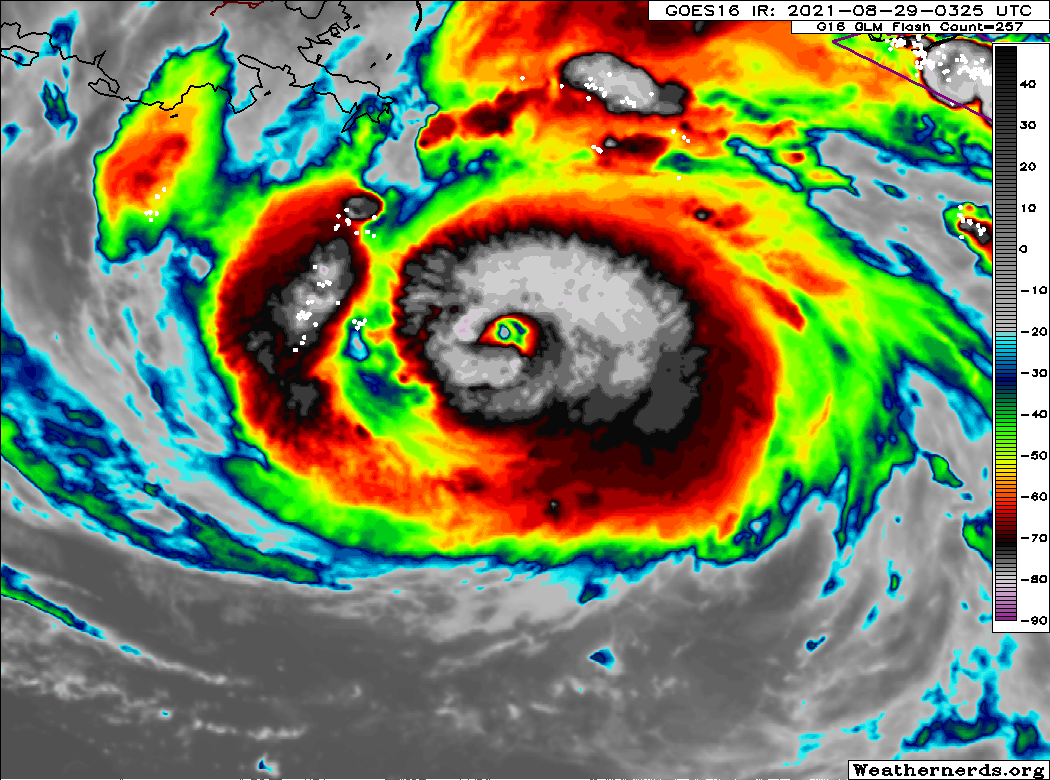
Impressive subsidence signature in the eye dropsonde.

0 likes
Very useful information on the Dvorak Technique --
https://severe.worldweather.wmo.int/TCF ... kBeven.pdf
https://severe.worldweather.wmo.int/TCF ... kBeven.pdf
-
USTropics
- Professional-Met
- Posts: 2738
- Joined: Sun Aug 12, 2007 3:45 am
- Location: Florida State University
Re: ATL: IDA - Hurricane - Discussion
Explosive lightning now occurring within the eyewall, expect multiple hot towers to start forming with the significant updrafts developing (for the science behind lightning in tropical systems, see my post here):
11 likes
Re: ATL: IDA - Hurricane - Discussion
PavelGaborik wrote:cheezyWXguy wrote:A lot of comments made about 10 hours ago have now aged like milk.
I wouldn't say so. Just 5-6 hours ago Ida was trending significantly lower then where she was forecast to be intensity wise.
Things can change rapidly in the tropics.
All the people saying this wouldn’t be a Cat 4 and would just barely make a major. Those definitely didn’t age well.
6 likes
-
cheezyWXguy
- Category 5
- Posts: 6282
- Joined: Mon Feb 13, 2006 12:29 am
- Location: Dallas, TX
Re: ATL: IDA - Hurricane - Discussion
PavelGaborik wrote:cheezyWXguy wrote:A lot of comments made about 10 hours ago have now aged like milk.
I wouldn't say so. Just 5-6 hours ago Ida was trending significantly lower then where she was forecast to be intensity wise.
Things can change rapidly in the tropics.
You don’t think that comments suggesting a peak as a low cat3 or comparisons to gustav are inaccurate at this point?
5 likes
-
PavelGaborik
- Tropical Depression
- Posts: 81
- Joined: Thu Oct 06, 2016 11:13 pm
Re: ATL: IDA - Hurricane - Discussion
KimmieLa wrote:Highteeld wrote:Each new frame the storm looks increasingly violent
.....And, awfully close to land!
Unfortunately not close enough. She will still have a solid 12+ hours over water.
2 likes
-
ElectricStorm

- Category 5
- Posts: 5147
- Age: 25
- Joined: Tue Aug 13, 2019 11:23 pm
- Location: Norman, OK
Re: ATL: IDA - Hurricane - Discussion
Drop supports 950 so not as low as extrap
0 likes
B.S Meteorology, University of Oklahoma '25
Please refer to the NHC, NWS, or SPC for official information.
Please refer to the NHC, NWS, or SPC for official information.

Re: ATL: IDA - Hurricane - Discussion
cheezyWXguy wrote:A lot of comments made about 10 hours ago have now aged like milk.
I miss the good ole days.
1 likes
Baton Rouge area cyclone dilettante, PSWAGGER* tropical weather & hydrology model developer
(* Pseudo-Scientific Wild-A** Guesses Generally Expressed Ridiculously)
The GFDL would've had all this figured out by now.
(* Pseudo-Scientific Wild-A** Guesses Generally Expressed Ridiculously)
The GFDL would've had all this figured out by now.
Re: ATL: IDA - Hurricane - Discussion
Hurricane Ida Tropical Cyclone Update
NWS National Hurricane Center Miami FL AL092021
200 AM CDT Sun Aug 29 2021
...MAJOR HURRICANE IDA CONTINUES TO STRENGTHEN...
...NOW A DANGEROUS CATEGORY 4 HURRICANE...
Data from an Air Force Reserve Hurricane Hunter aircraft and NOAA
Doppler weather radars indicate that Hurricane Ida has continued to
rapidly intensify this Sunday morning. Maximum sustained winds are
now estimated to be 130 mph (215 km/h). This makes Ida a category 4
hurricane on the Saffir-Simpson Hurricane Wind Scale.
Ida's central pressure has fallen 6 millibars during the past hour.
4 likes
Personal Forecast Disclaimer:
The posts in this forum are NOT official forecast and should not be used as such. They are just the opinion of the poster and may or may not be backed by sound meteorological data. They are NOT endorsed by any professional institution or storm2k.org. For official information, please refer to the NHC and NWS products.
The posts in this forum are NOT official forecast and should not be used as such. They are just the opinion of the poster and may or may not be backed by sound meteorological data. They are NOT endorsed by any professional institution or storm2k.org. For official information, please refer to the NHC and NWS products.
-
Texashawk

- Category 2

- Posts: 579
- Joined: Tue Aug 14, 2007 1:50 am
- Location: Missouri City, TX (Houston)
Re: ATL: IDA - Hurricane - Discussion
I see Stacy Stewart is manning the desk this morning. That kind of raises an eyebrow.
4 likes
-
Hurricane Mike
- Category 2
- Posts: 675
- Joined: Tue Apr 10, 2018 7:44 am
Re: ATL: IDA - Hurricane - Discussion
This convection bubbling around the eye reminds me of Michael.
0 likes
-
Hypercane_Kyle

- Category 5
- Posts: 3465
- Joined: Sat Mar 07, 2015 7:58 pm
- Location: Cape Canaveral, FL
Re: ATL: IDA - Hurricane - Discussion
Still plenty of time to intensify further.
My guess: 155-160mph landfall.
My guess: 155-160mph landfall.
0 likes
My posts are my own personal opinion, defer to the National Hurricane Center (NHC) and other NOAA products for decision making during hurricane season.
Who is online
Users browsing this forum: No registered users and 45 guests