2021 Global Model Runs Discussion (Out thru day 16)
Moderator: S2k Moderators
Forum rules

The posts in this forum are NOT official forecasts and should not be used as such. They are just the opinion of the poster and may or may not be backed by sound meteorological data. They are NOT endorsed by any professional institution or STORM2K. For official information, please refer to products from the National Hurricane Center and National Weather Service.

Re: 2021 Global Model Runs Discussion (Out thru day 16)
There is a tropical wave that’ll emerge off of Africa on Sunday or early Monday. While no operational model develops it, some ensemble members do, and we should probably keep an eye on it as the MJO enters Phase 4. The GFS is stuck showing a sinking branch over Africa so it won’t show anything in the Atlantic within the next 10-12 days (besides Larry) until that error is corrected.
0 likes
Irene '11 Sandy '12 Hermine '16 5/15/2018 Derecho Fay '20 Isaias '20 Elsa '21 Henri '21 Ida '21
I am only a meteorology enthusiast who knows a decent amount about tropical cyclones. Look to the professional mets, the NHC, or your local weather office for the best information.
I am only a meteorology enthusiast who knows a decent amount about tropical cyclones. Look to the professional mets, the NHC, or your local weather office for the best information.
-
SFLcane

- S2K Supporter

- Posts: 10281
- Age: 48
- Joined: Sat Jun 05, 2010 1:44 pm
- Location: Lake Worth Florida
Re: 2021 Global Model Runs Discussion (Out thru day 16)
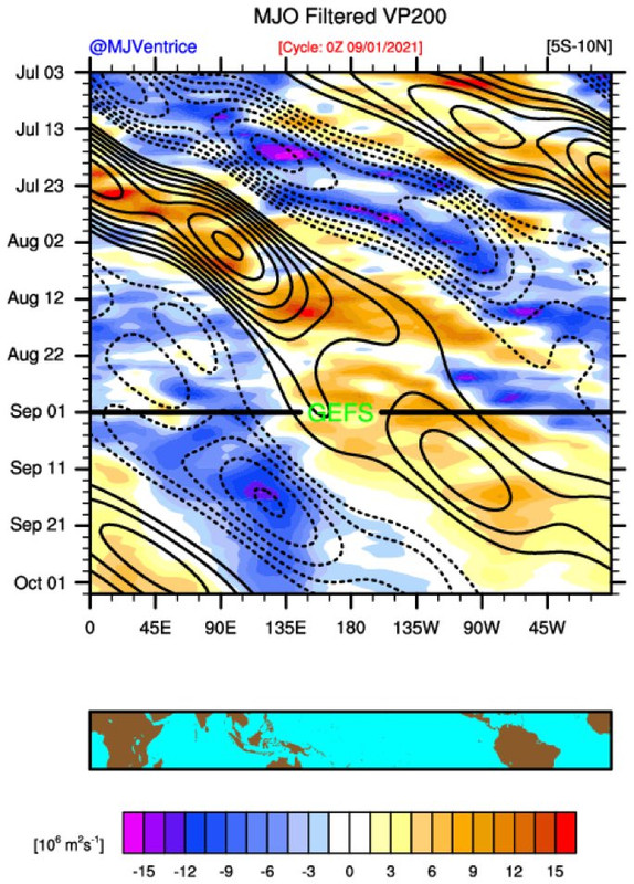
Suppressed state is coming the MJO isn't weak EOF based RMMS might suggest that. This is a blend between GFS/statistical.
1 likes
-
AlphaToOmega
- Category 5

- Posts: 1448
- Joined: Sat Jun 26, 2021 10:51 am
- Location: Somewhere in Massachusetts
Re: 2021 Global Model Runs Discussion (Out thru day 16)
SFLcane wrote:Suppressed state is coming the MJO isn't weak EOF based RMMS might suggest that. This is a blend between GFS/statistical.
https://i.postimg.cc/TwSbTWdx/1-ACEC7-A8-4439-420-C-8-BE6-31-F796-A88033.jpg
I would not give it too much weight. The GFS has always wanted to kill the WAM.
0 likes
-
SFLcane
- S2K Supporter
- Posts: 10281
- Age: 48
- Joined: Sat Jun 05, 2010 1:44 pm
- Location: Lake Worth Florida
Re: 2021 Global Model Runs Discussion (Out thru day 16)
AlphaToOmega wrote:SFLcane wrote:Suppressed state is coming the MJO isn't weak EOF based RMMS might suggest that. This is a blend between GFS/statistical.
https://i.postimg.cc/TwSbTWdx/1-ACEC7-A8-4439-420-C-8-BE6-31-F796-A88033.jpg
I would not give it too much weight. The GFS has always wanted to kill the WAM.
I think the reason not much is developing right behind Larry is the big PV streamer its outflow pinches off. Some differences between GEFS and EPS on how favorable the Atlantic will be.
0 likes
-
Hypercane_Kyle

- Category 5
- Posts: 3465
- Joined: Sat Mar 07, 2015 7:58 pm
- Location: Cape Canaveral, FL
Re: 2021 Global Model Runs Discussion (Out thru day 16)
Some ensemble support for a west-gulf storm ~D5-D9.
0 likes
My posts are my own personal opinion, defer to the National Hurricane Center (NHC) and other NOAA products for decision making during hurricane season.

Re: 2021 Global Model Runs Discussion (Out thru day 16)
Teban54 wrote:Steve wrote:MJO looks to be making a run for 4/5 which would coincide with the discussion from a week ago as to whether or not we might have a week to 10 days break in early September. Doesn’t mean there can’t be any activity. But we aren’t likely to see a burst of 4 or 5 systems right away. Caution is the unfiltered output does show phase 3 until next weekend. Storms are firing in the Indian Ocean so it’s not going to be 100% quiet.
Does Phase 4 mean enhanced or reduced activity? Another post in the indicators thread said Phase 4 would be active, and IIRC some pro mets on Twitter mentioned
Phase 4 has the highest track density in the Atlantic.
No. IV has some landfalls and areas in the Atlantic. 5/6/7 can get sparse. But it’s early September not July. So that matters too
Last edited by Steve on Wed Sep 01, 2021 8:47 pm, edited 1 time in total.
0 likes
-
SFLcane
- S2K Supporter
- Posts: 10281
- Age: 48
- Joined: Sat Jun 05, 2010 1:44 pm
- Location: Lake Worth Florida
Re: 2021 Global Model Runs Discussion (Out thru day 16)
You know what’s been the one of the most amazing things so far this season is not seeing the gfs nail SFL with a major hurricane at longer ranges. Hopefully this is not a bad thing.

6 likes
-
AutoPenalti
- Category 5
- Posts: 4091
- Age: 29
- Joined: Mon Aug 17, 2015 4:16 pm
- Location: Ft. Lauderdale, Florida
Re: 2021 Global Model Runs Discussion (Out thru day 16)
SFLcane wrote:You know what’s been the one of the most amazing things so far this season is not seeing the gfs nail SFL with a major hurricane at longer ranges. Hopefully this is not a bad thing.
I think the only one that did was the HWRF.
1 likes
The posts in this forum are NOT official forecasts and should not be used as such. They are just the opinion of the poster and may or may not be backed by sound meteorological data. They are NOT endorsed by any professional institution or STORM2K. For official information, please refer to products from the NHC and NWS.
Model Runs Cheat Sheet:
GFS (5:30 AM/PM, 11:30 AM/PM)
HWRF, GFDL, UKMET, NAVGEM (6:30-8:00 AM/PM, 12:30-2:00 AM/PM)
ECMWF (1:45 AM/PM)
TCVN is a weighted averaged
-
SFLcane
- S2K Supporter
- Posts: 10281
- Age: 48
- Joined: Sat Jun 05, 2010 1:44 pm
- Location: Lake Worth Florida
Re: 2021 Global Model Runs Discussion (Out thru day 16)
This is the brightest I have seen Florida all season. Even some Caribbean action. 
Id like to see that on the GEFS
Id like to see that on the GEFS
3 likes
-
Category5Kaiju

- Category 5
- Posts: 4336
- Joined: Thu Dec 24, 2020 12:45 pm
- Location: Seattle during the summer, Phoenix during the winter
Re: 2021 Global Model Runs Discussion (Out thru day 16)
SFLcane wrote:This is the brightest I have seen Florida all season. Even some Caribbean action.
Id like to see that on the GEFS
https://i.postimg.cc/k5N2vrc0/750743-E5-2533-4731-AC46-889-EAA228-E1-F.gif
The Carolinas: sad noises
1 likes
Unless explicitly stated, all information in my posts is based on my own opinions and observations. Tropical storms and hurricanes can be extremely dangerous. Refer to an accredited weather research agency or meteorologist if you need to make serious decisions regarding an approaching storm.
-
AutoPenalti
- Category 5
- Posts: 4091
- Age: 29
- Joined: Mon Aug 17, 2015 4:16 pm
- Location: Ft. Lauderdale, Florida
Re: 2021 Global Model Runs Discussion (Out thru day 16)
SFLcane wrote:This is the brightest I have seen Florida all season. Even some Caribbean action.
Id like to see that on the GEFS
https://i.postimg.cc/k5N2vrc0/750743-E5-2533-4731-AC46-889-EAA228-E1-F.gif
Carolinas punching the air right now.
0 likes
The posts in this forum are NOT official forecasts and should not be used as such. They are just the opinion of the poster and may or may not be backed by sound meteorological data. They are NOT endorsed by any professional institution or STORM2K. For official information, please refer to products from the NHC and NWS.
Model Runs Cheat Sheet:
GFS (5:30 AM/PM, 11:30 AM/PM)
HWRF, GFDL, UKMET, NAVGEM (6:30-8:00 AM/PM, 12:30-2:00 AM/PM)
ECMWF (1:45 AM/PM)
TCVN is a weighted averaged
-
lsuhurricane
- Category 1

- Posts: 270
- Joined: Tue Aug 15, 2017 2:53 pm
Re: 2021 Global Model Runs Discussion (Out thru day 16)
A bit concerned about NW GOM mid-next week development after reviewing the 12z CMC model solution.
The 18z GFS now develops a closed low at this same time frame which provides a bit of continuity. Unfortunately, their ensembles are also supporting this area as well.
The 18z GFS now develops a closed low at this same time frame which provides a bit of continuity. Unfortunately, their ensembles are also supporting this area as well.
0 likes
Re: 2021 Global Model Runs Discussion (Out thru day 16)
lsuhurricane wrote:A bit concerned about NW GOM mid-next week development after reviewing the 12z CMC model solution.
The 18z GFS now develops a closed low at this same time frame which provides a bit of continuity. Unfortunately, their ensembles are also supporting this area as well.
Something to keep an eye on for sure. The western gulf is untapped and plently warm to support tropical development.
0 likes
-
johngaltfla

- Category 5
- Posts: 2073
- Joined: Sun Jul 10, 2005 9:17 pm
- Location: Sarasota County, FL
- Contact:
Re: 2021 Global Model Runs Discussion (Out thru day 16)
lsuhurricane wrote:A bit concerned about NW GOM mid-next week development after reviewing the 12z CMC model solution.
The 18z GFS now develops a closed low at this same time frame which provides a bit of continuity. Unfortunately, their ensembles are also supporting this area as well.
Tis the season so buckle up. We're in for a fascinating ride in September.
0 likes
-
toad strangler

- S2K Supporter
- Posts: 4546
- Joined: Sun Jul 28, 2013 3:09 pm
- Location: Earth
- Contact:
Re: 2021 Global Model Runs Discussion (Out thru day 16)
johngaltfla wrote:lsuhurricane wrote:A bit concerned about NW GOM mid-next week development after reviewing the 12z CMC model solution.
The 18z GFS now develops a closed low at this same time frame which provides a bit of continuity. Unfortunately, their ensembles are also supporting this area as well.
Tis the season so buckle up. We're in for a fascinating ride in September.
And most likely October.
0 likes
My Weather Station
https://www.wunderground.com/dashboard/pws/KFLPORTS603
https://www.wunderground.com/dashboard/pws/KFLPORTS603
-
Category5Kaiju
- Category 5
- Posts: 4336
- Joined: Thu Dec 24, 2020 12:45 pm
- Location: Seattle during the summer, Phoenix during the winter
Re: 2021 Global Model Runs Discussion (Out thru day 16)
From the possible Gulf system to the wave behind Larry, I am not sure if calling for an inactive September is going to pan out well as model support does exist for both possible AOIs. September imho is far from dead.
0 likes
Unless explicitly stated, all information in my posts is based on my own opinions and observations. Tropical storms and hurricanes can be extremely dangerous. Refer to an accredited weather research agency or meteorologist if you need to make serious decisions regarding an approaching storm.
-
cajungal

- Category 5
- Posts: 2354
- Age: 49
- Joined: Sun Mar 14, 2004 9:34 pm
- Location: Schriever, Louisiana (60 miles southwest of New Orleans)
Re: 2021 Global Model Runs Discussion (Out thru day 16)
Well my area is in complete ruins from Ida. If another one comes then I am moving out of Louisiana and not looking back. Our roof needs to be replaced and ceiling leaking so praying for no more
4 likes
-
gatorcane

- S2K Supporter
- Posts: 23708
- Age: 48
- Joined: Sun Mar 13, 2005 3:54 pm
- Location: Boca Raton, FL
Re: 2021 Global Model Runs Discussion (Out thru day 16)
I know the graphic is stretched over Africa but look at that wave 
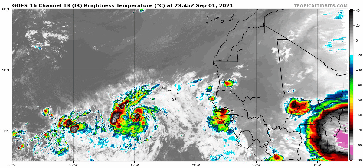
The wave emerges off the coast on Saturday and the GFS tries to develop it as it approaches the Lesser Antilles. Given the time of year, bears watching:
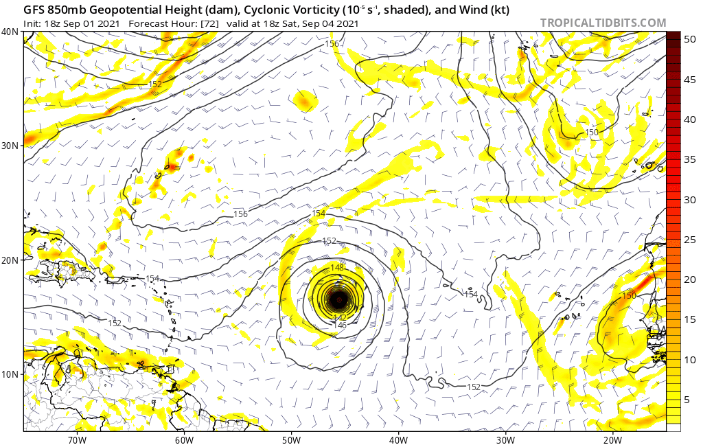
The wave emerges off the coast on Saturday and the GFS tries to develop it as it approaches the Lesser Antilles. Given the time of year, bears watching:
4 likes

Re: 2021 Global Model Runs Discussion (Out thru day 16)
gatorcane wrote:I know the graphic is stretched over Africa but look at that wave
https://i.postimg.cc/Gpxb1vgw/goes16-ir-eatl.gif
The wave emerges off the coast on Saturday and the GFS tries to develop it as it approaches the Lesser Antilles. Given the time of year, bears watching:
https://i.postimg.cc/jdc9KZth/gfs-z850-vort-eatl-fh72-252.gif
That is quite a thunderstorm over West Africa.
0 likes
Re: 2021 Global Model Runs Discussion (Out thru day 16)
gatorcane wrote:I know the graphic is stretched over Africa but look at that wave
https://i.postimg.cc/Gpxb1vgw/goes16-ir-eatl.gif
The wave emerges off the coast on Saturday and the GFS tries to develop it as it approaches the Lesser Antilles. Given the time of year, bears watching:
https://i.postimg.cc/jdc9KZth/gfs-z850-vort-eatl-fh72-252.gif
I think the GFS actually develops that next wave that comes off of Africa north of Puerto Rico and Hispanola. I could be wrong but that is what it looks like to me.

0 likes
Who is online
Users browsing this forum: tolakram and 114 guests