I suppose after the streak of 3 years in a row with 7+ named storms in September, people may be a bit spoiled. Not every year has such a large burst of activity in September, including active seasons (e.g. 2012, 2016). It also seems years with active Augusts tend to have not as many storms in September, such as 2012 (the counterexample being 2004). Also remember that 2017 *only* had 4 named storms form in September, and we all know how explosive that month was per hurricanes/majors/ACE.
Right now, the models might not be showing much ... maybe they turn out right or maybe once again they fail to detect imminent genesis ... but we shall wait and see.
p.s. Beware of October & November in a La Nina year like this.
2021 Indicators: SST's / SAL / MSLP / Shear / Steering / Instability / Sat Images
Moderator: S2k Moderators
Forum rules

The posts in this forum are NOT official forecasts and should not be used as such. They are just the opinion of the poster and may or may not be backed by sound meteorological data. They are NOT endorsed by any professional institution or STORM2K. For official information, please refer to products from the National Hurricane Center and National Weather Service.
-
Monsoonjr99
- Tropical Storm

- Posts: 210
- Age: 26
- Joined: Fri Sep 21, 2018 11:22 pm
- Location: Inland Empire, SoCal
Re: 2021 Indicators: SST's / SAL / MSLP / Shear / Steering / Instability / Sat Images
4 likes
The posts in this forum are NOT official forecasts and should not be used as such. They are just the opinion of the poster and may or may not be backed by sound meteorological data. They are NOT endorsed by any professional institution or STORM2K. For official information, please refer to products from the NHC and NWS.
Some Californian who codes things and tracks weather.
Kay '22, Hilary '23
-
AlphaToOmega
- Category 5

- Posts: 1448
- Joined: Sat Jun 26, 2021 10:51 am
- Location: Somewhere in Massachusetts
Re: 2021 Indicators: SST's / SAL / MSLP / Shear / Steering / Instability / Sat Images
Monsoonjr99 wrote:I suppose after the streak of 3 years in a row with 7+ named storms in September, people may be a bit spoiled. Not every year has such a large burst of activity in September, including active seasons (e.g. 2012, 2016). It also seems years with active Augusts tend to have not as many storms in September, such as 2012 (the counterexample being 2004). Also remember that 2017 *only* had 4 named storms form in September, and we all know how explosive that month was per hurricanes/majors/ACE.
Right now, the models might not be showing much ... maybe they turn out right or maybe once again they fail to detect imminent genesis ... but we shall wait and see.
p.s. Beware of October & November in a La Nina year like this.
Models are starting to become more bullish with development. Look in the models thread
EDIT: I think I figured out why models were initially bearish with development: dry air in the Atlantic. Once the SAL is gone, expect crazy development
1 likes
-
SFLcane

- S2K Supporter

- Posts: 10281
- Age: 48
- Joined: Sat Jun 05, 2010 1:44 pm
- Location: Lake Worth Florida
Re: 2021 Indicators: SST's / SAL / MSLP / Shear / Steering / Instability / Sat Images
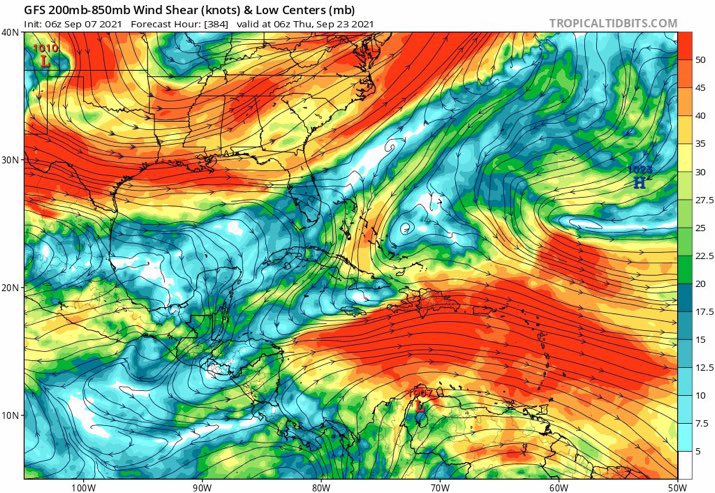
That’s 50kt windshear blowing through the Caribbean. Guess it's showing Pacific forcing
0 likes
-
AutoPenalti
- Category 5
- Posts: 4091
- Age: 29
- Joined: Mon Aug 17, 2015 4:16 pm
- Location: Ft. Lauderdale, Florida
Re: 2021 Indicators: SST's / SAL / MSLP / Shear / Steering / Instability / Sat Images
SFLcane wrote:That’s 50kt windshear blowing through the Caribbean. Guess it's showing Pacific forcing
https://i.postimg.cc/vBp4DZRR/55-B9-BF43-293-C-439-E-B1-FB-A48-FB2-B2-A7-B2.jpg
Are you serious GFS wtf...
2 likes
The posts in this forum are NOT official forecasts and should not be used as such. They are just the opinion of the poster and may or may not be backed by sound meteorological data. They are NOT endorsed by any professional institution or STORM2K. For official information, please refer to products from the NHC and NWS.
Model Runs Cheat Sheet:
GFS (5:30 AM/PM, 11:30 AM/PM)
HWRF, GFDL, UKMET, NAVGEM (6:30-8:00 AM/PM, 12:30-2:00 AM/PM)
ECMWF (1:45 AM/PM)
TCVN is a weighted averaged
-
toad strangler

- S2K Supporter
- Posts: 4546
- Joined: Sun Jul 28, 2013 3:09 pm
- Location: Earth
- Contact:
Re: 2021 Indicators: SST's / SAL / MSLP / Shear / Steering / Instability / Sat Images
SFLcane wrote:That’s 50kt windshear blowing through the Caribbean. Guess it's showing Pacific forcing
https://i.postimg.cc/vBp4DZRR/55-B9-BF43-293-C-439-E-B1-FB-A48-FB2-B2-A7-B2.jpg
384 hour shear maps
6 likes
My Weather Station
https://www.wunderground.com/dashboard/pws/KFLPORTS603
https://www.wunderground.com/dashboard/pws/KFLPORTS603
-
tolakram
- Admin

- Posts: 20186
- Age: 62
- Joined: Sun Aug 27, 2006 8:23 pm
- Location: Florence, KY (name is Mark)
Re: 2021 Indicators: SST's / SAL / MSLP / Shear / Steering / Instability / Sat Images
SFLcane wrote:That’s 50kt windshear blowing through the Caribbean. Guess it's showing Pacific forcing
https://i.postimg.cc/vBp4DZRR/55-B9-BF43-293-C-439-E-B1-FB-A48-FB2-B2-A7-B2.jpg
384 hour shear forecast from the GFS?
4 likes
M a r k
- - - - -
Join us in chat: Storm2K Chatroom Invite. Android and IOS apps also available.
The posts in this forum are NOT official forecasts and should not be used as such. Posts are NOT endorsed by any professional institution or STORM2K.org. For official information and forecasts, please refer to NHC and NWS products.
-
SFLcane
- S2K Supporter
- Posts: 10281
- Age: 48
- Joined: Sat Jun 05, 2010 1:44 pm
- Location: Lake Worth Florida
Re: 2021 Indicators: SST's / SAL / MSLP / Shear / Steering / Instability / Sat Images
Euro not as hostile but surely shows protective TUTT east of Florida.
0 likes
-
Category5Kaiju

- Category 5
- Posts: 4336
- Joined: Thu Dec 24, 2020 12:45 pm
- Location: Seattle during the summer, Phoenix during the winter
Re: 2021 Indicators: SST's / SAL / MSLP / Shear / Steering / Instability / Sat Images
SFLcane wrote:That’s 50kt windshear blowing through the Caribbean. Guess it's showing Pacific forcing
https://i.postimg.cc/vBp4DZRR/55-B9-BF43-293-C-439-E-B1-FB-A48-FB2-B2-A7-B2.jpg
Will the GFS ever realize that we are not entering a warm ENSO phase, let alone an El Niño? That shear pattern is what you would see in El Niño years, not La Nina. Oh yeah and plus it’s 384 hours out, so I’m honestly not going to take it seriously now.
3 likes
Unless explicitly stated, all information in my posts is based on my own opinions and observations. Tropical storms and hurricanes can be extremely dangerous. Refer to an accredited weather research agency or meteorologist if you need to make serious decisions regarding an approaching storm.
-
Category5Kaiju
- Category 5
- Posts: 4336
- Joined: Thu Dec 24, 2020 12:45 pm
- Location: Seattle during the summer, Phoenix during the winter
Re: 2021 Indicators: SST's / SAL / MSLP / Shear / Steering / Instability / Sat Images
SFLcane wrote:That’s 50kt windshear blowing through the Caribbean. Guess it's showing Pacific forcing
https://i.postimg.cc/vBp4DZRR/55-B9-BF43-293-C-439-E-B1-FB-A48-FB2-B2-A7-B2.jpg
Also, based on that model run for the GFS, it shows no discernible TCs during that timeframe in the EPAC (in fact, Olaf is the only one that forms), so I am honestly unsure if that shear is due to Pacific forcing. Honestly speaking given this to be the case, I am actually unsure where the GFS even thinks that kind of shear could possibly originate.
2 likes
Unless explicitly stated, all information in my posts is based on my own opinions and observations. Tropical storms and hurricanes can be extremely dangerous. Refer to an accredited weather research agency or meteorologist if you need to make serious decisions regarding an approaching storm.

Re: 2021 Indicators: SST's / SAL / MSLP / Shear / Steering / Instability / Sat Images
Category5Kaiju wrote:SFLcane wrote:That’s 50kt windshear blowing through the Caribbean. Guess it's showing Pacific forcing
https://i.postimg.cc/vBp4DZRR/55-B9-BF43-293-C-439-E-B1-FB-A48-FB2-B2-A7-B2.jpg
Will the GFS ever realize that we are not entering a warm ENSO phase, let alone an El Niño? That shear pattern is what you would see in El Niño years, not La Nina. Oh yeah and plus it’s 384 hours out, so I’m honestly not going to take it seriously now.
Yeah, making a shear map 24 hours in advance is already difficult enough, 384 hours is usually just an interesting model fantasy. That being said, this GFS output is truly weird.
0 likes

Re: 2021 Indicators: SST's / SAL / MSLP / Shear / Steering / Instability / Sat Images
Hopefully one of those upcoming waves becomes a long-tracking OTS major that doesn’t attempt ten billion EWRCs like Larry. It probably would’ve been a ~40 ACE Cat 4 if it wasn’t constantly growing larger and limiting itself as a result. Larry will probably max out at 27-30 ACE — quite a lot, but it could’ve been more. Another Larry-like storm will be enough on its own to get 2021 to the 1981-2010 average total season ACE.
0 likes
Irene '11 Sandy '12 Hermine '16 5/15/2018 Derecho Fay '20 Isaias '20 Elsa '21 Henri '21 Ida '21
I am only a meteorology enthusiast who knows a decent amount about tropical cyclones. Look to the professional mets, the NHC, or your local weather office for the best information.
I am only a meteorology enthusiast who knows a decent amount about tropical cyclones. Look to the professional mets, the NHC, or your local weather office for the best information.
-
Iceresistance

- Category 5
- Posts: 9592
- Age: 22
- Joined: Sat Oct 10, 2020 9:45 am
- Location: Tecumseh, OK/Norman, OK
Re: 2021 Indicators: SST's / SAL / MSLP / Shear / Steering / Instability / Sat Images
SFLcane wrote:That’s 50kt windshear blowing through the Caribbean. Guess it's showing Pacific forcing
https://i.postimg.cc/vBp4DZRR/55-B9-BF43-293-C-439-E-B1-FB-A48-FB2-B2-A7-B2.jpg
I'm thinking that the GFS wants to end Hurricane Season already . . .
0 likes
Bill 2015 & Beta 2020
Winter 2020-2021
All observations are in Tecumseh, OK unless otherwise noted.
Winter posts are focused mainly for Oklahoma & Texas.
Take any of my forecasts with a grain of salt, refer to the NWS, SPC, and NHC for official information
Never say Never with weather! Because ANYTHING is possible!
Winter 2020-2021
All observations are in Tecumseh, OK unless otherwise noted.
Winter posts are focused mainly for Oklahoma & Texas.
Take any of my forecasts with a grain of salt, refer to the NWS, SPC, and NHC for official information
Never say Never with weather! Because ANYTHING is possible!
-
SFLcane
- S2K Supporter
- Posts: 10281
- Age: 48
- Joined: Sat Jun 05, 2010 1:44 pm
- Location: Lake Worth Florida
Re: 2021 Indicators: SST's / SAL / MSLP / Shear / Steering / Instability / Sat Images
Interesting how once again this year the climatological peak of the season is not when the worst U.S. impacts are happening.
0 likes
Re: 2021 Indicators: SST's / SAL / MSLP / Shear / Steering / Instability / Sat Images
Climo Peak Day 2021 might be the most lackluster since 2019, with only Larry being active; I doubt 91L will develop. 2017 had Irma and Jose; 2018 had the trio of Florence, Helene, and Isaac; 2019 only had a dissipating Gabrielle; and 2020 had Paulette and Rene. However, the winner for the most lackluster Climo Peak Day is 2016, with ZERO active storms except for the invest that would become Ian.
2016 would suddenly become extremely active with Matthew and Nicole in October, 2017 would go on to produce two more long-duration majors in September (Lee and Maria), 2018 was in the middle of an active phase, 2019 would pick up steam a few days later, and 2020 was a few days into its bonkers mid-September TC spam. 2021 might be like 2016 and 2019 (and to a lesser extent 2020), where peak season day is before the actual peak of the specific season.
2016 would suddenly become extremely active with Matthew and Nicole in October, 2017 would go on to produce two more long-duration majors in September (Lee and Maria), 2018 was in the middle of an active phase, 2019 would pick up steam a few days later, and 2020 was a few days into its bonkers mid-September TC spam. 2021 might be like 2016 and 2019 (and to a lesser extent 2020), where peak season day is before the actual peak of the specific season.
8 likes
Irene '11 Sandy '12 Hermine '16 5/15/2018 Derecho Fay '20 Isaias '20 Elsa '21 Henri '21 Ida '21
I am only a meteorology enthusiast who knows a decent amount about tropical cyclones. Look to the professional mets, the NHC, or your local weather office for the best information.
I am only a meteorology enthusiast who knows a decent amount about tropical cyclones. Look to the professional mets, the NHC, or your local weather office for the best information.
-
Category5Kaiju
- Category 5
- Posts: 4336
- Joined: Thu Dec 24, 2020 12:45 pm
- Location: Seattle during the summer, Phoenix during the winter
Re: 2021 Indicators: SST's / SAL / MSLP / Shear / Steering / Instability / Sat Images
aspen wrote:Climo Peak Day 2021 might be the most lackluster since 2019, with only Larry being active; I doubt 91L will develop. 2017 had Irma and Jose; 2018 had the trio of Florence, Helene, and Isaac; 2019 only had a dissipating Gabrielle; and 2020 had Paulette and Rene. However, the winner for the most lackluster Climo Peak Day is 2016, with ZERO active storms except for the invest that would become Ian.
2016 would suddenly become extremely active with Matthew and Nicole in October, 2017 would go on to produce two more long-duration majors in September (Lee and Maria), 2018 was in the middle of an active phase, 2019 would pick up steam a few days later, and 2020 was a few days into its bonkers mid-September TC spam. 2021 might be like 2016 and 2019 (and to a lesser extent 2020), where peak season day is before the actual peak of the specific season.
Actually, I wouldn’t count out 91L just yet as it is still projected to go over the Gulf Stream, and the NHC notes it can still form then. As for seeing a lackluster peak season, I also think that with models showing some possibility of MDR activity later this month, perhaps you are onto something with the September 10 date being earlier than the real peak of this season? Either way, with how this season has been performing so far, I expect it to come into action again sometime this month.
0 likes
Unless explicitly stated, all information in my posts is based on my own opinions and observations. Tropical storms and hurricanes can be extremely dangerous. Refer to an accredited weather research agency or meteorologist if you need to make serious decisions regarding an approaching storm.
Re: 2021 Indicators: SST's / SAL / MSLP / Shear / Steering / Instability / Sat Images
Just wait I am sure we are in for a busy last week of September and all of October. Just because we are in supressed MJO phase right now doesn't mean it will be for the rest of the season. I expect the trend in recent seasons of having an active October to continue.
0 likes
-
Spacecoast

- Category 2

- Posts: 773
- Joined: Thu Aug 31, 2017 2:03 pm
Re: 2021 Indicators: SST's / SAL / MSLP / Shear / Steering / Instability / Sat Images
AlphaToOmega wrote:EDIT: I think I figured out why models were initially bearish with development: dry air in the Atlantic. Once the SAL is gone, expect crazy development
Current:

+3 Days:

Edit: +8 Days (

Last edited by Spacecoast on Tue Sep 07, 2021 8:46 pm, edited 1 time in total.
0 likes
-
AlphaToOmega
- Category 5
- Posts: 1448
- Joined: Sat Jun 26, 2021 10:51 am
- Location: Somewhere in Massachusetts
Re: 2021 Indicators: SST's / SAL / MSLP / Shear / Steering / Instability / Sat Images
aspen wrote:Climo Peak Day 2021 might be the most lackluster since 2019, with only Larry being active; I doubt 91L will develop. 2017 had Irma and Jose; 2018 had the trio of Florence, Helene, and Isaac; 2019 only had a dissipating Gabrielle; and 2020 had Paulette and Rene. However, the winner for the most lackluster Climo Peak Day is 2016, with ZERO active storms except for the invest that would become Ian.
2016 would suddenly become extremely active with Matthew and Nicole in October, 2017 would go on to produce two more long-duration majors in September (Lee and Maria), 2018 was in the middle of an active phase, 2019 would pick up steam a few days later, and 2020 was a few days into its bonkers mid-September TC spam. 2021 might be like 2016 and 2019 (and to a lesser extent 2020), where peak season day is before the actual peak of the specific season.
91L, the wave coming off Africa on September 10-11, and another low in the Caribbean Sea have some potential. September 10 is only an average, but the month of September is almost always the peak of hurricane season.
0 likes
-
AlphaToOmega
- Category 5
- Posts: 1448
- Joined: Sat Jun 26, 2021 10:51 am
- Location: Somewhere in Massachusetts
Re: 2021 Indicators: SST's / SAL / MSLP / Shear / Steering / Instability / Sat Images
Spacecoast wrote:AlphaToOmega wrote:EDIT: I think I figured out why models were initially bearish with development: dry air in the Atlantic. Once the SAL is gone, expect crazy development
Current:
[url]https://i.ibb.co/BgZywBT/ecmd.jpg [/url]
+3 Days:
[url]https://i.ibb.co/bHNwhQ2/ecmc.jpg [/url]
+14 Days
[url]https://i.ibb.co/XxDGJT9/ecmb.jpg [/url]
Something strange is going on
Saharan dust outbreaks are typically non-existent during September
0 likes
Re: 2021 Indicators: SST's / SAL / MSLP / Shear / Steering / Instability / Sat Images
Can't remember which season it was but it was either 2010 or 2011 where large Saharan dust outbreaks persisted into the month of September.
0 likes
Who is online
Users browsing this forum: No registered users and 161 guests