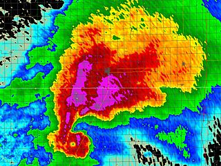
#544 Postby Kohlecane » Mon Sep 13, 2021 7:00 am
tolakram wrote:MBryant wrote:I'm having a difficult time with orientation between graphics. One looks like a center of circulation almost on top of Brownsville and the other is much further away and mostly eastward. Much of this is due to time and scale differences. Some is due to what appear to be multiple vortices, none of which have become dominant.
My bet guess is the COC on radar is in the extreme NW of the broader area of CCW flow.
But like I said initially, I could be confused.
As 57 said, the center we see on radar is doing a counter clockwise loop around a broader circulation. Because movement has slowed it looks confusing, but it appears the center is now moving east / ne or reforming further northeast. The further it gets away from the radar site the higher the altitude, which adds to the mess.
This is very interesting, that's quite the leap. Can we conclude this is why the models were very bouncy these past 2-3 runs specifically
2 likes
Once I see the REDS and GREENS Converge on a Base Velocity. ... I'm There!!
This is NOT an Official Forecast....Just my Opinion. For official information, please refer to the NHC and NWS products.
HIGHLIGHTS : '13 El Reno Tornado : 2013 Storm Chaser Tour, Joaquin; SC flood event, Matthew '16, Lowcountry Snow storm Jan '18


