ATL: SAM - Remnants - Discussion
Moderator: S2k Moderators
-
grapealcoholic
- Category 2

- Posts: 703
- Joined: Tue Aug 10, 2021 3:26 pm
-
Sciencerocks
- Category 5

- Posts: 10186
- Age: 40
- Joined: Thu Jul 06, 2017 1:51 am

-
Hypercane_Kyle

- Category 5
- Posts: 3465
- Joined: Sat Mar 07, 2015 7:58 pm
- Location: Cape Canaveral, FL
Re: ATL: SAM - Hurricane - Discussion
Zonacane wrote:grapealcoholic wrote:Statmospheric wrote:Current intensity makes a lot of sense. Don't see a lot of cat 5s (or near cat 5s) that don't have (nearly) perfectly symmetrical eyes. Albeit I do understand some of the current appearance is due to mesovortecies.
Also extremely rare for a storm to get back to Cat 5 after it initially peaks
Ivan: Am I a joke to you?
Irma, Isabel, Lorenzo...
1 likes
My posts are my own personal opinion, defer to the National Hurricane Center (NHC) and other NOAA products for decision making during hurricane season.

Re: ATL: SAM - Hurricane - Discussion
I take my eyes off the satellite loops for a few hours and come back to a dramatically improved eye presentation.
8 likes
The above post is not official and should not be used as such. It is the opinion of the poster and may or may not be backed by sound meteorological data. It is not endorsed by any professional institution or storm2k.org. For official information, please refer to the NHC and NWS products.


-
grapealcoholic
- Category 2
- Posts: 703
- Joined: Tue Aug 10, 2021 3:26 pm
Re: ATL: SAM - Hurricane - Discussion
Eye has been contracting. Should allow for some deeper convection to fire
0 likes
Re: ATL: SAM - Hurricane - Discussion
Recon very close.
0 likes
Personal Forecast Disclaimer:
The posts in this forum are NOT official forecast and should not be used as such. They are just the opinion of the poster and may or may not be backed by sound meteorological data. For official information, please refer to the NHC and NWS products.
The posts in this forum are NOT official forecast and should not be used as such. They are just the opinion of the poster and may or may not be backed by sound meteorological data. For official information, please refer to the NHC and NWS products.
-
Sciencerocks
- Category 5
- Posts: 10186
- Age: 40
- Joined: Thu Jul 06, 2017 1:51 am

-
grapealcoholic
- Category 2
- Posts: 703
- Joined: Tue Aug 10, 2021 3:26 pm
-
ElectricStorm

- Category 5
- Posts: 5147
- Age: 25
- Joined: Tue Aug 13, 2019 11:23 pm
- Location: Norman, OK
Re: ATL: SAM - Hurricane - Discussion
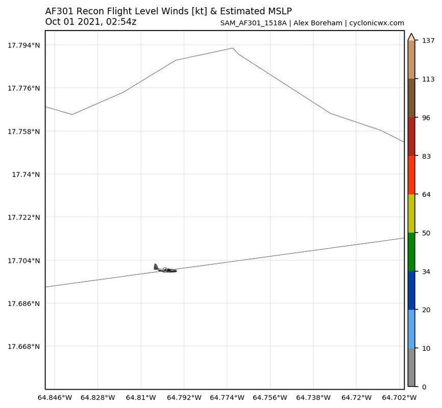
134kt FL in SW quad. SFMR looks to be out of commission, at least for now
0 likes
B.S Meteorology, University of Oklahoma '25
Please refer to the NHC, NWS, or SPC for official information.
Please refer to the NHC, NWS, or SPC for official information.
Re: ATL: SAM - Hurricane - Discussion
At least 130kt according to recon.
0 likes
Personal Forecast Disclaimer:
The posts in this forum are NOT official forecast and should not be used as such. They are just the opinion of the poster and may or may not be backed by sound meteorological data. They are NOT endorsed by any professional institution or storm2k.org. For official information, please refer to RSMC and NWS products.
The posts in this forum are NOT official forecast and should not be used as such. They are just the opinion of the poster and may or may not be backed by sound meteorological data. They are NOT endorsed by any professional institution or storm2k.org. For official information, please refer to RSMC and NWS products.
-
ElectricStorm
- Category 5
- Posts: 5147
- Age: 25
- Joined: Tue Aug 13, 2019 11:23 pm
- Location: Norman, OK
Re: ATL: SAM - Hurricane - Discussion
147kt FL
0 likes
B.S Meteorology, University of Oklahoma '25
Please refer to the NHC, NWS, or SPC for official information.
Please refer to the NHC, NWS, or SPC for official information.
-
ElectricStorm
- Category 5
- Posts: 5147
- Age: 25
- Joined: Tue Aug 13, 2019 11:23 pm
- Location: Norman, OK
Re: ATL: SAM - Hurricane - Discussion
935.4 extrap
0 likes
B.S Meteorology, University of Oklahoma '25
Please refer to the NHC, NWS, or SPC for official information.
Please refer to the NHC, NWS, or SPC for official information.
-
grapealcoholic
- Category 2
- Posts: 703
- Joined: Tue Aug 10, 2021 3:26 pm
-
ElectricStorm
- Category 5
- Posts: 5147
- Age: 25
- Joined: Tue Aug 13, 2019 11:23 pm
- Location: Norman, OK
Re: ATL: SAM - Hurricane - Discussion
Eye temp up to +18.4C on ADT
0 likes
B.S Meteorology, University of Oklahoma '25
Please refer to the NHC, NWS, or SPC for official information.
Please refer to the NHC, NWS, or SPC for official information.
-
Sciencerocks
- Category 5
- Posts: 10186
- Age: 40
- Joined: Thu Jul 06, 2017 1:51 am
Re: ATL: SAM - Hurricane - Discussion
Borderline for 135 knts. We'll see if we can get it up to 140knts with new passes during this mission or not.
0 likes
-
ElectricStorm
- Category 5
- Posts: 5147
- Age: 25
- Joined: Tue Aug 13, 2019 11:23 pm
- Location: Norman, OK
Re: ATL: SAM - Hurricane - Discussion
Hurricane Sam Intermediate Advisory Number 34A
NWS National Hurricane Center Miami FL AL182021
200 AM AST Fri Oct 01 2021
...AIR FORCE RESERVE HURRICANE HUNTER AIRCRAFT FINDS SAM A LITTLE
STRONGER...
SUMMARY OF 200 AM AST...0600 UTC...INFORMATION
----------------------------------------------
LOCATION...25.6N 61.6W
ABOUT 505 MI...810 KM SSE OF BERMUDA
MAXIMUM SUSTAINED WINDS...150 MPH...240 KM/H
PRESENT MOVEMENT...NNW OR 345 DEGREES AT 16 MPH...26 KM/H
MINIMUM CENTRAL PRESSURE...936 MB...27.64 INCHES
1 likes
B.S Meteorology, University of Oklahoma '25
Please refer to the NHC, NWS, or SPC for official information.
Please refer to the NHC, NWS, or SPC for official information.
-
AxaltaRacing24
- Category 5
- Posts: 1774
- Age: 25
- Joined: Wed Jul 27, 2016 11:14 am
- Location: Jupiter, FL
Re: ATL: SAM - Hurricane - Discussion
Weather Dude wrote:Hurricane Sam Intermediate Advisory Number 34A
NWS National Hurricane Center Miami FL AL182021
200 AM AST Fri Oct 01 2021
...AIR FORCE RESERVE HURRICANE HUNTER AIRCRAFT FINDS SAM A LITTLE
STRONGER...
SUMMARY OF 200 AM AST...0600 UTC...INFORMATION
----------------------------------------------
LOCATION...25.6N 61.6W
ABOUT 505 MI...810 KM SSE OF BERMUDA
MAXIMUM SUSTAINED WINDS...150 MPH...240 KM/H
PRESENT MOVEMENT...NNW OR 345 DEGREES AT 16 MPH...26 KM/H
MINIMUM CENTRAL PRESSURE...936 MB...27.64 INCHES
Easily the most impressive longtracker since Irma/Jose
4 likes
-
grapealcoholic
- Category 2
- Posts: 703
- Joined: Tue Aug 10, 2021 3:26 pm
-
Shell Mound
- Category 5
- Posts: 2432
- Age: 33
- Joined: Thu Sep 07, 2017 3:39 pm
- Location: St. Petersburg, FL → Scandinavia
Re: ATL: SAM - Hurricane - Discussion
This is easily the weakest-looking 130-kt system that I have seen on satellite, given lingering southwestern shear, the large, some what ragged eye, and the fairly warm, expansive CDO. Dorian, by contrast, was less sheared and far better organized. I wonder whether those FL winds are mixing to the surface. Also, 936 mb is a relatively high MSLP for a large 130-kt system at Sam's current cooordinates, near the subtropics. I am not a professional, of course, but maybe surface winds are lower than FL would suggest.
1 likes
CVW / MiamiensisWx / Shell Mound
The posts in this forum are NOT official forecasts and should not be used as such. They are just the opinion of the poster and may or may not be backed by sound meteorological data. They are NOT endorsed by any professional institution or STORM2K. For official information, please refer to products from the NHC and NWS.
Who is online
Users browsing this forum: No registered users and 31 guests