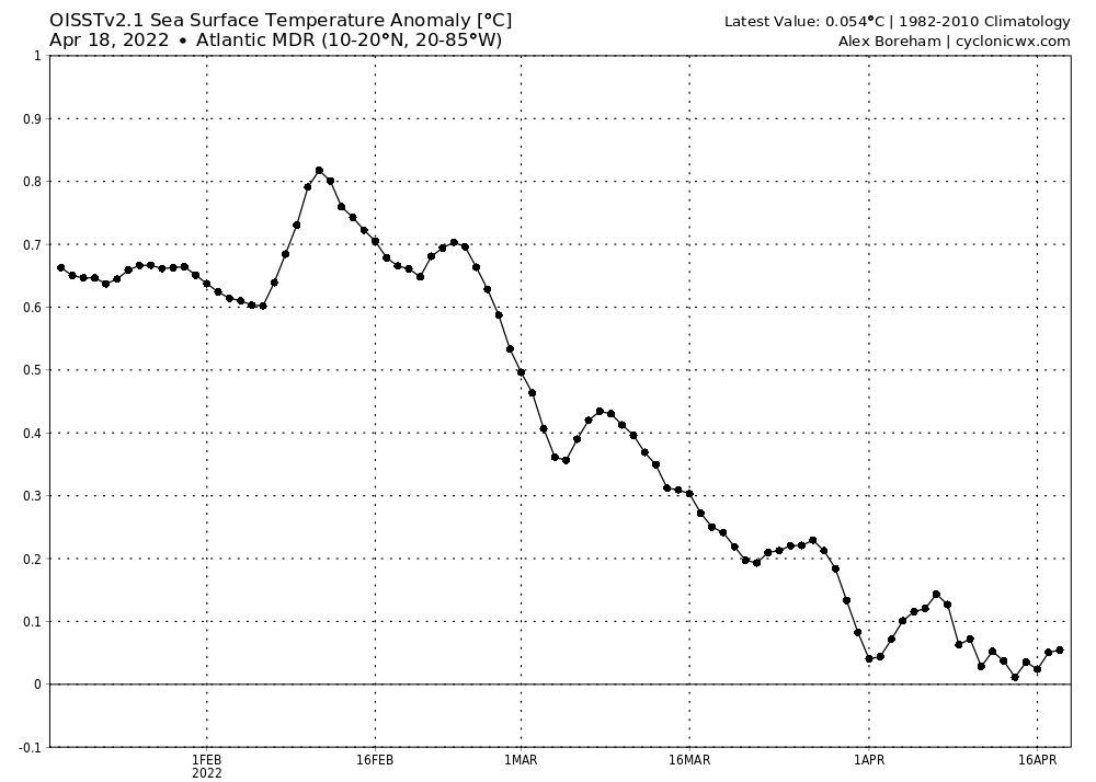
2022 Indicators (SSTs/SAL/MSLP/Shear/Steering/Instability) and >Day 16 Models

This is the general tropical discussion area. Anyone can take their shot at predicting a storms path.

Moderator: S2k Moderators

Forum rules

The posts in this forum are NOT official forecasts and should not be used as such. They are just the opinion of the poster and may or may not be backed by sound meteorological data. They are NOT endorsed by any professional institution or STORM2K. For official information, please refer to products from the National Hurricane Center and National Weather Service.

Help Support Storm2K
Message
Author
User avatar
Kingarabian
S2K Supporter
S2K Supporter
Posts: 15980
Joined: Sat Aug 08, 2009 3:06 am
Location: Honolulu, Hawaii

Re: 2022 indicators: SSTs / SAL / MSLP / shear / steering / instability / images

#401 Postby Kingarabian » Mon Apr 18, 2022 4:03 am

Yellow Evan wrote:
Kingarabian wrote:

Also keep in mind these years were impacted some way or another by +ENSO/El Nino. That won't be the case this year.


2016 and 2021 were not affected by Nino.

ENSO is part ocean part atmosphere. 2016 had clear lingering atmospheric super El Nino effects even if the ocean didn't reflect it. The Atlantic was limited due to it, with El Nino-esque shear and sinking motion shutting down the season until Matthew and Nicole formed. Per some agencies (BOM), 2021 was affected by +ENSO during MJJ. Point is, ENSO will be far more conducive for the Atlantic hurricane season compared to 2016, 2019, and 2021, so it is something to factor regardless of the AMO similarities with those years.
7 likes   
RIP Kobe Bryant

User avatar
weeniepatrol
Category 5
Category 5
Posts: 1273
Joined: Sat Aug 22, 2020 5:30 pm
Location: WA State

Re: 2022 indicators: SSTs / SAL / MSLP / shear / steering / instability / images

#402 Postby weeniepatrol » Mon Apr 18, 2022 4:48 am

skyline385 wrote:
2020 was impacted by +ENSO? Sure didn't feel like it.
By mid-April, the entire NATL was burning in 2020. 2022 doesn't even look close to it and while I am sure this will be another above-average or close to hyperactive season, there would need to be some insane warming of the NATL in the next months to beat 2020. 2020 had so much cyclogenesis that we constantly had tons of multiple systems and centers within monsoon troughs fighting each other.


Well the upcoming pattern features very weak trades in the MDR. Looks similar to 1995 around this time of date. Here's a very stupid and very-not-to-be-taken-seriously meme:

Image

10 days is not a long time, so we'll have to see how long this pattern continues for. If May looks similar then I would expect a rapidly warming MDR by June...
7 likes   

User avatar
weeniepatrol
Category 5
Category 5
Posts: 1273
Joined: Sat Aug 22, 2020 5:30 pm
Location: WA State

Re: 2022 indicators: SSTs / SAL / MSLP / shear / steering / instability / images

#403 Postby weeniepatrol » Mon Apr 18, 2022 4:50 am

Image

:sun:
2 likes   

AlphaToOmega
Category 5
Category 5
Posts: 1448
Joined: Sat Jun 26, 2021 10:51 am
Location: Somewhere in Massachusetts

Re: 2022 indicators: SSTs / SAL / MSLP / shear / steering / instability / images

#404 Postby AlphaToOmega » Mon Apr 18, 2022 5:24 am

NotSparta wrote:


That second one was just sarcastic lol - the MDR is cool yes but we are by no means in a -AMO. It's a pretty good reflection of that 2nd EOF +AMO


The MDR might warm up because of the weaker trade winds.
1 likes   

User avatar
NotSparta
Professional-Met
Professional-Met
Posts: 1668
Age: 23
Joined: Fri Aug 18, 2017 8:24 am
Location: Naples, FL
Contact:

Re: 2022 indicators: SSTs / SAL / MSLP / shear / steering / instability / images

#405 Postby NotSparta » Mon Apr 18, 2022 8:19 am

AlphaToOmega wrote:
NotSparta wrote:


That second one was just sarcastic lol - the MDR is cool yes but we are by no means in a -AMO. It's a pretty good reflection of that 2nd EOF +AMO


The MDR might warm up because of the weaker trade winds.


Yes, it is still cool now but I'm interested in seeing what happens with this bout if weak trades. Could manage to reverse a good amount of that cooling
0 likes   
This post was probably an opinion of mine, and in no way is official. Please refer to http://www.hurricanes.gov for official tropical analysis and advisories.

My website, with lots of tropical wx graphics, including satellite and recon: http://cyclonicwx.com

Shell Mound
Category 5
Category 5
Posts: 2434
Age: 32
Joined: Thu Sep 07, 2017 3:39 pm
Location: St. Petersburg, FL → Scandinavia

Re: 2022 indicators: SSTs / SAL / MSLP / shear / steering / instability / images

#406 Postby Shell Mound » Mon Apr 18, 2022 9:49 am

NotSparta wrote:
AlphaToOmega wrote:
NotSparta wrote:
That second one was just sarcastic lol - the MDR is cool yes but we are by no means in a -AMO. It's a pretty good reflection of that 2nd EOF +AMO


The MDR might warm up because of the weaker trade winds.

Yes, it is still cool now but I'm interested in seeing what happens with this bout if weak trades. Could manage to reverse a good amount of that cooling

Models have been trending toward a more persistent -NAO through at least early May, along with even lower MSLP and weaker trades over the MDR and eastern Caribbean vs. earlier runs. This pattern would also help to suppress the warm pool over the northwestern North Atlantic, at least to some degree. Already we are observing respectable warming over the eastern subtropical Atlantic and portions of the MDR, concomitantly with cooling over the Sargasso Sea and off the Eastern Seaboard. The equatorial warm pool off the northeastern tip of South America will therefore likely migrate northeastward over the MDR over the next several weeks.
4 likes   
CVW / MiamiensisWx / Shell Mound
The posts in this forum are NOT official forecasts and should not be used as such. They are just the opinion of the poster and may or may not be backed by sound meteorological data. They are NOT endorsed by any professional institution or STORM2K. For official information, please refer to products from the NHC and NWS.

User avatar
Category5Kaiju
Category 5
Category 5
Posts: 4095
Joined: Thu Dec 24, 2020 12:45 pm
Location: Seattle

Re: 2022 indicators: SSTs / SAL / MSLP / shear / steering / instability / images

#407 Postby Category5Kaiju » Mon Apr 18, 2022 11:12 am

Shell Mound wrote:
NotSparta wrote:
AlphaToOmega wrote:
The MDR might warm up because of the weaker trade winds.

Yes, it is still cool now but I'm interested in seeing what happens with this bout if weak trades. Could manage to reverse a good amount of that cooling

Models have been trending toward a more persistent -NAO through at least early May, along with even lower MSLP and weaker trades over the MDR and eastern Caribbean vs. earlier runs. This pattern would also help to suppress the warm pool over the northwestern North Atlantic, at least to some degree. Already we are observing respectable warming over the eastern subtropical Atlantic and portions of the MDR, concomitantly with cooling over the Sargasso Sea and off the Eastern Seaboard. The equatorial warm pool off the northeastern tip of South America will therefore likely migrate northeastward over the MDR over the next several weeks.


Oh yeah, no I agree with you on this Shell Mound. The NOAA sst anomaly map really shows that warming has begun, with the north part of South America especially turning orange. Also I will add that the Gulf is seeing some robust warming too. It's only a matter of time imho that the MDR flashes orange and has people in the 2022 season poll jacking up their prediction numbers for this season :D
0 likes   
Unless explicitly stated, all info in my posts is based on my own opinions and observations. Tropical storms and hurricanes can be extremely dangerous. Do not think you can beat Mother Nature. Refer to an accredited weather research agency or meteorologist if you need to make serious decisions regarding an approaching storm.

User avatar
NotSparta
Professional-Met
Professional-Met
Posts: 1668
Age: 23
Joined: Fri Aug 18, 2017 8:24 am
Location: Naples, FL
Contact:

Re: 2022 indicators: SSTs / SAL / MSLP / shear / steering / instability / images

#408 Postby NotSparta » Mon Apr 18, 2022 11:43 am

Shell Mound wrote:
NotSparta wrote:
AlphaToOmega wrote:
The MDR might warm up because of the weaker trade winds.

Yes, it is still cool now but I'm interested in seeing what happens with this bout if weak trades. Could manage to reverse a good amount of that cooling

Models have been trending toward a more persistent -NAO through at least early May, along with even lower MSLP and weaker trades over the MDR and eastern Caribbean vs. earlier runs. This pattern would also help to suppress the warm pool over the northwestern North Atlantic, at least to some degree. Already we are observing respectable warming over the eastern subtropical Atlantic and portions of the MDR, concomitantly with cooling over the Sargasso Sea and off the Eastern Seaboard. The equatorial warm pool off the northeastern tip of South America will therefore likely migrate northeastward over the MDR over the next several weeks.


Yeah the -NAO is certainly an interesting development. We'll see where we are once it winds down I guess. Definitely can see a window where the pattern transforms into a more classical +AMO and the more high end predictions for the season look more likely. We'll just have to wait and watch
1 likes   
This post was probably an opinion of mine, and in no way is official. Please refer to http://www.hurricanes.gov for official tropical analysis and advisories.

My website, with lots of tropical wx graphics, including satellite and recon: http://cyclonicwx.com

zzh
Category 1
Category 1
Posts: 375
Joined: Fri Aug 27, 2021 2:18 pm

Re: 2022 indicators: SSTs / SAL / MSLP / shear / steering / instability / images

#409 Postby zzh » Mon Apr 18, 2022 1:18 pm

Image
Image
What trade?
1 likes   

AlphaToOmega
Category 5
Category 5
Posts: 1448
Joined: Sat Jun 26, 2021 10:51 am
Location: Somewhere in Massachusetts

Re: 2022 indicators: SSTs / SAL / MSLP / shear / steering / instability / images

#410 Postby AlphaToOmega » Mon Apr 18, 2022 2:25 pm

Interestingly, this pattern has been ongoing for over a week, but little has actually changed.
Image
0 likes   

User avatar
Category5Kaiju
Category 5
Category 5
Posts: 4095
Joined: Thu Dec 24, 2020 12:45 pm
Location: Seattle

Re: 2022 indicators: SSTs / SAL / MSLP / shear / steering / instability / images

#411 Postby Category5Kaiju » Mon Apr 18, 2022 2:29 pm

AlphaToOmega wrote:Interestingly, this pattern has been ongoing for over a week, but little has actually changed.
https://i.postimg.cc/mrJq05Jz/ssta-graph-atlmdr.png


I am pretty sure that we were not in a -NAO until right around now, which is when we should be transitioning to +NAO and seeing much more noticeable warming

Edit: shoot, sorry, I think I meant the other way around. If I am not mistaken, +NAO favors trades while -NAO doesn't?
Last edited by Category5Kaiju on Mon Apr 18, 2022 2:39 pm, edited 1 time in total.
0 likes   
Unless explicitly stated, all info in my posts is based on my own opinions and observations. Tropical storms and hurricanes can be extremely dangerous. Do not think you can beat Mother Nature. Refer to an accredited weather research agency or meteorologist if you need to make serious decisions regarding an approaching storm.

User avatar
skyline385
Category 5
Category 5
Posts: 2728
Age: 35
Joined: Wed Aug 26, 2020 11:15 pm
Location: Houston TX

2022 indicators: SSTs / SAL / MSLP / shear / steering / instability / images

#412 Postby skyline385 » Mon Apr 18, 2022 2:37 pm

Slightly different take from Philip

https://twitter.com/philklotzbach/statu ... 7107191811

Except 1988 and 1989, all others had a large number of majors.
0 likes   

zzh
Category 1
Category 1
Posts: 375
Joined: Fri Aug 27, 2021 2:18 pm

Re: 2022 indicators: SSTs / SAL / MSLP / shear / steering / instability / images

#413 Postby zzh » Mon Apr 18, 2022 2:48 pm

AlphaToOmega wrote:Interestingly, this pattern has been ongoing for over a week, but little has actually changed.
https://i.postimg.cc/mrJq05Jz/ssta-graph-atlmdr.png

Image
Because weak trades were only in Eastern tropical Atlantic...
Image
We can clearly see warming in Eastern tropical Atlantic, it correlates with 850U pretty well.
Strong trades were over the Caribbean, that's why the OVERALL MDR SSTA didn't change that much. This pattern is expected to change with weak trades in the entire MDR.
9 likes   

User avatar
Category5Kaiju
Category 5
Category 5
Posts: 4095
Joined: Thu Dec 24, 2020 12:45 pm
Location: Seattle

Re: 2022 indicators: SSTs / SAL / MSLP / shear / steering / instability / images

#414 Postby Category5Kaiju » Mon Apr 18, 2022 2:52 pm

skyline385 wrote:Slightly different take from Philip

https://twitter.com/philklotzbach/statu ... 7107191811

Except 1988 and 1989, all others had a large number of majors.


Even then, 1988 had Gilbert and Joan while 1989 had Hugo. In other words, both of those years featured their fair share of very damaging and powerful storms despite being in a -AMO period!
1 likes   
Unless explicitly stated, all info in my posts is based on my own opinions and observations. Tropical storms and hurricanes can be extremely dangerous. Do not think you can beat Mother Nature. Refer to an accredited weather research agency or meteorologist if you need to make serious decisions regarding an approaching storm.

User avatar
skyline385
Category 5
Category 5
Posts: 2728
Age: 35
Joined: Wed Aug 26, 2020 11:15 pm
Location: Houston TX

Re: 2022 indicators: SSTs / SAL / MSLP / shear / steering / instability / images

#415 Postby skyline385 » Mon Apr 18, 2022 3:36 pm

Category5Kaiju wrote:
skyline385 wrote:Slightly different take from Philip

https://twitter.com/philklotzbach/statu ... 7107191811

Except 1988 and 1989, all others had a large number of majors.


Even then, 1988 had Gilbert and Joan while 1989 had Hugo. In other words, both of those years featured their fair share of very damaging and powerful storms despite being in a -AMO period!

Well Andy and Alex seem to think that early season will see MDR stability and a lot of those seasons did have MDR runners.

https://twitter.com/andyhazelton/status ... 3398397954
0 likes   

User avatar
NotSparta
Professional-Met
Professional-Met
Posts: 1668
Age: 23
Joined: Fri Aug 18, 2017 8:24 am
Location: Naples, FL
Contact:

Re: 2022 indicators: SSTs / SAL / MSLP / shear / steering / instability / images

#416 Postby NotSparta » Mon Apr 18, 2022 3:43 pm

skyline385 wrote:
Category5Kaiju wrote:
skyline385 wrote:Slightly different take from Philip

https://twitter.com/philklotzbach/statu ... 7107191811

Except 1988 and 1989, all others had a large number of majors.


Even then, 1988 had Gilbert and Joan while 1989 had Hugo. In other words, both of those years featured their fair share of very damaging and powerful storms despite being in a -AMO period!

Well Andy and Alex seem to think that early season will see MDR stability and a lot of those seasons did have MDR runners.

https://twitter.com/andyhazelton/status ... 3398397954


Condition for that is the MDR remains cooler than the subtropics. If we see that reverse or the MDR being even on the subtropics (perhaps due to the -NAO) then I don't see stability being as much a problem
0 likes   
This post was probably an opinion of mine, and in no way is official. Please refer to http://www.hurricanes.gov for official tropical analysis and advisories.

My website, with lots of tropical wx graphics, including satellite and recon: http://cyclonicwx.com

User avatar
skyline385
Category 5
Category 5
Posts: 2728
Age: 35
Joined: Wed Aug 26, 2020 11:15 pm
Location: Houston TX

Re: 2022 indicators: SSTs / SAL / MSLP / shear / steering / instability / images

#417 Postby skyline385 » Mon Apr 18, 2022 4:08 pm

NotSparta wrote:
skyline385 wrote:
Category5Kaiju wrote:
Even then, 1988 had Gilbert and Joan while 1989 had Hugo. In other words, both of those years featured their fair share of very damaging and powerful storms despite being in a -AMO period!

Well Andy and Alex seem to think that early season will see MDR stability and a lot of those seasons did have MDR runners.

https://twitter.com/andyhazelton/status ... 3398397954


Condition for that is the MDR remains cooler than the subtropics. If we see that reverse or the MDR being even on the subtropics (perhaps due to the -NAO) then I don't see stability being as much a problem

Yea and that's a pretty big IF for now. There are some signs of the MDR starting to warm up but still got to wait and see. Also the average SST based on climo also goes up as we approach June so even if the MDR is warming a bit it could still be lower than historical average no?
0 likes   

AlphaToOmega
Category 5
Category 5
Posts: 1448
Joined: Sat Jun 26, 2021 10:51 am
Location: Somewhere in Massachusetts

Re: 2022 indicators: SSTs / SAL / MSLP / shear / steering / instability / images

#418 Postby AlphaToOmega » Mon Apr 18, 2022 4:58 pm

skyline385 wrote:
NotSparta wrote:
skyline385 wrote:Well Andy and Alex seem to think that early season will see MDR stability and a lot of those seasons did have MDR runners.

https://twitter.com/andyhazelton/status ... 3398397954


Condition for that is the MDR remains cooler than the subtropics. If we see that reverse or the MDR being even on the subtropics (perhaps due to the -NAO) then I don't see stability being as much a problem

Yea and that's a pretty big IF for now. There are some signs of the MDR starting to warm up but still got to wait and see. Also the average SST based on climo also goes up as we approach June so even if the MDR is warming a bit it could still be lower than historical average no?


That is possible, but the -NAO is probably going increase MDR SSTAs, which means increasing MDR SSTs relative to average. While we know the MDR is definitely going to be above-average in terms of SSTAs by ASO, if the MDR is above-average by June, the WAM will make the MDR even more above-average by ASO.
0 likes   

User avatar
aspen
Category 5
Category 5
Posts: 8818
Joined: Sat Oct 12, 2019 7:10 pm
Location: Connecticut, USA

Re: 2022 indicators: SSTs / SAL / MSLP / shear / steering / instability / images

#419 Postby aspen » Mon Apr 18, 2022 5:41 pm

skyline385 wrote:Slightly different take from Philip

https://twitter.com/philklotzbach/statu ... 7107191811

Except 1988 and 1989, all others had a large number of majors.

Most of those years had at least one long-tracking major from the MDR (not all peaked in the MDR though), and three of them (1985, 1999, and 2011) had an “East Coast Sweeper” storm (Gloria, Floyd, and Irene). I wonder if these kinds of tracks are correlated with second or third year Ninas.
0 likes   
Irene '11 Sandy '12 Hermine '16 5/15/2018 Derecho Fay '20 Isaias '20 Elsa '21 Henri '21 Ida '21

I am only a meteorology enthusiast who knows a decent amount about tropical cyclones. Look to the professional mets, the NHC, or your local weather office for the best information.

User avatar
skyline385
Category 5
Category 5
Posts: 2728
Age: 35
Joined: Wed Aug 26, 2020 11:15 pm
Location: Houston TX

Re: 2022 indicators: SSTs / SAL / MSLP / shear / steering / instability / images

#420 Postby skyline385 » Mon Apr 18, 2022 5:50 pm

aspen wrote:
skyline385 wrote:Slightly different take from Philip

https://twitter.com/philklotzbach/statu ... 7107191811

Except 1988 and 1989, all others had a large number of majors.

Most of those years had at least one long-tracking major from the MDR (not all peaked in the MDR though), and three of them (1985, 1999, and 2011) had an “East Coast Sweeper” storm (Gloria, Floyd, and Irene). I wonder if these kinds of tracks are correlated with second or third year Ninas.


They does seem to be a theme, Andy was joking about Dorian 2.0 in a different tweet as well.
0 likes   


Return to “Talkin' Tropics”

Who is online

Users browsing this forum: gib, Hurricane2022, HurricaneFan, RomP and 56 guests