2022 Indicators (SSTs/SAL/MSLP/Shear/Steering/Instability) and >Day 16 Models
Moderator: S2k Moderators
Forum rules

The posts in this forum are NOT official forecasts and should not be used as such. They are just the opinion of the poster and may or may not be backed by sound meteorological data. They are NOT endorsed by any professional institution or STORM2K. For official information, please refer to products from the National Hurricane Center and National Weather Service.
-
AlphaToOmega
- Category 5

- Posts: 1448
- Joined: Sat Jun 26, 2021 10:51 am
- Location: Somewhere in Massachusetts
Re: 2022 indicators: SSTs / SAL / MSLP / shear / steering / instability / images
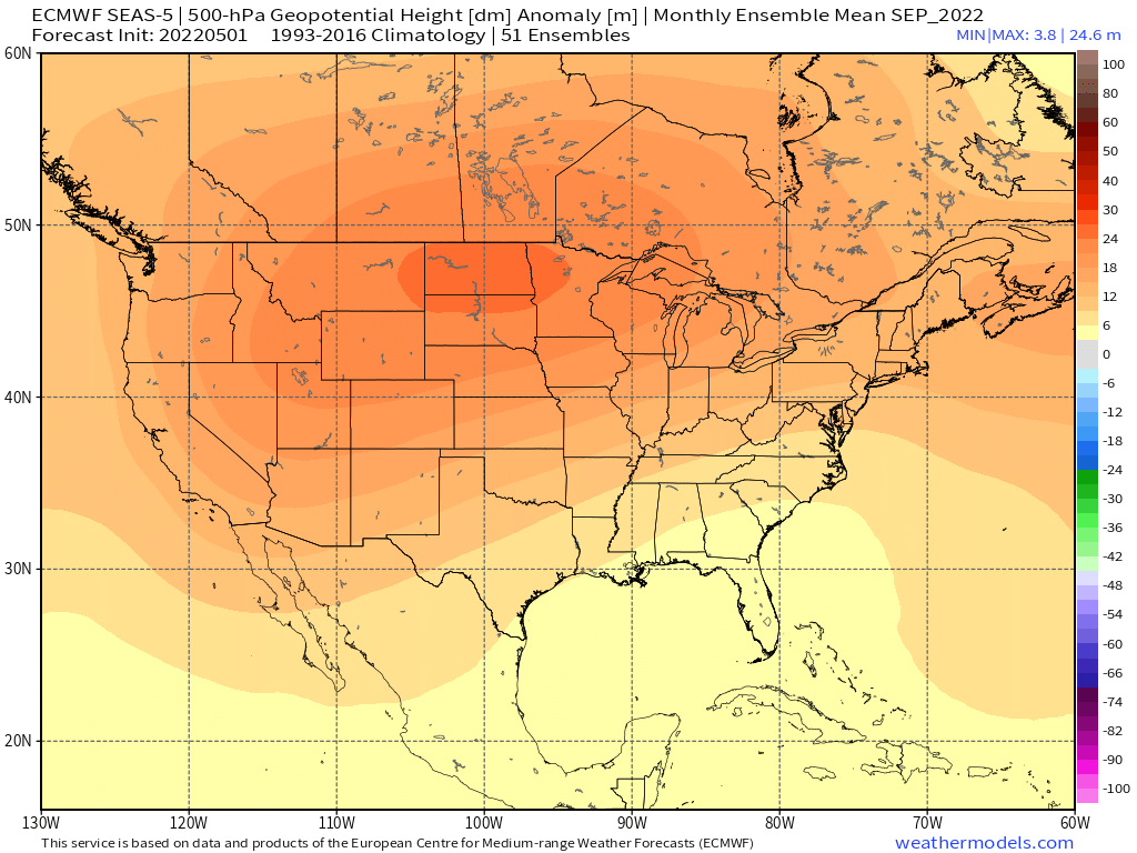
Something is definitely fishy about the ECMWF. It shows a -AMM horseshoe during the peak season, yet it shows an ACE 130% the 1993-2016 average.
0 likes
-
SFLcane

- S2K Supporter

- Posts: 10281
- Age: 48
- Joined: Sat Jun 05, 2010 1:44 pm
- Location: Lake Worth Florida
Re: 2022 indicators: SSTs / SAL / MSLP / shear / steering / instability / images
AlphaToOmega wrote:Something is definitely fishy about the ECMWF. It shows a -AMM horseshoe during the peak season, yet it shows an ACE 130% the 1993-2016 average.
it's going heavy on the Caribbean which Makes sense given the strong ridge over the entire CONUS.
1 likes
-
SFLcane
- S2K Supporter
- Posts: 10281
- Age: 48
- Joined: Sat Jun 05, 2010 1:44 pm
- Location: Lake Worth Florida
Re: 2022 indicators: SSTs / SAL / MSLP / shear / steering / instability / images
I think it should cause those who have been predicting hyperactivity to slow down.
1 likes
-
cycloneye

- Admin

- Posts: 149719
- Age: 69
- Joined: Thu Oct 10, 2002 10:54 am
- Location: San Juan, Puerto Rico
Re: 2022 indicators: SSTs / SAL / MSLP / shear / steering / instability / images
SFLcane wrote:I think it should cause those who have been predicting hyperactivity to slow down.
Some private companys went very high on numbers and ACE. Waiting for NOAA in the next few days. See Expert forecasts thread
1 likes
Visit the Caribbean-Central America Weather Thread where you can find at first post web cams,radars
and observations from Caribbean basin members Click Here
and observations from Caribbean basin members Click Here
-
AlphaToOmega
- Category 5
- Posts: 1448
- Joined: Sat Jun 26, 2021 10:51 am
- Location: Somewhere in Massachusetts
Re: 2022 indicators: SSTs / SAL / MSLP / shear / steering / instability / images
We need to see what this does:
4 likes
-
DorkyMcDorkface

- Category 5
- Posts: 1043
- Age: 28
- Joined: Mon Sep 30, 2019 1:32 pm
- Location: Mid-Atlantic
Re: 2022 indicators: SSTs / SAL / MSLP / shear / steering / instability / images
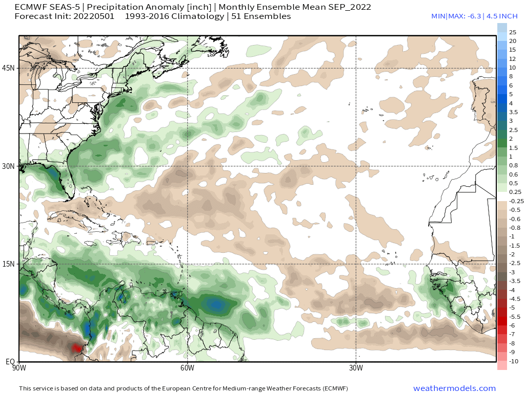
DorkyMcDorkface wrote:A little confused at the SEAS5's graphically bearish signal in tandem with an ACE prediction of 130% of average. Unless it's expecting a bunch of Caribbean Cruisers it doesn't make a lot of sense to me...
https://cdn.discordapp.com/attachments/733552978572869632/971770953979813908/ps2png-worker-commands-7c47f6996d-7pm8d-6fe5cac1a363ec1525f54343b6cc9fd8-LVjH_T.png
https://cdn.discordapp.com/attachments/733552978572869632/971796572893487144/20220505_113232.jpg
Another oddity is that the WAM seems unusually weak, at least for this current era we're in.

1 likes
Please note the thoughts expressed by this account are solely those of the user and are from a hobbyist perspective. For more comprehensive analysis, consult an actual professional meteorologist or meteorological agency.
Floyd 1999 | Isabel 2003 | Hanna 2008 | Irene 2011 | Sandy 2012 | Isaias 2020
-
Category5Kaiju

- Category 5
- Posts: 4346
- Joined: Thu Dec 24, 2020 12:45 pm
- Location: Seattle during the summer, Phoenix during the winter
Re: 2022 indicators: SSTs / SAL / MSLP / shear / steering / instability / images
DorkyMcDorkface wrote:DorkyMcDorkface wrote:A little confused at the SEAS5's graphically bearish signal in tandem with an ACE prediction of 130% of average. Unless it's expecting a bunch of Caribbean Cruisers it doesn't make a lot of sense to me...
https://cdn.discordapp.com/attachments/733552978572869632/971770953979813908/ps2png-worker-commands-7c47f6996d-7pm8d-6fe5cac1a363ec1525f54343b6cc9fd8-LVjH_T.png
https://cdn.discordapp.com/attachments/733552978572869632/971796572893487144/20220505_113232.jpg
Another oddity is that the WAM seems unusually weak, at least for this current era we're in.
https://cdn.discordapp.com/attachments/733552978572869632/971827046533697566/seas5_qpfa_3mon_nafrica_ASO.png
Wait...what??
Yeah, I am not sure if that will pan out, unless something happens and the strong WAM we've been consistently seeing the past years suddenly falters.
0 likes
Unless explicitly stated, all information in my posts is based on my own opinions and observations. Tropical storms and hurricanes can be extremely dangerous. Refer to an accredited weather research agency or meteorologist if you need to make serious decisions regarding an approaching storm.
-
cycloneye
- Admin
- Posts: 149719
- Age: 69
- Joined: Thu Oct 10, 2002 10:54 am
- Location: San Juan, Puerto Rico
Re: 2022 indicators: SSTs / SAL / MSLP / shear / steering / instability / images
ECMWF=165 ACE. Those peeps worried dont panic. 
https://twitter.com/philklotzbach/status/1522271780542558211
https://twitter.com/philklotzbach/status/1522271780542558211
0 likes
Visit the Caribbean-Central America Weather Thread where you can find at first post web cams,radars
and observations from Caribbean basin members Click Here
and observations from Caribbean basin members Click Here
-
AlphaToOmega
- Category 5
- Posts: 1448
- Joined: Sat Jun 26, 2021 10:51 am
- Location: Somewhere in Massachusetts
Re: 2022 indicators: SSTs / SAL / MSLP / shear / steering / instability / images
cycloneye wrote:ECMWF=165 ACE. Those peeps worried dont panic.
https://twitter.com/philklotzbach/status/1522271780542558211
I wonder why the ECMWF outputs ACE at a percentage of a climatological mean instead of outputting a raw ACE value.
0 likes

Re: 2022 indicators: SSTs / SAL / MSLP / shear / steering / instability / images
cycloneye wrote:ECMWF=165 ACE. Those peeps worried dont panic.
https://twitter.com/philklotzbach/status/1522271780542558211
So this month’s ECMWF run predicts a lack of a +AMO and a nearly dead ITCZ…and yet it still gets 165 ACE. Unless we’re missing something, this run doesn’t make a ton of sense.
0 likes
Irene '11 Sandy '12 Hermine '16 5/15/2018 Derecho Fay '20 Isaias '20 Elsa '21 Henri '21 Ida '21
I am only a meteorology enthusiast who knows a decent amount about tropical cyclones. Look to the professional mets, the NHC, or your local weather office for the best information.
I am only a meteorology enthusiast who knows a decent amount about tropical cyclones. Look to the professional mets, the NHC, or your local weather office for the best information.
-
DorkyMcDorkface
- Category 5
- Posts: 1043
- Age: 28
- Joined: Mon Sep 30, 2019 1:32 pm
- Location: Mid-Atlantic
Re: 2022 indicators: SSTs / SAL / MSLP / shear / steering / instability / images
AlphaToOmega wrote:cycloneye wrote:ECMWF=165 ACE. Those peeps worried dont panic.
https://twitter.com/philklotzbach/status/1522271780542558211
I wonder why the ECMWF outputs ACE at a percentage of a climatological mean instead of outputting a raw ACE value.
I think my biggest question is why they're using that climo in particular. 1993-2021 is overwhelmingly +AMO.
0 likes
Please note the thoughts expressed by this account are solely those of the user and are from a hobbyist perspective. For more comprehensive analysis, consult an actual professional meteorologist or meteorological agency.
Floyd 1999 | Isabel 2003 | Hanna 2008 | Irene 2011 | Sandy 2012 | Isaias 2020
-
Category5Kaiju
- Category 5
- Posts: 4346
- Joined: Thu Dec 24, 2020 12:45 pm
- Location: Seattle during the summer, Phoenix during the winter
Re: 2022 indicators: SSTs / SAL / MSLP / shear / steering / instability / images
aspen wrote:cycloneye wrote:ECMWF=165 ACE. Those peeps worried dont panic.
https://twitter.com/philklotzbach/status/1522271780542558211
So this month’s ECMWF run predicts a lack of a +AMO and a nearly dead ITCZ…and yet it still gets 165 ACE. Unless we’re missing something, this run doesn’t make a ton of sense.
I guarantee you that if we get a hyperactive season despite a -AMO and a dead ITCZ, then this season will go down in history and be talked about as a reference season for many years to come
0 likes
Unless explicitly stated, all information in my posts is based on my own opinions and observations. Tropical storms and hurricanes can be extremely dangerous. Refer to an accredited weather research agency or meteorologist if you need to make serious decisions regarding an approaching storm.
-
SFLcane
- S2K Supporter
- Posts: 10281
- Age: 48
- Joined: Sat Jun 05, 2010 1:44 pm
- Location: Lake Worth Florida
Re: 2022 indicators: SSTs / SAL / MSLP / shear / steering / instability / images
cycloneye wrote:ECMWF=165 ACE. Those peeps worried dont panic.
https://twitter.com/philklotzbach/status/1522271780542558211
Something is off with that ace especially 165 considering everything else its predicting.
0 likes
-
NotSparta

- Professional-Met

- Posts: 1677
- Age: 24
- Joined: Fri Aug 18, 2017 8:24 am
- Location: Naples, FL
- Contact:
Re: 2022 indicators: SSTs / SAL / MSLP / shear / steering / instability / images
aspen wrote:cycloneye wrote:ECMWF=165 ACE. Those peeps worried dont panic.
https://twitter.com/philklotzbach/status/1522271780542558211
So this month’s ECMWF run predicts a lack of a +AMO and a nearly dead ITCZ…and yet it still gets 165 ACE. Unless we’re missing something, this run doesn’t make a ton of sense.
2022 effect. No matter what, models will still print out a hyperactive (>= 160 ACE) season
0 likes
This post was probably an opinion of mine, and in no way is official. Please refer to http://www.hurricanes.gov for official tropical analysis and advisories.
My website, with lots of tropical wx graphics, including satellite and recon: http://cyclonicwx.com
My website, with lots of tropical wx graphics, including satellite and recon: http://cyclonicwx.com
-
AlphaToOmega
- Category 5
- Posts: 1448
- Joined: Sat Jun 26, 2021 10:51 am
- Location: Somewhere in Massachusetts
Re: 2022 indicators: SSTs / SAL / MSLP / shear / steering / instability / images
NotSparta wrote:aspen wrote:cycloneye wrote:ECMWF=165 ACE. Those peeps worried dont panic.
https://twitter.com/philklotzbach/status/1522271780542558211
So this month’s ECMWF run predicts a lack of a +AMO and a nearly dead ITCZ…and yet it still gets 165 ACE. Unless we’re missing something, this run doesn’t make a ton of sense.
2022 effect. No matter what, models will still print out a hyperactive (>= 160 ACE) season
Is the model trying to correct for something? 165 ACE seems reasonable for this season's projected base state for ASO (+AMO, -PDO, +AMM, -ENSO, and Atlantic Nina), but not for the ECMWF's projected base state. Maybe the ECMWF is trying to correct its warm ENSO bias, cool MDR bias, and dry West Africa bias for the hurricane totals but nothing else. If you want to know, ask the people who maintain the ECMWF, not me.
0 likes
-
toad strangler

- S2K Supporter
- Posts: 4546
- Joined: Sun Jul 28, 2013 3:09 pm
- Location: Earth
- Contact:
Re: ENSO Updates
NotSparta wrote:toad strangler wrote:AutoPenalti wrote:I'm just waiting for someone to say it.
well, that wraps it up. It's over. See you next May!
So I'm kinda old school and lean heavily on CSU and NOAA forecasts as the biggest indicators in my thought process over any modeling. Bullish or Bearish don't matter. So I wait patiently for NOAA to help guide my initial thoughts on the season.
Ironically, part of the reason CSU went so high is because of their modeling
Ya, part. But they aren't cliff jumping weenies like many of us from model to model
4 likes
My Weather Station
https://www.wunderground.com/dashboard/pws/KFLPORTS603
https://www.wunderground.com/dashboard/pws/KFLPORTS603
Re: 2022 indicators: SSTs / SAL / MSLP / shear / steering / instability / images
If the ECMWF is right about a very weak WAM and ITCZ, then there must be something we’re missing right now. Maybe we’ve missed some indicators, or what happened in ON 2021 has led to suppressive impacts for 2022. How has precipitation in Africa this year compare to 2020 and 2021 by this point?
0 likes
Irene '11 Sandy '12 Hermine '16 5/15/2018 Derecho Fay '20 Isaias '20 Elsa '21 Henri '21 Ida '21
I am only a meteorology enthusiast who knows a decent amount about tropical cyclones. Look to the professional mets, the NHC, or your local weather office for the best information.
I am only a meteorology enthusiast who knows a decent amount about tropical cyclones. Look to the professional mets, the NHC, or your local weather office for the best information.
-
Iceresistance

- Category 5
- Posts: 9607
- Age: 22
- Joined: Sat Oct 10, 2020 9:45 am
- Location: Tecumseh, OK/Norman, OK
Re: 2022 indicators: SSTs / SAL / MSLP / shear / steering / instability / images
I'm surprised that no one has noticed how fast the Atlantic MDR warmed, it's +0.5°C warmer compared to Mid-April!
0 likes
Bill 2015 & Beta 2020
Winter 2020-2021
All observations are in Tecumseh, OK unless otherwise noted.
Winter posts are focused mainly for Oklahoma & Texas.
Take any of my forecasts with a grain of salt, refer to the NWS, SPC, and NHC for official information
Never say Never with weather! Because ANYTHING is possible!
Winter 2020-2021
All observations are in Tecumseh, OK unless otherwise noted.
Winter posts are focused mainly for Oklahoma & Texas.
Take any of my forecasts with a grain of salt, refer to the NWS, SPC, and NHC for official information
Never say Never with weather! Because ANYTHING is possible!
-
NotSparta
- Professional-Met
- Posts: 1677
- Age: 24
- Joined: Fri Aug 18, 2017 8:24 am
- Location: Naples, FL
- Contact:
Re: 2022 indicators: SSTs / SAL / MSLP / shear / steering / instability / images
aspen wrote:If the ECMWF is right about a very weak WAM and ITCZ, then there must be something we’re missing right now. Maybe we’ve missed some indicators, or what happened in ON 2021 has led to suppressive impacts for 2022. How has precipitation in Africa this year compare to 2020 and 2021 by this point?
Probably won't be right. The weak WAM is a very well-known ECMWF bias
1 likes
This post was probably an opinion of mine, and in no way is official. Please refer to http://www.hurricanes.gov for official tropical analysis and advisories.
My website, with lots of tropical wx graphics, including satellite and recon: http://cyclonicwx.com
My website, with lots of tropical wx graphics, including satellite and recon: http://cyclonicwx.com
-
NotSparta
- Professional-Met
- Posts: 1677
- Age: 24
- Joined: Fri Aug 18, 2017 8:24 am
- Location: Naples, FL
- Contact:
Re: 2022 indicators: SSTs / SAL / MSLP / shear / steering / instability / images
Iceresistance wrote:I'm surprised that no one has noticed how fast the Atlantic MDR warmed, it's +0.5°C warmer compared to Mid-April!
What do you mean? When it was still warming that's all everyone was talking about lol
1 likes
This post was probably an opinion of mine, and in no way is official. Please refer to http://www.hurricanes.gov for official tropical analysis and advisories.
My website, with lots of tropical wx graphics, including satellite and recon: http://cyclonicwx.com
My website, with lots of tropical wx graphics, including satellite and recon: http://cyclonicwx.com
Who is online
Users browsing this forum: Google [Bot] and 134 guests