2022 Global Model Runs Discussion (Out thru day 16)

This is the general tropical discussion area. Anyone can take their shot at predicting a storms path.

Moderator: S2k Moderators

Forum rules

The posts in this forum are NOT official forecasts and should not be used as such. They are just the opinion of the poster and may or may not be backed by sound meteorological data. They are NOT endorsed by any professional institution or STORM2K. For official information, please refer to products from the National Hurricane Center and National Weather Service.

Help Support Storm2K
Message
Author
User avatar
Nimbus
Category 5
Category 5
Posts: 5300
Joined: Mon Jul 19, 2004 10:54 am

Re: 2022 Global Model Runs Discussion (Out thru day 16)

#621 Postby Nimbus » Thu Jun 09, 2022 6:16 am

Europa non è lontana wrote:00z GFS continues to model development in the western Caribbean at around +180, but it's an outlier; only one other model from this morning's runs and the 12z runs yesterday show this solution. Other models have the precursor disturbance moving into the Pacific before developing.


I'm not sure why they run these models more than 10 days out, unless there is an African wave train with very stable upper air pattern locked in place they aren't worth much.
3 likes   

User avatar
Blown Away
S2K Supporter
S2K Supporter
Posts: 10146
Joined: Wed May 26, 2004 6:17 am

Re: 2022 Global Model Runs Discussion (Out thru day 16)

#622 Postby Blown Away » Thu Jun 09, 2022 6:53 am

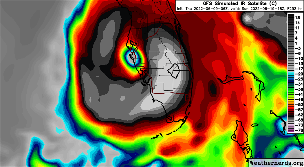
Image
06z GFS
1 likes   
Hurricane Eye Experience: David 79, Irene 99, Frances 04, Jeanne 04, Wilma 05... EYE COMING MY WAY IN 2024…
Hurricane Brush Experience: Andrew 92, Erin 95, Floyd 99, Matthew 16, Irma 17, Ian 22, Nicole 22…

User avatar
skyline385
Category 5
Category 5
Posts: 2728
Age: 35
Joined: Wed Aug 26, 2020 11:15 pm
Location: Houston TX

Re: 2022 Global Model Runs Discussion (Out thru day 16)

#623 Postby skyline385 » Thu Jun 09, 2022 6:56 am

06Z GFS sure loves Florida
0 likes   

User avatar
InfernoFlameCat
Category 5
Category 5
Posts: 2102
Age: 22
Joined: Mon Dec 14, 2020 10:52 am
Location: Buford, GA

Re: 2022 Global Model Runs Discussion (Out thru day 16)

#624 Postby InfernoFlameCat » Thu Jun 09, 2022 7:14 am

skyline385 wrote:06Z GFS sure loves Florida

It’s like it wants to make up for all those years without a landfall on Tampa.
0 likes   
I am by no means a professional. DO NOT look at my forecasts for official information or make decisions based on what I post.

Goal: to become a registered expert over tropical and subtropical cyclones.

hurricane2025
Tropical Storm
Tropical Storm
Posts: 209
Joined: Thu Apr 08, 2021 10:36 am

Re: 2022 Global Model Runs Discussion (Out thru day 16)

#625 Postby hurricane2025 » Thu Jun 09, 2022 7:32 am

If I was a betting man pacific storm or Mexico to south texas
0 likes   

User avatar
Cpv17
Category 5
Category 5
Posts: 4979
Joined: Wed Dec 07, 2016 2:24 pm
Location: Wharton/El Campo, TX

Re: 2022 Global Model Runs Discussion (Out thru day 16)

#626 Postby Cpv17 » Thu Jun 09, 2022 7:35 am

hurricane2025 wrote:If I was a betting man pacific storm or Mexico to south texas


As of right now I would agree with that.
0 likes   

Fancy1001
Category 1
Category 1
Posts: 452
Joined: Thu Jul 16, 2020 10:16 pm

Re: 2022 Global Model Runs Discussion (Out thru day 16)

#627 Postby Fancy1001 » Thu Jun 09, 2022 8:20 am

[imgur][/imgur]
InfernoFlameCat wrote:
skyline385 wrote:06Z GFS sure loves Florida

It’s like it wants to make up for all those years without a landfall on Tampa.

What do you mean, it looks like it’s intentionally avoiding landfall in Tampa

You have to really zoom in to see what I mean

https://www.tropicaltidbits.com/analysi ... 60906&fh=6
1 likes   

BobHarlem
Category 5
Category 5
Posts: 2109
Joined: Thu Oct 20, 2005 6:11 pm

Re: 2022 Global Model Runs Discussion (Out thru day 16)

#628 Postby BobHarlem » Thu Jun 09, 2022 8:31 am

Fancy1001 wrote:[url][/url]
InfernoFlameCat wrote:
skyline385 wrote:06Z GFS sure loves Florida

It’s like it wants to make up for all those years without a landfall on Tampa.

What do you mean, it looks like it’s intentionally avoiding landfall in Tampa

You have to really zoom in to see what I mean

https://www.tropicaltidbits.com/analysi ... 60906&fh=6


Maybe, but that setup drives surge up the bay for nearly 24 hours.
1 likes   

User avatar
SFLcane
S2K Supporter
S2K Supporter
Posts: 10163
Age: 47
Joined: Sat Jun 05, 2010 1:44 pm
Location: Lake Worth Florida

Re: 2022 Global Model Runs Discussion (Out thru day 16)

#629 Postby SFLcane » Thu Jun 09, 2022 8:43 am

:blowup:


Image
2 likes   

User avatar
Category5Kaiju
Category 5
Category 5
Posts: 4097
Joined: Thu Dec 24, 2020 12:45 pm
Location: Seattle

Re: 2022 Global Model Runs Discussion (Out thru day 16)

#630 Postby Category5Kaiju » Thu Jun 09, 2022 8:48 am

How much you want to bet that at some point in this season, the GFS will continuously spit out a strong GoM or WCAR "boguscane" as the other models disagree, and then that powerful boguscane actually ends up happening? :lol:
6 likes   
Unless explicitly stated, all info in my posts is based on my own opinions and observations. Tropical storms and hurricanes can be extremely dangerous. Do not think you can beat Mother Nature. Refer to an accredited weather research agency or meteorologist if you need to make serious decisions regarding an approaching storm.

User avatar
Cpv17
Category 5
Category 5
Posts: 4979
Joined: Wed Dec 07, 2016 2:24 pm
Location: Wharton/El Campo, TX

Re: 2022 Global Model Runs Discussion (Out thru day 16)

#631 Postby Cpv17 » Thu Jun 09, 2022 9:09 am

Category5Kaiju wrote:How much you want to bet that at some point in this season, the GFS will continuously spit out a strong GoM or WCAR "boguscane" as the other models disagree, and then that powerful boguscane actually ends up happening? :lol:


It probably will at some point but it’s typically hard to get a vertically stacked system in June in the GOM. How’s shear looking anyway? What’s it forecasted to do over the next week or two?
0 likes   

User avatar
jfk08c
S2K Supporter
S2K Supporter
Posts: 204
Joined: Mon Jun 11, 2018 4:36 pm
Location: Lakeland, FL

Re: 2022 Global Model Runs Discussion (Out thru day 16)

#632 Postby jfk08c » Thu Jun 09, 2022 9:18 am

Cpv17 wrote:
Category5Kaiju wrote:How much you want to bet that at some point in this season, the GFS will continuously spit out a strong GoM or WCAR "boguscane" as the other models disagree, and then that powerful boguscane actually ends up happening? :lol:


It probably will at some point but it’s typically hard to get a vertically stacked system in June in the GOM. How’s shear looking anyway? What’s it forecasted to do over the next week or two?


Low shear environment over Florida and Western Cuba as of right now. Pretty high shear over the area the GFS initializes it's next wildcard hurricane. Who knows what might happen in the next week. Pretty sure I recall the GFS predicting that tropical system that hit Florida the other week quite a ways out. Have to see the next few runs to see if it's just a one off or trying to sniff something out
3 likes   

User avatar
skyline385
Category 5
Category 5
Posts: 2728
Age: 35
Joined: Wed Aug 26, 2020 11:15 pm
Location: Houston TX

Re: 2022 Global Model Runs Discussion (Out thru day 16)

#633 Postby skyline385 » Thu Jun 09, 2022 9:24 am

Category5Kaiju wrote:How much you want to bet that at some point in this season, the GFS will continuously spit out a strong GoM or WCAR "boguscane" as the other models disagree, and then that powerful boguscane actually ends up happening? :lol:

Seeing how bad the Euro has been at TCG lately, the GFS is eventually going to turn out right. I can't remember a single case in recent years where the Euro was the first model to pick up on the genesis of a new system, it's mostly the GFS who picks it up first because of its long range and it's high rate of TCG.
3 likes   

User avatar
skyline385
Category 5
Category 5
Posts: 2728
Age: 35
Joined: Wed Aug 26, 2020 11:15 pm
Location: Houston TX

2022 Global Model Runs Discussion (Out thru day 16)

#634 Postby skyline385 » Thu Jun 09, 2022 11:39 am

GFS 12Z heading for Florida again

EDIT: scratch that, turning left now lol
0 likes   

User avatar
skyline385
Category 5
Category 5
Posts: 2728
Age: 35
Joined: Wed Aug 26, 2020 11:15 pm
Location: Houston TX

2022 Global Model Runs Discussion (Out thru day 16)

#635 Postby skyline385 » Thu Jun 09, 2022 11:52 am

Does this count as the NOLA run?
1 likes   

User avatar
captainbarbossa19
Professional-Met
Professional-Met
Posts: 1092
Age: 27
Joined: Wed Aug 21, 2019 11:09 pm
Location: Beaumont, TX

Re: 2022 Global Model Runs Discussion (Out thru day 16)

#636 Postby captainbarbossa19 » Thu Jun 09, 2022 12:51 pm

skyline385 wrote:Does this count as the NOLA run?


Close enough, but man Louisiana has had enough the past several years.
1 likes   

User avatar
PTrackerLA
Category 5
Category 5
Posts: 5277
Age: 41
Joined: Thu Oct 10, 2002 8:40 pm
Location: Lafayette, LA

Re: 2022 Global Model Runs Discussion (Out thru day 16)

#637 Postby PTrackerLA » Thu Jun 09, 2022 1:05 pm

captainbarbossa19 wrote:
skyline385 wrote:Does this count as the NOLA run?


Close enough, but man Louisiana has had enough the past several years.


Can we have a tropical storm version of this? Many areas around here running 12" deficits for the year on top of a very dry October-December. Now it's heat wave time.
1 likes   

User avatar
captainbarbossa19
Professional-Met
Professional-Met
Posts: 1092
Age: 27
Joined: Wed Aug 21, 2019 11:09 pm
Location: Beaumont, TX

Re: 2022 Global Model Runs Discussion (Out thru day 16)

#638 Postby captainbarbossa19 » Thu Jun 09, 2022 1:10 pm

PTrackerLA wrote:
captainbarbossa19 wrote:
skyline385 wrote:Does this count as the NOLA run?


Close enough, but man Louisiana has had enough the past several years.


Can we have a tropical storm version of this? Many areas around here running 12" deficits for the year on top of a very dry October-December. Now it's heat wave time.


This would be nice. In fact, it should ride along the coastline moving WNW from New Orleans and move in around High Island, Texas. It can keep moving WNW after landfall and soak Louisiana and Texas.
0 likes   

User avatar
cycloneye
Admin
Admin
Posts: 145336
Age: 68
Joined: Thu Oct 10, 2002 10:54 am
Location: San Juan, Puerto Rico

Re: 2022 Global Model Runs Discussion (Out thru day 16)

#639 Postby cycloneye » Thu Jun 09, 2022 1:33 pm

0 likes   
Visit the Caribbean-Central America Weather Thread where you can find at first post web cams,radars
and observations from Caribbean basin members Click Here

User avatar
skyline385
Category 5
Category 5
Posts: 2728
Age: 35
Joined: Wed Aug 26, 2020 11:15 pm
Location: Houston TX

Re: 2022 Global Model Runs Discussion (Out thru day 16)

#640 Postby skyline385 » Thu Jun 09, 2022 3:24 pm

Some activity on 12Z EPS

Image
0 likes   


Return to “Talkin' Tropics”

Who is online

Users browsing this forum: Stratton23 and 42 guests