2022 Indicators (SSTs/SAL/MSLP/Shear/Steering/Instability) and >Day 16 Models

This is the general tropical discussion area. Anyone can take their shot at predicting a storms path.

Moderator: S2k Moderators

Forum rules

The posts in this forum are NOT official forecasts and should not be used as such. They are just the opinion of the poster and may or may not be backed by sound meteorological data. They are NOT endorsed by any professional institution or STORM2K. For official information, please refer to products from the National Hurricane Center and National Weather Service.

Help Support Storm2K
Message
Author
User avatar
skyline385
Category 5
Category 5
Posts: 2728
Age: 35
Joined: Wed Aug 26, 2020 11:15 pm
Location: Houston TX

2022 Indicators (SSTs/SAL/MSLP/Shear/Steering/Instability) and >Day 16 Models

#1201 Postby skyline385 » Tue Jun 14, 2022 11:34 am

tolakram wrote:
Iceresistance wrote:
tolakram wrote:How does one measure the strength of a dust outbreak?

By how thick and widespread it is on observations and satellite, they also compare to previous ones as well.


Yea, that's the problem. It's eyeballing it unless there's some objective number or metric to rate these. I'm asking if there is such an objective measure. :)


The Aerosol Optical Depth is the objective measure though, measured by NASA's Terra satellite using the MODIS spectroradiometer. Check out the NASA link i posted above. The NASA-DUST Global model also runs on the AOD parameter.

Image
Last edited by skyline385 on Tue Jun 14, 2022 6:12 pm, edited 1 time in total.
3 likes   

User avatar
SFLcane
S2K Supporter
S2K Supporter
Posts: 10163
Age: 47
Joined: Sat Jun 05, 2010 1:44 pm
Location: Lake Worth Florida

Re: 2022 Indicators (SSTs/SAL/MSLP/Shear/Steering/Instability) and >Day 16 Models

#1202 Postby SFLcane » Tue Jun 14, 2022 5:17 pm

The upward shift in gusts is certainly an eye opener for the Florida peninsula.

 https://twitter.com/catinsight/status/1536829102774272000


2 likes   

User avatar
SFLcane
S2K Supporter
S2K Supporter
Posts: 10163
Age: 47
Joined: Sat Jun 05, 2010 1:44 pm
Location: Lake Worth Florida

Re: 2022 Indicators (SSTs/SAL/MSLP/Shear/Steering/Instability) and >Day 16 Models

#1203 Postby SFLcane » Tue Jun 14, 2022 6:22 pm

Just a few weeks to go before it all breaks loose! :crazyeyes:

 https://twitter.com/webberweather/status/1536849958908768256


0 likes   

User avatar
Blown Away
S2K Supporter
S2K Supporter
Posts: 10145
Joined: Wed May 26, 2004 6:17 am

Re: 2022 Indicators (SSTs/SAL/MSLP/Shear/Steering/Instability) and >Day 16 Models

#1204 Postby Blown Away » Tue Jun 14, 2022 7:42 pm

:uarrow: No sign of that strong Tutt feature that has seemed to find its way off the CONUS East Coast during Aug/Sept.
0 likes   
Hurricane Eye Experience: David 79, Irene 99, Frances 04, Jeanne 04, Wilma 05... EYE COMING MY WAY IN 2024…
Hurricane Brush Experience: Andrew 92, Erin 95, Floyd 99, Matthew 16, Irma 17, Ian 22, Nicole 22…

User avatar
skyline385
Category 5
Category 5
Posts: 2728
Age: 35
Joined: Wed Aug 26, 2020 11:15 pm
Location: Houston TX

Re: 2022 Indicators (SSTs/SAL/MSLP/Shear/Steering/Instability) and >Day 16 Models

#1205 Postby skyline385 » Tue Jun 14, 2022 9:03 pm

Recurves would make sense with the C3S precipitation plot

 https://twitter.com/webberweather/status/1536875899118755840


Image
0 likes   

User avatar
SFLcane
S2K Supporter
S2K Supporter
Posts: 10163
Age: 47
Joined: Sat Jun 05, 2010 1:44 pm
Location: Lake Worth Florida

Re: 2022 Indicators (SSTs/SAL/MSLP/Shear/Steering/Instability) and >Day 16 Models

#1206 Postby SFLcane » Tue Jun 14, 2022 10:39 pm

Sure thing if that pattern came to pass on the CS3 it clearly supports troughs undercutting the ridge. :fishing:
2 likes   

User avatar
Category5Kaiju
Category 5
Category 5
Posts: 4095
Joined: Thu Dec 24, 2020 12:45 pm
Location: Seattle

Re: 2022 Indicators (SSTs/SAL/MSLP/Shear/Steering/Instability) and >Day 16 Models

#1207 Postby Category5Kaiju » Tue Jun 14, 2022 10:54 pm

From what I can tell, that still shows an anomalously wet Caribbean, so while there may be fish storms, that pattern seems to still suggest that Caribbean-tracking systems can occur, meaning a greater land threat and (possibly) CONUS issue if those systems track northward after passing through the Caribbean Sea
1 likes   
Unless explicitly stated, all info in my posts is based on my own opinions and observations. Tropical storms and hurricanes can be extremely dangerous. Do not think you can beat Mother Nature. Refer to an accredited weather research agency or meteorologist if you need to make serious decisions regarding an approaching storm.

User avatar
Hammy
Category 5
Category 5
Posts: 5849
Age: 41
Joined: Fri May 25, 2012 5:25 pm
Contact:

Re: 2022 Indicators (SSTs/SAL/MSLP/Shear/Steering/Instability) and >Day 16 Models

#1208 Postby Hammy » Wed Jun 15, 2022 5:26 am

SFLcane wrote:Things could get cranking early as soon as July this season though i remain a bit skeptical as there has not been a strong hurricane in July since 2008 if i am not mistaken. We shall see


Depends on what you define as strong, and where specifically you're counting. Arthur in 2014 and Chris in 2018 both reached mid-Cat 2 in July off the Southeast.
0 likes   
The above post is not official and should not be used as such. It is the opinion of the poster and may or may not be backed by sound meteorological data. It is not endorsed by any professional institution or storm2k.org. For official information, please refer to the NHC and NWS products.

User avatar
SFLcane
S2K Supporter
S2K Supporter
Posts: 10163
Age: 47
Joined: Sat Jun 05, 2010 1:44 pm
Location: Lake Worth Florida

Re: 2022 Indicators (SSTs/SAL/MSLP/Shear/Steering/Instability) and >Day 16 Models

#1209 Postby SFLcane » Wed Jun 15, 2022 10:14 am

Warming up! subtracting the global mean also shows it.

Image
5 likes   

User avatar
toad strangler
S2K Supporter
S2K Supporter
Posts: 4543
Joined: Sun Jul 28, 2013 3:09 pm
Location: Earth
Contact:

Re: 2022 Indicators (SSTs/SAL/MSLP/Shear/Steering/Instability) and >Day 16 Models

#1210 Postby toad strangler » Wed Jun 15, 2022 10:31 am

SFLcane wrote:Sure thing if that pattern came to pass on the CS3 it clearly supports troughs undercutting the ridge. :fishing:


Well, we all know that post Antilles re-curves off the SE US coast is the Atlantic I-95. So that is my expectation until an anomalous 500mb setup tells me otherwise.
0 likes   

User avatar
SFLcane
S2K Supporter
S2K Supporter
Posts: 10163
Age: 47
Joined: Sat Jun 05, 2010 1:44 pm
Location: Lake Worth Florida

Re: 2022 Indicators (SSTs/SAL/MSLP/Shear/Steering/Instability) and >Day 16 Models

#1211 Postby SFLcane » Wed Jun 15, 2022 10:48 am

toad strangler wrote:
SFLcane wrote:Sure thing if that pattern came to pass on the CS3 it clearly supports troughs undercutting the ridge. :fishing:


Well, we all know that post Antilles re-curves off the SE US coast is the Atlantic I-95. So that is my expectation until an anomalous 500mb setup tells me otherwise.


Forecast could be wrong just saying most members of C3S are not showing a pattern conducive for Florida landfalls. EC being the notable exception.

If + nao verifies storms could get further west surely and as you know it all comes down to timing yet again. ridge/trough placement. Personally i am watching if we get a ridge over Canada and a Rockies trough or not. Certainly wouldn't write off any possibility!
1 likes   

User avatar
skyline385
Category 5
Category 5
Posts: 2728
Age: 35
Joined: Wed Aug 26, 2020 11:15 pm
Location: Houston TX

Re: 2022 Indicators (SSTs/SAL/MSLP/Shear/Steering/Instability) and >Day 16 Models

#1212 Postby skyline385 » Wed Jun 15, 2022 11:13 am

0 likes   

User avatar
Iceresistance
Category 5
Category 5
Posts: 9288
Age: 21
Joined: Sat Oct 10, 2020 9:45 am
Location: Tecumseh, OK/Norman, OK

Re: 2022 Indicators (SSTs/SAL/MSLP/Shear/Steering/Instability) and >Day 16 Models

#1213 Postby Iceresistance » Wed Jun 15, 2022 11:13 am

SFLcane wrote:Warming up! subtracting the global mean also shows it.

https://i.postimg.cc/RC2XQvqz/sst.png


It's been a while since I've seen the MDR this warm in June.
0 likes   
Bill 2015 & Beta 2020

Winter 2020-2021 :cold:

All observations are in Tecumseh, OK unless otherwise noted.

Winter posts are focused mainly for Oklahoma & Texas.

Take any of my forecasts with a grain of salt, refer to the NWS, SPC, and NHC for official information

Never say Never with weather! Because ANYTHING is possible!

User avatar
skyline385
Category 5
Category 5
Posts: 2728
Age: 35
Joined: Wed Aug 26, 2020 11:15 pm
Location: Houston TX

Re: 2022 Indicators (SSTs/SAL/MSLP/Shear/Steering/Instability) and >Day 16 Models

#1214 Postby skyline385 » Wed Jun 15, 2022 11:27 am

Iceresistance wrote:
SFLcane wrote:Warming up! subtracting the global mean also shows it.

https://i.postimg.cc/RC2XQvqz/sst.png


It's been a while since I've seen the MDR this warm in June.

We are still plenty behind 2020

Image
Image
0 likes   

User avatar
Category5Kaiju
Category 5
Category 5
Posts: 4095
Joined: Thu Dec 24, 2020 12:45 pm
Location: Seattle

Re: 2022 Indicators (SSTs/SAL/MSLP/Shear/Steering/Instability) and >Day 16 Models

#1215 Postby Category5Kaiju » Wed Jun 15, 2022 11:52 am

skyline385 wrote:
Iceresistance wrote:
SFLcane wrote:Warming up! subtracting the global mean also shows it.

https://i.postimg.cc/RC2XQvqz/sst.png


It's been a while since I've seen the MDR this warm in June.

We are still plenty behind 2020

https://uploads.tapatalk-cdn.com/20220615/24c1976d662f26fe38d2b91897cc6574.jpg
https://uploads.tapatalk-cdn.com/20220615/bce338fa21cf1c8edea9abab1abcc056.jpg


While not quite at 2017/2020 levels currently, I think it is safe to say that especially if the predicted trend plays out, this year will very likely surpass the 2016/2018/2019/2021 bunch in terms of MDR warmth
2 likes   
Unless explicitly stated, all info in my posts is based on my own opinions and observations. Tropical storms and hurricanes can be extremely dangerous. Do not think you can beat Mother Nature. Refer to an accredited weather research agency or meteorologist if you need to make serious decisions regarding an approaching storm.

User avatar
SFLcane
S2K Supporter
S2K Supporter
Posts: 10163
Age: 47
Joined: Sat Jun 05, 2010 1:44 pm
Location: Lake Worth Florida

Re: 2022 Indicators (SSTs/SAL/MSLP/Shear/Steering/Instability) and >Day 16 Models

#1216 Postby SFLcane » Wed Jun 15, 2022 1:47 pm

UKMET, ECMWF, JMA precip are all into the caribbean. :double:

Image

Image
1 likes   

Deshaunrob17
Tropical Storm
Tropical Storm
Posts: 207
Joined: Tue Aug 18, 2020 7:49 am

Re: 2022 Indicators (SSTs/SAL/MSLP/Shear/Steering/Instability) and >Day 16 Models

#1217 Postby Deshaunrob17 » Wed Jun 15, 2022 2:02 pm

skyline385 wrote:
Iceresistance wrote:
SFLcane wrote:Warming up! subtracting the global mean also shows it.

https://i.postimg.cc/RC2XQvqz/sst.png


It's been a while since I've seen the MDR this warm in June.

We are still plenty behind 2020

https://uploads.tapatalk-cdn.com/20220615/24c1976d662f26fe38d2b91897cc6574.jpg
https://uploads.tapatalk-cdn.com/20220615/bce338fa21cf1c8edea9abab1abcc056.jpg


It’s possible we even pass 2017 / 2020 if the upcoming pattern verifies . I’m really curious to see how this map looks month end. I thought the last 2 weeks would have really reversed the anomalies but it’s still warmer than normal. Imagine when the westerlies kick in soon
1 likes   

User avatar
SFLcane
S2K Supporter
S2K Supporter
Posts: 10163
Age: 47
Joined: Sat Jun 05, 2010 1:44 pm
Location: Lake Worth Florida

Re: 2022 Indicators (SSTs/SAL/MSLP/Shear/Steering/Instability) and >Day 16 Models

#1218 Postby SFLcane » Wed Jun 15, 2022 2:07 pm

ECMWF CS3 ASO close-up

Image
6 likes   

User avatar
Category5Kaiju
Category 5
Category 5
Posts: 4095
Joined: Thu Dec 24, 2020 12:45 pm
Location: Seattle

Re: 2022 Indicators (SSTs/SAL/MSLP/Shear/Steering/Instability) and >Day 16 Models

#1219 Postby Category5Kaiju » Wed Jun 15, 2022 3:31 pm

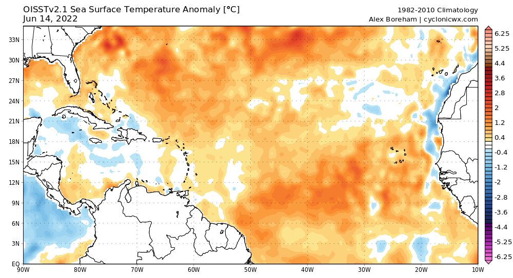
From what I am seeing, I genuinely think that this season is bound to feature at least several major land impacts unfortunately. With so many models insistent on a wetter Caribbean (and where storms that trek through that region of the Atlantic typically end up hitting land inevitably at some point thanks to the geography), it would be a rather major miracle if by the end of this season the Caribbean-bordering islands and regions are spared. As for the CONUS, I'm still a bit uncertain as to how bad this season will be in the end, but given the La Nina and higher chance of seeing Caribbean tracking storms, I feel that the Gulf may be a place to watch, especially if these storms curve northward due to troughing in that region. A 2010 redux at this point imho is rather unlikely to happen, although that of course would be much welcomed considering the blitzkrieg of devastating storms from the past 6 consecutive years.
0 likes   
Unless explicitly stated, all info in my posts is based on my own opinions and observations. Tropical storms and hurricanes can be extremely dangerous. Do not think you can beat Mother Nature. Refer to an accredited weather research agency or meteorologist if you need to make serious decisions regarding an approaching storm.

User avatar
SFLcane
S2K Supporter
S2K Supporter
Posts: 10163
Age: 47
Joined: Sat Jun 05, 2010 1:44 pm
Location: Lake Worth Florida

2022 Global Model Runs Discussion (Out thru day 16)

#1220 Postby SFLcane » Thu Jun 16, 2022 8:51 am

One of them take Frances/Irma type track towards South Florida. Long range CFS so use with extreme caution but the fact its showing wave after wave trying to develop is a good sign a few make could surely make it west.

Image

Image

Image

Image
2 likes   


Return to “Talkin' Tropics”

Who is online

Users browsing this forum: Stormybajan and 36 guests