
2022 Global Model Runs Discussion (Out thru day 16)
Moderator: S2k Moderators
Forum rules

The posts in this forum are NOT official forecasts and should not be used as such. They are just the opinion of the poster and may or may not be backed by sound meteorological data. They are NOT endorsed by any professional institution or STORM2K. For official information, please refer to products from the National Hurricane Center and National Weather Service.
-
skyline385

- Category 5

- Posts: 2728
- Age: 35
- Joined: Wed Aug 26, 2020 11:15 pm
- Location: Houston TX
Re: 2022 Global Model Runs Discussion (Out thru day 16)
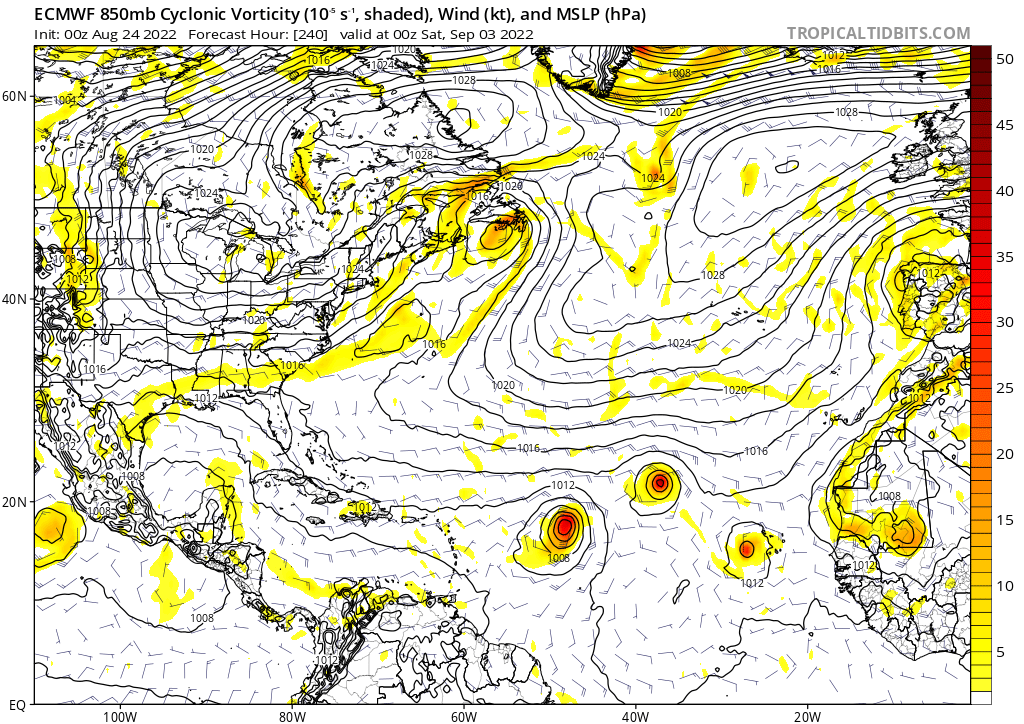
Meanwhile this is the state of the MDR on the GFS 0Z
3 likes

Re: 2022 Global Model Runs Discussion (Out thru day 16)
Teban54 wrote:0z ICON suddenly has 3 TCs in the MDR at the end of its run (180 hours), plus the SA system. It also continues the trend of every model being enthusiastic about the 8/30 wave as a TS right after exiting Africa, which is now almost within a week.
0z Euro continues to have the 8/30 wave emerge as a TS, and this time seems to have a TD inside Africa. 0z GFS also develops it quickly off the coast, though doesn't intensify further from there.
Maybe third time is the charm?
0 likes
TC naming lists: retirements and intensity
Most aggressive Advisory #1's in North Atlantic (cr. kevin for starting the list)
Most aggressive Advisory #1's in North Atlantic (cr. kevin for starting the list)
Re: 2022 Global Model Runs Discussion (Out thru day 16)
Lol
0 likes
TC naming lists: retirements and intensity
Most aggressive Advisory #1's in North Atlantic (cr. kevin for starting the list)
Most aggressive Advisory #1's in North Atlantic (cr. kevin for starting the list)
-
REDHurricane

- Category 1

- Posts: 438
- Age: 28
- Joined: Sun Jul 03, 2022 2:36 pm
- Location: Northeast Pacific Ocean
Re: 2022 Global Model Runs Discussion (Out thru day 16)
Teban54 wrote:Lol
https://i.postimg.cc/15RNM23n/ec-fast-uv850-vort-atl-11.png
Imagine if zero hurricanes develop out of these waves within the next two weeks...
0 likes
-
skyline385
- Category 5
- Posts: 2728
- Age: 35
- Joined: Wed Aug 26, 2020 11:15 pm
- Location: Houston TX
Re: RE: Re: 2022 Global Model Runs Discussion (Out thru day 16)
I think MDR is to the Euro like the Caribbean is to the GFS. It has busted there so many times already this season...Teban54 wrote:Lol
Sent from my LM-V405 using Tapatalk
2 likes

Re: 2022 Global Model Runs Discussion (Out thru day 16)
GFS illustrates a big reason the waves have failed to develop so far--aside from the latitude problem, they're coming off far too broad thanks to monsoon trough interaction. Compare the current wave to the next one, how much tighter the latter is:


1 likes
The above post is not official and should not be used as such. It is the opinion of the poster and may or may not be backed by sound meteorological data. It is not endorsed by any professional institution or storm2k.org. For official information, please refer to the NHC and NWS products.

Re: 2022 Global Model Runs Discussion (Out thru day 16)
What's that feature in the central Gulf on 8/27 on the GFS?
0 likes
Personal Forecast Disclaimer:
The posts in this forum are NOT official forecast and should not be used as such. They are just the opinion of the poster and may or may not be backed by sound meteorological data. They are NOT endorsed by any professional institution or storm2k.org. For official information, please refer to the NHC and NWS products.
The posts in this forum are NOT official forecast and should not be used as such. They are just the opinion of the poster and may or may not be backed by sound meteorological data. They are NOT endorsed by any professional institution or storm2k.org. For official information, please refer to the NHC and NWS products.
-
skyline385
- Category 5
- Posts: 2728
- Age: 35
- Joined: Wed Aug 26, 2020 11:15 pm
- Location: Houston TX
Re: 2022 Global Model Runs Discussion (Out thru day 16)
SoupBone wrote:What's that feature in the central Gulf on 8/27 on the GFS?
Possibly a weak wave i am guessing, it was there on the CMC last night too
Sent from my iPhone using Tapatalk
2 likes
-
AutoPenalti
- Category 5
- Posts: 4091
- Age: 29
- Joined: Mon Aug 17, 2015 4:16 pm
- Location: Ft. Lauderdale, Florida
Re: 2022 Global Model Runs Discussion (Out thru day 16)
Looks like GFS develops something immediately after coming off Africa and moves NW.
0 likes
The posts in this forum are NOT official forecasts and should not be used as such. They are just the opinion of the poster and may or may not be backed by sound meteorological data. They are NOT endorsed by any professional institution or STORM2K. For official information, please refer to products from the NHC and NWS.
Model Runs Cheat Sheet:
GFS (5:30 AM/PM, 11:30 AM/PM)
HWRF, GFDL, UKMET, NAVGEM (6:30-8:00 AM/PM, 12:30-2:00 AM/PM)
ECMWF (1:45 AM/PM)
TCVN is a weighted averaged
-
Iceresistance

- Category 5
- Posts: 9583
- Age: 22
- Joined: Sat Oct 10, 2020 9:45 am
- Location: Tecumseh, OK/Norman, OK
Re: 2022 Global Model Runs Discussion (Out thru day 16)
AutoPenalti wrote:Looks like GFS develops something immediately after coming off Africa and moves NW.
And over the CV as a Hurricane, this has happened once before. (Hurricane Fred in 2015)
0 likes
Bill 2015 & Beta 2020
Winter 2020-2021
All observations are in Tecumseh, OK unless otherwise noted.
Winter posts are focused mainly for Oklahoma & Texas.
Take any of my forecasts with a grain of salt, refer to the NWS, SPC, and NHC for official information
Never say Never with weather! Because ANYTHING is possible!
Winter 2020-2021
All observations are in Tecumseh, OK unless otherwise noted.
Winter posts are focused mainly for Oklahoma & Texas.
Take any of my forecasts with a grain of salt, refer to the NWS, SPC, and NHC for official information
Never say Never with weather! Because ANYTHING is possible!

Re: 2022 Global Model Runs Discussion (Out thru day 16)
Here's something new on the 12Z UKMET at hour 138 in the far eastern MDR: it is shown as 994 mb, which makes it highly questionable since it is ridiculously strong for being just off Africa. It is moving WNW at a pretty high latitude. That in combination with its supposed strength would mean high chance of a very early recurve if it is real:
MET OFFICE TROPICAL CYCLONE GUIDANCE FOR NORTH-EAST PACIFIC AND ATLANTIC
GLOBAL MODEL DATA TIME 1200UTC 24.08.2022
NEW TROPICAL CYCLONE FORECAST TO DEVELOP AFTER 138 HOURS
FORECAST POSITION AT T+138 : 17.5N 16.1W
LEAD CENTRAL MAXIMUM WIND
VERIFYING TIME TIME POSITION PRESSURE (MB) SPEED (KNOTS)
-------------- ---- -------- ------------- -------------
1200UTC 30.08.2022 144 18.4N 17.6W 994 44
Last edited by LarryWx on Wed Aug 24, 2022 11:24 am, edited 2 times in total.
0 likes
Personal Forecast Disclaimer:
The posts in this forum are NOT official forecasts and should not be used as such. They are just the opinion of the poster and may or may not be backed by sound meteorological data. They are NOT endorsed by any professional institution or storm2k.org. For official information, please refer to the NHC and NWS products.
The posts in this forum are NOT official forecasts and should not be used as such. They are just the opinion of the poster and may or may not be backed by sound meteorological data. They are NOT endorsed by any professional institution or storm2k.org. For official information, please refer to the NHC and NWS products.

Re: 2022 Global Model Runs Discussion (Out thru day 16)
SoupBone wrote:What's that feature in the central Gulf on 8/27 on the GFS?
Look at what’s currently in the NW Caribbean. That’s probably what it’s showing.
2 likes
-
skyline385
- Category 5
- Posts: 2728
- Age: 35
- Joined: Wed Aug 26, 2020 11:15 pm
- Location: Houston TX
Re: 2022 Global Model Runs Discussion (Out thru day 16)
AutoPenalti wrote:Looks like GFS develops something immediately after coming off Africa and moves NW.
ICON has it too but it also has two other systems near it fighting
Sent from my iPhone using Tapatalk
0 likes
-
AutoPenalti
- Category 5
- Posts: 4091
- Age: 29
- Joined: Mon Aug 17, 2015 4:16 pm
- Location: Ft. Lauderdale, Florida
Re: 2022 Global Model Runs Discussion (Out thru day 16)
This looks very much OTS

0 likes
The posts in this forum are NOT official forecasts and should not be used as such. They are just the opinion of the poster and may or may not be backed by sound meteorological data. They are NOT endorsed by any professional institution or STORM2K. For official information, please refer to products from the NHC and NWS.
Model Runs Cheat Sheet:
GFS (5:30 AM/PM, 11:30 AM/PM)
HWRF, GFDL, UKMET, NAVGEM (6:30-8:00 AM/PM, 12:30-2:00 AM/PM)
ECMWF (1:45 AM/PM)
TCVN is a weighted averaged
Re: 2022 Global Model Runs Discussion (Out thru day 16)
AutoPenalti wrote:Looks like GFS develops something immediately after coming off Africa and moves NW.
12Z UKMET, which I just posted, has something similar in location, timing, strength, and movement (WNW) fwiw.
0 likes
Personal Forecast Disclaimer:
The posts in this forum are NOT official forecasts and should not be used as such. They are just the opinion of the poster and may or may not be backed by sound meteorological data. They are NOT endorsed by any professional institution or storm2k.org. For official information, please refer to the NHC and NWS products.
The posts in this forum are NOT official forecasts and should not be used as such. They are just the opinion of the poster and may or may not be backed by sound meteorological data. They are NOT endorsed by any professional institution or storm2k.org. For official information, please refer to the NHC and NWS products.
-
AutoPenalti
- Category 5
- Posts: 4091
- Age: 29
- Joined: Mon Aug 17, 2015 4:16 pm
- Location: Ft. Lauderdale, Florida
Re: 2022 Global Model Runs Discussion (Out thru day 16)
Uhh... nevermind. Cutoff low just disappears. Very early Irma-ish track.

0 likes
The posts in this forum are NOT official forecasts and should not be used as such. They are just the opinion of the poster and may or may not be backed by sound meteorological data. They are NOT endorsed by any professional institution or STORM2K. For official information, please refer to products from the NHC and NWS.
Model Runs Cheat Sheet:
GFS (5:30 AM/PM, 11:30 AM/PM)
HWRF, GFDL, UKMET, NAVGEM (6:30-8:00 AM/PM, 12:30-2:00 AM/PM)
ECMWF (1:45 AM/PM)
TCVN is a weighted averaged

Re: 2022 Global Model Runs Discussion (Out thru day 16)
I think we should just ignore whatever the CMC is saying. It keeps trying to form a CAG in about a week or so, which shouldn’t be possible for late August/early September.
0 likes
Irene '11 Sandy '12 Hermine '16 5/15/2018 Derecho Fay '20 Isaias '20 Elsa '21 Henri '21 Ida '21
I am only a meteorology enthusiast who knows a decent amount about tropical cyclones. Look to the professional mets, the NHC, or your local weather office for the best information.
I am only a meteorology enthusiast who knows a decent amount about tropical cyclones. Look to the professional mets, the NHC, or your local weather office for the best information.
Re: 2022 Global Model Runs Discussion (Out thru day 16)
LarryWx wrote:Here's something new on the 12Z UKMET at hour 138 in the far eastern MDR: it is shown as 994 mb, which makes it highly questionable since it is ridiculously strong for being just off Africa. It is moving WNW at a pretty high latitude. That in combination with its supposed strength would mean high chance of a very early recurve if it is real:
MET OFFICE TROPICAL CYCLONE GUIDANCE FOR NORTH-EAST PACIFIC AND ATLANTIC
GLOBAL MODEL DATA TIME 1200UTC 24.08.2022
NEW TROPICAL CYCLONE FORECAST TO DEVELOP AFTER 138 HOURS
FORECAST POSITION AT T+138 : 17.5N 16.1W
LEAD CENTRAL MAXIMUM WIND
VERIFYING TIME TIME POSITION PRESSURE (MB) SPEED (KNOTS)
-------------- ---- -------- ------------- -------------
1200UTC 30.08.2022 144 18.4N 17.6W 994 44
This is the 8/30 wave that GFS, Euro and ICON have all been showing as a TD/TS immediately after coming off Africa, run after run. They disagree on intensity at splashdown and evolution in the MDR, of course.
If anything, now that the conservative UKMET is jumping on board, it gives even more credence that it may be real and not just a model cane like the two waves before it. The time frame is now within a week, too.
FWIW, Irma formed around a similar time frame, after every single wave before it struggled due to SAL.
0 likes
TC naming lists: retirements and intensity
Most aggressive Advisory #1's in North Atlantic (cr. kevin for starting the list)
Most aggressive Advisory #1's in North Atlantic (cr. kevin for starting the list)
-
AutoPenalti
- Category 5
- Posts: 4091
- Age: 29
- Joined: Mon Aug 17, 2015 4:16 pm
- Location: Ft. Lauderdale, Florida
Re: 2022 Global Model Runs Discussion (Out thru day 16)
Moving WNW into a weakness but trough is lifting away…
0 likes
The posts in this forum are NOT official forecasts and should not be used as such. They are just the opinion of the poster and may or may not be backed by sound meteorological data. They are NOT endorsed by any professional institution or STORM2K. For official information, please refer to products from the NHC and NWS.
Model Runs Cheat Sheet:
GFS (5:30 AM/PM, 11:30 AM/PM)
HWRF, GFDL, UKMET, NAVGEM (6:30-8:00 AM/PM, 12:30-2:00 AM/PM)
ECMWF (1:45 AM/PM)
TCVN is a weighted averaged
-
skyline385
- Category 5
- Posts: 2728
- Age: 35
- Joined: Wed Aug 26, 2020 11:15 pm
- Location: Houston TX
Re: 2022 Global Model Runs Discussion (Out thru day 16)
We have seen plenty of systems like this one in the past few weeks but they disappear off in a few runs out. Let’s see if this one is any different but am not holding my breath…
Sent from my iPhone using Tapatalk
Sent from my iPhone using Tapatalk
0 likes
Who is online
Users browsing this forum: No registered users and 45 guests