Low Pressure in the Central Atlantic (Is Invest 91L)

This is the general tropical discussion area. Anyone can take their shot at predicting a storms path.

Moderator: S2k Moderators

Forum rules

The posts in this forum are NOT official forecasts and should not be used as such. They are just the opinion of the poster and may or may not be backed by sound meteorological data. They are NOT endorsed by any professional institution or STORM2K. For official information, please refer to products from the National Hurricane Center and National Weather Service.

Help Support Storm2K
Message
Author
sma10
Category 5
Category 5
Posts: 1710
Joined: Tue Aug 02, 2005 1:13 pm

Re: Tropical Wave SW of the Cabo Verde Islands

#341 Postby sma10 » Fri Aug 26, 2022 9:53 pm

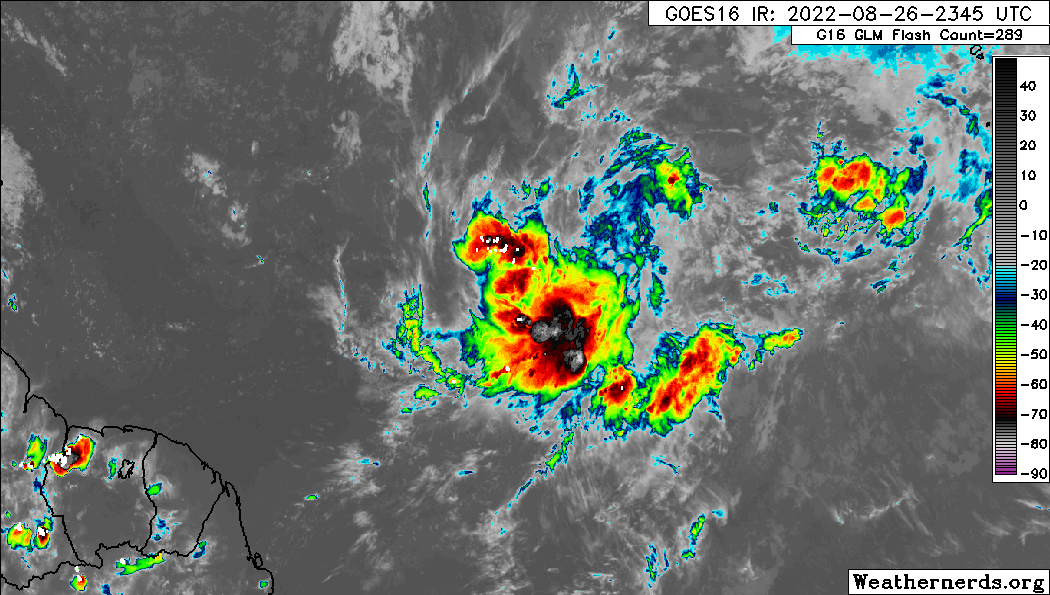
NXStumpy_Robothing wrote:I don't understand why we continue to be so reactionary on here with regards to this wave; this interaction between the two lobes was well-forecasted in advance by most modeling solutions and illustrates that we are still 2-3 days away from TCG, again in line with modeling. We're going to need to wait until after these two competing vortmaxes within the larger monsoon trough determine a victor or find a way to combine their vorticity before we can expect there to be a TC. See Isaias's genesis from 2020 for a similar example.

Even now, new convection is firing over the well-defined mid-level spin which is very close to closing off at the surface. I don't see a reason to worry unless it stays anemic through dmax (which looks unlikely). I'd also be very surprised (given the near-universal model consensus for TCG within the next week) for this to not develop at this point.

Just another situation where you have to monitor what's happening with short-term satellite trends and modeling solutions, as is often the case. Going to be an interesting few days with this wave regardless.


Agreed, don't quite understand the reactions either. Euro has been extremely consistent in not developing this system until it has time to wobble around each other and loop-di-loop.

You'd think the fact that since it is actually following the Euro design that people would be MORE confident in its solution?
2 likes   

User avatar
Hammy
Category 5
Category 5
Posts: 5849
Age: 41
Joined: Fri May 25, 2012 5:25 pm
Contact:

Re: Tropical Wave SW of the Cabo Verde Islands

#342 Postby Hammy » Fri Aug 26, 2022 9:56 pm


A lot more organized at the surface than I realized. I expected there'd be no east winds south of 13-14N
1 likes   
The above post is not official and should not be used as such. It is the opinion of the poster and may or may not be backed by sound meteorological data. It is not endorsed by any professional institution or storm2k.org. For official information, please refer to the NHC and NWS products.

User avatar
Hurricaneman
Category 5
Category 5
Posts: 7349
Age: 44
Joined: Tue Aug 31, 2004 3:24 pm
Location: central florida

Re: Tropical Wave SW of the Cabo Verde Islands

#343 Postby Hurricaneman » Fri Aug 26, 2022 10:06 pm

Seems as though we’re coming out of D-min and convection is firing again around the possible center, could close it off if it isn’t already
0 likes   

User avatar
SFLcane
S2K Supporter
S2K Supporter
Posts: 10162
Age: 47
Joined: Sat Jun 05, 2010 1:44 pm
Location: Lake Worth Florida

Re: Tropical Wave SW of the Cabo Verde Islands

#344 Postby SFLcane » Fri Aug 26, 2022 10:09 pm

Hurricaneman wrote:Seems as though we’re coming out of D-min and convection is firing again around the possible center, could close it off if it isn’t already


Yea was about to comment on this. Convection once again firing with decent amount of lighting.

Image
0 likes   

User avatar
chaser1
S2K Supporter
S2K Supporter
Posts: 5407
Age: 64
Joined: Sat Oct 15, 2005 5:59 pm
Location: Longwood, Fl

Re: Tropical Wave SW of the Cabo Verde Islands

#345 Postby chaser1 » Fri Aug 26, 2022 10:13 pm

Certainly seeing plenty of turning just not all in one place. Thats not a knock against development but rather a bigger question mark regarding (potential) eventual track. Especially now, trust the trend not the models
2 likes   
Andy D

(For official information, please refer to the NHC and NWS products.)

tolakram
Admin
Admin
Posts: 19990
Age: 61
Joined: Sun Aug 27, 2006 8:23 pm
Location: Florence, KY (name is Mark)

Re: Tropical Wave SW of the Cabo Verde Islands

#346 Postby tolakram » Fri Aug 26, 2022 10:18 pm

0 likes   
M a r k
- - - - -
Join us in chat: Storm2K Chatroom Invite. Android and IOS apps also available.

The posts in this forum are NOT official forecasts and should not be used as such. Posts are NOT endorsed by any professional institution or STORM2K.org. For official information and forecasts, please refer to NHC and NWS products.

User avatar
Category5Kaiju
Category 5
Category 5
Posts: 4052
Joined: Thu Dec 24, 2020 12:45 pm
Location: Seattle

Re: Tropical Wave SW of the Cabo Verde Islands

#347 Postby Category5Kaiju » Fri Aug 26, 2022 10:21 pm

The fact that this system is at a decently low latitude with warm ssts below it and shielded away from all of the dry air to the north is really doing it favors, isn't it? :lol:
4 likes   
Unless explicitly stated, all info in my posts is based on my own opinions and observations. Tropical storms and hurricanes can be extremely dangerous. Do not think you can beat Mother Nature. Refer to an accredited weather research agency or meteorologist if you need to make serious decisions regarding an approaching storm.

Sciencerocks
Category 5
Category 5
Posts: 8903
Age: 39
Joined: Thu Jul 06, 2017 1:51 am

Re: Tropical Wave SW of the Cabo Verde Islands

#348 Postby Sciencerocks » Fri Aug 26, 2022 10:44 pm

Image
2 likes   

User avatar
skyline385
Category 5
Category 5
Posts: 2728
Age: 34
Joined: Wed Aug 26, 2020 11:15 pm
Location: Houston TX

Re: Tropical Wave SW of the Cabo Verde Islands

#349 Postby skyline385 » Fri Aug 26, 2022 10:52 pm

ICON 0Z ends at a 965mb which is pretty high considering the model's typically very conservative runs.

Image
0 likes   

caneseddy
Category 5
Category 5
Posts: 1172
Joined: Fri Sep 03, 2004 9:31 pm
Location: Plantation, FL

Re: Tropical Wave SW of the Cabo Verde Islands

#350 Postby caneseddy » Fri Aug 26, 2022 11:03 pm

skyline385 wrote:ICON 0Z ends at a 965mb which is pretty high considering the model's typically very conservative runs.

https://s4.gifyu.com/images/icon_mslp_pcpn_atl_fh120-180.gif


That’s very low pressure for Icon to show. Also you can see at the end of the run what looks to be the beginning of a turn to the west north of the islands..
Last edited by caneseddy on Fri Aug 26, 2022 11:05 pm, edited 1 time in total.
0 likes   

User avatar
chaser1
S2K Supporter
S2K Supporter
Posts: 5407
Age: 64
Joined: Sat Oct 15, 2005 5:59 pm
Location: Longwood, Fl

Re: Tropical Wave SW of the Cabo Verde Islands

#351 Postby chaser1 » Fri Aug 26, 2022 11:04 pm

Category5Kaiju wrote:The fact that this system is at a decently low latitude with warm ssts below it and shielded away from all of the dry air to the north is really doing it favors, isn't it? :lol:


To our eyes? Perhaps not. Unless of course this diurnal dance is merely "Mayhem" giving us the finger while picking HER spot :cheesy:
0 likes   
Andy D

(For official information, please refer to the NHC and NWS products.)

User avatar
Hybridstorm_November2001
S2K Supporter
S2K Supporter
Posts: 2811
Joined: Sat Aug 21, 2004 2:50 pm
Location: SW New Brunswick, Canada
Contact:

Re: Tropical Wave SW of the Cabo Verde Islands

#352 Postby Hybridstorm_November2001 » Fri Aug 26, 2022 11:32 pm

Thankfully, I'm skeptical the Icon will verify given the current environmental conditions.
0 likes   

User avatar
skyline385
Category 5
Category 5
Posts: 2728
Age: 34
Joined: Wed Aug 26, 2020 11:15 pm
Location: Houston TX

Re: Tropical Wave SW of the Cabo Verde Islands

#353 Postby skyline385 » Fri Aug 26, 2022 11:33 pm

0Z GFS run very weak at 165 hrs, not even a TS but its probably because of the gulf cane
Last edited by skyline385 on Fri Aug 26, 2022 11:36 pm, edited 1 time in total.
0 likes   

sma10
Category 5
Category 5
Posts: 1710
Joined: Tue Aug 02, 2005 1:13 pm

Re: Tropical Wave SW of the Cabo Verde Islands

#354 Postby sma10 » Fri Aug 26, 2022 11:36 pm

Hybridstorm_November2001 wrote:Thankfully, I'm skeptical the Icon will verify given the current environmental conditions.


ICON doesn't really do anything with the system for the next 4.5 days. All the strengthening occurs way down the road
0 likes   

User avatar
Hurricaneman
Category 5
Category 5
Posts: 7349
Age: 44
Joined: Tue Aug 31, 2004 3:24 pm
Location: central florida

Re: Tropical Wave SW of the Cabo Verde Islands

#355 Postby Hurricaneman » Fri Aug 26, 2022 11:45 pm

skyline385 wrote:0Z GFS run very weak at 165 hrs, not even a TS but its probably because of the gulf cane


Still slightly stronger than the 18z but could be trending towards the Euro in track so this could still be a problem especially if the GFS is underestimating the longer term like it did several times in the past
0 likes   

LarryWx
Category 5
Category 5
Posts: 6246
Joined: Sun Sep 07, 2003 2:04 pm
Location: GA

Re: Tropical Wave SW of the Cabo Verde Islands

#356 Postby LarryWx » Sat Aug 27, 2022 12:04 am

0Z UKMET: forms 12 hours earlier and 100 miles south of the 12Z along with a left turn toward more westerly late vs the 12Z showing more WNW to NW move late. Similar to the 12Z, it remains a TD:

NEW TROPICAL CYCLONE FORECAST TO DEVELOP AFTER 84 HOURS
FORECAST POSITION AT T+ 84 : 12.4N 45.9W

LEAD CENTRAL MAXIMUM WIND
VERIFYING TIME TIME POSITION PRESSURE (MB) SPEED (KNOTS)
-------------- ---- -------- ------------- -------------
1200UTC 30.08.2022 84 12.4N 45.9W 1009 28
0000UTC 31.08.2022 96 12.4N 46.2W 1008 27
1200UTC 31.08.2022 108 13.8N 46.8W 1008 30
0000UTC 01.09.2022 120 15.0N 48.7W 1007 30
1200UTC 01.09.2022 132 15.8N 50.6W 1006 31
0000UTC 02.09.2022 144 16.1N 52.7W 1004 29
0 likes   
Personal Forecast Disclaimer:
The posts in this forum are NOT official forecasts and should not be used as such. They are just the opinion of the poster and may or may not be backed by sound meteorological data. They are NOT endorsed by any professional institution or storm2k.org. For official information, please refer to the NHC and NWS products.

Fancy1001
Category 1
Category 1
Posts: 452
Joined: Thu Jul 16, 2020 10:16 pm

Re: Tropical Wave SW of the Cabo Verde Islands

#357 Postby Fancy1001 » Sat Aug 27, 2022 12:07 am

I’m just curious whether this forms officially on August 31 or September 1
0 likes   

User avatar
Hammy
Category 5
Category 5
Posts: 5849
Age: 41
Joined: Fri May 25, 2012 5:25 pm
Contact:

Re: Tropical Wave SW of the Cabo Verde Islands

#358 Postby Hammy » Sat Aug 27, 2022 12:20 am

Canadian has development, meanwhile GFS doesn't. GFS really struggling with the monsoon trough setup here
0 likes   
The above post is not official and should not be used as such. It is the opinion of the poster and may or may not be backed by sound meteorological data. It is not endorsed by any professional institution or storm2k.org. For official information, please refer to the NHC and NWS products.

User avatar
Hybridstorm_November2001
S2K Supporter
S2K Supporter
Posts: 2811
Joined: Sat Aug 21, 2004 2:50 pm
Location: SW New Brunswick, Canada
Contact:

Re: Tropical Wave SW of the Cabo Verde Islands

#359 Postby Hybridstorm_November2001 » Sat Aug 27, 2022 12:36 am

sma10 wrote:
Hybridstorm_November2001 wrote:Thankfully, I'm skeptical the Icon will verify given the current environmental conditions.


ICON doesn't really do anything with the system for the next 4.5 days. All the strengthening occurs way down the road


I'll be surprised if by then the Atlantic has become significantly less hostile so as to allow such a scenario. The trend is your friend, thus far this season the Basin has been extremely hostile to TCs, luckily. :spam:
0 likes   

User avatar
skyline385
Category 5
Category 5
Posts: 2728
Age: 34
Joined: Wed Aug 26, 2020 11:15 pm
Location: Houston TX

Re: Tropical Wave SW of the Cabo Verde Islands

#360 Postby skyline385 » Sat Aug 27, 2022 1:11 am

0Z ECMWF starts off very strong but then suddenly seems to weaken around 60 hours into a broad circulation :?:
0 likes   


Return to “Talkin' Tropics”

Who is online

Users browsing this forum: KeysRedWine and 202 guests