
ATL: FIONA - Post-Tropical - Discussion
Moderator: S2k Moderators
-
tolakram
- Admin

- Posts: 20186
- Age: 62
- Joined: Sun Aug 27, 2006 8:23 pm
- Location: Florence, KY (name is Mark)
Re: ATL: INVEST 96L - Discussion
saved loop
8 likes
M a r k
- - - - -
Join us in chat: Storm2K Chatroom Invite. Android and IOS apps also available.
The posts in this forum are NOT official forecasts and should not be used as such. Posts are NOT endorsed by any professional institution or STORM2K.org. For official information and forecasts, please refer to NHC and NWS products.

Re: ATL: INVEST 96L - Discussion
I thought the season was over? 
1 likes
TC naming lists: retirements and intensity
Most aggressive Advisory #1's in North Atlantic (cr. kevin for starting the list)
Most aggressive Advisory #1's in North Atlantic (cr. kevin for starting the list)
-
toad strangler

- S2K Supporter

- Posts: 4546
- Joined: Sun Jul 28, 2013 3:09 pm
- Location: Earth
- Contact:
Re: ATL: INVEST 96L - Models
boca wrote:It’s probably going to curve over the Bahamas or just east of it and miss Florida my opinion.The TUTT will most likely cause the weakness and like I said earlier in the year that it’s rare to get hit from the east.
Well, no it actually isn't as I posted in rebuttal with actual dates of strikes from the East later than today's date. I guessed you missed that? I mean strikes in any one area are tough to begin with no matter the date. Anyway, I think it's prudent to just watch this until we see what happens with any GA interaction. Most likely outcome would be a re-curve if this system stacks up somewhat.
Edit .... here is the list. Nine strikes from the E later than today's date. Once every 19-20 years on average since 1850. But, we know the tropics don't care about silly averages.
9/15/1945 Cat 4 Miami Dade
9/16/1947 Cat 4 Broward
9/17/1928 Cat 4 Palm Beach
9/18/1926 Cat 4 Miami/Dade
9/26/2005 Cat 3 Martin
10/6/1941 Cat 2 Miami/Dade
10/17/1904 Cat 1 Miami/Dade
10/18/1950 Cat 4 Miami/Dade
11/4/1935 Cat 2 Miami/Dade
1 likes
My Weather Station
https://www.wunderground.com/dashboard/pws/KFLPORTS603
https://www.wunderground.com/dashboard/pws/KFLPORTS603

Re: ATL: INVEST 96L - Discussion
There is a "relative" closed circulation but WXman57 is right we should not ignore the clinging effect a trough axis has on a developing low.
So maybe 00Z HWRF overdid on intensity, but we don't want this to miss a TUTT because the track is too far south..
So maybe 00Z HWRF overdid on intensity, but we don't want this to miss a TUTT because the track is too far south..
0 likes

Re: ATL: INVEST 96L - Discussion
weird season, the last two decades I would have been watching this like a hawk here in Central Florida but it seems to be either going south of us as a weaker storm or north of us if gets stronger, we are usually in the crosshairs of a storm like this, at least in the first few models but not so much this time....hoping for a strong fish just to get those ACE numbers up, US economy really doesn't need a strong storm hitting anywhere right now and causing more damage and delays
0 likes
Just like Jon Snow..."I know nothing" except what I know, and most of what I know is gathered by the fine people of the NHC
Re: ATL: INVEST 96L - Discussion
jlauderdal wrote:skyline385 wrote:jlauderdal wrote:it seems to be overachieving, Are you sure a stronger storm makes it into the carib?
There is a ridge building up above it so a stronger storm may still end up in the Caribbean
https://i.imgur.com/i0g3dzV.png
On the GFS there is a ridge, the euro says bye-bye to the ridge and the system heads towards the NNE. Very interesting setup with a fork in the road around the shredder. Let the arguments, conjecture and in some cases, pure fantasy proceed.
Real tricky one here. Clearly, the models suggest that anything that develops to any significant strength prior to the Caribbean or in the vicinity of PR or DR will pull northward and away. However ... the models are also of the opinion that a weak, sloppy mess could get drawn pretty far westward into a completely different environment. Definite "fork in the road" scenario shaping up
0 likes
-
Iceresistance

- Category 5

- Posts: 9591
- Age: 22
- Joined: Sat Oct 10, 2020 9:45 am
- Location: Tecumseh, OK/Norman, OK
Re: ATL: INVEST 96L - Discussion
70%
1. Central Tropical Atlantic:
Showers and thunderstorms associated with a broad and elongated
area of low pressure located about 800 miles east of the Lesser
Antilles have persisted overnight and are showing signs of
organization. Although upper-level winds are not particularly
conducive for additional development, only a slight increase in
organization would result in the formation of a tropical
depression. The system is forecast to move generally westward
over the tropical Atlantic during the next day or so, and move
near or over portions of the Leeward Islands Friday and Friday
night. Regardless of development, the system is likely to bring
gusty winds and locally heavy rainfall to portions of the Leeward
Islands Friday through Saturday. Interests in the Leeward Islands,
the Virgin Islands, and Puerto Rico should monitor the progress of
this system.
* Formation chance through 48 hours...high...70 percent.
* Formation chance through 5 days...high...70 percent.
Forecaster Brown
0 likes
Bill 2015 & Beta 2020
Winter 2020-2021
All observations are in Tecumseh, OK unless otherwise noted.
Winter posts are focused mainly for Oklahoma & Texas.
Take any of my forecasts with a grain of salt, refer to the NWS, SPC, and NHC for official information
Never say Never with weather! Because ANYTHING is possible!
Winter 2020-2021
All observations are in Tecumseh, OK unless otherwise noted.
Winter posts are focused mainly for Oklahoma & Texas.
Take any of my forecasts with a grain of salt, refer to the NWS, SPC, and NHC for official information
Never say Never with weather! Because ANYTHING is possible!
-
SFLcane

- S2K Supporter
- Posts: 10281
- Age: 48
- Joined: Sat Jun 05, 2010 1:44 pm
- Location: Lake Worth Florida
Re: ATL: INVEST 96L - Discussion
Should have no problem recurving out to sea or again near bermuda.
https://twitter.com/JackSillin/status/1570049476106276869
https://twitter.com/JackSillin/status/1570049476106276869
1 likes

Re: ATL: INVEST 96L - Discussion
SFLcane wrote:Should have no problem recurving out to sea or again near bermuda.
https://twitter.com/JackSillin/status/1570049476106276869?s=20&t=HPOcAdVXGe5HWnrzsQdkrw
Earl part 2
0 likes
-
SFLcane
- S2K Supporter
- Posts: 10281
- Age: 48
- Joined: Sat Jun 05, 2010 1:44 pm
- Location: Lake Worth Florida
Re: ATL: INVEST 96L - Discussion
boca wrote:SFLcane wrote:Should have no problem recurving out to sea or again near bermuda.
https://twitter.com/JackSillin/status/1570049476106276869?s=20&t=HPOcAdVXGe5HWnrzsQdkrw
Earl part 2
Yup!
0 likes
-
AutoPenalti
- Category 5
- Posts: 4091
- Age: 29
- Joined: Mon Aug 17, 2015 4:16 pm
- Location: Ft. Lauderdale, Florida
Re: ATL: INVEST 96L - Discussion
SFLcane wrote:boca wrote:SFLcane wrote:Should have no problem recurving out to sea or again near bermuda.
https://twitter.com/JackSillin/status/1570049476106276869?s=20&t=HPOcAdVXGe5HWnrzsQdkrw
Earl part 2
Yup!
Meh, extreme doubt. This is super progressive especially with it being Typhoon-influenced.
0 likes
The posts in this forum are NOT official forecasts and should not be used as such. They are just the opinion of the poster and may or may not be backed by sound meteorological data. They are NOT endorsed by any professional institution or STORM2K. For official information, please refer to products from the NHC and NWS.
Model Runs Cheat Sheet:
GFS (5:30 AM/PM, 11:30 AM/PM)
HWRF, GFDL, UKMET, NAVGEM (6:30-8:00 AM/PM, 12:30-2:00 AM/PM)
ECMWF (1:45 AM/PM)
TCVN is a weighted averaged
-
SFLcane
- S2K Supporter
- Posts: 10281
- Age: 48
- Joined: Sat Jun 05, 2010 1:44 pm
- Location: Lake Worth Florida
Re: ATL: INVEST 96L - Discussion
AutoPenalti wrote:SFLcane wrote:boca wrote:
Earl part 2
Yup!
Meh, extreme doubt. This is super progressive especially with it being Typhoon-influenced.
0 likes
-
CourierPR

- Category 5
- Posts: 1336
- Age: 72
- Joined: Tue Aug 31, 2004 7:53 pm
- Location: Pompano Beach, Florida
Re: ATL: INVEST 96L - Discussion
Wasn't high pressure expected to build in and steer this west? What happened?
0 likes
-
DorkyMcDorkface

- Category 5
- Posts: 1017
- Age: 28
- Joined: Mon Sep 30, 2019 1:32 pm
- Location: Mid-Atlantic
Re: ATL: INVEST 96L - Discussion

0 likes
Please note the thoughts expressed by this account are solely those of the user and are from a hobbyist perspective. For more comprehensive analysis, consult an actual professional meteorologist or meteorological agency.
Floyd 1999 | Isabel 2003 | Hanna 2008 | Irene 2011 | Sandy 2012 | Isaias 2020
-
DorkyMcDorkface
- Category 5
- Posts: 1017
- Age: 28
- Joined: Mon Sep 30, 2019 1:32 pm
- Location: Mid-Atlantic
Re: ATL: INVEST 96L - Discussion
DorkyMcDorkface wrote:FNMOC has 07L. We'll see if NHC pulls the trigger.
https://cdn.discordapp.com/attachments/733552978572869632/1019618803165954078/Screenshot_4156.png
They do:
https://twitter.com/nhc_atlantic/status/1570060440088219648
0 likes
Please note the thoughts expressed by this account are solely those of the user and are from a hobbyist perspective. For more comprehensive analysis, consult an actual professional meteorologist or meteorological agency.
Floyd 1999 | Isabel 2003 | Hanna 2008 | Irene 2011 | Sandy 2012 | Isaias 2020
-
toad strangler
- S2K Supporter
- Posts: 4546
- Joined: Sun Jul 28, 2013 3:09 pm
- Location: Earth
- Contact:
Re: ATL: INVEST 96L - Discussion
CourierPR wrote:Wasn't high pressure expected to build in and steer this west? What happened?
the 500mb set up being talked about is 6 days out. It's not a good idea to that that verbatim as we have seen countless times before. We shall see.
0 likes
My Weather Station
https://www.wunderground.com/dashboard/pws/KFLPORTS603
https://www.wunderground.com/dashboard/pws/KFLPORTS603
-
AutoPenalti
- Category 5
- Posts: 4091
- Age: 29
- Joined: Mon Aug 17, 2015 4:16 pm
- Location: Ft. Lauderdale, Florida
Re: ATL: INVEST 96L - Discussion
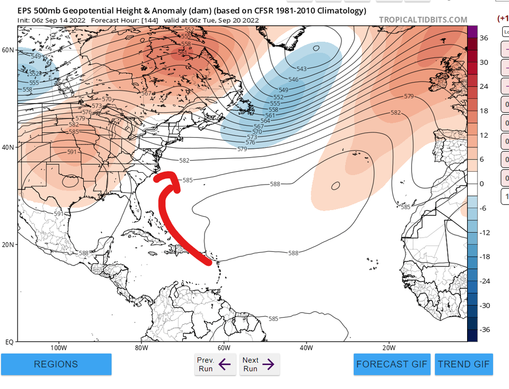
SFLcane wrote:AutoPenalti wrote:SFLcane wrote:
Yup!
Meh, extreme doubt. This is super progressive especially with it being Typhoon-influenced.
https://i.postimg.cc/bYx2ryNr/eps.png
Almost a week out, we shall see.
0 likes
The posts in this forum are NOT official forecasts and should not be used as such. They are just the opinion of the poster and may or may not be backed by sound meteorological data. They are NOT endorsed by any professional institution or STORM2K. For official information, please refer to products from the NHC and NWS.
Model Runs Cheat Sheet:
GFS (5:30 AM/PM, 11:30 AM/PM)
HWRF, GFDL, UKMET, NAVGEM (6:30-8:00 AM/PM, 12:30-2:00 AM/PM)
ECMWF (1:45 AM/PM)
TCVN is a weighted averaged
-
SFLcane
- S2K Supporter
- Posts: 10281
- Age: 48
- Joined: Sat Jun 05, 2010 1:44 pm
- Location: Lake Worth Florida
Re: ATL: SEVEN - Tropical Depression - Discussion
70-70 straight to upgrade this is a first for me.
0 likes
-
InfernoFlameCat

- Category 5
- Posts: 2127
- Age: 22
- Joined: Mon Dec 14, 2020 10:52 am
- Location: Buford, GA
Re: ATL: SEVEN - Tropical Depression - Discussion
2 days ago this wasn't even listed.
2 likes
I am by no means a professional. DO NOT look at my forecasts for official information or make decisions based on what I post.
Goal: to become a registered expert over tropical and subtropical cyclones.
Goal: to become a registered expert over tropical and subtropical cyclones.
-
Sciencerocks
- Category 5
- Posts: 10186
- Age: 40
- Joined: Thu Jul 06, 2017 1:51 am

Who is online
Users browsing this forum: No registered users and 68 guests