ATL: FIONA - Post-Tropical - Discussion
Moderator: S2k Moderators

Re: ATL: FIONA - Tropical Storm - Discussion
We are under a tropical storm watch
5 likes
Too many hurricanes to remember
-
cycloneye

- Admin

- Posts: 149508
- Age: 69
- Joined: Thu Oct 10, 2002 10:54 am
- Location: San Juan, Puerto Rico
Re: ATL: FIONA - Tropical Storm - Discussion
msbee wrote:We are under a tropical storm watch
Hi Barbara. Yes. Stay safe.
4 likes
Visit the Caribbean-Central America Weather Thread where you can find at first post web cams,radars
and observations from Caribbean basin members Click Here
and observations from Caribbean basin members Click Here
-
skyline385

- Category 5

- Posts: 2728
- Age: 35
- Joined: Wed Aug 26, 2020 11:15 pm
- Location: Houston TX
Re: ATL: FIONA - Tropical Storm - Discussion
Cold tops expanding in last few frames although still sheared to the west

4 likes
-
CrazyC83
- Professional-Met

- Posts: 34315
- Joined: Tue Mar 07, 2006 11:57 pm
- Location: Deep South, for the first time!
ATL: FIONA - Models
It's likely all westbound to the Leewards as that ridge is very strong. The way I see it is that if the storm is strong, it will hit that weakness and move northwest at the end of the run, but a weaker storm would just continue along - or south of - the Greater Antilles.
4 likes
Re: ATL: FIONA - Tropical Storm - Discussion
cycloneye wrote:msbee wrote:We are under a tropical storm watch
Hi Barbara. Yes. Stay safe.
Thanks Luis. We will be okay although I am concerned about flooding if we get a lot of rain.
Be careful in PR too.
4 likes
Too many hurricanes to remember
-
Craters
- Category 1

- Posts: 428
- Joined: Sat Aug 24, 2013 2:34 pm
- Location: Alvin, TX (south of Houston)
Re: ATL: SEVEN - Tropical Depression - Discussion
InfernoFlameCat wrote:Blown Away wrote:[url]https://i.postimg.cc/dQ2nH8HL/goes16-vis-swir-07-L-202209142105.gif [/url]
Latest position is @16.9N/51.4W, appears TD7’s LLC is racing W exposed and convection is stuck… Shear must be picking up…
reminds me of earl. I hate shear sometimes
So did Hurricane Nicholas. We on the TX Gulf Coast, on the other hand, really, REALLY liked it -- still do, actually!
0 likes
Nothing that I post here should ever be treated as a forecast or anything resembling one. Please check with your local NWS office or the NHC for forecasts, watches, and warnings.
-
MGC

- S2K Supporter

- Posts: 5940
- Joined: Sun Mar 23, 2003 9:05 pm
- Location: Pass Christian MS, or what is left.
Re: ATL: FIONA - Tropical Storm - Discussion
Impressive convective burst this evening. Will be interesting to see what recon finds tomorrow. Appears to be over preforming today. Islands need to start preps.....MGC
2 likes
-
cheezyWXguy

- Category 5
- Posts: 6282
- Joined: Mon Feb 13, 2006 12:29 am
- Location: Dallas, TX
Re: ATL: FIONA - Tropical Storm - Discussion
Starting to think the center relocation/pulling under the convection may not be so far fetched. It’s hard to make out much detail on low level clouds with night time visible/shortwave, but to me the low level circulation envelope looks pretty stretched east to west.
3 likes

Re: ATL: FIONA - Tropical Storm - Discussion

Low cloud motion, after going back and fourth on the satellite for several minutes. Center looks pretty close to the convection but slightly elongated, but the motion within the circle is hard to detect so the center could also be on the east end of it.
2 likes
The above post is not official and should not be used as such. It is the opinion of the poster and may or may not be backed by sound meteorological data. It is not endorsed by any professional institution or storm2k.org. For official information, please refer to the NHC and NWS products.


Re: ATL: FIONA - Tropical Storm - Discussion
Hammy wrote:https://i.imgur.com/SMZvgZk.png
Low cloud motion, after going back and fourth on the satellite for several minutes. Center looks pretty close to the convection but slightly elongated, but the motion within the circle is hard to detect so the center could also be on the east end of it.
This is almost exactly the same thing I am seeing. Looks like it is closer to 16 than 17 north. Could see some southward track changes in the morning if this persists overnight.
0 likes


Re: ATL: FIONA - Tropical Storm - Discussion
Worth noting that if it does in fact occur, a center relocation down-shear could have fairly significant consequences regarding Fiona’s track down the road. Until we have clarity here, we’re really just taking shots in the dark regarding path past the Lesser Antilles, and given the overall accuracy of the models this season… let’s just say I’m not sold on anything yet. While climo suggests that this will not likely be a CONUS threat, it’s certainly too early to rule it out. Regardless, Fiona appears to be overachieving tonight- we might just end up with a significant storm in the deep tropics this season after all…
1 likes

Re: ATL: FIONA - Tropical Storm - Discussion
SUMMARY OF 200 AM AST...0600 UTC...INFORMATION
----------------------------------------------
LOCATION...16.5N 52.4W
ABOUT 625 MI...1005 KM E OF THE LEEWARD ISLANDS
MAXIMUM SUSTAINED WINDS...50 MPH...85 KM/H
PRESENT MOVEMENT...W OR 270 DEGREES AT 14 MPH...23 KM/H
MINIMUM CENTRAL PRESSURE...1002 MB...29.59 INCHES
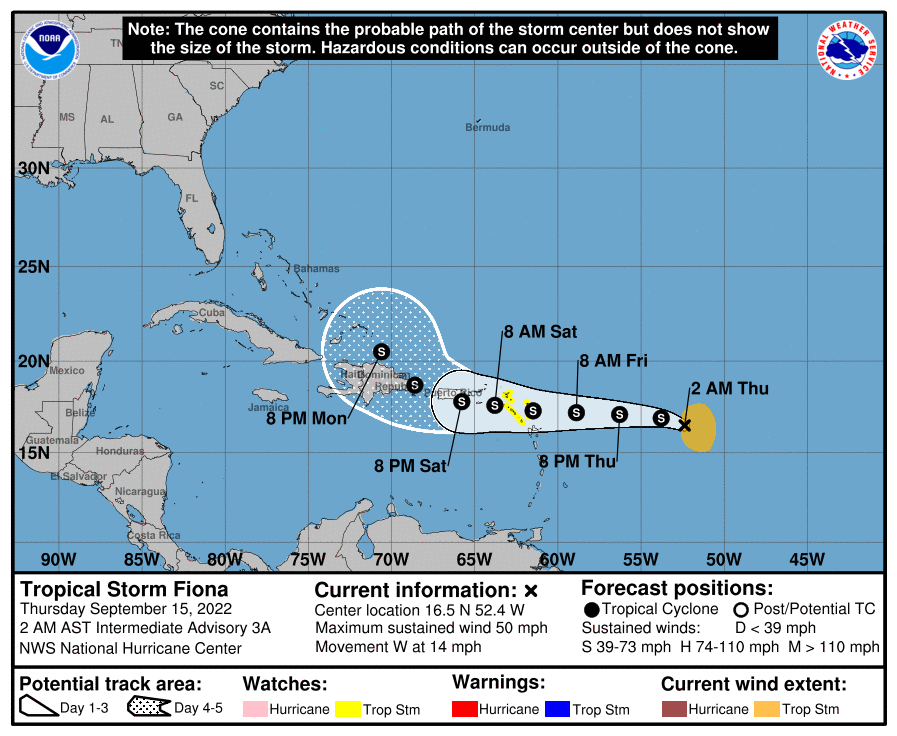
Shifted to the south slightly.
----------------------------------------------
LOCATION...16.5N 52.4W
ABOUT 625 MI...1005 KM E OF THE LEEWARD ISLANDS
MAXIMUM SUSTAINED WINDS...50 MPH...85 KM/H
PRESENT MOVEMENT...W OR 270 DEGREES AT 14 MPH...23 KM/H
MINIMUM CENTRAL PRESSURE...1002 MB...29.59 INCHES
Shifted to the south slightly.
4 likes
-
Sciencerocks
- Category 5
- Posts: 10186
- Age: 40
- Joined: Thu Jul 06, 2017 1:51 am


Re: ATL: FIONA - Tropical Storm - Discussion
Owasso wrote:SUMMARY OF 200 AM AST...0600 UTC...INFORMATION
----------------------------------------------
LOCATION...16.5N 52.4W
ABOUT 625 MI...1005 KM E OF THE LEEWARD ISLANDS
MAXIMUM SUSTAINED WINDS...50 MPH...85 KM/H
PRESENT MOVEMENT...W OR 270 DEGREES AT 14 MPH...23 KM/H
MINIMUM CENTRAL PRESSURE...1002 MB...29.59 INCHES
https://i.postimg.cc/NM7kx96z/D6-AA0097-AA30-46-C9-A70-F-2-E74-AF42-C203.png
Shifted to the south slightly.
Based on the cone it does not seem out of the question that Fiona could pass in between Puerto Rico and DR. In that case the islands could still get a lot of rain/wind, but Fiona's core might remain undisturbed and could thus intensify more than most models show right now.
1 likes

Re: ATL: FIONA - Tropical Storm - Discussion
Going to be interesting to see what the visible shows. Im thinking the LLC is fully exposed east of the convention. Sometimes with weak sheared TS's, a new LLC will form under the convection. The visible will help tremendously to see whats going on.
If you look at BAND 7, it sure looks a swirl east of the convection.
https://www.star.nesdis.noaa.gov/GOES/f ... d=AL072022
If you look at BAND 7, it sure looks a swirl east of the convection.
https://www.star.nesdis.noaa.gov/GOES/f ... d=AL072022
0 likes
-
REDHurricane

- Category 1
- Posts: 438
- Age: 28
- Joined: Sun Jul 03, 2022 2:36 pm
- Location: Northeast Pacific Ocean
Re: ATL: FIONA - Tropical Storm - Discussion
Looks like Fiona is stacking up pretty well up until after the 700mb level, with the 500mb vorticity currently displaced probably around a degree or so to the east due to moderate wind shear present. An upper level anticyclone seems to be allowing for some development right now, though, and both the GFS and Euro are predicting that both shear and anticyclone will track with Fiona for the next 2-3 days or so. After that it appears that the moderate shear will persist and the anticyclone will move down towards the SW Caribbean -- GFS shows Fiona strengthening quickly and splitting off to the north, whereas the Euro shows it staying weaker, moving slowly into Hispaniola around day 4-5, and then kind of stalling for a while as the high pressure to the north is cut into by a trough coming off of New England and thus preventing Fiona from getting pushed further to the west. Right now I'm more inclined to trust the Euro run since conditions will likely remain only semi-favorable for intensification for the next week, and I don't see Fiona becoming a legit high Cat 1-low cat 2 by the end of day 5 like the GFS is forecasting. CMC also predicts a similar track to the Euro if we want to use that as a tiebreaker. But like others have said, this might be one of those storms where we + the models won't have any idea what's going to happen until it actually happens, so essentially nothing is out of the realm of possibility at this point.
925mb vort

850mb vort

700mb vort

500mb vort

200mb vort

GFS 00z out to 7 days
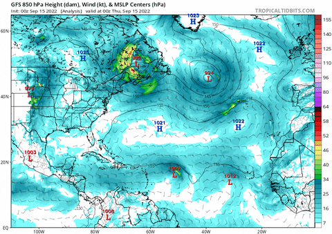
ECMWF 00z out to 7 days
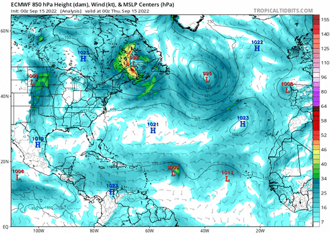
925mb vort
850mb vort
700mb vort
500mb vort
200mb vort
GFS 00z out to 7 days
ECMWF 00z out to 7 days
0 likes
Re: ATL: FIONA - Tropical Storm - Discussion
Kind of getting Hortense 1996 vibes given the location, track, and massive amount of shear that had to deal with about this point.
0 likes
The above post is not official and should not be used as such. It is the opinion of the poster and may or may not be backed by sound meteorological data. It is not endorsed by any professional institution or storm2k.org. For official information, please refer to the NHC and NWS products.
-
Iceresistance

- Category 5
- Posts: 9592
- Age: 22
- Joined: Sat Oct 10, 2020 9:45 am
- Location: Tecumseh, OK/Norman, OK
Re: ATL: FIONA - Tropical Storm - Discussion
Category5Kaiju wrote:Hurricane2022 wrote:I don't think even Shrek believed in a development as fast as this
I can just sniff the "All Star" memes coming if Fiona defies expectations and blows up into a major hurricane

More like "Did Y'all think that I was going to be weak? Think again!"
1 likes
Bill 2015 & Beta 2020
Winter 2020-2021
All observations are in Tecumseh, OK unless otherwise noted.
Winter posts are focused mainly for Oklahoma & Texas.
Take any of my forecasts with a grain of salt, refer to the NWS, SPC, and NHC for official information
Never say Never with weather! Because ANYTHING is possible!
Winter 2020-2021
All observations are in Tecumseh, OK unless otherwise noted.
Winter posts are focused mainly for Oklahoma & Texas.
Take any of my forecasts with a grain of salt, refer to the NWS, SPC, and NHC for official information
Never say Never with weather! Because ANYTHING is possible!

Re: ATL: FIONA - Tropical Storm - Discussion
Convection was sheared south overnight and the low level center was probably almost exposed but getting another updraft burst at sunrise. Shear may have shifted around so its from the NNE now and by the time recon gets there in about 7 hours it may be helping ventilate.
1 likes
-
Blown Away

- S2K Supporter
- Posts: 10253
- Joined: Wed May 26, 2004 6:17 am
Re: ATL: FIONA - Tropical Storm - Discussion

Chugging W, LLC partially exposed but still dragging deep convection on the E side.
1 likes
Hurricane Eye Experience: David 79, Irene 99, Frances 04, Jeanne 04, Wilma 05… Hurricane Brush Experience: Andrew 92, Erin 95, Floyd 99, Matthew 16, Irma 17, Ian 22, Nicole 22…
Who is online
Users browsing this forum: No registered users and 21 guests