ATL: FIONA - Post-Tropical - Discussion
Moderator: S2k Moderators
-
tolakram
- Admin

- Posts: 20186
- Age: 62
- Joined: Sun Aug 27, 2006 8:23 pm
- Location: Florence, KY (name is Mark)
Re: ATL: FIONA - Tropical Storm - Discussion
visible floater https://weather.cod.edu/satrad/?parms=meso-meso1-02-96-1-100-1&checked=map&colorbar=undefined
0 likes
M a r k
- - - - -
Join us in chat: Storm2K Chatroom Invite. Android and IOS apps also available.
The posts in this forum are NOT official forecasts and should not be used as such. Posts are NOT endorsed by any professional institution or STORM2K.org. For official information and forecasts, please refer to NHC and NWS products.
-
tolakram
- Admin
- Posts: 20186
- Age: 62
- Joined: Sun Aug 27, 2006 8:23 pm
- Location: Florence, KY (name is Mark)
Re: ATL: FIONA - Tropical Storm - Discussion
Shear is there, but not getting worse.

source: https://tropic.ssec.wisc.edu/real-time/windmain.php?&basin=atlantic&sat=wg8&prod=shr&zoom=Z&time=
use -3hr, +3hr to see changes, zoom to zoom out
source: https://tropic.ssec.wisc.edu/real-time/windmain.php?&basin=atlantic&sat=wg8&prod=shr&zoom=Z&time=
use -3hr, +3hr to see changes, zoom to zoom out
1 likes
M a r k
- - - - -
Join us in chat: Storm2K Chatroom Invite. Android and IOS apps also available.
The posts in this forum are NOT official forecasts and should not be used as such. Posts are NOT endorsed by any professional institution or STORM2K.org. For official information and forecasts, please refer to NHC and NWS products.
- - - - -
Join us in chat: Storm2K Chatroom Invite. Android and IOS apps also available.
The posts in this forum are NOT official forecasts and should not be used as such. Posts are NOT endorsed by any professional institution or STORM2K.org. For official information and forecasts, please refer to NHC and NWS products.
Re: ATL: FIONA - Tropical Storm - Discussion
Center outrunning the convection which is getting sheared a bit.

1 likes
-
Category5Kaiju

- Category 5

- Posts: 4335
- Joined: Thu Dec 24, 2020 12:45 pm
- Location: Seattle during the summer, Phoenix during the winter
Re: ATL: FIONA - Tropical Storm - Discussion

Oddly enough, mid-level shear seems virtually zippo where Fiona currently is. There's just a bit of deep layer shear since it's riding along the periphery between favorable and unfavorable zones. I guarantee you that if it was a bit further south and right under that 5 knot deep layer shear spot, then we would have been seeing something rather different.
0 likes
Unless explicitly stated, all information in my posts is based on my own opinions and observations. Tropical storms and hurricanes can be extremely dangerous. Refer to an accredited weather research agency or meteorologist if you need to make serious decisions regarding an approaching storm.
-
wxman57

- Moderator-Pro Met

- Posts: 23175
- Age: 68
- Joined: Sat Jun 21, 2003 8:06 pm
- Location: Houston, TX (southwest)
Re: ATL: FIONA - Tropical Storm - Discussion
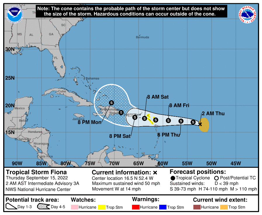
kevin wrote:Owasso wrote:SUMMARY OF 200 AM AST...0600 UTC...INFORMATION
----------------------------------------------
LOCATION...16.5N 52.4W
ABOUT 625 MI...1005 KM E OF THE LEEWARD ISLANDS
MAXIMUM SUSTAINED WINDS...50 MPH...85 KM/H
PRESENT MOVEMENT...W OR 270 DEGREES AT 14 MPH...23 KM/H
MINIMUM CENTRAL PRESSURE...1002 MB...29.59 INCHES
https://i.postimg.cc/NM7kx96z/D6-AA0097-AA30-46-C9-A70-F-2-E74-AF42-C203.png
Shifted to the south slightly.
Based on the cone it does not seem out of the question that Fiona could pass in between Puerto Rico and DR. In that case the islands could still get a lot of rain/wind, but Fiona's core might remain undisturbed and could thus intensify more than most models show right now.
Never use the 5-yr error cone for any impact predictions. It's meaningless for any storm. The cone represents only typical error over the past 5 seasons. It does not indicate any level of forecast certainty or uncertainty regarding the current storm, nor does it imply any impact region. Fiona will likely remain sheared as it passes through the NE Caribbean this weekend. As such, most, if not all, significant squalls and wind will be located northeast through southeast of the center. Don't expect too much near the center. This means the worst weather will occur after the center passes.
12 likes
-
skyline385

- Category 5
- Posts: 2728
- Age: 35
- Joined: Wed Aug 26, 2020 11:15 pm
- Location: Houston TX

-
Blown Away

- S2K Supporter

- Posts: 10253
- Joined: Wed May 26, 2004 6:17 am
Re: ATL: FIONA - Tropical Storm - Discussion

Fiona's LLC getting a bit more exposed IMO and maybe a just S of West movement now?
2 likes
Hurricane Eye Experience: David 79, Irene 99, Frances 04, Jeanne 04, Wilma 05… Hurricane Brush Experience: Andrew 92, Erin 95, Floyd 99, Matthew 16, Irma 17, Ian 22, Nicole 22…
-
BensonTCwatcher

- Category 5
- Posts: 1050
- Joined: Sat Aug 28, 2004 10:11 pm
- Location: Southport NC
Re: ATL: FIONA - Tropical Storm - Discussion
Definitely tilted, maybe on trying to de-couple the MLC if this keeps up . There is also still some mid level dry air upstream and another larger bit to the SW upstream that will certainly keep lid on things.
0 likes
-
PTrackerLA

- Category 5
- Posts: 5281
- Age: 42
- Joined: Thu Oct 10, 2002 8:40 pm
- Location: Lafayette, LA
Re: ATL: FIONA - Tropical Storm - Discussion
Can really see the decoupling occurring in a wider visible loop. IMO we will continue to see the ensemble envelopes shift west today.

2 likes
Re: ATL: FIONA - Tropical Storm - Discussion
Blown Away wrote:https://i.imgur.com/sUMytX8.gif
Fiona's LLC getting a bit more exposed IMO and maybe a just S of West movement now?
Per satellite loops, it at least appears to be moving ever so slightly south of due west vs the 5AM NHC's ever so slight north of due west. It may very well be as far south as 16.5 or possibly even 16.4 N now though sometimes the satellite suggested location doesn't match the actual. If it is at 16.4-5 N, that would be slightly south (by ~15 miles) of the 5 AM implied 16.6-7 N now. If that's true (although 15 miles may not seem like much), that would imply a slight southward track adjustment at 11AM.
Other opinions on a likely 11 AM track adjustment?
2 likes
Personal Forecast Disclaimer:
The posts in this forum are NOT official forecasts and should not be used as such. They are just the opinion of the poster and may or may not be backed by sound meteorological data. They are NOT endorsed by any professional institution or storm2k.org. For official information, please refer to the NHC and NWS products.
The posts in this forum are NOT official forecasts and should not be used as such. They are just the opinion of the poster and may or may not be backed by sound meteorological data. They are NOT endorsed by any professional institution or storm2k.org. For official information, please refer to the NHC and NWS products.
-
SFLcane

- S2K Supporter
- Posts: 10281
- Age: 48
- Joined: Sat Jun 05, 2010 1:44 pm
- Location: Lake Worth Florida
Re: ATL: FIONA - Tropical Storm - Discussion
LarryWx wrote:Blown Away wrote:https://i.imgur.com/sUMytX8.gif
Fiona's LLC getting a bit more exposed IMO and maybe a just S of West movement now?
Per satellite loops, it at least appears to be moving ever so slightly south of due west vs the 5AM NHC's ever so slight north of due west. It may very well be as far south as 16.5 or possibly even 16.4 N now though sometimes the satellite suggested location doesn't match the actual. If it is at 16.4-5 N, that would be slightly south (by ~15 miles) of the 5 AM implied 16.6-7 N now. If that's true (although 15 miles may not seem like much), that would imply a slight southward track adjustment at 11AM.
Other opinions on a likely 11 AM track adjustment?
Don't see any adjustments at 11am but as the post above mentioned i also think we will see the models gradually trend west given the exposed llc.
1 likes
-
Iceresistance

- Category 5
- Posts: 9592
- Age: 22
- Joined: Sat Oct 10, 2020 9:45 am
- Location: Tecumseh, OK/Norman, OK
Re: ATL: FIONA - Tropical Storm - Discussion

4 likes
Bill 2015 & Beta 2020
Winter 2020-2021
All observations are in Tecumseh, OK unless otherwise noted.
Winter posts are focused mainly for Oklahoma & Texas.
Take any of my forecasts with a grain of salt, refer to the NWS, SPC, and NHC for official information
Never say Never with weather! Because ANYTHING is possible!
Winter 2020-2021
All observations are in Tecumseh, OK unless otherwise noted.
Winter posts are focused mainly for Oklahoma & Texas.
Take any of my forecasts with a grain of salt, refer to the NWS, SPC, and NHC for official information
Never say Never with weather! Because ANYTHING is possible!
-
Blown Away
- S2K Supporter
- Posts: 10253
- Joined: Wed May 26, 2004 6:17 am
Re: ATL: FIONA - Tropical Storm - Discussion
SFLcane wrote:LarryWx wrote:Blown Away wrote:https://i.imgur.com/sUMytX8.gif
Fiona's LLC getting a bit more exposed IMO and maybe a just S of West movement now?
Per satellite loops, it at least appears to be moving ever so slightly south of due west vs the 5AM NHC's ever so slight north of due west. It may very well be as far south as 16.5 or possibly even 16.4 N now though sometimes the satellite suggested location doesn't match the actual. If it is at 16.4-5 N, that would be slightly south (by ~15 miles) of the 5 AM implied 16.6-7 N now. If that's true (although 15 miles may not seem like much), that would imply a slight southward track adjustment at 11AM.
Other opinions on a likely 11 AM track adjustment?
Don't see any adjustments at 11am but as the post above mentioned i also think we will see the models gradually trend west given the exposed llc.
NHC Forecasts:
8am - 16.6N - Moving 270
5am - 16.6N - Moving 270
11pm - 16.7N - Moving 280
5pm - 16.8N - Moving 280
11am - 16.6N - Moving 280
Fiona has not gained latitude since the first advisory yesterday and has moved due W (270) since. ECENS trending way W, a track adjustment likely at 11am with full impact into Hispaniola and out into SE Bahamas as maybe a TD moving NW at day 5. My amateur guess.
4 likes
Hurricane Eye Experience: David 79, Irene 99, Frances 04, Jeanne 04, Wilma 05… Hurricane Brush Experience: Andrew 92, Erin 95, Floyd 99, Matthew 16, Irma 17, Ian 22, Nicole 22…
-
AutoPenalti
- Category 5
- Posts: 4091
- Age: 29
- Joined: Mon Aug 17, 2015 4:16 pm
- Location: Ft. Lauderdale, Florida
Re: ATL: FIONA - Tropical Storm - Discussion
Iceresistance wrote:The outflow is almost perfect!
https://s4.gifyu.com/images/tccapture.gif
https://s4.gifyu.com/images/tccapture.gif
Yeah but it goes to show that shear is at the lower levels. So either the convection will start to chase the LLC or a new LLC will develop underneath it.
0 likes
The posts in this forum are NOT official forecasts and should not be used as such. They are just the opinion of the poster and may or may not be backed by sound meteorological data. They are NOT endorsed by any professional institution or STORM2K. For official information, please refer to products from the NHC and NWS.
Model Runs Cheat Sheet:
GFS (5:30 AM/PM, 11:30 AM/PM)
HWRF, GFDL, UKMET, NAVGEM (6:30-8:00 AM/PM, 12:30-2:00 AM/PM)
ECMWF (1:45 AM/PM)
TCVN is a weighted averaged

Re: ATL: FIONA - Tropical Storm - Discussion
I have no doubt Fiona will tighten up and become more vertically stacked as it slows down some when it gets to the Lesser Antilles.
Earl started intensifying as well under 25 knots of shear.
Earl started intensifying as well under 25 knots of shear.
1 likes
-
Iceresistance
- Category 5
- Posts: 9592
- Age: 22
- Joined: Sat Oct 10, 2020 9:45 am
- Location: Tecumseh, OK/Norman, OK
Re: ATL: FIONA - Tropical Storm - Discussion

9 likes
Bill 2015 & Beta 2020
Winter 2020-2021
All observations are in Tecumseh, OK unless otherwise noted.
Winter posts are focused mainly for Oklahoma & Texas.
Take any of my forecasts with a grain of salt, refer to the NWS, SPC, and NHC for official information
Never say Never with weather! Because ANYTHING is possible!
Winter 2020-2021
All observations are in Tecumseh, OK unless otherwise noted.
Winter posts are focused mainly for Oklahoma & Texas.
Take any of my forecasts with a grain of salt, refer to the NWS, SPC, and NHC for official information
Never say Never with weather! Because ANYTHING is possible!
Re: ATL: FIONA - Tropical Storm - Discussion
11 AM NHC kept it at 16.6N (straight west since last advisory).
0 likes
Personal Forecast Disclaimer:
The posts in this forum are NOT official forecasts and should not be used as such. They are just the opinion of the poster and may or may not be backed by sound meteorological data. They are NOT endorsed by any professional institution or storm2k.org. For official information, please refer to the NHC and NWS products.
The posts in this forum are NOT official forecasts and should not be used as such. They are just the opinion of the poster and may or may not be backed by sound meteorological data. They are NOT endorsed by any professional institution or storm2k.org. For official information, please refer to the NHC and NWS products.
-
wxman57
- Moderator-Pro Met
- Posts: 23175
- Age: 68
- Joined: Sat Jun 21, 2003 8:06 pm
- Location: Houston, TX (southwest)
Re: ATL: FIONA - Tropical Storm - Discussion
Here's a plot of the latest NHC track (red) vs. consensus (TVCN) in blue. Looks like NHC may have one point a little too far south as it passes PR. Just a 0.1 deg north adjustment there would smooth out their track. Numbers are date/time (in CDT). They're staying right with consensus until it passes PR, then east of consensus. Their track is right on top of mine (which I didn't plot).

3 likes
-
Sciencerocks
- Category 5
- Posts: 10186
- Age: 40
- Joined: Thu Jul 06, 2017 1:51 am


Re: ATL: FIONA - Tropical Storm - Discussion
AF303 is about to take off for Fiona.
0 likes
Irene '11 Sandy '12 Hermine '16 5/15/2018 Derecho Fay '20 Isaias '20 Elsa '21 Henri '21 Ida '21
I am only a meteorology enthusiast who knows a decent amount about tropical cyclones. Look to the professional mets, the NHC, or your local weather office for the best information.
I am only a meteorology enthusiast who knows a decent amount about tropical cyclones. Look to the professional mets, the NHC, or your local weather office for the best information.
Who is online
Users browsing this forum: No registered users and 29 guests