ATL: FIONA - Post-Tropical - Discussion

Moderator: S2k Moderators

Message
Author
hipshot
Category 2
Category 2
Posts: 591
Joined: Tue Jul 06, 2010 9:18 pm
Location: Dallas, Texas

Re: ATL: FIONA - Hurricane - Discussion

#981 Postby hipshot » Sun Sep 18, 2022 9:45 pm

tolakram wrote:Josh Morgerman (iCyclone) is in Boca de Yuma, tip of cyan arrow.

https://i.imgur.com/nCPeUSN.png

Sure hope Josh is in a good save spot because he may get the eye!! :(
0 likes   

tolakram
Admin
Admin
Posts: 20009
Age: 62
Joined: Sun Aug 27, 2006 8:23 pm
Location: Florence, KY (name is Mark)

Re: ATL: FIONA - Hurricane - Discussion

#982 Postby tolakram » Sun Sep 18, 2022 9:48 pm

hipshot wrote:
tolakram wrote:Josh Morgerman (iCyclone) is in Boca de Yuma, tip of cyan arrow.

https://i.imgur.com/nCPeUSN.png

Sure hope Josh is in a good save spot because he may get the eye!! :(


I don't think so, my bet is Fiona takes a sharp north turn and starts stair stepping up as the ridge north of it starts to weaken. It has stopped almost all westward progression now that a few more frames of the radar have come in. The wobble watch continues.
4 likes   
M a r k
- - - - -
Join us in chat: Storm2K Chatroom Invite. Android and IOS apps also available.

The posts in this forum are NOT official forecasts and should not be used as such. Posts are NOT endorsed by any professional institution or STORM2K.org. For official information and forecasts, please refer to NHC and NWS products.

User avatar
Hammy
Category 5
Category 5
Posts: 5849
Age: 41
Joined: Fri May 25, 2012 5:25 pm
Contact:

Re: ATL: FIONA - Hurricane - Discussion

#983 Postby Hammy » Sun Sep 18, 2022 9:50 pm

No detectable forward motion on radar over the last hour now
0 likes   
The above post is not official and should not be used as such. It is the opinion of the poster and may or may not be backed by sound meteorological data. It is not endorsed by any professional institution or storm2k.org. For official information, please refer to the NHC and NWS products.

User avatar
skyline385
Category 5
Category 5
Posts: 2728
Age: 35
Joined: Wed Aug 26, 2020 11:15 pm
Location: Houston TX

Re: ATL: FIONA - Hurricane - Discussion

#984 Postby skyline385 » Sun Sep 18, 2022 9:50 pm

hipshot wrote:
tolakram wrote:Josh Morgerman (iCyclone) is in Boca de Yuma, tip of cyan arrow.

https://i.imgur.com/nCPeUSN.png

Sure hope Josh is in a good save spot because he may get the eye!! :(


He is actively hoping he gets the eye seeing twitter activity, and yes he did find lodging to ride the storm out.

 https://twitter.com/iCyclone/status/1571672534289973248


4 likes   

User avatar
skyline385
Category 5
Category 5
Posts: 2728
Age: 35
Joined: Wed Aug 26, 2020 11:15 pm
Location: Houston TX

Re: ATL: FIONA - Hurricane - Discussion

#985 Postby skyline385 » Sun Sep 18, 2022 9:56 pm

Still around 18 hours of rain to go, Fiona is going to break rainfall records for PR at this rate

Image


Sent from my iPhone using Tapatalk
0 likes   

User avatar
blp
Category 5
Category 5
Posts: 2840
Age: 46
Joined: Thu Sep 09, 2004 7:51 pm
Location: Miami, FL
Contact:

Re: ATL: FIONA - Hurricane - Discussion

#986 Postby blp » Sun Sep 18, 2022 9:57 pm

It's making the turn..

11:00 PM AST Sun Sep 18

Location: 18.0°N 68.1°W

Moving: WNW at 10 mph

Min pressure: 982 mb

WNW now

EDIT: maybe NOT looks like they are averaging it out. Still moving WEST.

As mentioned above, Fiona has been moving more westward this
evening, but the longer-term motion estimate is 300/9 kt. With this
westward jog, the center is likely to make landfall in the eastern
portion of the Dominican Republic overnight, and the early portion
of the track forecast has been adjusted accordingly. The dynamical
model guidance insists that a northwestward motion should begin
soon, and the models are in good agreement that Fiona will move
around the western periphery of a subtropical ridge over the next
several days.
Last edited by blp on Sun Sep 18, 2022 10:01 pm, edited 1 time in total.
0 likes   
The following post is NOT an official forecast and should not be used as such. It is just the opinion of the poster and may or may not be backed by sound meteorological data. It is NOT endorsed by any professional institution including storm2k.org For Official Information please refer to the NHC and NWS products.

User avatar
skyline385
Category 5
Category 5
Posts: 2728
Age: 35
Joined: Wed Aug 26, 2020 11:15 pm
Location: Houston TX

Re: ATL: FIONA - Hurricane - Discussion

#987 Postby skyline385 » Sun Sep 18, 2022 10:00 pm

blp wrote:It's making the turn..

11:00 PM AST Sun Sep 18

Location: 18.0°N 68.1°W

Moving: WNW at 10 mph

Min pressure: 982 mb

WNW now


Nah, they are assuming it will make the turn soon. Its in the discussion

As mentioned above, Fiona has been moving more westward this evening, but the longer-term motion estimate is 300/9 kt. With this westward jog, the center is likely to make landfall in the eastern portion of the Dominican Republic overnight, and the early portion of the track forecast has been adjusted accordingly. The dynamical model guidance insists that a northwestward motion should begin soon, and the models are in good agreement that Fiona will move around the western periphery of a subtropical ridge over the next several days.
0 likes   

BobHarlem
Category 5
Category 5
Posts: 2108
Joined: Thu Oct 20, 2005 6:11 pm

Re: ATL: FIONA - Hurricane - Discussion

#988 Postby BobHarlem » Sun Sep 18, 2022 10:01 pm

Recon showing center fixes still a bit sw, slowing down though perhaps.

Image
1 likes   

User avatar
blp
Category 5
Category 5
Posts: 2840
Age: 46
Joined: Thu Sep 09, 2004 7:51 pm
Location: Miami, FL
Contact:

Re: ATL: FIONA - Hurricane - Discussion

#989 Postby blp » Sun Sep 18, 2022 10:02 pm

skyline385 wrote:
blp wrote:It's making the turn..

11:00 PM AST Sun Sep 18

Location: 18.0°N 68.1°W

Moving: WNW at 10 mph

Min pressure: 982 mb

WNW now


Nah, they are assuming it will make the turn soon. Its in the discussion

As mentioned above, Fiona has been moving more westward this evening, but the longer-term motion estimate is 300/9 kt. With this westward jog, the center is likely to make landfall in the eastern portion of the Dominican Republic overnight, and the early portion of the track forecast has been adjusted accordingly. The dynamical model guidance insists that a northwestward motion should begin soon, and the models are in good agreement that Fiona will move around the western periphery of a subtropical ridge over the next several days.


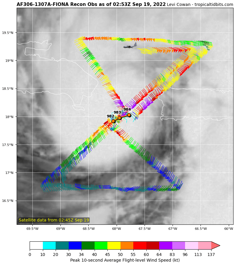
I just saw that. I edited my post. They don't know what it's doing right now..
Last edited by blp on Sun Sep 18, 2022 10:03 pm, edited 2 times in total.
0 likes   
The following post is NOT an official forecast and should not be used as such. It is just the opinion of the poster and may or may not be backed by sound meteorological data. It is NOT endorsed by any professional institution including storm2k.org For Official Information please refer to the NHC and NWS products.

tolakram
Admin
Admin
Posts: 20009
Age: 62
Joined: Sun Aug 27, 2006 8:23 pm
Location: Florence, KY (name is Mark)

Re: ATL: FIONA - Hurricane - Discussion

#990 Postby tolakram » Sun Sep 18, 2022 10:02 pm

Look at the outflow starting to expand on the SW side.

5 likes   
M a r k
- - - - -
Join us in chat: Storm2K Chatroom Invite. Android and IOS apps also available.

The posts in this forum are NOT official forecasts and should not be used as such. Posts are NOT endorsed by any professional institution or STORM2K.org. For official information and forecasts, please refer to NHC and NWS products.

User avatar
Hammy
Category 5
Category 5
Posts: 5849
Age: 41
Joined: Fri May 25, 2012 5:25 pm
Contact:

Re: ATL: FIONA - Hurricane - Discussion

#991 Postby Hammy » Sun Sep 18, 2022 10:03 pm

Image

Forward speed down 50-60% between fixes
1 likes   
The above post is not official and should not be used as such. It is the opinion of the poster and may or may not be backed by sound meteorological data. It is not endorsed by any professional institution or storm2k.org. For official information, please refer to the NHC and NWS products.

User avatar
blp
Category 5
Category 5
Posts: 2840
Age: 46
Joined: Thu Sep 09, 2004 7:51 pm
Location: Miami, FL
Contact:

Re: ATL: FIONA - Hurricane - Discussion

#992 Postby blp » Sun Sep 18, 2022 10:05 pm

Image
0 likes   
The following post is NOT an official forecast and should not be used as such. It is just the opinion of the poster and may or may not be backed by sound meteorological data. It is NOT endorsed by any professional institution including storm2k.org For Official Information please refer to the NHC and NWS products.

User avatar
blp
Category 5
Category 5
Posts: 2840
Age: 46
Joined: Thu Sep 09, 2004 7:51 pm
Location: Miami, FL
Contact:

Re: ATL: FIONA - Hurricane - Discussion

#993 Postby blp » Sun Sep 18, 2022 10:06 pm

Hammy wrote:https://i.imgur.com/NJJ76Xj.png

Forward speed down 50-60% between fixes


It's definitely reaching the periphery. This will turn soon.
1 likes   
The following post is NOT an official forecast and should not be used as such. It is just the opinion of the poster and may or may not be backed by sound meteorological data. It is NOT endorsed by any professional institution including storm2k.org For Official Information please refer to the NHC and NWS products.

tolakram
Admin
Admin
Posts: 20009
Age: 62
Joined: Sun Aug 27, 2006 8:23 pm
Location: Florence, KY (name is Mark)

Re: ATL: FIONA - Hurricane - Discussion

#994 Postby tolakram » Sun Sep 18, 2022 10:11 pm

Image

000
WTNT42 KNHC 190255
TCDAT2

Hurricane Fiona Discussion Number 19
NWS National Hurricane Center Miami FL AL072022
1100 PM AST Sun Sep 18 2022

Radar imagery and recent fixes from an Air Force Reserve Hurricane
Hunter aircraft show that Fiona has jogged westward over the Mona
Passage, in between Puerto Rico and the Dominican Republic this
evening. Radar, microwave imagery, and observations from the
aircraft indicate that the eye has become smaller, with the radius
of maximum winds decreasing to 10-15 n mi. There has been some
warming of the clouds tops in the band just outside the CDO, but the
conventional satellite presentation has not changed much since late
this afternoon. The aircraft has measured a peak 700-mb flight-
level wind of 75 kt, and SFMR winds of around 70 kt. A dropwindsonde
in the northwestern eyewall measured a mean wind of 89 kt in the
lowest 150 m of the profile, which supports the 75 kt initial
intensity. The aircraft just reported a minimum pressure of 982 mb
on it latest pass through the center just a short time ago.

As mentioned above, Fiona has been moving more westward this
evening, but the longer-term motion estimate is 300/9 kt. With this
westward jog, the center is likely to make landfall in the eastern
portion of the Dominican Republic overnight, and the early portion
of the track forecast has been adjusted accordingly. The dynamical
model guidance insists that a northwestward motion should begin
soon, and the models are in good agreement that Fiona will move
around the western periphery of a subtropical ridge over the next
several days. Later in the forecast period, Fiona is forecast to
accelerate northeastward, and north-northeastward ahead of a trough
that is expected to move across the northeastern United States by
the end of the week. The official forecast is near the center of
the guidance envelope, but is slightly slower than the previous
forecast at days 4 and 5 to be closer to the latest consensus aids.

Fiona could strengthen slightly within the next few hours before it
reaches the coast of the Dominican Republic overnight. After that
time, some weakening could occur while the center remains near
eastern Hispaniola. Once Fiona moves over the Atlantic waters
north of the Dominican Republic, the hurricane will be over warm
water and in fairly moist environment. Although there is likely to
be some moderate shear over the hurricane, nearly all of the
intensity models suggest the cyclone will strengthen, and the
official forecast again calls for Fiona to become a major hurricane
in a couple of days. The NHC intensity forecast is close to the
IVCN intensity aid, and is similar to the previous wind speed
forecast.

Based on Fiona's latest forecast track, the government of the
Bahamas has issued a Hurricane Warning for the Turks and Caicos
Islands.

Key Messages:

1. Hurricane conditions are expected to begin in portions of the
warning area in the Dominican Republic within the next few hours.
Tropical storm conditions will continue to spread over portions of
the Dominican Republic within the warning area through Monday.

2. Heavy rains from Fiona will continue across Puerto Rico overnight
tonight and spread over the Dominican Republic through Monday.
These rains will continue to produce life-threatening and
catastrophic flash and urban flooding across Puerto Rico and
portions of the eastern Dominican Republic, along with mudslides and
landslides in areas of higher terrain.

3. Fiona is forecast to continue to strengthen after moving away
from Puerto Rico and the Dominican Republic. Hurricane conditions
are expected in portions of the Turks and Caicos Islands on Tuesday,
and tropical storm conditions are expected in the southeastern
Bahamas by late Monday or early Tuesday.


FORECAST POSITIONS AND MAX WINDS

INIT 19/0300Z 18.0N 68.1W 75 KT 85 MPH
12H 19/1200Z 19.0N 69.1W 80 KT 90 MPH
24H 20/0000Z 20.4N 70.0W 90 KT 105 MPH
36H 20/1200Z 21.9N 70.8W 95 KT 110 MPH
48H 21/0000Z 23.3N 71.1W 100 KT 115 MPH
60H 21/1200Z 24.7N 71.1W 105 KT 120 MPH
72H 22/0000Z 26.4N 70.5W 110 KT 125 MPH
96H 23/0000Z 31.2N 67.4W 110 KT 125 MPH
120H 24/0000Z 40.3N 59.8W 95 KT 110 MPH

$$
Forecaster Brown
0 likes   
M a r k
- - - - -
Join us in chat: Storm2K Chatroom Invite. Android and IOS apps also available.

The posts in this forum are NOT official forecasts and should not be used as such. Posts are NOT endorsed by any professional institution or STORM2K.org. For official information and forecasts, please refer to NHC and NWS products.

User avatar
tropicwatch
Category 5
Category 5
Posts: 3385
Age: 61
Joined: Sat Jun 02, 2007 10:01 am
Location: Panama City Florida
Contact:

Re: ATL: FIONA - Hurricane - Discussion

#995 Postby tropicwatch » Sun Sep 18, 2022 10:11 pm

weeniepatrol wrote:https://i.imgur.com/iUpZJa3.gif

outflow

Upper low to the NE is well-positioned for ventilation


Yes and the upper low appears to be moving westward.
0 likes   
Tropicwatch


Agnes 72', Eloise 75, Elena 85', Kate 85', Charley 86', Florence 88', Beryl 94', Dean 95', Erin 95', Opal 95', Earl 98', Georges 98', Ivan 2004', Arlene 2005', Dennis 2005', Ida 2009' Debby 2012' Irma 2017' Michael 2018'

Sciencerocks
Category 5
Category 5
Posts: 9155
Age: 39
Joined: Thu Jul 06, 2017 1:51 am

Re: ATL: FIONA - Hurricane - Discussion

#996 Postby Sciencerocks » Sun Sep 18, 2022 10:17 pm

Image
2 likes   

tolakram
Admin
Admin
Posts: 20009
Age: 62
Joined: Sun Aug 27, 2006 8:23 pm
Location: Florence, KY (name is Mark)

Re: ATL: FIONA - Hurricane - Discussion

#997 Postby tolakram » Sun Sep 18, 2022 10:25 pm

Image
3 likes   
M a r k
- - - - -
Join us in chat: Storm2K Chatroom Invite. Android and IOS apps also available.

The posts in this forum are NOT official forecasts and should not be used as such. Posts are NOT endorsed by any professional institution or STORM2K.org. For official information and forecasts, please refer to NHC and NWS products.

tolakram
Admin
Admin
Posts: 20009
Age: 62
Joined: Sun Aug 27, 2006 8:23 pm
Location: Florence, KY (name is Mark)

Re: ATL: FIONA - Hurricane - Discussion

#998 Postby tolakram » Sun Sep 18, 2022 10:29 pm

Image
2 likes   
M a r k
- - - - -
Join us in chat: Storm2K Chatroom Invite. Android and IOS apps also available.

The posts in this forum are NOT official forecasts and should not be used as such. Posts are NOT endorsed by any professional institution or STORM2K.org. For official information and forecasts, please refer to NHC and NWS products.

tolakram
Admin
Admin
Posts: 20009
Age: 62
Joined: Sun Aug 27, 2006 8:23 pm
Location: Florence, KY (name is Mark)

Re: ATL: FIONA - Hurricane - Discussion

#999 Postby tolakram » Sun Sep 18, 2022 10:31 pm

Recon almost to center, still moving slowly west IMO.

Image
0 likes   
M a r k
- - - - -
Join us in chat: Storm2K Chatroom Invite. Android and IOS apps also available.

The posts in this forum are NOT official forecasts and should not be used as such. Posts are NOT endorsed by any professional institution or STORM2K.org. For official information and forecasts, please refer to NHC and NWS products.

User avatar
aspen
Category 5
Category 5
Posts: 8818
Joined: Sat Oct 12, 2019 7:10 pm
Location: Connecticut, USA

Re: ATL: FIONA - Hurricane - Discussion

#1000 Postby aspen » Sun Sep 18, 2022 10:36 pm

The center has jumped NW this pass, and the extrapolated pressure has fallen to exactly 980mb. Fiona’s turn has begun.
0 likes   
Irene '11 Sandy '12 Hermine '16 5/15/2018 Derecho Fay '20 Isaias '20 Elsa '21 Henri '21 Ida '21

I am only a meteorology enthusiast who knows a decent amount about tropical cyclones. Look to the professional mets, the NHC, or your local weather office for the best information.


Return to “2022”

Who is online

Users browsing this forum: No registered users and 14 guests