
tolakram wrote:Josh Morgerman (iCyclone) is in Boca de Yuma, tip of cyan arrow.
https://i.imgur.com/nCPeUSN.png
Sure hope Josh is in a good save spot because he may get the eye!!
Moderator: S2k Moderators
tolakram wrote:Josh Morgerman (iCyclone) is in Boca de Yuma, tip of cyan arrow.
https://i.imgur.com/nCPeUSN.png

hipshot wrote:tolakram wrote:Josh Morgerman (iCyclone) is in Boca de Yuma, tip of cyan arrow.
https://i.imgur.com/nCPeUSN.png
Sure hope Josh is in a good save spot because he may get the eye!!


hipshot wrote:tolakram wrote:Josh Morgerman (iCyclone) is in Boca de Yuma, tip of cyan arrow.
https://i.imgur.com/nCPeUSN.png
Sure hope Josh is in a good save spot because he may get the eye!!

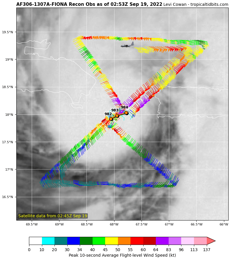
As mentioned above, Fiona has been moving more westward this
evening, but the longer-term motion estimate is 300/9 kt. With this
westward jog, the center is likely to make landfall in the eastern
portion of the Dominican Republic overnight, and the early portion
of the track forecast has been adjusted accordingly. The dynamical
model guidance insists that a northwestward motion should begin
soon, and the models are in good agreement that Fiona will move
around the western periphery of a subtropical ridge over the next
several days.
blp wrote:It's making the turn..
11:00 PM AST Sun Sep 18
Location: 18.0°N 68.1°W
Moving: WNW at 10 mph
Min pressure: 982 mb
WNW now
As mentioned above, Fiona has been moving more westward this evening, but the longer-term motion estimate is 300/9 kt. With this westward jog, the center is likely to make landfall in the eastern portion of the Dominican Republic overnight, and the early portion of the track forecast has been adjusted accordingly. The dynamical model guidance insists that a northwestward motion should begin soon, and the models are in good agreement that Fiona will move around the western periphery of a subtropical ridge over the next several days.

skyline385 wrote:blp wrote:It's making the turn..
11:00 PM AST Sun Sep 18
Location: 18.0°N 68.1°W
Moving: WNW at 10 mph
Min pressure: 982 mb
WNW now
Nah, they are assuming it will make the turn soon. Its in the discussionAs mentioned above, Fiona has been moving more westward this evening, but the longer-term motion estimate is 300/9 kt. With this westward jog, the center is likely to make landfall in the eastern portion of the Dominican Republic overnight, and the early portion of the track forecast has been adjusted accordingly. The dynamical model guidance insists that a northwestward motion should begin soon, and the models are in good agreement that Fiona will move around the western periphery of a subtropical ridge over the next several days.


weeniepatrol wrote:https://i.imgur.com/iUpZJa3.gif
outflow
Upper low to the NE is well-positioned for ventilation


Users browsing this forum: No registered users and 33 guests


