ATL: IAN - Models
Moderator: S2k Moderators

Re: ATL: INVEST 98L - Models
Well, I am voting for the EURO simply because it means the trough must be a good one and we'll have fall in Houston finally  very selfish I know. Hopefully wherever it lands folks are prepared and loss of life is minimal.
1 likes

-
gatorcane

- S2K Supporter

- Posts: 23708
- Age: 48
- Joined: Sun Mar 13, 2005 3:54 pm
- Location: Boca Raton, FL
Re: ATL: INVEST 98L - Models
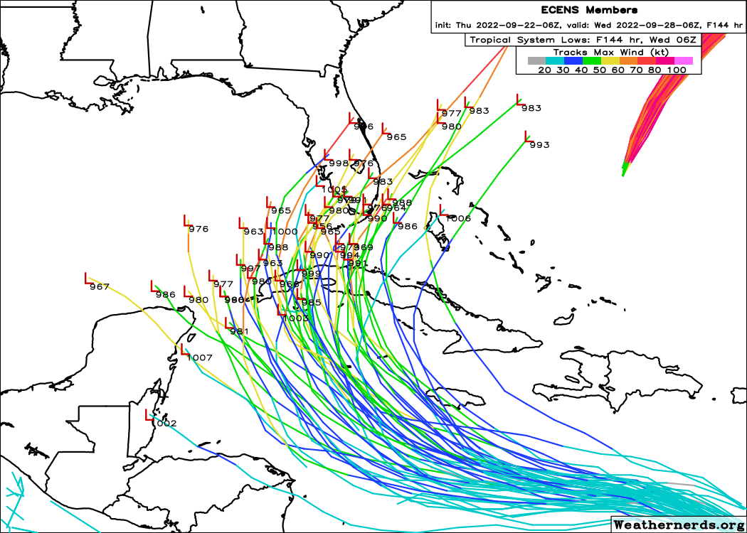
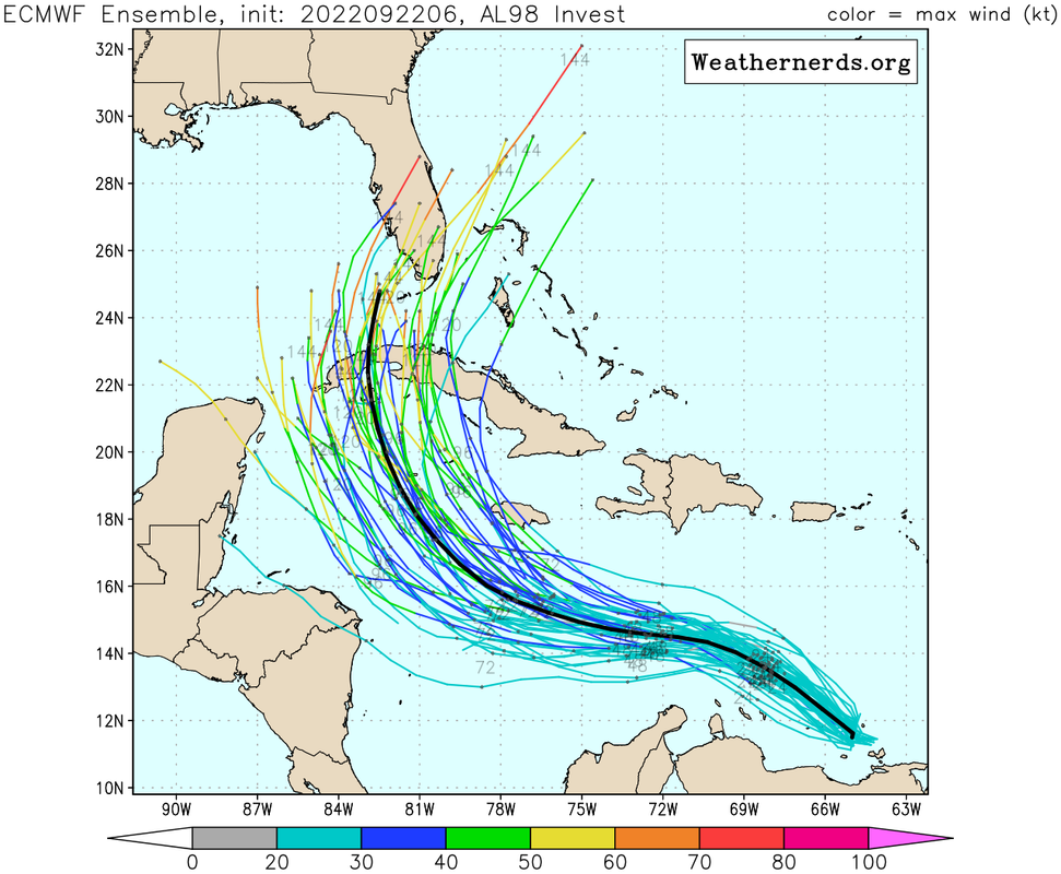
Those Euro ensembles don’t make much sense for September. Looks like more of an October track. My bet is still something like what the TVCN shows, i.e less of a northeast turn and more north across the EGOM or East-Central GOM.
Last edited by gatorcane on Thu Sep 22, 2022 9:39 am, edited 1 time in total.
3 likes
-
cheezyWXguy

- Category 5

- Posts: 6282
- Joined: Mon Feb 13, 2006 12:29 am
- Location: Dallas, TX
Re: ATL: INVEST 98L - Models
p1nheadlarry wrote:Stellar wrote:I think a LOT of people are going to be test-firing their generators over the next few days....here we go....
I should probably invest in one, but thankfully GFS = bad and Euro = good so we're safe here on the northern gulf /s
That’s a bit overly simplified. The gfs is largely on an island by itself (unless you count the Hmon). If you were to weight each model equally and take an average, the tracks taking it that far west hold a fairly small minority of support. I wouldn’t outright discount it though, and from what I can tell, whether it goes east or west comes down to a couple of factors:
- position/amplitude/progression of the trough, as a stronger slower trough is more likely to pick it up
- how the storm develops. In addition to the shear, or possibly as a result of it, the gfs shows competing centers which results in further delay to organization, allowing it to travel further west and feel less influence from the trough. As far as I can tell, it’s the only one to show competing centers to this degree, and already a pretty distinct vorticity center is currently showing up. With this in mind, I tend to favor the eastern consensus at the moment, but we’ll see how it plays out
4 likes

Re: ATL: INVEST 98L - Models
chris_fit wrote:
Just crazy that almost all the EPS are further east (well east) than the OP GFS. Like not even close. Who will win?

Wxman57 has stated he does not think the GFS is realistic. Based on that I will go with the EURO. Unfortunately that puts me in the cross hairs down here in Key West.
I did notice the "Windy" app that a lot of local captains use down here shifted west this morning, taking us out of the "danger zone". I am guessing it uses the GFS. Historically the error is too far west so I really do not like what I am seeing.
I will decide if I want to leave my boat in the water this weekend.
0 likes

Re: ATL: INVEST 98L - Models
Jr0d wrote:chris_fit wrote:
Just crazy that almost all the EPS are further east (well east) than the OP GFS. Like not even close. Who will win?
Wxman57 has stated he does not think the GFS is realistic. Based on that I will go with the EURO. Unfortunately that puts me in the cross hairs down here in Key West.
I did notice the "Windy" app that a lot of local captains use down here shifted west this morning, taking us out of the "danger zone". I am guessing it uses the GFS. Historically the error is too far west so I really do not like what I am seeing.
I will decide if I want to leave my boat in the water this weekend.
I believe both Windy and Windfinder rely on GPS, which would explain why Key West and Big Pine forecasts show 15-20 kt max all week.
0 likes

-
Iceresistance

- Category 5
- Posts: 9592
- Age: 22
- Joined: Sat Oct 10, 2020 9:45 am
- Location: Tecumseh, OK/Norman, OK
Re: ATL: INVEST 98L - Models
ncapps wrote:FWIW, the 12z NAM isn't really developing it at all.
That's weird, because normally the NAM is insane with the storm intensity, maybe it wants to have none of it?
0 likes
Bill 2015 & Beta 2020
Winter 2020-2021
All observations are in Tecumseh, OK unless otherwise noted.
Winter posts are focused mainly for Oklahoma & Texas.
Take any of my forecasts with a grain of salt, refer to the NWS, SPC, and NHC for official information
Never say Never with weather! Because ANYTHING is possible!
Winter 2020-2021
All observations are in Tecumseh, OK unless otherwise noted.
Winter posts are focused mainly for Oklahoma & Texas.
Take any of my forecasts with a grain of salt, refer to the NWS, SPC, and NHC for official information
Never say Never with weather! Because ANYTHING is possible!

Re: ATL: INVEST 98L - Models
ronjon wrote:SFLcane wrote:chris_fit wrote:
Just crazy that almost all the EPS are further east (well east) than the OP GFS. Like not even close. Who will win?
My money is on the ecmwf and its ensembles but we will see.
The European ensembles are definitely trending east with what appears to be a sharper, deeper trough. Also the more northward path thru the Caribbean is playing a role on ensemble mean future track through S Florida. Still a week away so we all know how much can change.
Isn't the Euro known for overdoing troughs though?
2 likes
Personal Forecast Disclaimer:
The posts in this forum are NOT official forecast and should not be used as such. They are just the opinion of the poster and may or may not be backed by sound meteorological data. They are NOT endorsed by any professional institution or storm2k.org. For official information, please refer to the NHC and NWS products.
The posts in this forum are NOT official forecast and should not be used as such. They are just the opinion of the poster and may or may not be backed by sound meteorological data. They are NOT endorsed by any professional institution or storm2k.org. For official information, please refer to the NHC and NWS products.
-
cheezyWXguy
- Category 5
- Posts: 6282
- Joined: Mon Feb 13, 2006 12:29 am
- Location: Dallas, TX
Re: ATL: INVEST 98L - Models
Iceresistance wrote:ncapps wrote:FWIW, the 12z NAM isn't really developing it at all.
That's weird, because normally the NAM is insane with the storm intensity, maybe it wants to have none of it?
I don’t think the nam can’t see that far south, but even if it could, it’s probably the least credible model for TCs out there
0 likes
-
p1nheadlarry

- Category 2

- Posts: 672
- Age: 34
- Joined: Wed Jan 29, 2014 2:42 pm
- Location: SR County FL
Re: ATL: INVEST 98L - Models
cheezyWXguy wrote:p1nheadlarry wrote:Stellar wrote:I think a LOT of people are going to be test-firing their generators over the next few days....here we go....
I should probably invest in one, but thankfully GFS = bad and Euro = good so we're safe here on the northern gulf /s
That’s a bit overly simplified. The gfs is largely on an island by itself (unless you count the Hmon). If you were to weight each model equally and take an average, the tracks taking it that far west hold a fairly small minority of support. I wouldn’t outright discount it though, and from what I can tell, whether it goes east or west comes down to a couple of factors:
- position/amplitude/progression of the trough, as a stronger slower trough is more likely to pick it up
- how the storm develops. In addition to the shear, or possibly as a result of it, the gfs shows competing centers which results in further delay to organization, allowing it to travel further west and feel less influence from the trough. As far as I can tell, it’s the only one to show competing centers to this degree, and already a pretty distinct vorticity center is currently showing up. With this in mind, I tend to favor the eastern consensus at the moment, but we’ll see how it plays out
I wouldn't outright discount the GFS either, but several here have. That's my point hence the [oversimplified] sarcasm. I agree that the short term progression of 98L is important, and probably more so than what the synoptic pattern will look like down the road as I posted before. Euro could have the short term evolution right but overestimate the UL ridge and trough coming down and vice versa for the GFS. People just seem a lot quicker to trash the GFS than they do the Euro in similar situations on this forum as someone who lurks here and mainly posts when a CONUS threat emerges.
3 likes
--;->#GoNoles--;->.
-
SFLcane

- S2K Supporter
- Posts: 10281
- Age: 48
- Joined: Sat Jun 05, 2010 1:44 pm
- Location: Lake Worth Florida
Re: ATL: INVEST 98L - Models
We get it the NAM and the Nogaps are not developing it. 
Come on people... lol
Come on people... lol
1 likes
-
p1nheadlarry
- Category 2
- Posts: 672
- Age: 34
- Joined: Wed Jan 29, 2014 2:42 pm
- Location: SR County FL
Re: ATL: INVEST 98L - Models
cheezyWXguy wrote:Iceresistance wrote:ncapps wrote:FWIW, the 12z NAM isn't really developing it at all.
That's weird, because normally the NAM is insane with the storm intensity, maybe it wants to have none of it?
I don’t think the nam can’t see that far south, but even if it could, it’s probably the least credible model for TCs out there
And if it could, it would blow up the storm right at the boundary of its domain which would likely crash it a la Joaquin (maybe?) in 2015.
0 likes
--;->#GoNoles--;->.
-
toad strangler

- S2K Supporter
- Posts: 4546
- Joined: Sun Jul 28, 2013 3:09 pm
- Location: Earth
- Contact:
Re: ATL: INVEST 98L - Models
p1nheadlarry wrote:cheezyWXguy wrote:p1nheadlarry wrote:
I should probably invest in one, but thankfully GFS = bad and Euro = good so we're safe here on the northern gulf /s
That’s a bit overly simplified. The gfs is largely on an island by itself (unless you count the Hmon). If you were to weight each model equally and take an average, the tracks taking it that far west hold a fairly small minority of support. I wouldn’t outright discount it though, and from what I can tell, whether it goes east or west comes down to a couple of factors:
- position/amplitude/progression of the trough, as a stronger slower trough is more likely to pick it up
- how the storm develops. In addition to the shear, or possibly as a result of it, the gfs shows competing centers which results in further delay to organization, allowing it to travel further west and feel less influence from the trough. As far as I can tell, it’s the only one to show competing centers to this degree, and already a pretty distinct vorticity center is currently showing up. With this in mind, I tend to favor the eastern consensus at the moment, but we’ll see how it plays out
I wouldn't outright discount the GFS either, but several here have. That's my point hence the [oversimplified] sarcasm. I agree that the short term progression of 98L is important, and probably more so than what the synoptic pattern will look like down the road as I posted before. Euro could have the short term evolution right but overestimate the UL ridge and trough coming down and vice versa for the GFS. People just seem a lot quicker to trash the GFS than they do the Euro in similar situations on this forum as someone who lurks here and mainly posts when a CONUS threat emerges.
OR ..... and probably closer to reality, it might have more to do with wxman57's multiple thoughts on the GFS over the past few days.
Last edited by toad strangler on Thu Sep 22, 2022 10:00 am, edited 1 time in total.
2 likes
My Weather Station
https://www.wunderground.com/dashboard/pws/KFLPORTS603
https://www.wunderground.com/dashboard/pws/KFLPORTS603
Re: ATL: INVEST 98L - Models
cheezyWXguy wrote:Iceresistance wrote:ncapps wrote:FWIW, the 12z NAM isn't really developing it at all.
That's weird, because normally the NAM is insane with the storm intensity, maybe it wants to have none of it?
I don’t think the nam can’t see that far south, but even if it could, it’s probably the least credible model for TCs out there
Not sure. That could be case but it does look like it has a TD/TS forming and moving very North towards Jamaica and Cuba where it seems to get shredded.
0 likes
Re: ATL: INVEST 98L - Models
gatorcane wrote:Those Euro ensembles don’t make much sense for September. Looks like more of an October track. My bet is still something like what the TVCN shows, i.e less of a northeast turn and more north across the EGOM or East-Central GOM.
I agree with you about late Sept climo not favoring the NE tracks across the S half of FL. But that's an Octoberlike upper trough coming into the E US days 4-6 before lifting out. Notice that the faster members are mainly the ones that turn NE across S FL. So, it appears that a big key will be speed of 98L. If it goes faster, it will have a better chance to get caught by the upper trough and move NE over the S half of FL. But, if not fast enough, it very likely won't and would instead likely hit the N Gulf coast anywhere from the FL Big Bend westward to LA.
1 likes
Personal Forecast Disclaimer:
The posts in this forum are NOT official forecasts and should not be used as such. They are just the opinion of the poster and may or may not be backed by sound meteorological data. They are NOT endorsed by any professional institution or storm2k.org. For official information, please refer to the NHC and NWS products.
The posts in this forum are NOT official forecasts and should not be used as such. They are just the opinion of the poster and may or may not be backed by sound meteorological data. They are NOT endorsed by any professional institution or storm2k.org. For official information, please refer to the NHC and NWS products.
-
FLpanhandle91

- Category 5
- Posts: 1039
- Age: 34
- Joined: Mon Sep 13, 2010 3:50 pm
- Location: Fort Walton Beach, FL
Re: ATL: INVEST 98L - Models
I think one thing to note here is that until the trough can get nailed down, there will continue to be large swings and discrepancies among the models. With such a huge steering component still unresolved, there will be no in between. It either misses the trough and gets stuck under ridging (west solutions) or it gets yanked north/NNE by the stronger trough (east solutions). On top of that, there still isn't a closed low for these models to initiate on.
1 likes
-
toad strangler
- S2K Supporter
- Posts: 4546
- Joined: Sun Jul 28, 2013 3:09 pm
- Location: Earth
- Contact:
Re: ATL: INVEST 98L - Models
LarryWx wrote:gatorcane wrote:Those Euro ensembles don’t make much sense for September. Looks like more of an October track. My bet is still something like what the TVCN shows, i.e less of a northeast turn and more north across the EGOM or East-Central GOM.
I agree with you about late Sept climo not favoring the NE tracks across the S half of FL. But that's an Octoberlike upper trough coming into the E US days 4-6 before lifting out. Notice that the faster members are mainly the ones that turn NE across S FL. So, it appears that a big key will be speed of 98L. If it goes faster, it will have a better chance to get caught by the upper trough and move NE over the S half of FL. But, if not fast enough, it very likely won't and would instead likely hit the N Gulf coast anywhere from the FL Big Bend westward to LA.
Charley happened in the first half of August. gator brought that one up earlier and since its 18 years might have not realized how early in the season that was to have this "October" climo track to it. Point being, TC's don't read climo textbooks before planning their trip
Anomalies happen all the time. hmmm
Last edited by toad strangler on Thu Sep 22, 2022 10:08 am, edited 1 time in total.
5 likes
My Weather Station
https://www.wunderground.com/dashboard/pws/KFLPORTS603
https://www.wunderground.com/dashboard/pws/KFLPORTS603
-
gatorcane
- S2K Supporter
- Posts: 23708
- Age: 48
- Joined: Sun Mar 13, 2005 3:54 pm
- Location: Boca Raton, FL
Re: ATL: INVEST 98L - Models
LarryWx wrote:gatorcane wrote:Those Euro ensembles don’t make much sense for September. Looks like more of an October track. My bet is still something like what the TVCN shows, i.e less of a northeast turn and more north across the EGOM or East-Central GOM.
I agree with you about late Sept climo not favoring the NE tracks across the S half of FL. But that's an Octoberlike upper trough coming into the E US days 4-6 before lifting out. Notice that the faster members are mainly the ones that turn NE across S FL. So, it appears that a big key will be speed of 98L. If it goes faster, it will have a better chance to get caught by the upper trough and move NE over the S half of FL. But, if not fast enough, it very likely won't and would instead likely hit the N Gulf coast anywhere from the FL Big Bend westward to LA.
Yes good point, speed is key. How this plays out will be interesting. Of course climo doesn't suggest a NE turn but looking at the latest EPS and Euro OP, it is very much on the table.
2 likes
Who is online
Users browsing this forum: No registered users and 20 guests