ATL: IAN - Models

Moderator: S2k Moderators

Message
Author
sma10
Category 5
Category 5
Posts: 1710
Joined: Tue Aug 02, 2005 1:13 pm

Re: ATL: INVEST 98L - Models

#801 Postby sma10 » Thu Sep 22, 2022 10:47 am

Stormcenter wrote:I know everyone wants to know where 98L
is going (assuming it develops) but to keep
on jumping on every model run and say it’s
going there is ridiculous at this still early stage.


This is true. I didn't mean to suggest SFL will definitely be landfall point - it's too early and only 1 model run. The only takeaway, is that the ICON simply has shifted east
1 likes   

LarryWx
S2K Supporter
S2K Supporter
Posts: 6305
Joined: Sun Sep 07, 2003 2:04 pm
Location: GA

Re: ATL: INVEST 98L - Models

#802 Postby LarryWx » Thu Sep 22, 2022 10:48 am

toad strangler wrote:
LarryWx wrote:
gatorcane wrote:Those Euro ensembles don’t make much sense for September. Looks like more of an October track. My bet is still something like what the TVCN shows, i.e less of a northeast turn and more north across the EGOM or East-Central GOM.


I agree with you about late Sept climo not favoring the NE tracks across the S half of FL. But that's an Octoberlike upper trough coming into the E US days 4-6 before lifting out. Notice that the faster members are mainly the ones that turn NE across S FL. So, it appears that a big key will be speed of 98L. If it goes faster, it will have a better chance to get caught by the upper trough and move NE over the S half of FL. But, if not fast enough, it very likely won't and would instead likely hit the N Gulf coast anywhere from the FL Big Bend westward to LA.


Charley happened in the first half of August. gator brought that one up earlier and since its 18 years might have not realized how early in the season that was to have this "October" climo track to it. Point being, TC's don't read climo textbooks before planning their trip :D
Anomalies happen all the time. hmmm


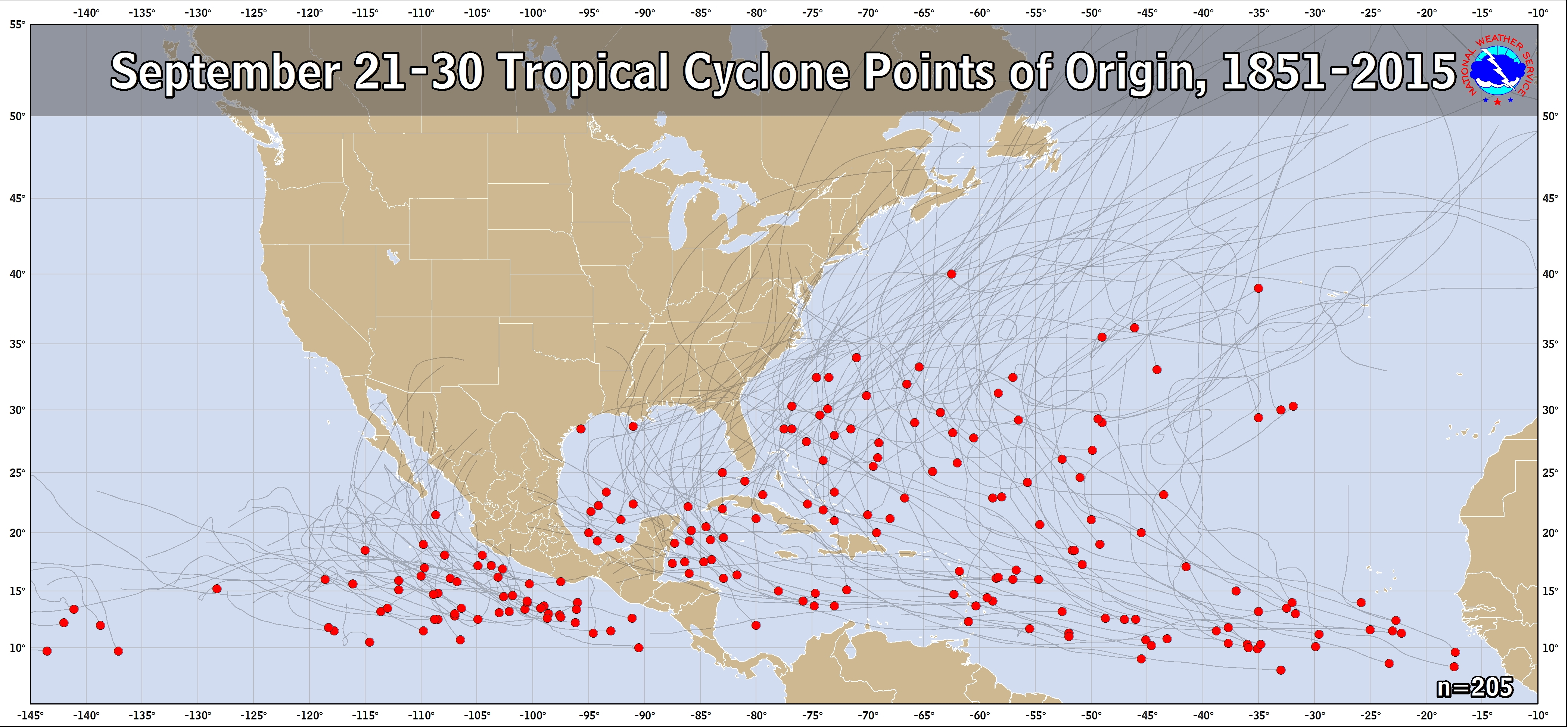
Indeed, mean climo is important to keep in mind but one needs to keep in mind that climo is in reality a mix of many possibilities with tracks on both sides of the mean climo. When folks refer to climo, they're often referring to either the mean or mode track during a period of the calendar. But climo doesn't say that it necessarily has to go near that track to behave per climo. Both the mode and mean for storms with genesis during 9/21-30 (we're looking at progged genesis smack dab in the middle of 9/21-30 making using that period as a good one to use) that later reach the NW Caribbean is clearly not a NE track across the S half of FL. Rather, it is a track toward the FL Panhandle. But if one looks at the history of these tracks, they will see many tracks on both sides of that Panhandle track:

https://www.nhc.noaa.gov/climo/images/sep_21_30.png

On this map one can see that for those that travel over the NW Caribbean that there are many tracks that go anywhere from the E 2/3 of LA all of the way to those that even barely miss S FL to the SE over the NW Bahamas. So, using climo to say that 98L should follow the mean track from the NW Caribbean to the FL Panhandle just because it will have genesis near the middle of 9/21-30 is not using climo the best way imho. Climo says that at or near the FL Panhandle is the highest chance but it doesn't say it is anywhere near the only chance.

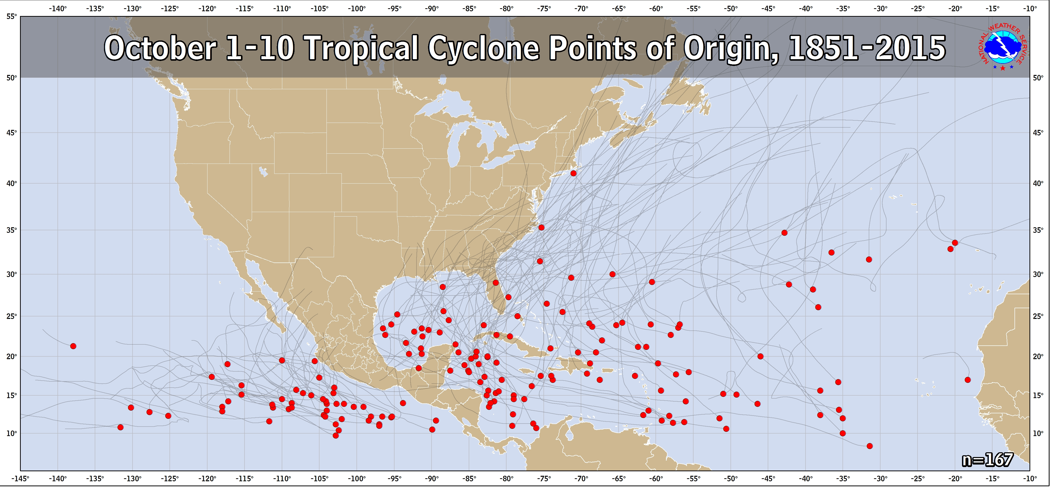
Aside: The map for geneses that occur OCT 1-10 and that are then either already in or later get to the NW Caribbean have a mean track that is further SE than the 9/21-30 geneses tracks with an increased chance for a NE crossing over the S half of FL though even that map has tracks on both sides of that and with the mean near the FL Big Bend:

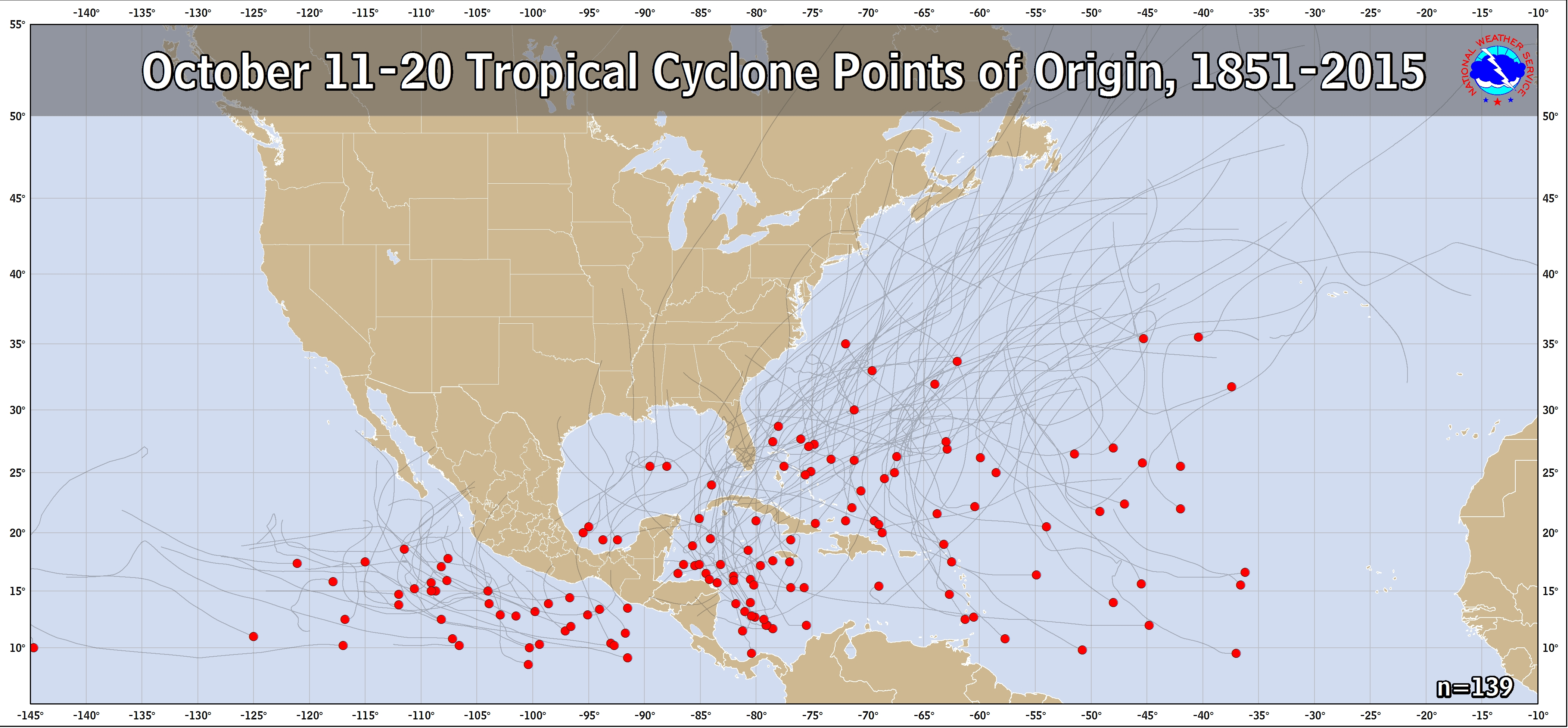
https://www.nhc.noaa.gov/climo/images/oct_1_10.png

If we look at the 10/11-20 map, it has an even further SE mean track near far S FL with many tracks from the NW Caribbean going over the SE third of FL or NW Bahamas:

https://www.nhc.noaa.gov/climo/images/oct_11_20.png
Last edited by LarryWx on Thu Sep 22, 2022 10:49 am, edited 1 time in total.
3 likes   
Personal Forecast Disclaimer:
The posts in this forum are NOT official forecasts and should not be used as such. They are just the opinion of the poster and may or may not be backed by sound meteorological data. They are NOT endorsed by any professional institution or storm2k.org. For official information, please refer to the NHC and NWS products.

tolakram
Admin
Admin
Posts: 20009
Age: 62
Joined: Sun Aug 27, 2006 8:23 pm
Location: Florence, KY (name is Mark)

Re: ATL: INVEST 98L - Models

#803 Postby tolakram » Thu Sep 22, 2022 10:48 am

sma10 wrote:
tolakram wrote:
sma10 wrote:
I've seen it. It goes over Miami


Please source your information.


Well, unfortunately I'm not currently in a position to attach any images. But the run is complete and easily accessible at weather.us


Oh good grief, you mean this run! Should not have doubted you, sorry.

Image
5 likes   
M a r k
- - - - -
Join us in chat: Storm2K Chatroom Invite. Android and IOS apps also available.

The posts in this forum are NOT official forecasts and should not be used as such. Posts are NOT endorsed by any professional institution or STORM2K.org. For official information and forecasts, please refer to NHC and NWS products.

User avatar
SFLcane
S2K Supporter
S2K Supporter
Posts: 10163
Age: 47
Joined: Sat Jun 05, 2010 1:44 pm
Location: Lake Worth Florida

Re: ATL: INVEST 98L - Models

#804 Postby SFLcane » Thu Sep 22, 2022 10:49 am

oooooh!

Image
1 likes   

sma10
Category 5
Category 5
Posts: 1710
Joined: Tue Aug 02, 2005 1:13 pm

Re: ATL: INVEST 98L - Models

#805 Postby sma10 » Thu Sep 22, 2022 10:50 am

tolakram wrote:
sma10 wrote:
tolakram wrote:
Please source your information.


Well, unfortunately I'm not currently in a position to attach any images. But the run is complete and easily accessible at weather.us


Oh good grief, you mean this run!

https://i.imgur.com/80ed7ng.gif


Yes, thank you Mark. Did not mean to cause trouble :D
7 likes   

User avatar
MississippiWx
S2K Supporter
S2K Supporter
Posts: 1699
Joined: Sat Aug 14, 2010 1:44 pm
Location: Hattiesburg, Mississippi

Re: ATL: INVEST 98L - Models

#806 Postby MississippiWx » Thu Sep 22, 2022 10:51 am

GFS has lost a couple of allies in the ICON and CMC in the past few runs. HWRF as well. Still think the GFS is out to lunch. Wild shift to the north and east by the ICON. I guess it goes to show just how sensitive this pattern is to slight changes.
0 likes   
This post is not an official forecast and should not be used as such. It is just the opinion of MississippiWx and may or may not be backed by sound meteorological data. It is not endorsed by any professional institution including storm2k.org. For Official Information please refer to the NHC and NWS products.

User avatar
Kazmit
Category 5
Category 5
Posts: 2124
Age: 22
Joined: Mon Jul 25, 2016 8:49 am
Location: Williamsburg, VA / Bermuda

Re: ATL: INVEST 98L - Models

#807 Postby Kazmit » Thu Sep 22, 2022 10:51 am

12z GFS is already way more north.
0 likes   
Igor 2010, Sandy 2012, Fay 2014, Gonzalo 2014, Joaquin 2015, Nicole 2016, Humberto 2019

I am only a tropical weather enthusiast. My predictions are not official and may or may not be backed by sound meteorological data. For official information, please refer to the NHC and NWS products.

sma10
Category 5
Category 5
Posts: 1710
Joined: Tue Aug 02, 2005 1:13 pm

Re: ATL: INVEST 98L - Models

#808 Postby sma10 » Thu Sep 22, 2022 10:53 am

Kazmit wrote:12z GFS is already way more north.


Yeah GFS at around 60 hours, doing same thing as ICON
0 likes   

tolakram
Admin
Admin
Posts: 20009
Age: 62
Joined: Sun Aug 27, 2006 8:23 pm
Location: Florence, KY (name is Mark)

Re: ATL: INVEST 98L - Models

#809 Postby tolakram » Thu Sep 22, 2022 10:53 am

GFS competing centers

Image
0 likes   
M a r k
- - - - -
Join us in chat: Storm2K Chatroom Invite. Android and IOS apps also available.

The posts in this forum are NOT official forecasts and should not be used as such. Posts are NOT endorsed by any professional institution or STORM2K.org. For official information and forecasts, please refer to NHC and NWS products.

User avatar
MississippiWx
S2K Supporter
S2K Supporter
Posts: 1699
Joined: Sat Aug 14, 2010 1:44 pm
Location: Hattiesburg, Mississippi

Re: ATL: INVEST 98L - Models

#810 Postby MississippiWx » Thu Sep 22, 2022 10:55 am

Yeah, GFS is caving.
1 likes   
This post is not an official forecast and should not be used as such. It is just the opinion of MississippiWx and may or may not be backed by sound meteorological data. It is not endorsed by any professional institution including storm2k.org. For Official Information please refer to the NHC and NWS products.

sma10
Category 5
Category 5
Posts: 1710
Joined: Tue Aug 02, 2005 1:13 pm

Re: ATL: INVEST 98L - Models

#811 Postby sma10 » Thu Sep 22, 2022 10:55 am

tolakram wrote:GFS competing centers

https://i.imgur.com/cABxSN3.png


This may have been the issue all along. GFS prob thought the SW part of the envelope would consolidate. Now the question becomes how far east do the trends go. Could this actually end up doing a Nov-type hard east turn?
0 likes   

tolakram
Admin
Admin
Posts: 20009
Age: 62
Joined: Sun Aug 27, 2006 8:23 pm
Location: Florence, KY (name is Mark)

Re: ATL: INVEST 98L - Models

#812 Postby tolakram » Thu Sep 22, 2022 10:58 am

sma10 wrote:
tolakram wrote:GFS competing centers

https://i.imgur.com/cABxSN3.png


This may have been the issue all along. GFS prob thought the SW part of the envelope would consolidate. Now the question becomes how far east do the trends go. Could this actually end up doing a Nov-type hard east turn?


East of Florida is always on the table, I just don't like to say it until it's clear. This cold front that just came through the midwest is serious. Unfortunately this is also the pattern to give the Florida west coast a solid strike as well.
3 likes   
M a r k
- - - - -
Join us in chat: Storm2K Chatroom Invite. Android and IOS apps also available.

The posts in this forum are NOT official forecasts and should not be used as such. Posts are NOT endorsed by any professional institution or STORM2K.org. For official information and forecasts, please refer to NHC and NWS products.

User avatar
aspen
Category 5
Category 5
Posts: 8818
Joined: Sat Oct 12, 2019 7:10 pm
Location: Connecticut, USA

Re: ATL: INVEST 98L - Models

#813 Postby aspen » Thu Sep 22, 2022 11:00 am

GFS is far weaker than most other models and doesn’t even have a Cat 1 on Monday yet. Heading into the Yucatan again.
0 likes   
Irene '11 Sandy '12 Hermine '16 5/15/2018 Derecho Fay '20 Isaias '20 Elsa '21 Henri '21 Ida '21

I am only a meteorology enthusiast who knows a decent amount about tropical cyclones. Look to the professional mets, the NHC, or your local weather office for the best information.

User avatar
toad strangler
S2K Supporter
S2K Supporter
Posts: 4543
Joined: Sun Jul 28, 2013 3:09 pm
Location: Earth
Contact:

Re: ATL: INVEST 98L - Models

#814 Postby toad strangler » Thu Sep 22, 2022 11:00 am

sma10 wrote:
tolakram wrote:GFS competing centers

https://i.imgur.com/cABxSN3.png


This may have been the issue all along. GFS prob thought the SW part of the envelope would consolidate. Now the question becomes how far east do the trends go. Could this actually end up doing a Nov-type hard east turn?


East of FL is much more likely than LA IMO
2 likes   

User avatar
skyline385
Category 5
Category 5
Posts: 2728
Age: 35
Joined: Wed Aug 26, 2020 11:15 pm
Location: Houston TX

Re: ATL: INVEST 98L - Models

#815 Postby skyline385 » Thu Sep 22, 2022 11:00 am

tolakram wrote:
sma10 wrote:
tolakram wrote:
Please source your information.


Well, unfortunately I'm not currently in a position to attach any images. But the run is complete and easily accessible at weather.us


Oh good grief, you mean this run! Should not have doubted you, sorry.

Image

Guess i get a Cat 2 over me then, although i still think ICON has been overly bullish this season and has been right-biased everytime because of it.


Sent from my iPhone using Tapatalk
0 likes   

sma10
Category 5
Category 5
Posts: 1710
Joined: Tue Aug 02, 2005 1:13 pm

Re: ATL: INVEST 98L - Models

#816 Postby sma10 » Thu Sep 22, 2022 11:00 am

MississippiWx wrote:Yeah, GFS is caving.


It is. But not clear yet if it'll cave as completely as ICON
0 likes   

tolakram
Admin
Admin
Posts: 20009
Age: 62
Joined: Sun Aug 27, 2006 8:23 pm
Location: Florence, KY (name is Mark)

Re: ATL: INVEST 98L - Models

#817 Postby tolakram » Thu Sep 22, 2022 11:01 am

aspen wrote:GFS is far weaker than most other models and doesn’t even have a Cat 1 on Monday yet. Heading into the Yucatan again.


Might want to hang on a few frames.
2 likes   
M a r k
- - - - -
Join us in chat: Storm2K Chatroom Invite. Android and IOS apps also available.

The posts in this forum are NOT official forecasts and should not be used as such. Posts are NOT endorsed by any professional institution or STORM2K.org. For official information and forecasts, please refer to NHC and NWS products.

User avatar
SFLcane
S2K Supporter
S2K Supporter
Posts: 10163
Age: 47
Joined: Sat Jun 05, 2010 1:44 pm
Location: Lake Worth Florida

Re: ATL: INVEST 98L - Models

#818 Postby SFLcane » Thu Sep 22, 2022 11:01 am

0 likes   

tolakram
Admin
Admin
Posts: 20009
Age: 62
Joined: Sun Aug 27, 2006 8:23 pm
Location: Florence, KY (name is Mark)

Re: ATL: INVEST 98L - Models

#819 Postby tolakram » Thu Sep 22, 2022 11:02 am

so far

Image
0 likes   
M a r k
- - - - -
Join us in chat: Storm2K Chatroom Invite. Android and IOS apps also available.

The posts in this forum are NOT official forecasts and should not be used as such. Posts are NOT endorsed by any professional institution or STORM2K.org. For official information and forecasts, please refer to NHC and NWS products.

tolakram
Admin
Admin
Posts: 20009
Age: 62
Joined: Sun Aug 27, 2006 8:23 pm
Location: Florence, KY (name is Mark)

Re: ATL: INVEST 98L - Models

#820 Postby tolakram » Thu Sep 22, 2022 11:03 am

Image
0 likes   
M a r k
- - - - -
Join us in chat: Storm2K Chatroom Invite. Android and IOS apps also available.

The posts in this forum are NOT official forecasts and should not be used as such. Posts are NOT endorsed by any professional institution or STORM2K.org. For official information and forecasts, please refer to NHC and NWS products.


Return to “2022”

Who is online

Users browsing this forum: No registered users and 4 guests