ATL: IAN - Models
Moderator: S2k Moderators
-
gatorcane

- S2K Supporter

- Posts: 23708
- Age: 48
- Joined: Sun Mar 13, 2005 3:54 pm
- Location: Boca Raton, FL
Re: ATL: NINE - Models
Consensus of GFS and Euro is West-Central Florida so Tampa St.Pete Clearwater in the crosshairs at the moment.
Last edited by gatorcane on Fri Sep 23, 2022 1:51 pm, edited 1 time in total.
2 likes

-
skyline385

- Category 5

- Posts: 2728
- Age: 35
- Joined: Wed Aug 26, 2020 11:15 pm
- Location: Houston TX
Re: ATL: NINE - Models
ConvergenceZone wrote:I know that strength is off many times when it comes to models, but what Cat is the EURO now forecasting upon a Florida Landfall? I can never tell by the numbers...
94.2 knots, so high Cat 2 but at those pressures and with a small core could easily be a major. Remember Global models don’t work with small core systems and don’t resolve mesovortices.

Sent from my iPhone using Tapatalk
2 likes
-
tolakram
- Admin

- Posts: 20186
- Age: 62
- Joined: Sun Aug 27, 2006 8:23 pm
- Location: Florence, KY (name is Mark)
Re: ATL: NINE - Models
12Z Euro

1 likes
M a r k
- - - - -
Join us in chat: Storm2K Chatroom Invite. Android and IOS apps also available.
The posts in this forum are NOT official forecasts and should not be used as such. Posts are NOT endorsed by any professional institution or STORM2K.org. For official information and forecasts, please refer to NHC and NWS products.
-
CourierPR

- Category 5
- Posts: 1336
- Age: 72
- Joined: Tue Aug 31, 2004 7:53 pm
- Location: Pompano Beach, Florida
Re: ATL: NINE - Models
gatorcane wrote:Consensus of GFS and Euro is West-Central Florida so Tampa St.Pete Clearwater in the crosshairs at the moment.
I just looked and the Euro is not locked on west-central FL.
0 likes
-
gatorcane
- S2K Supporter
- Posts: 23708
- Age: 48
- Joined: Sun Mar 13, 2005 3:54 pm
- Location: Boca Raton, FL
Re: ATL: NINE - Models
CourierPR wrote:gatorcane wrote:Consensus of GFS and Euro is West-Central Florida so Tampa St.Pete Clearwater in the crosshairs at the moment.
I just looked and the Euro is not locked on west-central FL.
But the consensus of the two models is.
0 likes
-
Hypercane_Kyle

- Category 5
- Posts: 3465
- Joined: Sat Mar 07, 2015 7:58 pm
- Location: Cape Canaveral, FL
Re: ATL: NINE - Models
12z Euro looks similar like the NHC in terms of track & intensity, just a tad further south.
0 likes
My posts are my own personal opinion, defer to the National Hurricane Center (NHC) and other NOAA products for decision making during hurricane season.
-
tolakram
- Admin
- Posts: 20186
- Age: 62
- Joined: Sun Aug 27, 2006 8:23 pm
- Location: Florence, KY (name is Mark)
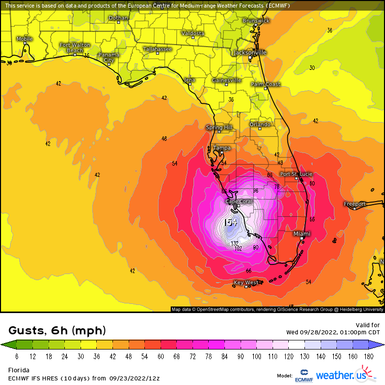
Re: ATL: NINE - Models
Closeup of Euro MSLP and 3H wind gusts. Please keep in mind this is just one model and accuracy of Euro wind gust prediction is unknown.


1 likes
M a r k
- - - - -
Join us in chat: Storm2K Chatroom Invite. Android and IOS apps also available.
The posts in this forum are NOT official forecasts and should not be used as such. Posts are NOT endorsed by any professional institution or STORM2K.org. For official information and forecasts, please refer to NHC and NWS products.
- - - - -
Join us in chat: Storm2K Chatroom Invite. Android and IOS apps also available.
The posts in this forum are NOT official forecasts and should not be used as such. Posts are NOT endorsed by any professional institution or STORM2K.org. For official information and forecasts, please refer to NHC and NWS products.


Re: ATL: NINE - Models
Worth nothing that MLSP usually runs high on the Euro, and most of models other than the HMON and HWRF for that matter. The bigger takeaway is the track and progression, and that if the pressure-conservative euro is showing 949, conditions appear to be ripe for continual intensification.
4 likes
-
tolakram
- Admin
- Posts: 20186
- Age: 62
- Joined: Sun Aug 27, 2006 8:23 pm
- Location: Florence, KY (name is Mark)
Re: ATL: NINE - Models
0 likes
M a r k
- - - - -
Join us in chat: Storm2K Chatroom Invite. Android and IOS apps also available.
The posts in this forum are NOT official forecasts and should not be used as such. Posts are NOT endorsed by any professional institution or STORM2K.org. For official information and forecasts, please refer to NHC and NWS products.
- - - - -
Join us in chat: Storm2K Chatroom Invite. Android and IOS apps also available.
The posts in this forum are NOT official forecasts and should not be used as such. Posts are NOT endorsed by any professional institution or STORM2K.org. For official information and forecasts, please refer to NHC and NWS products.
-
cycloneye

- Admin
- Posts: 149513
- Age: 69
- Joined: Thu Oct 10, 2002 10:54 am
- Location: San Juan, Puerto Rico
Re: ATL: NINE - Models
TVCN goes left.

2 likes
Visit the Caribbean-Central America Weather Thread where you can find at first post web cams,radars
and observations from Caribbean basin members Click Here
and observations from Caribbean basin members Click Here
-
Blown Away

- S2K Supporter
- Posts: 10253
- Joined: Wed May 26, 2004 6:17 am
Re: ATL: NINE - Models
That slight adjustment W going over the skinny/lower part of Cuba helped aide this monster on the other side. JMHO
0 likes
Hurricane Eye Experience: David 79, Irene 99, Frances 04, Jeanne 04, Wilma 05… Hurricane Brush Experience: Andrew 92, Erin 95, Floyd 99, Matthew 16, Irma 17, Ian 22, Nicole 22…
-
tolakram
- Admin
- Posts: 20186
- Age: 62
- Joined: Sun Aug 27, 2006 8:23 pm
- Location: Florence, KY (name is Mark)
Re: ATL: NINE - Models
5 likes
M a r k
- - - - -
Join us in chat: Storm2K Chatroom Invite. Android and IOS apps also available.
The posts in this forum are NOT official forecasts and should not be used as such. Posts are NOT endorsed by any professional institution or STORM2K.org. For official information and forecasts, please refer to NHC and NWS products.
- - - - -
Join us in chat: Storm2K Chatroom Invite. Android and IOS apps also available.
The posts in this forum are NOT official forecasts and should not be used as such. Posts are NOT endorsed by any professional institution or STORM2K.org. For official information and forecasts, please refer to NHC and NWS products.
Re: ATL: NINE - Models
gatorcane wrote:Consensus of GFS and Euro is West-Central Florida so Tampa St.Pete Clearwater in the crosshairs at the moment.
You don't need to be very far west of a northward moving hurricane to escape signifcant impacts. as of now west central florida is on the "good side" of the NHC's track...it is south and east central florida that would get creamed...but of course that can change.
0 likes
Re: ATL: NINE - Models
12Z UKMET 168 is ~100 miles WSW of Tampa heading NNE to NE. Extrapolating this would lean toward it coming ashore a little north of Tampa.
1 likes
Personal Forecast Disclaimer:
The posts in this forum are NOT official forecasts and should not be used as such. They are just the opinion of the poster and may or may not be backed by sound meteorological data. They are NOT endorsed by any professional institution or storm2k.org. For official information, please refer to the NHC and NWS products.
The posts in this forum are NOT official forecasts and should not be used as such. They are just the opinion of the poster and may or may not be backed by sound meteorological data. They are NOT endorsed by any professional institution or storm2k.org. For official information, please refer to the NHC and NWS products.

Re: ATL: NINE - Models
psyclone wrote:gatorcane wrote:Consensus of GFS and Euro is West-Central Florida so Tampa St.Pete Clearwater in the crosshairs at the moment.
You don't need to be very far west of a northward moving hurricane to escape signifcant impacts. as of now west central florida is on the "good side" of the NHC's track...it is south and east central florida that would get creamed...but of course that can change.
Yes but until GFS and HWRF move toward the Euro we still need to be concerned in the Tampa Bay area northward.
1 likes
-
tolakram
- Admin
- Posts: 20186
- Age: 62
- Joined: Sun Aug 27, 2006 8:23 pm
- Location: Florence, KY (name is Mark)
Re: ATL: NINE - Models
A lot slower than previous runs.

1 likes
M a r k
- - - - -
Join us in chat: Storm2K Chatroom Invite. Android and IOS apps also available.
The posts in this forum are NOT official forecasts and should not be used as such. Posts are NOT endorsed by any professional institution or STORM2K.org. For official information and forecasts, please refer to NHC and NWS products.
- - - - -
Join us in chat: Storm2K Chatroom Invite. Android and IOS apps also available.
The posts in this forum are NOT official forecasts and should not be used as such. Posts are NOT endorsed by any professional institution or STORM2K.org. For official information and forecasts, please refer to NHC and NWS products.
Re: ATL: NINE - Models
Hard to tell with that plot, but does it actually stall for a bit over florida on the tvcn there?
0 likes

Re: ATL: NINE - Models
0 likes
TC naming lists: retirements and intensity
Most aggressive Advisory #1's in North Atlantic (cr. kevin for starting the list)
Most aggressive Advisory #1's in North Atlantic (cr. kevin for starting the list)
-
ConvergenceZone
.gif)
- Category 5
- Posts: 5241
- Joined: Fri Jul 29, 2005 1:40 am
- Location: Northern California
Re: ATL: NINE - Models
A bit bummed out that this isn't heading out to sea like I thought the models would move towards today.... Yea I know, I'm guilty of -removed-, but I really thought and was hoping the trend would continue.... Guess it's time to fire up the weather channel the next few days....Not a fan of their regular programing, but they have amazing hurricane coverage.............
3 likes
Who is online
Users browsing this forum: No registered users and 8 guests