ATL: IAN - Models

Moderator: S2k Moderators

Message
Author
User avatar
Nimbus
Category 5
Category 5
Posts: 5302
Joined: Mon Jul 19, 2004 10:54 am

Re: ATL: IAN - Models

#1821 Postby Nimbus » Sat Sep 24, 2022 12:51 pm

aspen wrote:HWRF/HMON both show a peak in the low to mid 930s in the southern Gulf late Tuesday into early Wednesday.


The Euro had a 1022 mb high a little further southwest in yesterdays 12Z run at the start this run the high is initialized over Virginia.
2 likes   

User avatar
gatorcane
S2K Supporter
S2K Supporter
Posts: 23691
Age: 47
Joined: Sun Mar 13, 2005 3:54 pm
Location: Boca Raton, FL

Re: ATL: IAN - Models

#1822 Postby gatorcane » Sat Sep 24, 2022 12:55 pm

Euro 24 hour trend:

Image
Last edited by gatorcane on Sat Sep 24, 2022 12:59 pm, edited 3 times in total.
2 likes   

User avatar
ScottNAtlanta
Category 5
Category 5
Posts: 2367
Joined: Sat May 25, 2013 3:11 pm
Location: Atlanta, GA

Re: ATL: IAN - Models

#1823 Postby ScottNAtlanta » Sat Sep 24, 2022 12:55 pm

ObsessedMiami wrote:Everyone clutching every Magic 8 ball, rabbits foot and Ouija board today for these model runs lol

I prefer burning some white sage, but to each his own :sick:
1 likes   
The posts in this forum are NOT official forecast and should not be used as such. They are just the opinion of the poster and may or may not be backed by sound meteorological data. They are NOT endorsed by any professional institution or storm2k.org. For official information, please refer to the NHC and NWS products.

OuterBanker
S2K Supporter
S2K Supporter
Posts: 1731
Joined: Wed Feb 26, 2003 10:53 am
Location: Nags Head, NC
Contact:

Re: ATL: IAN - Models

#1824 Postby OuterBanker » Sat Sep 24, 2022 12:55 pm

SEASON_CANCELED wrote:
FLWeatherX wrote:
PTrackerLA wrote:I would think the 12z Euro starts to fold to the GFS. 06z ensembles started showing tracks matching GFS so we will see. Something has to give today as this is getting ridiculous.


This is getting ridiculous, but that doesn’t mean the euro has to fold. Euro is better at picking up patterns more than gfs. Gfs has been widely inconsistent, whereas Euro has been consistent on a peninsula hit. Guess we will see


It isnt just GFS. CMC aswell, only outlier seems to be UKMET and whatever EURO does


If the UKMET and Euro agree why would they be the outliers?

If the Euro has been more consistent would not the GFS and CMC be the outliers?
6 likes   

capepoint
Category 1
Category 1
Posts: 415
Joined: Sat Jul 19, 2008 7:13 pm
Location: Beaufort, NC

Re: ATL: IAN - Models

#1825 Postby capepoint » Sat Sep 24, 2022 12:55 pm

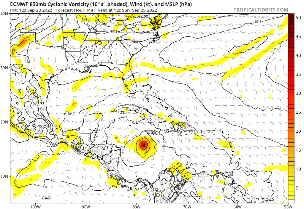
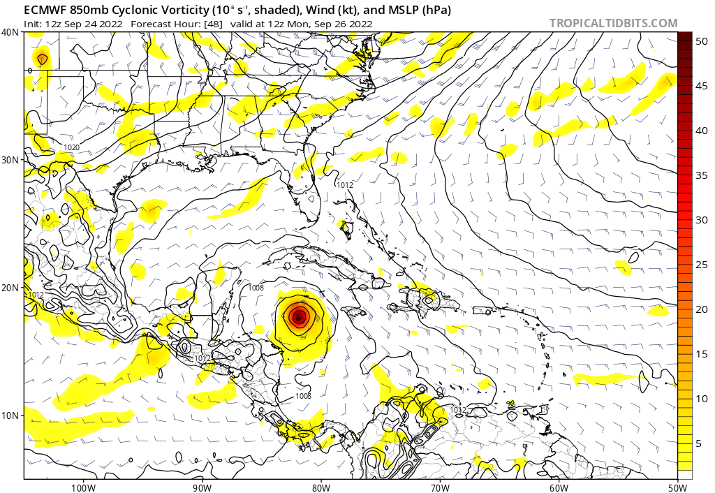
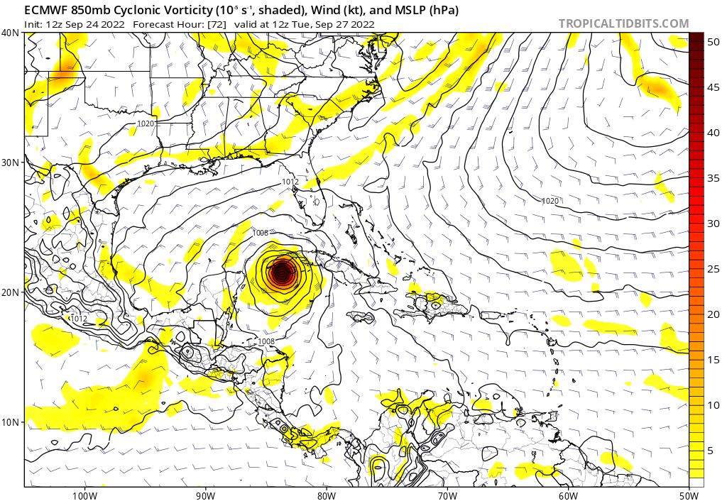
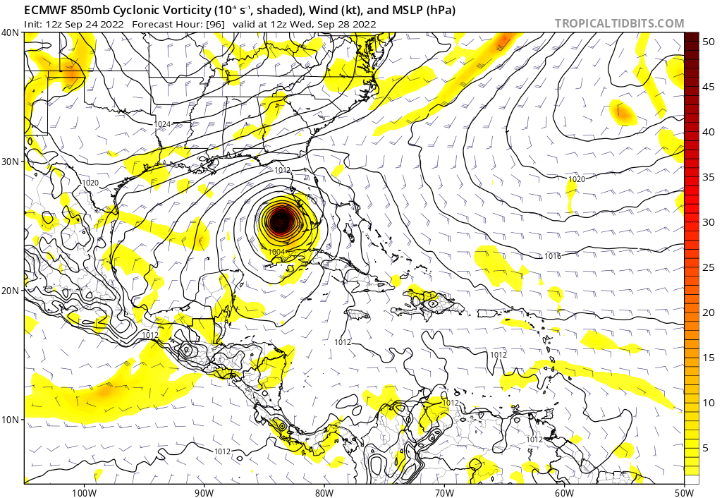
Hypercane_Kyle wrote:The trends on the GFS are interesting, but I'm not sold on it by any means. It's being very inconsistent, shifting as much as 100+ miles west each run. The Euro, thus far, has been very consistent with its solution. If the 12z Euro comes in significantly further north (into the Panhandle), I will be much more inclined to believe the GFS.


And if the European stays with the same general solution as it has been showing for the past 4 days, and it verifies, the GFS will be regulated down to the same reputation level as the Nogaps in Tropical forecasting lol.
1 likes   
Ginger-(eye),Dennis,Diana,Kate,Gloria,Charley-(eye),Allison,Arthur,Bertha,Fran,Josephine,Bonnie,Earl,Dennis-(twice),Floyd, Isabel-(eye),Charley,Ophelia-(eyewall),Ernesto,Barry,Hanna,Irene-(eye),Arthur-(eye), Florence, Dorian, and countless depressions, storms, and nor'easters.

User avatar
eastcoastFL
Category 5
Category 5
Posts: 3901
Age: 43
Joined: Thu Apr 12, 2007 12:29 pm
Location: Palm City, FL

Re: ATL: IAN - Models

#1826 Postby eastcoastFL » Sat Sep 24, 2022 12:56 pm

aspen wrote:HWRF/HMON both show a peak in the low to mid 930s in the southern Gulf late Tuesday into early Wednesday.


Gfs was showing 934mb around the same location before rapidly falling apart on approach
0 likes   
Personal Forecast Disclaimer:
The posts in this forum are NOT official forecast and should not be used as such. They are just the opinion of the poster and may or may not be backed by sound meteorological data. They are NOT endorsed by any professional institution or storm2k.org. For official information, please refer to the NHC and NWS products.

User avatar
SEASON_CANCELED
Category 3
Category 3
Posts: 887
Joined: Mon Jul 06, 2009 5:17 am
Location: 8 Bit Charlie Sheen

Re: ATL: IAN - Models

#1827 Postby SEASON_CANCELED » Sat Sep 24, 2022 12:58 pm

OuterBanker wrote:
SEASON_CANCELED wrote:
FLWeatherX wrote:

This is getting ridiculous, but that doesn’t mean the euro has to fold. Euro is better at picking up patterns more than gfs. Gfs has been widely inconsistent, whereas Euro has been consistent on a peninsula hit. Guess we will see


It isnt just GFS. CMC aswell, only outlier seems to be UKMET and whatever EURO does


If the UKMET and Euro agree why would they be the outliers?

If the Euro has been more consistent would not the GFS and CMC be the outliers?


I am writing under the assumption its gonna jog west. Perhaps you are right
0 likes   
i am a big stupid ugly moron with an ugly face and a big butt and my butt stinks and i like to kiss my own butt

LarryWx
S2K Supporter
S2K Supporter
Posts: 6309
Joined: Sun Sep 07, 2003 2:04 pm
Location: GA

Re: ATL: IAN - Models

#1828 Postby LarryWx » Sat Sep 24, 2022 12:58 pm

12Z Euro 24 slightly SW of 6Z at 30
0 likes   
Personal Forecast Disclaimer:
The posts in this forum are NOT official forecasts and should not be used as such. They are just the opinion of the poster and may or may not be backed by sound meteorological data. They are NOT endorsed by any professional institution or storm2k.org. For official information, please refer to the NHC and NWS products.

User avatar
gatorcane
S2K Supporter
S2K Supporter
Posts: 23691
Age: 47
Joined: Sun Mar 13, 2005 3:54 pm
Location: Boca Raton, FL

Re: ATL: IAN - Models

#1829 Postby gatorcane » Sat Sep 24, 2022 1:01 pm

EURO 48 hours:

Image
0 likes   

User avatar
AJC3
Admin
Admin
Posts: 3999
Age: 61
Joined: Tue Aug 31, 2004 7:04 pm
Location: Ballston Spa, New York
Contact:

Re: ATL: IAN - Models

#1830 Postby AJC3 » Sat Sep 24, 2022 1:02 pm

Quick reminder here as the 12Z ECM comes in...

The mods and admins are watching this thread closely. Back and forth posts that turn into confrontational "team west" vs "team east" subthreads, or declaration of some sort of model being "victorious", especially several days before the event unfolds, will very likely be zapped. As Stacy Stewart once said, model agreement doesn't nescassarily translate into model accuracy.

Yes, we all understand model guidance has improved since 2004, and every synoptic scenario is unique. We get that. Still, this was only about 36 hours from its eventual landfall, so it's good to keep this in the back of your mind before posting.

HURRICANE CHARLEY DISCUSSION NUMBER 12
NWS TPC/NATIONAL HURRICANE CENTER MIAMI FL
5 AM EDT THU AUG 12 2004

THERE HAS BEEN A LEFTWARD SHIFT IN MUCH OF THE TRACK GUIDANCE THIS
MORNING
...WITH THE UKMET AND THE GFDL SHOWING THE GREATEST CHANGE.
DROPSONDE DATA FROM THE G-IV MISSION LAST NIGHT SHOWED A LITTLE
MORE RIDGING OVER WESTERN CUBA AND THIS MAY HAVE BEEN RESPONSIBLE
FOR THE SHIFT. I DO NOT WANT TO MAKE ANY RADICAL CHANGE TO THE
TRACK UNTIL THIS TREND CAN BE CONFIRMED...AND THE OFFICIAL TRACK
HAS BEEN SHIFTED JUST A LITTLE TO THE LEFT FOR THIS ADVISORY. MOST
OF THE GUIDANCE CURRENTLY SHOWS A LANDFALL FROM THE TAMPA AREA
NORTHWARD THROUGH THE BIG BEND AREA. BECAUSE CHARLEY IS EXPECTED TO
APPROACH THE WEST COAST OF FLORIDA COAST AT A SHARPLY OBLIQUE
ANGLE...IT IS UNUSUALLY DIFFICULT TO PINPOINT CHARLEY'S
LANDFALL...AS SMALL ERRORS IN THE TRACK FORECAST WOULD CORRESPOND
TO LARGE ERRORS IN THE LOCATION AND TIMING OF LANDFALL.


RECONNAISSANCE DATA INDICATE THAT CHARLEY STRENGTHENED
OVERNIGHT...WITH PEAK FLIGHT-LEVEL WINDS OF JUST UNDER 100 KT.
BOTH THE SHIPS AND GFDL GUIDANCE INDICATE THAT CHARLEY SHOULD
CONTINUE TO STRENGTHEN. CURRENTLY AN UPPER-LEVEL LOW TO THE WEST
OF THE CYCLONE IS LIMITING OUTFLOW IN THAT QUADRANT...BUT THIS MAY
BECOME LESS OF A FACTOR WHEN CHARLEY ENTERS THE GULF. THE OFFICIAL
FORECAST TAKES CHARLEY TO JUST SHY OF MAJOR HURRICANE STATUS...BUT
IT COULD JUST AS EASILY REACH THAT THRESHOLD PRIOR TO LANDFALL.
SHOULD THIS OCCUR THE POTENTIAL FOR EXTREMELY DANGEROUS STORM SURGE
EXISTS.

FORECASTER FRANKLIN

FORECAST POSITIONS AND MAX WINDS

INITIAL 12/0900Z 18.6N 79.9W 75 KT
12HR VT 12/1800Z 20.3N 81.3W 85 KT
24HR VT 13/0600Z 23.3N 82.5W 85 KT
36HR VT 13/1800Z 26.3N 83.0W 95 KT
48HR VT 14/0600Z 30.5N 82.0W 60 KT...INLAND


Image
19 likes   

LarryWx
S2K Supporter
S2K Supporter
Posts: 6309
Joined: Sun Sep 07, 2003 2:04 pm
Location: GA

Re: ATL: IAN - Models

#1831 Postby LarryWx » Sat Sep 24, 2022 1:03 pm


12Z Euro 48 only very slightly SW of 6Z run at 54
0 likes   
Personal Forecast Disclaimer:
The posts in this forum are NOT official forecasts and should not be used as such. They are just the opinion of the poster and may or may not be backed by sound meteorological data. They are NOT endorsed by any professional institution or storm2k.org. For official information, please refer to the NHC and NWS products.

User avatar
Ivanhater
Storm2k Moderator
Storm2k Moderator
Posts: 11161
Age: 38
Joined: Fri Jul 01, 2005 8:25 am
Location: Pensacola

Re: ATL: IAN - Models

#1832 Postby Ivanhater » Sat Sep 24, 2022 1:05 pm

12Z Hmon and Hwrf joining the Gfs and Cmc camp coming in around Panama city
0 likes   
Michael

User avatar
gatorcane
S2K Supporter
S2K Supporter
Posts: 23691
Age: 47
Joined: Sun Mar 13, 2005 3:54 pm
Location: Boca Raton, FL

Re: ATL: IAN - Models

#1833 Postby gatorcane » Sat Sep 24, 2022 1:07 pm

12Z Euro 72 hours. Looks like it is staying east and not shifting west :eek:

Image
3 likes   

User avatar
chris_fit
Category 5
Category 5
Posts: 3222
Age: 42
Joined: Wed Sep 10, 2003 11:58 pm
Location: Tampa Bay Area, FL

Re: ATL: IAN - Models

#1834 Postby chris_fit » Sat Sep 24, 2022 1:11 pm

gatorcane wrote:12Z Euro 72 hours. Looks like it is staying east and not shifting west :eek:

https://i.postimg.cc/8CJk3nRg/ec-fast-uv850-vort-watl-4.png


Slighhhtly W of the 00Z run - but stronger
1 likes   

LarryWx
S2K Supporter
S2K Supporter
Posts: 6309
Joined: Sun Sep 07, 2003 2:04 pm
Location: GA

Re: ATL: IAN - Models

#1835 Postby LarryWx » Sat Sep 24, 2022 1:14 pm

gatorcane wrote:12Z Euro 72 hours. Looks like it is staying east and not shifting west :eek:

https://i.postimg.cc/8CJk3nRg/ec-fast-uv850-vort-watl-4.png


This 12 Euro 72 is barely NW of 6Z at 78. Essentially the same location.
1 likes   
Personal Forecast Disclaimer:
The posts in this forum are NOT official forecasts and should not be used as such. They are just the opinion of the poster and may or may not be backed by sound meteorological data. They are NOT endorsed by any professional institution or storm2k.org. For official information, please refer to the NHC and NWS products.

User avatar
gatorcane
S2K Supporter
S2K Supporter
Posts: 23691
Age: 47
Joined: Sun Mar 13, 2005 3:54 pm
Location: Boca Raton, FL

Re: ATL: IAN - Models

#1836 Postby gatorcane » Sat Sep 24, 2022 1:15 pm

ECMWF Ut oh west coast of Florida :eek:

Image
Last edited by gatorcane on Sat Sep 24, 2022 1:16 pm, edited 2 times in total.
3 likes   

User avatar
chris_fit
Category 5
Category 5
Posts: 3222
Age: 42
Joined: Wed Sep 10, 2003 11:58 pm
Location: Tampa Bay Area, FL

Re: ATL: IAN - Models

#1837 Postby chris_fit » Sat Sep 24, 2022 1:16 pm

Where to now? What are your guesses? I'm thinking Just N of Tampa Bay

Image
Last edited by chris_fit on Sat Sep 24, 2022 1:17 pm, edited 2 times in total.
5 likes   

User avatar
toad strangler
S2K Supporter
S2K Supporter
Posts: 4543
Joined: Sun Jul 28, 2013 3:09 pm
Location: Earth
Contact:

Re: ATL: IAN - Models

#1838 Postby toad strangler » Sat Sep 24, 2022 1:17 pm

Someone please post 12z Euro 500mb
1 likes   

User avatar
chris_fit
Category 5
Category 5
Posts: 3222
Age: 42
Joined: Wed Sep 10, 2003 11:58 pm
Location: Tampa Bay Area, FL

Re: ATL: IAN - Models

#1839 Postby chris_fit » Sat Sep 24, 2022 1:18 pm

Image
1 likes   

tolakram
Admin
Admin
Posts: 20010
Age: 62
Joined: Sun Aug 27, 2006 8:23 pm
Location: Florence, KY (name is Mark)

Re: ATL: IAN - Models

#1840 Postby tolakram » Sat Sep 24, 2022 1:19 pm

Best EC-Fast has

Image
3 likes   
M a r k
- - - - -
Join us in chat: Storm2K Chatroom Invite. Android and IOS apps also available.

The posts in this forum are NOT official forecasts and should not be used as such. Posts are NOT endorsed by any professional institution or STORM2K.org. For official information and forecasts, please refer to NHC and NWS products.


Return to “2022”

Who is online

Users browsing this forum: No registered users and 3 guests