
ATL: IAN - Models
Moderator: S2k Moderators
-
tolakram
- Admin

- Posts: 20186
- Age: 62
- Joined: Sun Aug 27, 2006 8:23 pm
- Location: Florence, KY (name is Mark)
Re: ATL: IAN - Models
That is very close to no landfall near Tampa, very very close.
3 likes
M a r k
- - - - -
Join us in chat: Storm2K Chatroom Invite. Android and IOS apps also available.
The posts in this forum are NOT official forecasts and should not be used as such. Posts are NOT endorsed by any professional institution or STORM2K.org. For official information and forecasts, please refer to NHC and NWS products.
-
AJC3

- Admin
- Posts: 4156
- Age: 62
- Joined: Tue Aug 31, 2004 7:04 pm
- Location: Ballston Spa, New York
- Contact:
Re: ATL: IAN - Models
chris_fit wrote:12Z Euro Def trending W after it kisses Tampa though.... I think that's a big change
https://i.imgur.com/LEyWk4d.gif
The post-landfall motion looks Irma-esque.
5 likes
-
SEASON_CANCELED

- Category 3

- Posts: 887
- Joined: Mon Jul 06, 2009 5:17 am
- Location: 8 Bit Charlie Sheen
Re: ATL: IAN - Models
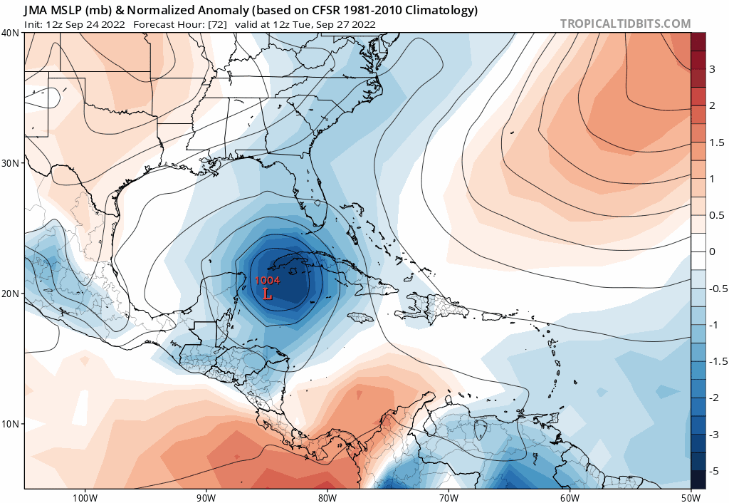
gatorcane wrote:JMA like the Euro also. So it is the Euro/UKMET/JMA vs the GFS/HWRF/CMC:
https://i.postimg.cc/bJ8yJ0DZ/jma-mslpa-Norm-watl-fh72-192.gif
Thats more Bradenton landfall
1 likes
i am a big stupid ugly moron with an ugly face and a big butt and my butt stinks and i like to kiss my own butt
-
tolakram
- Admin
- Posts: 20186
- Age: 62
- Joined: Sun Aug 27, 2006 8:23 pm
- Location: Florence, KY (name is Mark)
Re: ATL: IAN - Models

source: https://weather.us/model-charts/euro/2022092412/848-w-267-n/sea-level-pressure/20220927-1400z.html
1 likes
M a r k
- - - - -
Join us in chat: Storm2K Chatroom Invite. Android and IOS apps also available.
The posts in this forum are NOT official forecasts and should not be used as such. Posts are NOT endorsed by any professional institution or STORM2K.org. For official information and forecasts, please refer to NHC and NWS products.
- - - - -
Join us in chat: Storm2K Chatroom Invite. Android and IOS apps also available.
The posts in this forum are NOT official forecasts and should not be used as such. Posts are NOT endorsed by any professional institution or STORM2K.org. For official information and forecasts, please refer to NHC and NWS products.

Re: ATL: IAN - Models
It will all come down to how fast and deep the trough digs down to pull Ian north, the difference between the Euro and GFS.

4 likes

Re: ATL: IAN - Models
chris_fit wrote:12Z Euro Def trending W after it kisses Tampa though.... I think that's a big change
Definitely could be the start of a westward trend. Ensemble spread for 12z might begin to show it...let's see.
0 likes
-
otowntiger
- Category 5

- Posts: 1932
- Joined: Tue Aug 31, 2004 7:06 pm
Re: ATL: IAN - Models
. You are very likely correct. I also believe that we are still far enough out and there are still enough variables to get worked out and factored in that we could very well see everything shift back east. It’s why we can’t take every shift one way or the other too seriously at this point. But what we are seeing is proof that a wide swath of real estate along the gulf coast that needs to stay very vigilant. That is all of Florida including the Keys, Alabama and Mississippi.Ivanhater wrote:12Z Euro did shift North just north of Tampa.
TVCN will almost certainly shift West again and in turn the NHC track.
New TVCN comes in about 30 min.
0 likes

Re: ATL: IAN - Models
Oh yikes! That takes out Pinellas county and the coastline in Pasco, Hernando and up through Citrus county. I'm 3 miles inland in Pasco.
1 likes
-
AtlanticWind

- S2K Supporter

- Posts: 1898
- Age: 67
- Joined: Sun Aug 08, 2004 9:57 pm
- Location: Plantation,Fla
Re: ATL: IAN - Models
Still would hold off on saying where Ian will come ashore until its center consaldates .
Small differences could change the models considerably I think.
Small differences could change the models considerably I think.
0 likes
-
Blown Away

- S2K Supporter
- Posts: 10253
- Joined: Wed May 26, 2004 6:17 am
Re: ATL: IAN - Models
Euro continues to keep stall in the 6+ day range for days and has not progressed into the close range. 12z GFS generally dropped the stall. If Euro is going to cave W it will likely begin to show it in 00z.
12z Euro shows a very rare major track into just N of Tampa and GFS track into Panhandle much more common.
I wonder if we will see Ian move slower than projected in the near term and result in more progressive movement later?
12z Euro shows a very rare major track into just N of Tampa and GFS track into Panhandle much more common.
I wonder if we will see Ian move slower than projected in the near term and result in more progressive movement later?
1 likes
Hurricane Eye Experience: David 79, Irene 99, Frances 04, Jeanne 04, Wilma 05… Hurricane Brush Experience: Andrew 92, Erin 95, Floyd 99, Matthew 16, Irma 17, Ian 22, Nicole 22…
-
Category5Kaiju

- Category 5
- Posts: 4334
- Joined: Thu Dec 24, 2020 12:45 pm
- Location: Seattle and Phoenix
Re: ATL: IAN - Models
A question I personally have is this: what exactly would the difference in ridging/troughing position and strength have to be for a recurving storm from the WCAR to strike the Panhandle/Mississippi/Alabama region, versus the West Coast of Florida's peninsula?
0 likes
Unless explicitly stated, all info in my posts is based on my own opinions and observations. Tropical storms and hurricanes can be extremely dangerous. Refer to an accredited weather research agency or meteorologist if you need to make serious decisions regarding an approaching storm.
-
cycloneye

- Admin
- Posts: 149508
- Age: 69
- Joined: Thu Oct 10, 2002 10:54 am
- Location: San Juan, Puerto Rico
Re: ATL: IAN - Models
This will be good news for the model huggers as the gulfstream jet gonzo is flying now. The data from it will be incorporated to the models at 00z.
7 likes
Visit the Caribbean-Central America Weather Thread where you can find at first post web cams,radars
and observations from Caribbean basin members Click Here
and observations from Caribbean basin members Click Here
-
Frank P
- S2K Supporter
- Posts: 2779
- Joined: Fri Aug 29, 2003 10:52 am
- Location: Biloxi Beach, Ms
- Contact:
Re: ATL: IAN - Models
That’s a significant shift west by the 12z Euro but most especially after it makes landfall. A slower moving system would allow that shift to occur over the GOM and make the landfall more near the eastern Panhandle. Additionally it spares S FL from the brunt of the system. Quite a change IMO. Foreword motions of the system will play an important part in the ultimate landfall. Faster system more towards the west coast, shower system the Panhandle. Just yesterday it was hitting the up the Atlantic east coast after a FL landfall… that scenario is now gone it appears att
0 likes
-
Emmett_Brown

- Category 5
- Posts: 1433
- Joined: Wed Aug 24, 2005 9:10 pm
- Location: Sarasota FL
Re: ATL: IAN - Models
NDG wrote:It will all come down to how fast and deep the trough digs down to pull Ian north, the difference between the Euro and GFS.
https://i.imgur.com/8d7ASRf.jpg
The trough looks very similar on the Euro and GFS to me. For example, both have the 582 line running through N Carolina by 12Z Wed. The major differences between these 500 mb charts is the location of Ian. So how Ian tracks in the next 72 hours would seem to be very important.
0 likes
-
AJC3
- Admin
- Posts: 4156
- Age: 62
- Joined: Tue Aug 31, 2004 7:04 pm
- Location: Ballston Spa, New York
- Contact:
Re: ATL: IAN - Models
Category5Kaiju wrote:A question I personally have is this: what exactly would the difference in ridging/troughing position and strength have to be for a recurving storm from the WCAR to strike the Panhandle/Mississippi/Alabama region, versus the West Coast of Florida's peninsula?
Once a mid level trough lifts out, the mean layer SW-NE flow steering weakens or collapses. Post-frontal ridging, both surface and aloft, will then build in behind the trough, which is usually accompanied by less favorable environmental conditions (increased upper level shear and a drier/cooler mean air mass). Low level winds shift to N and eventually NE-E (think of fall cold fronts in FL), while winds aloft back to W or NW. If Ian were to miss the trough and move farther N-W, it's much more likely to do so as a much-weakened system.
3 likes
-
SEASON_CANCELED
- Category 3
- Posts: 887
- Joined: Mon Jul 06, 2009 5:17 am
- Location: 8 Bit Charlie Sheen
Re: ATL: IAN - Models
Something is really bothering me about this Run, Primarily that Cuba appears to have no effect on it
Also the angle compared to GFS....GFS shows 100 miles to the west on first frame. These Tracks are entirely dependant on positioning below cuba. We will have to wait and see when that turn happens
Dunno. Watching with anxiety.
Last edited by SEASON_CANCELED on Sat Sep 24, 2022 2:02 pm, edited 1 time in total.
0 likes
i am a big stupid ugly moron with an ugly face and a big butt and my butt stinks and i like to kiss my own butt
-
jlauderdal
- S2K Supporter
- Posts: 7240
- Joined: Wed May 19, 2004 5:46 am
- Location: NE Fort Lauderdale
- Contact:
Re: RE: Re: ATL: IAN - Models
Helpful but until we get a proper center, modeling will be suspect.cycloneye wrote:This will be good news for the model huggers as the gulfstream jet gonzo is flying now. The data from it will be incorporated to the models at 00z.
2 likes
-
jlauderdal
- S2K Supporter
- Posts: 7240
- Joined: Wed May 19, 2004 5:46 am
- Location: NE Fort Lauderdale
- Contact:
Re: RE: Re: ATL: IAN - Models
Western cuba typically has minimal effects on intensity. Plenty of fuel available in that area, relatively flat.SEASON_CANCELED wrote:
Something is really bothering me about this Run, Primarily that Cuba appears to have no effect on it
1 likes
-
AJC3
- Admin
- Posts: 4156
- Age: 62
- Joined: Tue Aug 31, 2004 7:04 pm
- Location: Ballston Spa, New York
- Contact:
Re: ATL: IAN - Models
SEASON_CANCELED wrote:
Something is really bothering me about this Run, Primarily that Cuba appears to have no effect on it
It won't, as was the case with Charley. I've flown over western Cuba at 1000 feet...it's narrow, flat, and consists of farmland which turns into mangroves near the tip.
https://www.weather.gov/media/mlb/resea ... 2_2000.pdf
3 likes
-
cycloneye
- Admin
- Posts: 149508
- Age: 69
- Joined: Thu Oct 10, 2002 10:54 am
- Location: San Juan, Puerto Rico
Re: RE: Re: ATL: IAN - Models
jlauderdal wrote:Helpful but until we get a proper center, modeling will be suspect.cycloneye wrote:This will be good news for the model huggers as the gulfstream jet gonzo is flying now. The data from it will be incorporated to the models at 00z.
That is correct.
1 likes
Visit the Caribbean-Central America Weather Thread where you can find at first post web cams,radars
and observations from Caribbean basin members Click Here
and observations from Caribbean basin members Click Here
Who is online
Users browsing this forum: No registered users and 19 guests