ATL: IAN - Models
Moderator: S2k Moderators


Re: ATL: IAN - Models
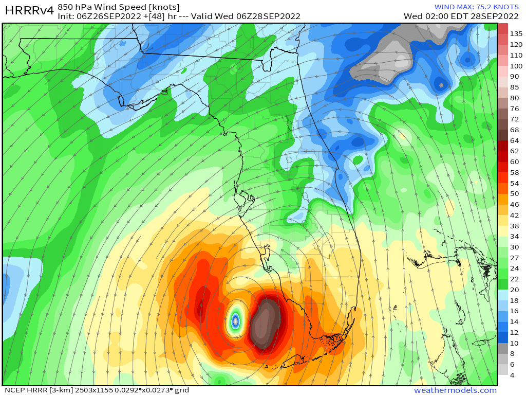
NDG wrote:kevin wrote:Fancy1001 wrote:Really bad HMON run.
Yep, high-end cat 4 right into Tampa...
https://i.imgur.com/wsNlTj4.png
HMON does pretty good on it forecast track, usually.
Short term yes. So this is a bit scary IMO.
1 likes
Once I see the REDS and GREENS Converge on a Base Velocity. ... I'm There!!
This is NOT an Official Forecast....Just my Opinion. For official information, please refer to the NHC and NWS products.
HIGHLIGHTS : '13 El Reno Tornado : 2013 Storm Chaser Tour, Joaquin; SC flood event, Matthew '16, Lowcountry Snow storm Jan '18
This is NOT an Official Forecast....Just my Opinion. For official information, please refer to the NHC and NWS products.
HIGHLIGHTS : '13 El Reno Tornado : 2013 Storm Chaser Tour, Joaquin; SC flood event, Matthew '16, Lowcountry Snow storm Jan '18
-
Category5Kaiju

- Category 5

- Posts: 4335
- Joined: Thu Dec 24, 2020 12:45 pm
- Location: Seattle and Phoenix
Re: ATL: IAN - Models
Kohlecane wrote:NDG wrote:
HMON does pretty good on it forecast track, usually.
Short term yes. So this is a bit scary IMO.
Yeah that run was basically a “what if Charley succeeded in its initial projected track.” The main difference is likely that Ian will likely be much larger than Charley, which would increase the scope of possible destruction.
1 likes
Unless explicitly stated, all info in my posts is based on my own opinions and observations. Tropical storms and hurricanes can be extremely dangerous. Refer to an accredited weather research agency or meteorologist if you need to make serious decisions regarding an approaching storm.

Re: ATL: IAN - Models
I know its the NAM, but the 06z takes a sharp right hook into Port Charlotte area.
2 likes


-
ColdMiser123

- Professional-Met

- Posts: 905
- Age: 29
- Joined: Mon Sep 26, 2016 3:26 pm
- Location: Northeast US
Re: ATL: IAN - Models
Euro will be a decent amount west of 0z, will spare Tampa the worst wind impacts this run.
2 likes
B.S., M.S., Meteorology & Atmospheric Science

Re: ATL: IAN - Models
I could be wrong, but I think the stronger it gets before the Cuba crossover, the greater the likelihood that it ends up West and not East
1 likes

-
Blown Away

- S2K Supporter

- Posts: 10253
- Joined: Wed May 26, 2004 6:17 am
Re: ATL: IAN - Models
Could it be, finally, the Euro is W of the GFS??? 
1 likes
Hurricane Eye Experience: David 79, Irene 99, Frances 04, Jeanne 04, Wilma 05… Hurricane Brush Experience: Andrew 92, Erin 95, Floyd 99, Matthew 16, Irma 17, Ian 22, Nicole 22…
-
drewschmaltz
- S2K Supporter
- Posts: 351
- Joined: Thu Aug 27, 2015 8:19 pm
Re: ATL: IAN - Models
We are still a long way out. Things will change. But as EURO and GFS come into close alignment, we can see those that said "the solutions will meet in the middle" are very much, so far, correct. The more northerly motion instead of the curve East around the ridge is what the GFS insisted. Interesting. But if course, we will see what actually happens. Being in Orlando I hate these forecasts. When we are less than 24 hours out, I'm guessing we still won't know if the eyewall is coming ashore.
2 likes
I HAVE ABSOLUTELY NO IDEA WHAT I'M TALKING ABOUT. PLEASE CONSULT SOMEONE WHO DOES. START WITH THE NHC. ALL POSTS ARE FOR ENTERTAINMENT PURPOSES ONLY.

-
toad strangler

- S2K Supporter
- Posts: 4546
- Joined: Sun Jul 28, 2013 3:09 pm
- Location: Earth
- Contact:
Re: ATL: IAN - Models
WOW that is a huge shift W by the Euro!
2 likes
My Weather Station
https://www.wunderground.com/dashboard/pws/KFLPORTS603
https://www.wunderground.com/dashboard/pws/KFLPORTS603

Re: ATL: IAN - Models
the 6z and 18z euro runs have been a bit wacky, let's see what the 0z looks like
2 likes
Just like Jon Snow..."I know nothing" except what I know, and most of what I know is gathered by the fine people of the NHC
-
Blown Away
- S2K Supporter
- Posts: 10253
- Joined: Wed May 26, 2004 6:17 am
Re: ATL: IAN - Models
The Euro is W of the GFS at @72 hours for the first time. I would think this gives a clearer picture for the NHC with the models and there bias and now we watch the GFS to see if it sees a deeper trough and continues it's E trend.
1 likes
Hurricane Eye Experience: David 79, Irene 99, Frances 04, Jeanne 04, Wilma 05… Hurricane Brush Experience: Andrew 92, Erin 95, Floyd 99, Matthew 16, Irma 17, Ian 22, Nicole 22…


-
chris_fit

- Category 5
- Posts: 3261
- Age: 43
- Joined: Wed Sep 10, 2003 11:58 pm
- Location: Tampa Bay Area, FL
Re: ATL: IAN - Models
Final Frame of 06Z run vs 96hrs @ 00Z Run
Was NOT expecting that, at all. What the caused this big shift?

Was NOT expecting that, at all. What the caused this big shift?
2 likes
Who is online
Users browsing this forum: No registered users and 22 guests