ATL: IAN - Post-Tropical - Discussion
Moderator: S2k Moderators
-
InfernoFlameCat

- Category 5

- Posts: 2127
- Age: 22
- Joined: Mon Dec 14, 2020 10:52 am
- Location: Buford, GA
Re: ATL: IAN - Hurricane - Discussion
EWRC is taking place. Large outer eyewall has fully formed and the inner eyewall is becoming ill defined.
3 likes
I am by no means a professional. DO NOT look at my forecasts for official information or make decisions based on what I post.
Goal: to become a registered expert over tropical and subtropical cyclones.
Goal: to become a registered expert over tropical and subtropical cyclones.
-
Iceresistance

- Category 5
- Posts: 9564
- Age: 22
- Joined: Sat Oct 10, 2020 9:45 am
- Location: Tecumseh, OK/Norman, OK
Re: ATL: IAN - Hurricane - Discussion
OuterBanker wrote:OMG Weathnerds is overloaded
Yeah, it's been happening with me for the past couple of hours.
1 likes
Bill 2015 & Beta 2020
Winter 2020-2021
All observations are in Tecumseh, OK unless otherwise noted.
Winter posts are focused mainly for Oklahoma & Texas.
Take any of my forecasts with a grain of salt, refer to the NWS, SPC, and NHC for official information
Never say Never with weather! Because ANYTHING is possible!
Winter 2020-2021
All observations are in Tecumseh, OK unless otherwise noted.
Winter posts are focused mainly for Oklahoma & Texas.
Take any of my forecasts with a grain of salt, refer to the NWS, SPC, and NHC for official information
Never say Never with weather! Because ANYTHING is possible!
-
jlauderdal
- S2K Supporter

- Posts: 7240
- Joined: Wed May 19, 2004 5:46 am
- Location: NE Fort Lauderdale
- Contact:
Re: RE: Re: ATL: IAN - Hurricane - Discussion
They follow tvcn very closely, its their bible for a good reason.Blown Away wrote:jlauderdal wrote:The southerly track is going to be really favorable compared to tampa and north.CrazyC83 wrote:I'd conservatively go 110 kt with a 948 mb pressure for the advisory. It's possible it has strengthened more but we won't know until Recon gets back into the core this evening.
Does NHC just follow TVCN or do they show if they anticipate more E movement??
1 likes

Re: RE: Re: ATL: IAN - Hurricane - Discussion
jlauderdal wrote:Wow, thought disney might try for friday especially with all the kids off school.CronkPSU wrote:Publix, Universal and Disney closing tonight thru Friday, don't get more real than that here in Central Florida
sorry i guess that was not what i meant...they are all planning on opening on Friday...
1 likes
Just like Jon Snow..."I know nothing" except what I know, and most of what I know is gathered by the fine people of the NHC
-
cheezyWXguy

- Category 5
- Posts: 6280
- Joined: Mon Feb 13, 2006 12:29 am
- Location: Dallas, TX
Re: ATL: IAN - Hurricane - Discussion
Outer eyewall is nearly fully formed on radar, but it’s over 60 miles wide. Gonna be a while before it becomes dominant, and how long it takes will depend on how fast it contracts. Those newer deep bursts look to be in that outer eyewall, so they may help it contract a bit faster
5 likes
-
zeehag
- Tropical Storm

- Posts: 181
- Age: 77
- Joined: Sun Jul 17, 2011 9:49 pm
- Location: mazatlan,sinaloa, mexico, fixing patricia's mess.
- Contact:
Re: ATL: IAN - Hurricane - Discussion
mcheer23 wrote:MetsIslesNoles wrote:CronkPSU wrote:Publix, Universal and Disney closing tonight thru Friday, don't get more real than that here in Central Florida
But is Waffle House still open?
Nope
O M G that is serious..
7 likes
-
Wakeknight
- Tropical Low

- Posts: 26
- Joined: Fri Sep 02, 2016 7:37 am
- Location: Nokomis, FL

Re: ATL: IAN - Hurricane - Discussion
1 likes
Just like Jon Snow..."I know nothing" except what I know, and most of what I know is gathered by the fine people of the NHC

Re: ATL: IAN - Hurricane - Discussion
The cirrus outflow from the tower is covering the eye making it look ragged
3 likes

Re: ATL: IAN - Hurricane - Discussion
Just thinking back a couple of days ago people were saying that this was going to be another Ivan in that the track kept moving west but this looks like it may end up close to another Charley, making landfall further south, another MH which Tampa Bay misses a direct hit.
6 likes
-
cheezyWXguy
- Category 5
- Posts: 6280
- Joined: Mon Feb 13, 2006 12:29 am
- Location: Dallas, TX

Re: ATL: IAN - Hurricane - Discussion
Mesoscale Discussion 1835
NWS Storm Prediction Center Norman OK
0327 PM CDT Tue Sep 27 2022
https://www.spc.noaa.gov/products/md/md1835.html
Areas affected...Southern FL and the FL Keys
Concerning...Severe potential...Watch needed soon
Valid 272027Z - 272100Z
Probability of Watch Issuance...95 percent
SUMMARY...A new Tornado Watch will be issued for South FL and the FL
Keys by 21Z.
DISCUSSION...The supercell tornado risk will continue across
southern FL and the Keys on the northeastern side of Hurricane Ian,
and gradually spread northward through this afternoon into the
overnight hours. Therefore, a new Tornado Watch will be issued by
21Z.
1 likes
Re: ATL: IAN - Hurricane - Discussion
Disagree, it points more towards Ft Myers if not Port Charlotte, not Naples.
4 likes

Re: ATL: IAN - Hurricane - Discussion
From 5PM Forecast Discussion
The pressure on the last Air Force Hurricane Hunter aircraft fix
fell to about 952 mb, indicating that Ian is restrengthening
over the southeastern Gulf of Mexico. The eye of Ian remains
well-defined on visible imagery, although radar data from Key West
suggest that an eyewall replacement could be in the initial stages.
The initial wind speed is set to 105 kt, matching a blend of
earlier SFMR and flight-level wind data. The plane data also
showed that the area of hurricane-force winds is growing on the
east side of the cyclone.
5 likes

Re: ATL: IAN - Hurricane - Discussion
I’m surprised they stuck with the 2pm intensity for the 5pm advisory. Even with the EWRC, Ian has likely deepened another few mbar since recon left.
3 likes
Irene '11 Sandy '12 Hermine '16 5/15/2018 Derecho Fay '20 Isaias '20 Elsa '21 Henri '21 Ida '21
I am only a meteorology enthusiast who knows a decent amount about tropical cyclones. Look to the professional mets, the NHC, or your local weather office for the best information.
I am only a meteorology enthusiast who knows a decent amount about tropical cyclones. Look to the professional mets, the NHC, or your local weather office for the best information.


Re: ATL: IAN - Hurricane - Discussion
zeehag wrote:mcheer23 wrote:MetsIslesNoles wrote:
But is Waffle House still open?
Nope
O M G that is serious..
We have one right by my house, I'm keeping an eye on it.
For those on here that don't know about the Waffle House Index, it's a real measurement by FEMA unofficially.
https://en.wikipedia.org/wiki/Waffle_House_Index
https://www.usatoday.com/story/news/nation-now/2017/09/07/how-fema-uses-waffle-houses-disasters/641145001/
8 likes
-
Iceresistance
- Category 5
- Posts: 9564
- Age: 22
- Joined: Sat Oct 10, 2020 9:45 am
- Location: Tecumseh, OK/Norman, OK
Re: ATL: IAN - Hurricane - Discussion
Incoming! 
NOAA3 Mission #25 into IAN
Type: Unknown | Status: In Progress
Type: Unknown | Status: In Progress
2 likes
Bill 2015 & Beta 2020
Winter 2020-2021
All observations are in Tecumseh, OK unless otherwise noted.
Winter posts are focused mainly for Oklahoma & Texas.
Take any of my forecasts with a grain of salt, refer to the NWS, SPC, and NHC for official information
Never say Never with weather! Because ANYTHING is possible!
Winter 2020-2021
All observations are in Tecumseh, OK unless otherwise noted.
Winter posts are focused mainly for Oklahoma & Texas.
Take any of my forecasts with a grain of salt, refer to the NWS, SPC, and NHC for official information
Never say Never with weather! Because ANYTHING is possible!
Re: ATL: IAN - Hurricane - Discussion
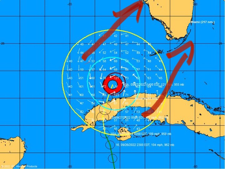
What are those arrows pointing too? That isnt the forecast track
3 likes
-
Hypercane_Kyle

- Category 5
- Posts: 3465
- Joined: Sat Mar 07, 2015 7:58 pm
- Location: Cape Canaveral, FL
Re: ATL: IAN - Hurricane - Discussion
aspen wrote:I’m surprised they stuck with the 2pm intensity for the 5pm advisory. Even with the EWRC, Ian has likely deepened another few mbar since recon left.
There's another recon not far away, no point in upping the intensity if we'll know for soon shortly.
2 likes
My posts are my own personal opinion, defer to the National Hurricane Center (NHC) and other NOAA products for decision making during hurricane season.
Who is online
Users browsing this forum: No registered users and 16 guests