
ATL: IAN - Post-Tropical - Discussion
Moderator: S2k Moderators
-
weeniepatrol

- Category 5

- Posts: 1339
- Joined: Sat Aug 22, 2020 5:30 pm
- Location: WA State

Re: ATL: IAN - Hurricane - Discussion
Any chance the ERC prevents further intensification?
1 likes
The above post is not official and should not be used as such. It is the opinion of the poster and may or may not be backed by sound meteorological data. It is not endorsed by any professional institution or storm2k.org. For official information, please refer to the NHC and NWS products.
-
CrazyC83
- Professional-Met

- Posts: 34311
- Joined: Tue Mar 07, 2006 11:57 pm
- Location: Deep South, for the first time!
Re: ATL: IAN - Hurricane - Discussion
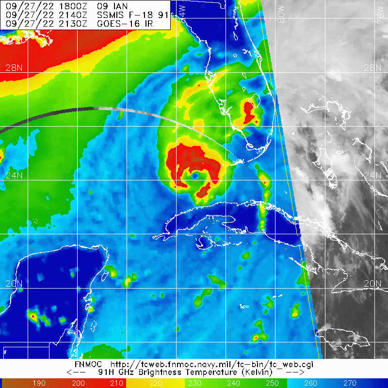
It seems that dry air is more of an issue looking at that dropsonde, but it is not preventing deepening. I'd think it would be explosively deepening if not for the dry air entrainment, and that is just holding it somewhat in check.
8 likes
-
Iceresistance

- Category 5
- Posts: 9564
- Age: 22
- Joined: Sat Oct 10, 2020 9:45 am
- Location: Tecumseh, OK/Norman, OK
Re: ATL: IAN - Hurricane - Discussion
Noticed that the Outer Southern Eyewall is stronger than the Southern Inner Eyewall in the FL Winds.
2 likes
Bill 2015 & Beta 2020
Winter 2020-2021
All observations are in Tecumseh, OK unless otherwise noted.
Winter posts are focused mainly for Oklahoma & Texas.
Take any of my forecasts with a grain of salt, refer to the NWS, SPC, and NHC for official information
Never say Never with weather! Because ANYTHING is possible!
Winter 2020-2021
All observations are in Tecumseh, OK unless otherwise noted.
Winter posts are focused mainly for Oklahoma & Texas.
Take any of my forecasts with a grain of salt, refer to the NWS, SPC, and NHC for official information
Never say Never with weather! Because ANYTHING is possible!


Re: ATL: IAN - Hurricane - Discussion
OuterBanker wrote:OMG Weathnerds is overloaded
And that is why I love this place.
4 likes
-
SconnieCane
- Category 5
- Posts: 1013
- Joined: Thu Aug 02, 2018 5:29 pm
- Location: Madison, WI
Re: ATL: IAN - Hurricane - Discussion
Actually not bad tornado chase territory there, pretty flat with good visibility/some but not too many trees. Gotta watch out for gators, though!
4 likes

Re: ATL: IAN - Hurricane - Discussion
Owasso wrote:https://i.postimg.cc/gkyBbnj4/A3-B551-F1-0033-4-ACA-8-BEC-E44-CE60-E6441.jpg
Looks like the ERC (if there was one) has gone seamlessly.
Still plenty of debris from the inner eyewall, and that gap in the southern eyewall could be enough for dry air to get in and cripple Ian. The longer this takes to recover, the greater chance shear can knock this down a few pegs before landfall.
1 likes
Irene '11 Sandy '12 Hermine '16 5/15/2018 Derecho Fay '20 Isaias '20 Elsa '21 Henri '21 Ida '21
I am only a meteorology enthusiast who knows a decent amount about tropical cyclones. Look to the professional mets, the NHC, or your local weather office for the best information.
I am only a meteorology enthusiast who knows a decent amount about tropical cyclones. Look to the professional mets, the NHC, or your local weather office for the best information.
-
InfernoFlameCat

- Category 5
- Posts: 2127
- Age: 22
- Joined: Mon Dec 14, 2020 10:52 am
- Location: Buford, GA
Re: ATL: IAN - Hurricane - Discussion
Inner eyewall appears to have caught on to outer eyeball's shenanigans. It now has latched on to the outer eyewall and is restrengthening.
3 likes
I am by no means a professional. DO NOT look at my forecasts for official information or make decisions based on what I post.
Goal: to become a registered expert over tropical and subtropical cyclones.
Goal: to become a registered expert over tropical and subtropical cyclones.
-
tolakram
- Admin

- Posts: 20172
- Age: 62
- Joined: Sun Aug 27, 2006 8:23 pm
- Location: Florence, KY (name is Mark)
Re: ATL: IAN - Hurricane - Discussion
6 likes
M a r k
- - - - -
Join us in chat: Storm2K Chatroom Invite. Android and IOS apps also available.
The posts in this forum are NOT official forecasts and should not be used as such. Posts are NOT endorsed by any professional institution or STORM2K.org. For official information and forecasts, please refer to NHC and NWS products.
-
Iceresistance
- Category 5
- Posts: 9564
- Age: 22
- Joined: Sat Oct 10, 2020 9:45 am
- Location: Tecumseh, OK/Norman, OK
Re: ATL: IAN - Hurricane - Discussion

1 likes
Bill 2015 & Beta 2020
Winter 2020-2021
All observations are in Tecumseh, OK unless otherwise noted.
Winter posts are focused mainly for Oklahoma & Texas.
Take any of my forecasts with a grain of salt, refer to the NWS, SPC, and NHC for official information
Never say Never with weather! Because ANYTHING is possible!
Winter 2020-2021
All observations are in Tecumseh, OK unless otherwise noted.
Winter posts are focused mainly for Oklahoma & Texas.
Take any of my forecasts with a grain of salt, refer to the NWS, SPC, and NHC for official information
Never say Never with weather! Because ANYTHING is possible!

Re: ATL: IAN - Hurricane - Discussion
NWS Alert> Potential Tornado 8 Miles S of Hendry Correctional or 15 Miles SE of Ave Maria Moving NW At 30 MPH. Locations Impacted Include Ave Maria, Hendry Correctional & Sunniland.
1 likes
-
TheHurricaneGod
- Tropical Storm

- Posts: 165
- Age: 23
- Joined: Thu Apr 16, 2020 6:19 pm
- Location: Fort Lauderdale
Re: ATL: IAN - Hurricane - Discussion
Looks like the movement has become more north instead of NE. Not sure if still east of the forecast track.
2 likes

Re: ATL: IAN - Hurricane - Discussion
SconnieCane wrote:
Actually not bad tornado chase territory there, pretty flat with good visibility/some but not too many trees. Gotta watch out for gators, though!
Only downside is that it's only got two directions, not a lot of cross streets or highways. Good in a situation like today where tornados were moving S to NW, but would be really risky if they were moving parallel to the highway.
2 likes
Andrew (1992), Irene (1999), Frances (2004), Katrina (2005), Wilma (2005), Fay (2008), Irma (2017), Eta (2020), Ian (2022)
Re: ATL: IAN - Hurricane - Discussion
I think the AF plane took off and immediately returned to base.
1 likes
Re: ATL: IAN - Hurricane - Discussion
The EWRC seems to be still underway indicated by the 84% RH on latest drop.
Infeed is being pinched off by the outer eyewall
Infeed is being pinched off by the outer eyewall
4 likes
-
cheezyWXguy

- Category 5
- Posts: 6280
- Joined: Mon Feb 13, 2006 12:29 am
- Location: Dallas, TX
Re: ATL: IAN - Hurricane - Discussion
Impressive that the outer eyewall is already stronger in the se quad and about the same in the nw. Looks on radar like the outer eye is only about 40 miles wide now too
1 likes
-
ScottNAtlanta

- Category 5
- Posts: 2535
- Joined: Sat May 25, 2013 3:11 pm
- Location: Atlanta, GA
Re: ATL: IAN - Hurricane - Discussion
FYI...the last two "I" storms on this list Ivan and Igor were both retired...I'd say we now have a third.
5 likes
The posts in this forum are NOT official forecast and should not be used as such. They are just the opinion of the poster and may or may not be backed by sound meteorological data. They are NOT endorsed by any professional institution or storm2k.org. For official information, please refer to the NHC and NWS products.
-
KirbyDude25

- Tropical Storm
- Posts: 161
- Age: 20
- Joined: Mon Sep 20, 2021 8:03 am
- Location: Westfield, New Jersey
Re: ATL: IAN - Hurricane - Discussion
cheezyWXguy wrote:
Impressive that the outer eyewall is already stronger in the se quad and about the same in the nw. Looks on radar like the outer eye is only about 40 miles wide now too
Considering a few hours ago we were doubting if this even was an ERC, it looks to be doing it pretty quickly. I wouldn't be surprised if it was done by midnight
3 likes
New Jersey, Rutgers '27
Irene 2011 | Sandy 2012 | Fay 2020 | Isaias 2020 | Ida 2021
Irene 2011 | Sandy 2012 | Fay 2020 | Isaias 2020 | Ida 2021
-
floridasun
- Tropical Storm
- Posts: 245
- Joined: Tue Sep 14, 2021 3:59 pm
Re: ATL: IAN - Hurricane - Discussion
do think ts warring may be upgaade to hurrrwarring in se fl? look like strong band will get closer to dade and se coast?????
0 likes

Re: ATL: IAN - Hurricane - Discussion
KirbyDude25 wrote:cheezyWXguy wrote:
Impressive that the outer eyewall is already stronger in the se quad and about the same in the nw. Looks on radar like the outer eye is only about 40 miles wide now too
Considering a few hours ago we were doubting if this even was an ERC, it looks to be doing it pretty quickly. I wouldn't be surprised if it was done by midnight
that would give it waaaaayyyy too much time under hot water and low shear to get bigger and maybe even stronger before landfall
5 likes
Just like Jon Snow..."I know nothing" except what I know, and most of what I know is gathered by the fine people of the NHC
Who is online
Users browsing this forum: No registered users and 22 guests