ATL: IAN - Post-Tropical - Discussion
Moderator: S2k Moderators

Re: ATL: IAN - Hurricane - Discussion
re: the surge issue. I dont see why the surge prediction would have varied that much from a high end cat 3 to a cat 4/5. I am never one to dunk on NHC, they do they best they can and they gave the best information they could...but There will no doubt be stories or folks in cape coral and fort meyers who stayed and needed to go into attics. My friend that survived katrina surge only got out because they had a ladder handy. Her husband had to carry granny (who used a walker) up the ladder and plunk her through the ceiling hole. Hopefully people knew the risks and got out...sounds like most did.
10 likes
-
tolakram
- Admin

- Posts: 20168
- Age: 62
- Joined: Sun Aug 27, 2006 8:23 pm
- Location: Florence, KY (name is Mark)
Re: ATL: IAN - Hurricane - Discussion
Saved loop (Sanibel Island Webcams)
Putting webcam links in this thread: https://www.storm2k.org/phpbb2/viewtopic.php?f=59&t=123066
Putting webcam links in this thread: https://www.storm2k.org/phpbb2/viewtopic.php?f=59&t=123066
13 likes
M a r k
- - - - -
Join us in chat: Storm2K Chatroom Invite. Android and IOS apps also available.
The posts in this forum are NOT official forecasts and should not be used as such. Posts are NOT endorsed by any professional institution or STORM2K.org. For official information and forecasts, please refer to NHC and NWS products.
-
cheezyWXguy

- Category 5

- Posts: 6242
- Joined: Mon Feb 13, 2006 12:29 am
- Location: Dallas, TX

-
Blown Away

- S2K Supporter

- Posts: 10253
- Joined: Wed May 26, 2004 6:17 am
Re: ATL: IAN - Hurricane - Discussion
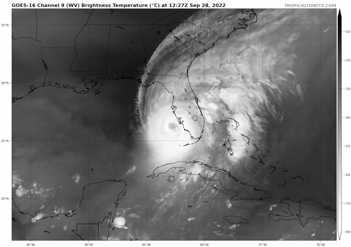
From satellite looks like very slow ENE drift just offshore.
5 likes
Hurricane Eye Experience: David 79, Irene 99, Frances 04, Jeanne 04, Wilma 05… Hurricane Brush Experience: Andrew 92, Erin 95, Floyd 99, Matthew 16, Irma 17, Ian 22, Nicole 22…
-
Tireman4

- S2K Supporter
- Posts: 5867
- Age: 60
- Joined: Fri Jun 30, 2006 1:08 pm
- Location: Humble, Texas
- Contact:
Re: ATL: IAN - Hurricane - Discussion
wxman57 wrote:Note that the NHC's 12-16 ft surge into Port Charlotte/Ft. Myers is for the BEACH. Surge up the Caloosahatchee river into Ft. Myers could be 20-24 ft. Similar for Port Charlotte and Punta Gorda. See the NHC's inundation graphic for the region. MANY areas under 9+ ft of water this afternoon. Far as I can tell, this will be the worst hurricane ever to strike the area. Charley in 2004 was strong, but tiny compared to Ian. Ian will be retired.
Josh Morgerman should get rare video of a daytime landfall. Any link to him or Mark Sudduth coverage?
I think both are in the Ian: Local Reports and Webcam thread. I know Mark's is
3 likes
-
Rail Dawg
- S2K Supporter
- Posts: 326
- Joined: Mon Aug 27, 2012 5:02 pm
- Location: Where the eye makes landfall.
Re: ATL: IAN - Hurricane - Discussion
Fists of God:
When in the inner eyewall of a 140mph+ hurricane I have twice discovered a phenomenon I have named the Fists of God.
The wind will be pushing say 150mph steady. You hear what sounds like an F-18 flying right over your head maybe 1000 feet above you.
Count to ten and a massive fist of water and wind maybe 200 feet wide comes out of the sky punching down at an angle to the ground. These are the real gusts of the hurricane. Whatever this Fist hits unless reinforced almost appears to explode during its destruction.
The most powerful Fists of God in the very inner eyewall are incredibly destructive. You will watch a 300-year-old oak tree uprooted like a matchstick. But the huge oak right next to it is unscathed because the Fist was so concentrated.
I don’t want to bore folks with repeating some things but some things need to be repeated.
Observing the Fists of God from a concrete-reinforced parking structure is far different than observing them from a wood house with no protection. It is unbelievable to me that once again people are going to “ride this out”. The inner eyewall of Ian is going to be incredibly loud and destructive. The Fists of God will be raining down.
Chuck
18 likes
Although I have been a hurricane forecaster since 1980 that only means I've been wrong lots of times.

Re: ATL: IAN - Hurricane - Discussion
TallyTracker wrote:SohCahToa wrote:wx98 wrote:You can easily infer that the storm has continued strengthening over the last three hours and has likely crossed the threshold.
I’m no scientist, forecaster, or have any education on the weather outside of where my hurricane enthusiasm has led online and on these boards. It seems to me that we see A LOT of estimations made by the NHC in all kinds of situations, so it seems crazy to me that with some of the recon data we had a few hours ago they wouldn’t upgrade based on estimations. I understand wanting things to be confirmed, but it just seems like they are the most strict on that when determining whether to upgrade to Cat 5 only.
The NHC doesn’t operationally upgrade to Cat 5 often in these situations likely to avoid further panic. As soon as it’s an official Cat 5, the media will go bonkers more than before and people may try to panic leave at a time when it’s not safe to do so. The record can be updated later but the NHC is more in the business of saving lives rather than making sure the record is straight operationally. 155 mph is just as bad as 160 anyway so no need to upgrade unless absolutely necessary and undisputed.
Appreciate the reply. That actually makes a lot of sense.
5 likes
-
hurricaneCW
- Category 5
- Posts: 1799
- Joined: Wed Mar 03, 2010 6:20 am
- Location: Toms River, NJ
Re: ATL: IAN - Hurricane - Discussion
Teban54 wrote:FLpanhandle91 wrote:Eye continues to warm.
If there's a silver lining, the CDO also warmed somewhat in recent frames.
Probably not any indication of weakening though, and even if it is, way too late at this point.
Clouds warm during the day and as we approach Dmin. I don't see much weakening prior to landfall unfortunately
6 likes
-
FLpanhandle91

- Category 5
- Posts: 1039
- Age: 34
- Joined: Mon Sep 13, 2010 3:50 pm
- Location: Fort Walton Beach, FL
Re: ATL: IAN - Hurricane - Discussion
Teban54 wrote:FLpanhandle91 wrote:Eye continues to warm.
If there's a silver lining, the CDO also warmed somewhat in recent frames.
Probably not any indication of weakening though, and even if it is, way too late at this point.
That is the sun warming the top of the cloud tops.
11 likes
-
AmandaInDestin
- Tropical Wave

- Posts: 9
- Joined: Fri Sep 23, 2022 8:56 pm
Re: ATL: IAN - Hurricane - Discussion
PTPatrick wrote:re: the surge issue. I dont see why the surge prediction would have varied that much from a high end cat 3 to a cat 4/5. I am never one to dunk on NHC, they do they best they can and they gave the best information they could...but There will no doubt be stories or folks in cape coral and fort meyers who stayed and needed to go into attics. My friend that survived katrina surge only got out because they had a ladder handy. Her husband had to carry granny (who used a walker) up the ladder and plunk her through the ceiling hole. Hopefully people knew the risks and got out...sounds like most did.
God… I hope they got out. Why would anyone stay for such a thing? I can’t stomach the thought of it. Just watching videos of the destruction from the outer bands from last night are bad. I can’t imagine what is to come.
4 likes
-
Coolcruiseman
- Tropical Depression

- Posts: 97
- Age: 51
- Joined: Wed Sep 21, 2022 8:10 pm
- Location: Melbourne, FL
Re: ATL: IAN - Hurricane - Discussion
Currently sustained NNE winds of 26 mph with rain bands right off shore here in the Melbourne area.
4 likes

Re: ATL: IAN - Hurricane - Discussion
Perhaps the best Ian has looked on visible so far this morning:

11 likes
Re: ATL: IAN - Hurricane - Discussion
Watching progression from our “safe place” with no access to a live cast. Does somebody have a link to a good live radar (not delayed too long)?
Also, what is forward speed and direction now? TIA.
Also, what is forward speed and direction now? TIA.
2 likes
Cleo - 1964, Betsy - 1965, David - 1979, Andrew - 1992, Charlie (Francis, Ivan, Jeanne) - 2004, Irma - 2017, Ian - 2022, Milton - 2024

Re: ATL: IAN - Hurricane - Discussion
cheezyWXguy wrote:[url]https://i.ibb.co/kJ07yKH/FFD29-A2-D-AD65-461-A-8075-130-E92-B9-D6-D6.png [/url]
How do you access the wind speed radar?
0 likes
-
TallyTracker
- Category 2

- Posts: 783
- Joined: Thu Oct 11, 2018 2:46 pm
Re: ATL: IAN - Hurricane - Discussion
I see why the ADT numbers are dropping. The overall thickness of the CDO is shrinking. May be the beginning of more shear and dry air having an impact. Don’t expect significant weakening though.
4 likes
Fran '96, Georges '98, Gordon '00, Gabrielle '01, Charley '04, Frances '04, Jeanne '04, Barry '07, Fay '08, Debby '12, Matthew '16, Emily '17, Irma '17, Michael ‘18, Elsa ‘21, Fred ‘21, Mindy ‘21, Nicole ‘22, Idalia ‘23, Debby ‘24, Helene ‘24
-
Iceresistance

- Category 5
- Posts: 9441
- Age: 22
- Joined: Sat Oct 10, 2020 9:45 am
- Location: Tecumseh, OK/Norman, OK
Re: ATL: IAN - Hurricane - Discussion
Abdullah wrote:cheezyWXguy wrote:[url]https://i.ibb.co/kJ07yKH/FFD29-A2-D-AD65-461-A-8075-130-E92-B9-D6-D6.png [/url]
How do you access the wind speed radar?
Velocity in Radarscope
4 likes
Bill 2015 & Beta 2020
Winter 2020-2021
All observations are in Tecumseh, OK unless otherwise noted.
Winter posts are focused mainly for Oklahoma & Texas.
Take any of my forecasts with a grain of salt, refer to the NWS, SPC, and NHC for official information
Never say Never with weather! Because ANYTHING is possible!
Winter 2020-2021
All observations are in Tecumseh, OK unless otherwise noted.
Winter posts are focused mainly for Oklahoma & Texas.
Take any of my forecasts with a grain of salt, refer to the NWS, SPC, and NHC for official information
Never say Never with weather! Because ANYTHING is possible!
-
ElectricStorm

- Category 5
- Posts: 5122
- Age: 24
- Joined: Tue Aug 13, 2019 11:23 pm
- Location: Skiatook, OK / Norman, OK
Re: ATL: IAN - Hurricane - Discussion
Michele B wrote:Watching progression from our “safe place” with no access to a live cast. Does somebody have a link to a good live radar (not delayed too long)?
Also, what is forward speed and direction now? TIA.
As of the most recent update, NHC has it at NNE at 10mph
10:00 AM EDT Wed Sep 28
Location: 26.2°N 82.7°W
Moving: NNE at 10 mph
Min pressure: 937 mb
Max sustained: 155 mph
Location: 26.2°N 82.7°W
Moving: NNE at 10 mph
Min pressure: 937 mb
Max sustained: 155 mph
They're updating it every hour
2 likes
B.S Meteorology, University of Oklahoma '25
Please refer to the NHC, NWS, or SPC for official information.
Please refer to the NHC, NWS, or SPC for official information.
-
ThunderForce

- Tropical Storm

- Posts: 208
- Age: 26
- Joined: Tue Sep 27, 2022 6:20 pm
- Location: Calhoun County, Florida
Re: ATL: IAN - Hurricane - Discussion
On radar it looks more like Ian is moving east of due north than NNE to me. Eastern movement seems to be a bit slower than the northward movement.
2 likes
Please refer to the NWS, NHC, SPC or a professional meteorologist for information and decision making during storms.
Re: ATL: IAN - Hurricane - Discussion
ElectricStorm wrote:Michele B wrote:Watching progression from our “safe place” with no access to a live cast. Does somebody have a link to a good live radar (not delayed too long)?
Also, what is forward speed and direction now? TIA.
As of the most recent update, NHC has it at NNE at 10mph10:00 AM EDT Wed Sep 28
Location: 26.2°N 82.7°W
Moving: NNE at 10 mph
Min pressure: 937 mb
Max sustained: 155 mph
They're updating it every hour
Thank you.
1 likes
Cleo - 1964, Betsy - 1965, David - 1979, Andrew - 1992, Charlie (Francis, Ivan, Jeanne) - 2004, Irma - 2017, Ian - 2022, Milton - 2024
Re: ATL: IAN - Hurricane - Discussion
kevin wrote:Perhaps the best Ian has looked on visible so far this morning:
https://i.imgur.com/Nis4fBs.jpg
is that a pinhole eye?
2 likes
Who is online
Users browsing this forum: No registered users and 17 guests